

Research progress on the in-situ monitoring technologies of marine geohazards
-
摘要: 海洋地质灾害对沿海城市人口和海洋经济发展构成重大威胁。海岸港口航道、海底管线光缆、海洋平台基础等工程建设规模的扩大,意味着海洋地质灾害风险进一步提高。海底火山爆发、海啸等大规模但不常见的灾害事件吸引了大多数公众关注和媒体报道,并促使政策调整以防范化解灾害风险。然而,海底气体喷溢、海底滑坡等小规模但更频繁的原生灾害事件,会产生严重的局部影响,并且极易转变为灾害链导致灾害事件恶化,但社会公众在很大程度上没有足够重视此类灾害风险。迄今为止,大多数海洋地质灾害的特征都可以被探测识别,但依靠现有的技术却很难有效监测。海洋地质灾害的原位监测需要更加严苛的技术能力,特别是突发性海洋地质灾害的原位监测难度较大。综述首先介绍了海洋地质灾害原位监测的意义以及技术发展的挑战,然后对海洋地质灾害的监测要素进行总结探讨,重点阐述海洋地质灾害监测技术装备的应用情况,并对海洋地质灾害的风险评估和灾害预警进行分析探讨,最后对海洋地质灾害原位监测技术及其应用作了总结和展望。综述旨在分析总结海洋地质灾害类型的监测技术装备及其应用中涉及的一些核心技术和急需解决的关键问题,以期为该项技术发展和应用提供借鉴。Abstract: Marine geohazards pose a major threat to the population and marine economic development of coastal cities. The expansion of construction of coastal port channels, submarine pipelines, optical cables, and marine platform foundations means that the risk of marine geohazards has further increased. Large-scale but uncommon disaster events such as submarine volcanic eruptions and tsunamis have attracted most of the public attention and media coverage and prompted policy adjustments to prevent and resolve disaster risks. However, small-scale but more frequent primary hazard events such as submarine gas leakages and submarine landslides, which can have severe localized impacts and are highly susceptible to transformation into hazard chains leading to worsening hazard events, are largely underappreciated by the public. To date, most features of marine geohazards can be detected and identified, but it is difficult to monitor effectively with existing technologies. In-situ monitoring of marine geohazards requires more demanding technical capabilities, especially in-situ monitoring of sudden-onset marine geohazards. The review first introduces the significance of in-situ monitoring of marine geohazards and the challenges of technology development, then summarizes and discusses the monitoring elements of marine geohazards, focuses on the application of marine geohazards monitoring technology and equipment, and analyzes and discusses the risk assessment and early warning of marine geohazards. Finally, summarizes outlooks on the marine geohazards in-situ monitoring technology and its application. The review aims to analyze and summarize some core technologies and key issues that need to be solved urgently in the monitoring technology and equipment of marine geohazards and their applications, in order to provide reference for the development and application of this technology.
-
0. 引言
近年来,我国地质灾害防治工作由隐患管理逐步向风险管理转变,作为地质灾害风险管理的支撑和依据,地质灾害风险评价越来越受重视[1]。
早在20世纪60年代,国外已开始研究地质灾害风险性相关内容[2]。联合国于1991年将地质灾害风险性正式定义为在一定时间与特定区域内,地质灾害发生时,对人类社会造成损失的期望值[3]。Remondo等[4]于2005年提出了新的基于统计学原理的地质灾害风险性评价方法。国内研究起步稍晚,吴树仁等[5]逐步把国外的风险管理理论引入国内。国土资源经济研究院主要致力于地质灾害易损性、风险评价、经济评价等方面的研究[6]。王佳佳等[7]以三峡库区万州区为例开展滑坡灾害易发性评价,为该区域滑坡灾害防治规划与预测预报提供技术支持。施成艳等[8]在对区域1∶5万地质灾害详细调查的基础上,利用综合指数法对地质灾害进行了易发区划分。李春燕等[9]采用地质灾害危险性与承灾体易损性分项测算,以定性综合评估的方式实现我国县域单元地质灾害风险评估。在国内外研究成果的支撑下,国务院于2020年部署了第一次全国自然灾害综合风险普查。作为六大灾种之一,地质灾害风险普查工作取得了阶段性进展,110个试点县已顺利完成,其中江苏省完成了徐州市铜山区和常州市金坛区两个县级试点。
从国内研究成果及相关工作部署来看,目前对于地质灾害易发性研究较多,且尺度一般以县级、城镇为主,缺乏系统的市级地质灾害风险性研究。本文以南京市为研究区,系统开展了易发性、危险性、易损性评价,并通过矩阵分析开展市级风险评价。相关成果为南京市地质灾害防灾减灾以及国土空间规划提供有效支撑,也为类似工作提供经验借鉴。
1. 研究区概况
研究区位于江苏省西南部,呈近南北走向“带状”,总面积6587 km2。
区域地处低山丘陵与平原过渡地带,境内有东西向的老山山脉、宁镇山脉横于长江两侧。构造上处于扬子板块上一个以震旦系为变质基底的长期凹陷带内,断裂根据走向大体可分为北北东向压扭性断裂、北西向张性断裂以及近东西向断裂。地层属华南地层大区下扬子分区,对地质灾害影响较大的地层岩性主要为震旦系至奥陶系以及中石炭统至下二叠统的碳酸盐岩、上侏罗统至白垩系的碎屑岩、第四系的黏土、粉质黏土。研究区属于北亚热带季风气候,多年平均降水量为1083.2 mm,其中6—9月为降雨集中期,多年平均降水量600.1 mm,约占全年降水量的53%。此外,作为长三角特大城市之一,工程建设密集繁多,不可避免的削坡、开挖坡脚等对边坡稳定性造成一定程度的破坏,区内每年排查新增的崩塌、滑坡地质灾害大多为因人类工程活动而导致的边坡失稳。
2. 地质灾害类型及时空分布特征
2.1 地质灾害类型特征
根据地质灾害历史数据统计显示,滑坡是区内数目最多、危害最大的地质灾害类型,其次为崩塌。截至2022年4月,研究区地质灾害隐患点共计202处,其中滑坡130处,占比64.36%;崩塌72处,占比35.64%。威胁人数约1196人,潜在经济损失约17758万元[10]。
研究区滑坡隐患点规模多为小型,长度基本小于100 m,宽度小于200 m,厚度一般为1 m左右,中型规模滑坡可达15 m,多呈复合式滑动。平面形态以半圆形为主,剖面形态以直线形和凹形为主。滑体性质主要为土质,研究区广泛分布的下蜀土具有吸水饱和后强度迅速降低的力学性质,易导致滑坡产生[11-14]。崩塌隐患点规模亦多为小型,呈拉裂式,主要发生于70°~90°的陡崖地段,以顺向坡为主,多在碳酸盐岩及砂岩等碎屑岩地层发育。
2.2 地质灾害时空分布特征
地质灾害在空间上的展布具有明显的不均匀性和区域集中性。主要在中部的沿江低山—丘陵区分布最为密集,其次是南部的石臼湖—固城湖滨湖平原—岗地区及秦淮河流域丘陵—岗地—平原区,在北部六合岗地—丘陵区分布最为稀疏。
在时间分布上,根据近30年来已发生的116处地质灾害发育时间历史记录统计,其发生集中分布于每年的6、7月,已查明地质灾害分别为11处、85处,占比82.8%,尤以滑坡更为明显,其余各月查明地质灾害点较少,占比17.2%(图1)。由此可见,地质灾害的时间分布特征与年降雨量集中分布时间相一致,每年的雨季是地质灾害的高易发期,强降雨和持续性降雨为地质灾害发育分布的主要诱发因素。
![]() 图 1 降雨量与历史地灾点数量关系Figure 1. Relationship between rainfall amount and the number of historical disasters
图 1 降雨量与历史地灾点数量关系Figure 1. Relationship between rainfall amount and the number of historical disasters3. 研究方法
根据地质灾害风险理论,地质灾害风险评价由地质灾害易发性评价、危险性评价、易损性评价、风险评价构成。
3.1 易发性评价
地质灾害易发性评价采用信息量法结合层次分析法开展。
(1)信息量法[15-16]。地质灾害的形成受多种因素影响,信息量模型通过特定评估单元内某种因素作用下地质灾害发生频率与区域地质灾害发生频率相比较实现。对应某种因素特定状态下的地质灾害信息量公式可表示为下式:
$$ {I_{Aj \to B}} = \ln \frac{{{N_j}/N}}{{{S _j}/S}}(j = 1,2,3,\cdots,n) $$ 式中:IAj→B——对应因素A、j状态下地质灾害B发生的 信息量;
Nj——对应因素A、j状态下地质灾害分布的单元数;
N——调查区已有地质灾害分布的单元总数;
Sj——因素A、j状态分布的单元数;
S——调查区单元总数。
各状态因素组合条件下信息量的综合值越大表示越易于发生地质灾害,该单元内的地质灾害易发性越高。最后对全部单元信息量值划分类别,分成不同的易发等级。
(2)层次分析法[17-19]。该方法将复杂问题中的各种因素以某种相互联系的有序层次使之条理化,并将数据、专家意见和分析者的主观判断直接有效地结合起来,就每一层次的相对重要性予以定量表示。然后,利用数学方法确定每一层次全部元素的相对重要性权值,通过排序结果分析并求解所提出的问题。
(3)评价单元确定。评价单元通常可取栅格单元或斜坡单元,对于地形较为平坦、山体规模较小的地区,规则的栅格单元更为适用,其优势是易于获取和处理各类数据且运算速度快。结合研究经验[20],栅格单元大小可按下式计算:
$$ {G_{\rm{s}}} = 7.49 + 0.000\;6S - 2 \times {10^{ - 9}}{S^2} + 2.9 \times {10^{ - 15}}{S^3} $$ 式中:Gs——适宜网格的大小;
S——原始等高线数据精度的分母。
3.2 危险性评价
区内崩塌、滑坡地质灾害的主要诱发因素是连续大量降雨,在前述易发性评价的基础上,选取不同降雨重现周期开展地质灾害危险性评价。在此之前,需先进行区域地质灾害时间概率和空间概率的计算,其中时间概率的计算需满足一定的前提条件,即长重现期降雨诱发的地质灾害中一定包含了短重现期降雨诱发的地质灾害,考虑到降雨量一旦超过了地质灾害的降雨临界阀值,便发生变形破坏。本次以易发性表征地质灾害的空间概率,以降雨重现概率表征时间概率,危险性按下式计算:
$$ H = I \times \left( {\frac{{{H_{24P}}}}{{{H_{24}}}}} \right) $$ 式中:H——每个单元的危险性指数;
I——每个单元的信息量;
H24P——不同重现期下研究区年最大日降雨量;
H24——为年最大日降雨量均值。
3.3 易损性评价
地质灾害承灾体易损性评价是对地质灾害可能威胁的建筑物、人员、交通设施进行综合评价。建筑物为人口分布的基础载体,同时又具有自身的经济价值,采用对建筑物面积归一化处理的方法,取归一化值作为研究区内的建筑易损性;采用第七次人口普查常住人口结合建筑物面积与人员分布关系,得到地质灾害危险区内人员分布,通过核密度算法获得人员易损性,再进行重分类;交通设施按其不同类型和等级进行易损性赋值。将不同类型承灾体易损性进行权重叠加,获得综合易损性评价结果。
3.4 风险评价
在危险性、易损性评价基础上,采用矩阵分析方法,划分为极高、高、中、低四个等级(表1)。
表 1 地质灾害风险等级矩阵分析Table 1. Analysis of geological hazard risk level matrix风险性 危险性 极高 高 中 低 易
损
性极高 极高 极高 高 中 高 极高 高 中 中 中 高 高 中 低 低 高 中 低 低 4. 评价结果
4.1 易发性评价
(1)评价因子。划分为地质灾害现状、地质环境条件及诱发因素三大类。选取地质灾害点密度、坡度、地形起伏度、地层岩性、地质构造及人类工程活动等6项指标作为评价因子。
(2)过程结果。以ArcGIS 10.8作为多元数据处理平台,以栅格作为评价单元,将各类数据融合到同一体系下。各个因子分级开始以较小的间隔进行分级,以各指标条件下地质灾害数量和累计发生频次曲线斜率的突变为依据,对评估指标因子进行状态分级,求得最佳因子分级,计算结果见表2。
表 2 评价因子信息量Table 2. Information value of evaluation factors评价因子 子类区间 信息量值 灾害点密度/(个·km−2) 0 −5.86 (0,2] 2.51 (2,4] 3.10 >4 4.12 坡度/(°) [0,10) −0.97 [10,25) 1.97 [25,40) 3.31 [40,50) 4.87 [50,90] 5.32 地形起伏度/m <20 −2.16 [20,40) 2.86 [40,90) 3.47 [90,120) 5.24 [120,140] 6.85 >140 7.13 工程地质岩组 老黏性土 −1.43 一般黏性土 −3.71 岩浆岩类坚硬岩 1.33 碎屑岩类软~极软岩 2.64 碳酸盐岩类坚硬岩 3.10 碳酸盐岩类较坚硬岩 2.40 碎屑岩类较坚硬岩 2.39 碎屑岩类坚硬岩 1.08 距断层距离/m <20 2.50 [20,200) 2.48 [200,500) 1.78 [500,1000] 0.90 >1000 −0.56 距道路距离/m <100 −0.19 [100,200] 0.06 (200,300] 0.53 (300,400] 0.65 (400,500] 0.59 >500 −2.19 层次分析法地质灾害易发性评价指标体系见图2,判断矩阵见表3、4,经层析分析法计算各因子的权重见表5。
![]() 图 2 地质灾害易发性评价指标体系Figure 2. Evaluation indicator system for assessing susceptibility to geological hazards表 3 地质灾害易发性分区评价判断矩阵Table 3. Judgment matrix for assessing susceptibility zonation of geological hazards
图 2 地质灾害易发性评价指标体系Figure 2. Evaluation indicator system for assessing susceptibility to geological hazards表 3 地质灾害易发性分区评价判断矩阵Table 3. Judgment matrix for assessing susceptibility zonation of geological hazards地质灾害易发性
分区评价地质环境条件 诱发因素 地质灾害现状 权重 地质环境条件 1 3 3 0.5936 诱发因素 1/3 1 2 0.2493 地质灾害现状 1/3 1/2 1 0.1571 判断矩阵一致性比例:0.0516;对总目标的权重:1.0000;
最大特征根:3.0536表 4 地质环境条件判断矩阵Table 4. Judgment matrix for geological environmental conditions地质环境条件 坡度 工程地质岩组 地形起伏度 距断层距离 权重 坡度 1 1 1 1/2 0.2071 工程地质岩组 1 1 1 2 0.2929 地形起伏度 1 1 1 2 0.2929 距断层距离 2 1/2 1/2 1 0.2071 判断矩阵一致性比例:0.0923;对总目标的权重:0.5936;
最大特征根:4.2463表 5 层次分析法计算各因子权重Table 5. Calculation of factor weights using analytic hierarchy process (AHP)影响因子 权重 历史灾害点密度 0.17 坡度 0.12 地形起伏度 0.17 工程地质岩组 0.17 距断层距离 0.12 距道路距离 0.25 由信息量值乘以各因子的权重后再按照自然断点法进行聚类分析,计算结果如图3所示。
![]() 图 3 评价因子分级及易发性等级Figure 3. Classification of evaluation factors and susceptibility levels
图 3 评价因子分级及易发性等级Figure 3. Classification of evaluation factors and susceptibility levels从易发性评价结果来看,总体来说,区内崩塌、滑坡地质灾害易发程度中、低易发区及非易发区分布范围较广,高易发区分布较少,崩塌、滑坡易发区面积为2175.4 km2,占全区面积的33%。其中高易发区面积为90.1 km2,中易发区地区面积为690.8 km2,低易发区面积为1394.5 km2。
(3)结果检验。采用接受者操作特性曲线(ROC曲线)对评价结果进行检验[21]。纵轴代表真阳性概率(TPR),即“地质灾害易发区灾害栅格数”与“研究区灾害栅格数”的比值,横轴代表假阳性概率(FPR),即“地质灾害易发区总栅格数-地质灾害易发区灾害栅格数”与“研究区总栅格数-研究区灾害栅格数”的比值。检验结果以ROC曲线下方的面积(AUC)来表示(图4),AUC面积为90.3%>90%,说明结果准确。
4.2 危险性评价
利用ArcGIS的空间分析工具计算各评价单元的危险性指数,将地质灾害危险性分为高危险区、中危险区和低危险区。研究区不同重现期降雨量见表6,评价结果见图5。
表 6 研究区不同重现期降雨量Table 6. Precipitation distribution in different recurrence period in the study area年均及不同重现期 降雨量/mm 年最大日降雨量均值 101 P=10% 157.92 P=5% 182.22 P=2% 212.84 P=1% 235.22 ![]() 图 5 不同重现期降雨强度下地质灾害危险性分级Figure 5. Classification of geological hazards under different rainfall intensity in different recurrence period
图 5 不同重现期降雨强度下地质灾害危险性分级Figure 5. Classification of geological hazards under different rainfall intensity in different recurrence period根据结果统计,在10年、20年、50年、100年一遇4种降雨强度下,地质灾害总体上呈现高危险区面积逐渐增大、低危险区面积逐渐减小的趋势,10年一遇降雨强度下,高危险区面积约140.63 km2,20年一遇降雨工况高危险区面积增加至281.28 km2,面积增加一倍,50年一遇降雨工况下面积增加至498.16 km2,较20年一遇增加77%,100年一遇增加至561.52 km2,较50年一遇增加幅度达13%。分区域来看,高危险区主要分布于栖霞山、青龙山沿线、老山东南侧等地,随降雨周期变长,高危险区面积显著增加,且由中危险区升至高危险区。
4.3 易损性评价
由表1风险等级矩阵分析可知,仅分析危险区范围内的承灾体即可,将建筑物、人员、交通设施不同类型承灾体易损性进行叠加,分析得综合易损性评估图,见图6(a)。其中,极高易损区面积为304.0 km2,占比4.62%;高易损区面积为296.5 km2,占比4.50%;中易损区面积为173.4 km2,占比2.63%;低易损区面积1396.4 km2,占比21.20%。
![]() 图 6 地质灾害综合易损性以及风险评价Figure 6. Comprehensive vulnerability and risk assessment of geological hazards
图 6 地质灾害综合易损性以及风险评价Figure 6. Comprehensive vulnerability and risk assessment of geological hazards4.4 风险评价
选取10年一遇降雨强度危险性评价与易损性评价结果开展矩阵分析,得到风险评价结果,见图6(b)。高风险区主要集中在沿江的老山、幕府山、紫金山、栖霞山以及青龙山等部分人员聚居的山前坡麓一带,面积51.3 km2,占比0.8%;中风险区主要集中在低山丘陵中人员较集中的区域,面积371.9 km2,占比5.6%;低风险区分布较广,位于其余低山丘陵岗地,面积1740.1 km2,占比26.4%。防治措施上,高风险区建议以工程治理、搬迁避让、专业监测为主,中风险区以工程治理、群测群防为主,低风险区以群测群防为主。
5. 结论
为支撑地质灾害风险管控新要求,本文以南京市为研究对象,开展了市级地质灾害风险评价研究,主要有以下结论:
(1)研究区主要发育崩塌、滑坡地质灾害,规模以小型为主,滑坡主要类型为半圆形土质复合式滑坡,崩塌主要类型多为岩质拉裂式崩塌。
(2)开展了基于易发性、危险性、易损性的风险评价,分别划定了地质灾害高、中、低三类风险区,其中高风险区主要集中在沿江的老山、幕府山、紫金山、栖霞山以及青龙山等部分人员聚居的山前坡麓一带,中风险区主要集中在低山丘陵中人员较集中的区域,低风险区分布较广,位于其余低山丘陵岗地。高风险区防治措施建议以工程治理、搬迁避让、专业监测为主。
(3)研究成果应用具有一定的理论和现实意义,能够有效支撑地质灾害风险管控以及新一轮国土空间规划应用。下一步,可以构建动态的地质灾害风险评价模型,结合气象实时信息,开展地质灾害风险预警研究。
-
![]()
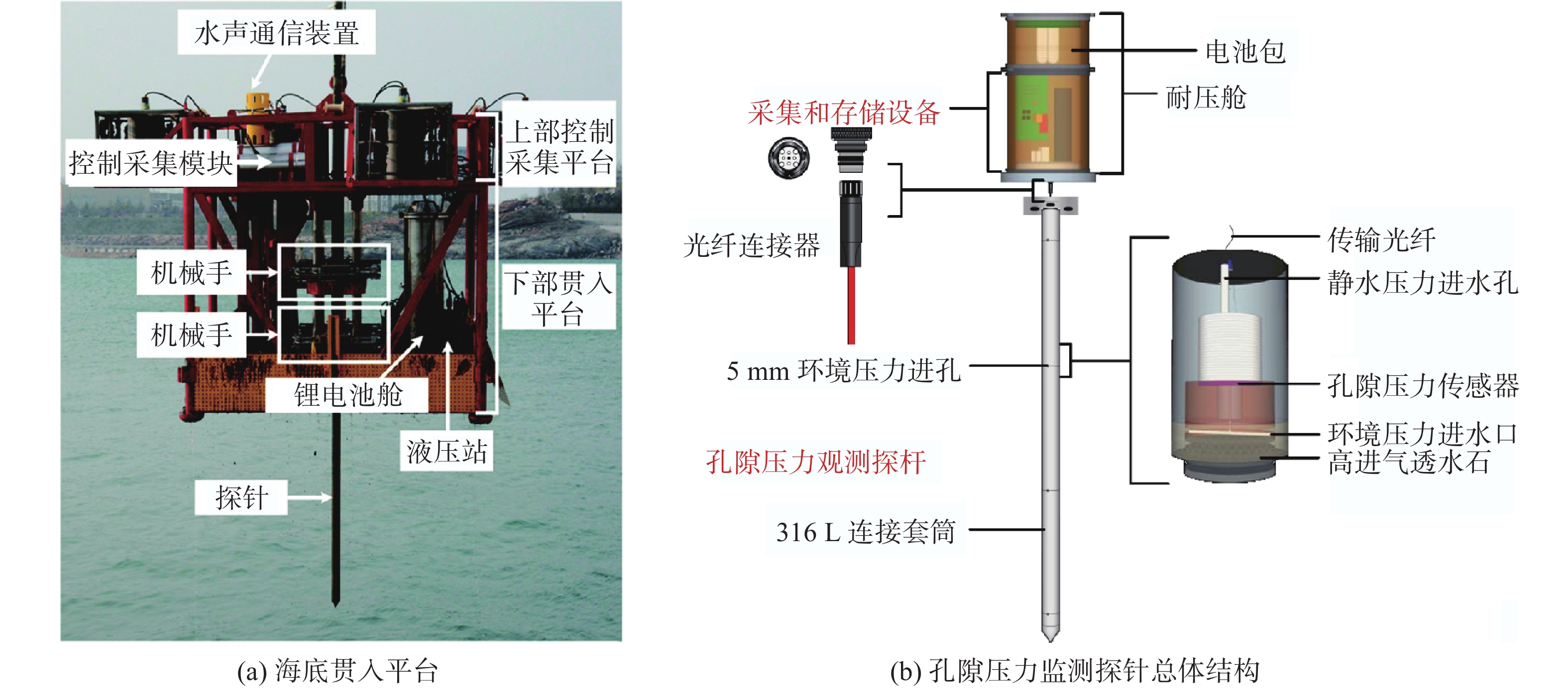
图 3 法国IFREMER Piezometer V2孔隙压力探针监测系统
Figure 3. France IFREMER Piezometer V2 pore-pressure monitoring system
![]()
图 4 中国海洋大学SEEGeo孔隙压力监测系统
Figure 4. SEEGeo pore-pressure monitoring system of Ocean University of China
![]()
![]()
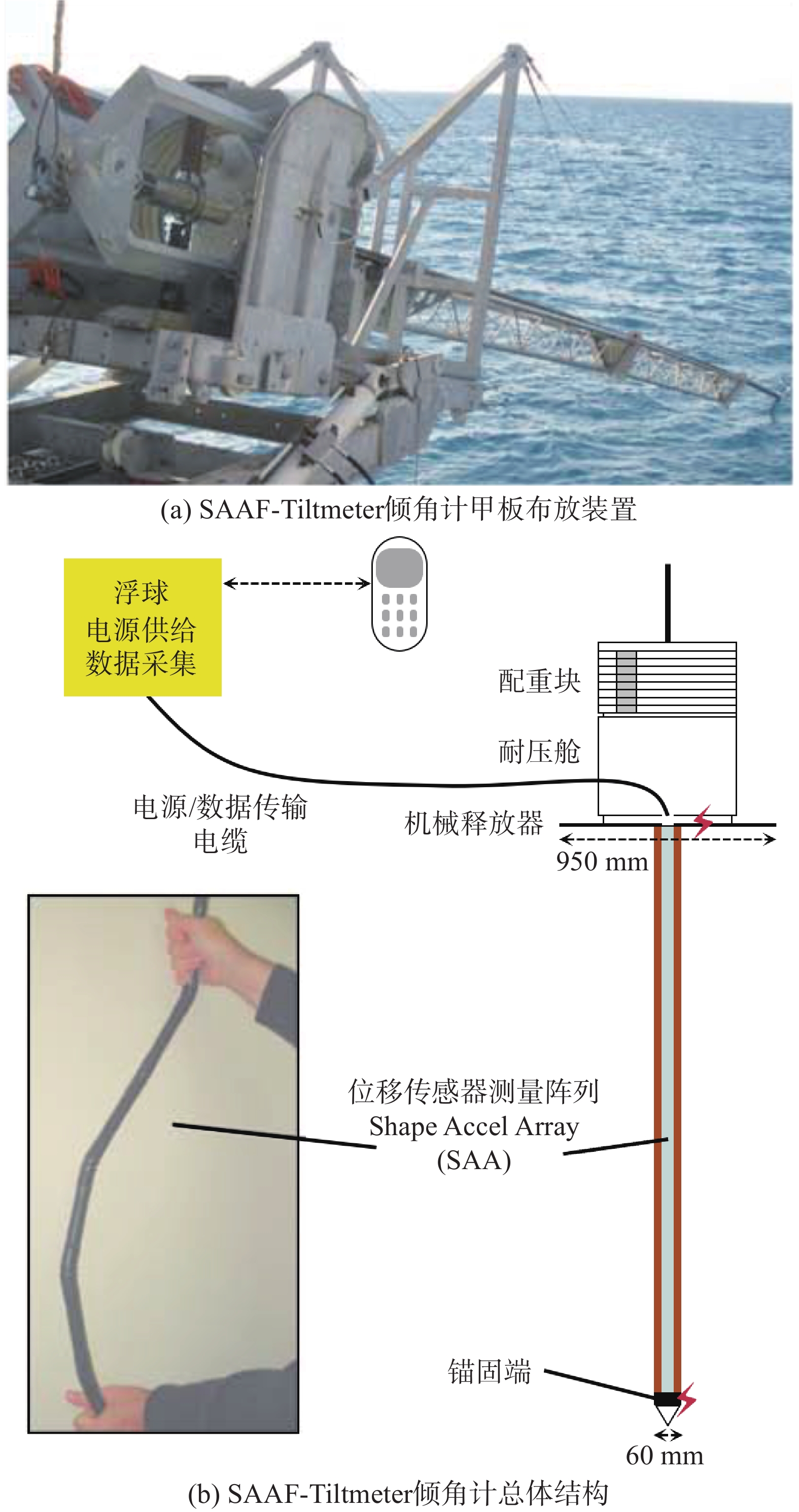
图 6 中国海洋大学海底变形滑动原位实时自动观测装备[46]
Figure 6. In-situ real-time automatic observation equipment for submarine deformation sliding of Ocean University of China
![]()
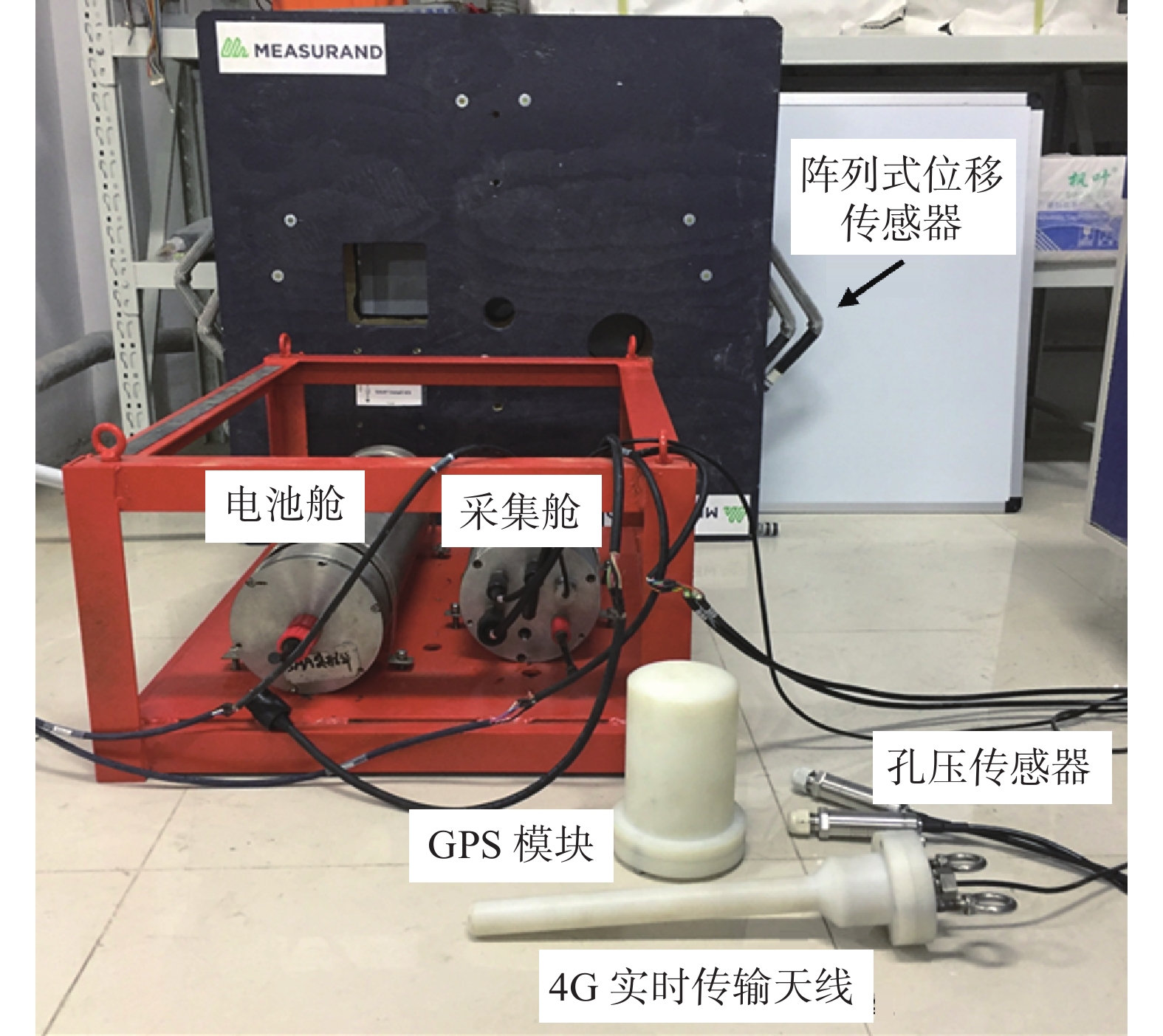
图 7 中国海洋大学海底侵蚀淤积监测装备
Figure 7. Ocean University of China submarine erosion and siltation monitoring equipment
表 1 海洋地质灾害的原位监测要素及监测技术
Table 1 Main in-situ monitoring elements and monitoring technology of marine geohazard
监测要素 监测内容 监测技术 监测指标 致灾因素 内动力地质作用(地震作用、构造运动、
岩浆作用等)海底地震仪OBS、海底热流探针等 记录天然地震事件和人工地震勘探、
温度梯度和热导系数等外动力地质作用(流体动力作用、大气
动力作用、沉积动力作用等)声学多普勒流速仪、波潮仪、大气遥感探测、气象卫星探测等 流速、流向、波浪、潮汐、大气风暴等 内部应力 孔隙压力、温度 孔隙压力探针、温度传感器等 孔隙压力、温度 外部变形 垂向变形 压力传感器、加速度传感器、倾角计等 变形量、变形速率、加速度、倾角等 侧向变形 压力传感器、加速度传感器、倾角计、声学应答器、光纤应变传感器等 变形量、变形速率、加速度、倾角等 地形地貌 数字图像声呐、电阻率探针、自然电位探针、压力传感器等 海床侵蚀淤积量、地形地貌变化等 灾前征兆 内部应力、外部变形等灾前征兆信息 内部应力及外部变形等要素的相关监测技术 孔隙压力累积、外部变形加速等灾前
异常征兆信息 下载: 导出CSV
-
[1] HUGO G. Future demographic change and its interactions with migration and climate change[J]. Global Environmental Change,2011,21:S21 − S33. DOI: 10.1016/j.gloenvcha.2011.09.008
[2] CAMARGO J, SILVA M, FERREIRA A J, et al. Marine geohazards: A bibliometric-based review[J]. Geosciences,2019,9(2):1 − 37.
[3] OECD. The Ocean Economy in 2030[M]. Paris: OECD Publishing, 2016.
[4] ZANIBONI F, ARMIGLIATO A, ELSEN K, et al. The 1977 Gioia Tauro Harbour (South Tyrrhenian Sea, Italy) Landslide-Tsunami: Numerical Simulation[C]//SASSA K, CANUTI P, YIN Y P. Landslide Science for a Safer Geoenvironment. Switzerland: Springer International Publishing, 2014: 589-594.
[5] ASSIER-RZADKIEAICZ S, HEINRICH P, SABATIER P C, et al. Numerical modelling of a landslide-generated tsunami: the 1979 nice event[J]. Pure and Applied Geophysics,2000,157(10):1707 − 1727. DOI: 10.1007/PL00001057
[6] SAHAL A, LEMAHIEU A. The 1979 nice airport tsunami: mapping of the flood in Antibes[J]. Natural Hazards,2011,56(3):833 − 840. DOI: 10.1007/s11069-010-9594-6
[7] NOTTINGHAM P. Review of the 1994 Skagway, Akaska tsunami and future plans[J]. Science of Tsunami Hazards,2002,20(1):42 − 49.
[8] MENKE W, ABEND H, BACH D, et al. Review of the source characteristics of the Great Sumatra–Andaman Islands earthquake of 2004[J]. Surveys in Geophysics,2006,27(6):603 − 613. DOI: 10.1007/s10712-006-9013-4
[9] SULTAN N, CATTANEO A, SIBUET J C, et al. Deep sea in situ excess pore pressure and sediment deformation off NW Sumatra and its relation with the December 26, 2004 Great Sumatra-Andaman Earthquake[J]. International Journal of Earth Sciences,2009,98(4):823 − 837. DOI: 10.1007/s00531-008-0334-z
[10] MAHANEY W C, DOHM J M. The 2011 Japanese 9.0 magnitude earthquake: Test of a kinetic energy wave model using coastal configuration and offshore gradient of Earth and beyond[J]. Sedimentary Geology,2011,239(1/2):80 − 86.
[11] NORIO O, YE T, KAJITANI Y, et al. The 2011 eastern Japan great earthquake disaster: Overview and comments[J]. International Journal of Disaster Risk Science,2011,2(1):34 − 42. DOI: 10.1007/s13753-011-0004-9
[12] FRITZ H M, PHILLIPS D A, OKAYASU A, et al. The 2011 Japan tsunami current velocity measurements from survivor videos at Kesennuma Bay using LiDAR[J]. Geophysical Research Letters,2012,39(7):1 − 6.
[13] 王淼, 马迎晨, 陈洋. 汤加火山喷发搅动半个地球[N]. 北京: 环球时报, 2022 WANG Miao, MA Yingcheng, CHEN Yang. Tonga's volcanic eruption stirs half the world[N]. Beijing: Global Times, 2022. (in Chinese)
[14] CRED, UNISDR. Economic Losses, Poverty & Disasters: 1998-2017[R]. Belgium: CRED&UNISDR Publishing, 2018.
[15] MIZUTORI M, GUHA-SAPIR D. Human cost of disasters: An overview of the last 20 years 2000—2019[R]. Belgium: CRED&UNDRR Publishing, 2020.
[16] ERCILLA G, CASAS D, ALONSO B, et al. Offshore geological hazards: charting the course of progress and future directions[J]. Oceans,2021,2(2):393 − 428. DOI: 10.3390/oceans2020023
[17] KOPP H, CHIOCCI F L, BERNDT C, et al. Marine geohazards: Safeguarding society and the blue economy from a hidden threat[R]. Belgium: European Marine Board Publishing, 2021.
[18] POUDEROUX H, LAMARCHE G, PROUST J N. Building an 18000-year-long paleo-earthquake record from detailed deep-sea turbidite characterisation in Poverty Bay, New Zealand[J]. Natural Hazards and Earth System Sciences,2012,12(6):2077 − 2101. DOI: 10.5194/nhess-12-2077-2012
[19] POLONIA A, VAIANI S C, DE LANGE G J. Did the A. D. 365 Crete earthquake/tsunami trigger synchronous giant turbidity currents in the Mediterranean Sea?[J]. Geology,2016,44(3):191 − 194. DOI: 10.1130/G37486.1
[20] IKEHARA K, KANAMATSU T, NAGAHASHI Y, et al. Documenting large earthquakes similar to the 2011 Tohoku-Oki earthquake from sediments deposited in the Japan Trench over the past 1500 years[J]. Earth and Planetary Science Letters,2016,445:48 − 56. DOI: 10.1016/j.jpgl.2016.04.009
[21] GOLDFINGER C, GALER S, BEESON J, et al. The importance of site selection, sediment supply, and hydrodynamics: A case study of submarine paleoseismology on the northern Cascadia margin, Washington USA[J]. Marine Geology,2017,384:4 − 46. DOI: 10.1016/j.margeo.2016.06.008
[22] ARMIJO R, PONDARD N, MEYER B, et al. Submarine fault scarps in the Sea of Marmara pull-apart (North Anatolian Fault): Implications for seismic hazard in Istanbul[J]. Geochemistry, Geophysics, Geosystems,2005,6(6):1 − 29.
[23] GASPERINI L, POLONIA A, ÇAĞATAY M N, et al. Geological slip rates along the North Anatolian Fault in the Marmara region[J]. Tectonics,2011,30(TC6001):1 − 14.
[24] ÇAĞATAY M N, EREL L, BELLUCCI L G, et al. Sedimentary earthquake records in the İzmit Gulf, Sea of Marmara, Turkey[J]. Sedimentary Geology,2012,282:347 − 359. DOI: 10.1016/j.sedgeo.2012.10.001
[25] YAKUPOĞLU N, UÇARKUŞ G, ERIŞ K K, et al. Sedimentological and geochemical evidence for seismoturbidite generation in the Kumburgaz Basin, Sea of Marmara: Implications for earthquake recurrence along the Central High Segment of the North Anatolian Fault[J]. Sedimentary Geology,2019,380:31 − 44. DOI: 10.1016/j.sedgeo.2018.11.002
[26] KELLER J, RYAN W B F, NINKOVICH D, et al. Explosive volcanic activity in the Mediterranean over the past 200, 000 yr as recorded in deep-sea sediments[J]. Geological Society of America Bulletin,1978,89(4):591 − 604. DOI: 10.1130/0016-7606(1978)89<591:EVAITM>2.0.CO;2
[27] WULF S, KRAML M, KELLER J. Towards a detailed distal tephrostratigraphy in the Central Mediterranean: The last 20, 000 yrs record of Lago Grande di Monticchio[J]. Journal of Volcanology and Geothermal Research,2008,177(1):118 − 132. DOI: 10.1016/j.jvolgeores.2007.10.009
[28] NOMIKOU P, PAPANIKOLAOU D, ALEXANDRI M, et al. Submarine volcanoes along the Aegean volcanic arc[J]. Tectonophysics,2013,597/598:123 − 146. DOI: 10.1016/j.tecto.2012.10.001
[29] 冯志强, 刘宗惠, 柯胜边. 南海北部地质灾害类型及分布规律[J]. 中国地质灾害与防治学报, 1994, 5(增刊1): 171 − 180 FENG Zhiqiang, LIU Zonghui, KE Shengbian. The type, character and distribution law of geological hazard in the north Nanhai Sea[J]. The Chinese Journal of Geological Hazard and Control, 1994, 5(Sup 1): 171 − 180. (in Chinese with English abstract)
[30] 王运兴, 梁收运. 突发性地质灾害研究现状[J]. 世界科技研究与发展,2012,34(1):84 − 88. [WANG Yunxing, LIANG Shouyun. Review of abrupt geological disasters[J]. World Sci-Tech R$D,2012,34(1):84 − 88. (in Chinese with English abstract) WANG Yunxing, LIANG Shouyun. Review of abrupt geological disasters[J]. World Sci-Tech R$D, 2012, 34(1): 84-88. (in Chinese with English abstract)
[31] 洪海粟, 周建钰. 海洋地质灾害的类型、特征与研究趋势[J]. 海洋地质动态,1998,14(7):1 − 4. [WANG Haisu, ZHOU Jianyu. Types, characteristics and research trends of marine geohazards[J]. Marine Geology Frontiers,1998,14(7):1 − 4. (in Chinese) WANG Haisu, ZHOU Jianyu. Types, characteristics and research trends of marine geohazards[J]. Marine Geology Frontiers, 1998, 14(7): 1-4. (in Chinese)
[32] 叶银灿. 海洋灾害地质学发展的历史回顾及前景展望[J]. 海洋学研究,2011,29(4):1 − 7. [YE Yincan. Review of the development of marine hazard geology and its future prospects[J]. Journal of Marine Sciences,2011,29(4):1 − 7. (in Chinese with English abstract) YE Yincan. Review of the development of marine hazard geology and its future prospects[J]. Journal of Marine Sciences, 2011, 29(4): 1-7. (in Chinese with English abstract)
[33] 赵广涛, 谭肖杰, 李德平. 海洋地质灾害研究进展[J]. 海洋湖沼通报,2011(1):159 − 164. [ZHAO Guangtao, TAN Xiaojie, LI Deping. Research and advances in marine geo-hazards[J]. Transactions of Oceanology and Limnology,2011(1):159 − 164. (in Chinese with English abstract) ZHAO Guangtao, TAN Xiaojie, LI Deping. Research and advances in marine geo-hazards[J]. Transactions of Oceanology and Limnology, 2011(1): 159-164. (in Chinese with English abstract)
[34] 韩金良, 吴树仁, 汪华斌. 地质灾害链[J]. 地学前缘,2007,14(6):11 − 23. [HAN Jinliang, WU Shuren, WANG Huabin. Preliminary study on geological hazard chains[J]. Earth Science Frontiers,2007,14(6):11 − 23. (in Chinese with English abstract) DOI: 10.1016/S1872-5791(08)60001-9 HAN Jinliang, WU Shuren, WANG Huabin. Preliminary study on geological hazard chains[J]. Earth Science Frontiers, 2007, 14(6): 11-23. (in Chinese with English abstract) DOI: 10.1016/S1872-5791(08)60001-9
[35] 朱兴华, 彭建兵, 同霄, 等. 黄土地区地质灾害链研究初探[J]. 工程地质学报,2017,25(1):117 − 122. [ZHU Xinghua, PENG Jianbing, TONG Xiao, et al. Preliminary research on geological disaster chains in loess area[J]. Journal of Engineering Geology,2017,25(1):117 − 122. (in Chinese with English abstract) ZHU Xinghua, PENG Jianbing, TONG Xiao, et al. Preliminary research on geological disaster chains in loess area[J]. Journal of Engineering Geology, 2017, 25(1): 117-122. (in Chinese with English abstract)
[36] TAPPIN D R. Tsunamis from submarine landslides[J]. Geology Today,2017,33(5):190 − 200. DOI: 10.1111/gto.12200
[37] PINO N A, PIATANESI A, VALENSISE G, et al. The 28 December 1908 Messina Straits earthquake (MW 7.1): A great earthquake throughout a century of seismology[J]. Seismological Research Letters,2009,80(2):243 − 259. DOI: 10.1785/gssrl.80.2.243
[38] HASEGAWA A, OHIRA T, MAEDA M, et al. Emergency responses and health consequences after the Fukushima accident; evacuation and relocation[J]. Clinical Oncology,2016,28(4):237 − 244. DOI: 10.1016/j.clon.2016.01.002
[39] LIPSCY P Y, KUSHIDA K E, INCERTI T. The Fukushima disaster and Japan's nuclear plant vulnerability in comparative perspective[J]. Environmental Science & Technology,2013,47(12):6082 − 6088.
[40] COLANTONI P, GENNESSEAUX M, VANNEY J R, et al. Dynamic processes of a submarine canyon of Gioia Tauro, Tyrrhenian Sea[J]. Giornale Di Geologia,1992,54(2):199 − 213.
[41] DANIELL J E, SCHAEFER A M, WENZEL F. Losses associated with secondary effects in earthquakes[J]. Frontiers in Built Environment,2017,3(30):1 − 14.
[42] CUTTER S L. Compound, cascading, or complex disasters: what's in a name?[J]. Environment:Science and Policy for Sustainable Development,2018,60(6):16 − 25. DOI: 10.1080/00139157.2018.1517518
[43] RYAN W B F, HEEZEN B C. Ionian Sea submarine canyons and the 1908 Messina turbidity current[J]. Geological Society of America Bulletin,1965,76:915 − 932. DOI: 10.1130/0016-7606(1965)76[915:ISSCAT]2.0.CO;2
[44] CATTANEO A, BABONNEAU N, RATZOV G, et al. Searching for the seafloor signature of the 21 May 2003 Boumerdès earthquake offshore central Algeria[J]. Natural Hazards and Earth System Sciences,2012,12(7):2159 − 2172. DOI: 10.5194/nhess-12-2159-2012
[45] 董月娥, 左书华. 1989年以来我国海洋灾害类型、危害及特征分析[J]. 海洋地质动态,2009,25(6):28 − 33. [DONG Yuee, ZUOShuhua. Analysis of the types, hazards and characteristics of marine disasters in China since 1989[J]. Marine Geology Frontiers,2009,25(6):28 − 33. (in Chinese with English abstract) DONG Yuee, ZUOShuhua. Analysis of the types, hazards and characteristics of marine disasters in China since 1989[J]. Marine Geology Frontiers, 2009, 25(6): 28-33. (in Chinese with English abstract)
[46] 许强. 对滑坡监测预警相关问题的认识与思考[J]. 工程地质学报,2020,28(2):360 − 374. [XU Qiang. Understanding the landslide monitoring and early warning: consideration to practical issues[J]. Journal of Engineering Geology,2020,28(2):360 − 374. (in Chinese with English abstract) XU Qiang. Understanding the landslide monitoring and early warning: consideration to practical issues[J]. Journal of Engineering Geology, 2020, 28(2): 360-374. (in Chinese with English abstract)
[47] SCHULTHEISS P J. Pore pressures in marine sediments: an overview of measurement techniques and some geological and engineering applications[J]. Marine Geophysical Researches,1990,12(1/2):153 − 168.
[48] 贾永刚, 王振豪, 刘晓磊, 等. 海底滑坡现场调查及原位观测方法研究进展[J]. 中国海洋大学学报(自然科学版),2017,47(10):61 − 72. [JIA Yonggang, WANG Zhenhao, LIU Xiaolei, et al. The research progress of field investigation and in-situ observation methods for submarine landslide[J]. Periodical of Ocean University of China,2017,47(10):61 − 72. (in Chinese with English abstract) JIA Yonggang, WANG Zhenhao, LIU Xiaolei, et al. The research progress of field investigation and in situ observation methods for submarine landslide[J]. Periodical of Ocean University of China, 2017, 47(10): 61-72. (in Chinese with English abstract)
[49] PRIOR D B, SUHAYDA J N, LU N Z, et al. Storm wave reactivation of a submarine landslide[J]. Nature,1989,341(6237):47 − 50. DOI: 10.1038/341047a0
[50] FAVALI P, BERANZOLI L. Seafloor observatory science: A review[J]. Annals of Geophysics,2009,49(2/3):515 − 567.
[51] 阮爱国, 李家彪, 冯占英, 等. 海底地震仪及其国内外发展现状[J]. 东海海洋,2004,22(2):19 − 27. [RUAN Aiguo, LI Jiabiao, FENG Zhanying, et al. Ocean bottom seismometer and its development in the world[J]. Donghai Marine Science,2004,22(2):19 − 27. (in Chinese with English abstract) RUAN Aiguo, LI Jiabiao, FENG Zhanying, et al. Ocean bottom seismometer and its development in the world[J]. Donghai Marine Science, 2004, 22(2): 19-27. (in Chinese with English abstract)
[52] KOPP H, WEINZIERL W, BECEL A, et al. Deep structure of the central Lesser Antilles Island Arc: relevance for the formation of continental crust[J]. Earth and Planetary Science Letters,2011,304(1/2):121 − 134.
[53] SALLARÈS V, MARTÍNEZ-LORIENTE S, PRADA M, et al. Seismic evidence of exhumed mantle rock basement at the Gorringe Bank and the adjacent Horseshoe and Tagus abyssal Plains (SW Iberia)[J]. Earth and Planetary Science Letters,2013,365:120 − 131. DOI: 10.1016/j.jpgl.2013.01.021
[54] 牛雄伟, 阮爱国, 吴振利, 等. 海底地震仪实用技术探讨[J]. 地球物理学进展,2014,29(3):1418 − 1425. [NIU Xiongwei, RUAN Aiguo, WU Zhenli, et al. Progress on practical skills of Ocean Bottom Seismometer(OBS) experiment[J]. Progress in Geophysics,2014,29(3):1418 − 1425. (in Chinese with English abstract) NIU Xiongwei, RUAN Aiguo, WU Zhenli, et al. Progress on practical skills of Ocean Bottom Seismometer(OBS) experiment[J]. Progress in Geophysics, 2014, 29(3): 1418-1425. (in Chinese with English abstract)
[55] 余本善, 孙乃达. 海底地震采集技术发展现状及建议[J]. 海洋石油,2015,35(2):1 − 5. [YU Benshan, SUN Naida. Current development situations and suggestion on the techniques of ocean bottom seismic acquisition[J]. Offshore Oil,2015,35(2):1 − 5. (in Chinese with English abstract) YU Benshan, SUN Naida. Current development situations and suggestion on the techniques of ocean bottom seismic acquisition[J]. Offshore Oil, 2015, 35(2): 1-5. (in Chinese with English abstract)
[56] 郝天珧, 游庆瑜. 国产海底地震仪研制现状及其在海底结构探测中的应用[J]. 地球物理学报,2011,54(12):3352 − 3361. [HAO Tianyao, YOU Qingyu. Progress of homemade OBS and its application on ocean bottom structure survey[J]. Chinese Journal of Geophysics,2011,54(12):3352 − 3361. (in Chinese with English abstract) HAO Tianyao, YOU Qingyu. Progress of homemade OBS and its application on ocean bottom structure survey[J]. Chinese Journal of Geophysics, 2011, 54(12): 3352-3361. (in Chinese with English abstract)
[57] PAPOULIA J, MAKRIS J, KOULAKOV I, et al. Microseismicity and Crustal Deformation of the Dodecanese Volcanic Area, Southeastern Aegean Sea Using an Onshore/Offshore Seismic Array[J]. Bollettino di Geofisica Teorica ed Applicata,2018,55(2):281 − 302.
[58] GOHL K. Structure and dynamics of a submarine continent: Tectonic-magmatic evolution of the Campbell Plateau (New Zealand)[R]. Report of the RV SONNE cruise SO-169, Germany: Alfred-Wegener-Institut für Polar-und Meeresforschung, 2003.
[59] WALLACE L M, ARAKI E, SAFFER D, et al. Near-field observations of an offshore Mw 6.0 earthquake from an integrated seafloor and subseafloor monitoring network at the Nankai Trough, southwest Japan[J]. Journal of Geophysical Research:Solid Earth,2016,121(11):8338 − 8351. DOI: 10.1002/2016JB013417
[60] 吕枫, 周怀阳. 缆系海底科学观测网研究进展[J]. 工程研究-跨学科视野中的工程,2016,8(2):139 − 154. [LYU Feng, ZHOU Huaiyang. Progress of scientific cabled seafloor observatory networks[J]. Journal of Engineering Studies,2016,8(2):139 − 154. (in Chinese with English abstract) LYU Feng, ZHOU Huaiyang. Progress of scientific cabled seafloor observatory networks[J]. Journal of Engineering Studies, 2016, 8(2): 139-154. (in Chinese with English abstract)
[61] 申中寅. 日本海洋实时监测系统DONET简介[J]. 国际地震动态,2018,48(7):34 − 40. [SHEN Zhongyin. A brief introduction to DONET in Japan[J]. Recent Developments in World Seismology,2018,48(7):34 − 40. (in Chinese with English abstract) SHEN Zhongyin. A brief introduction to DONET in Japan[J]. Recent Developments in World Seismology, 2018, 48(7): 34-40. (in Chinese with English abstract)
[62] MULIA I E, SATAKE K. Correction to: Synthetic analysis of the efficacy of the S-net system in tsunami forecasting[J]. Earth, Planets and Space,2021,73(36):1 − 11.
[63] 张文涛, 黄稳柱. 光纤海底地震仪的研制与应用探索[C]//中国地球物理学会国家安全地球物理专业委员会, 陕西省地球物理学会军事地球物理专业委员会. 国家安全地球物理丛书(十四)—资源·环境与地球物理. 西安: 西安地图出版社, 2018: 296 − 300 ZHANG Wentao, HUANG Wenzhu. Development of fiber optic ocean bottom seismograph[C]//National Security Geophysics Committee of the Chinese Geophysical Society, Military Geophysics Committee of the Geophysical Society of Shaanxi Province. National Security Geophysics Series (XIV)—Resources·Environment and Geophysics. Xi’an: Xi’an Map Press, 2018: 296 − 300. (in Chinese with English abstract)
[64] MARRA G, CLIVATI C, LUCKETT R, et al. Ultrastable laser interferometry for earthquake detection with terrestrial and submarine cables[J]. Science,2018,361(6401):486 − 490. DOI: 10.1126/science.aat4458
[65] JOUSSET P, REINSCH T, RYBERG T, et al. Dynamic strain determination using fibre-optic cables allows imaging of seismological and structural features[J]. Nature Communications,2018,9:2509. DOI: 10.1038/s41467-018-04860-y
[66] SLADEN A, RIVET D, AMPUERO J P, et al. Distributed sensing of earthquakes and ocean-solid Earth interactions on seafloor telecom cables[J]. Nature Communications,2019,10:5777. DOI: 10.1038/s41467-019-13793-z
[67] HOWE B M, ARBIC B K, AUCAN J, et al. SMART cables for observing the global ocean: science and implementation[J]. Frontiers in Marine Science,2019,6:424. DOI: 10.3389/fmars.2019.00424
[68] 陈天, 贾永刚, 刘涛, 等. 海底沉积物孔隙压力原位长期观测技术回顾和展望[J/OL]. 地学前缘, 2022. https://doi.org/10.13745/j.esf.sf.2021.9.30. CHEN Tian, JIA Yonggang, LIU Tao, et al. Review and prospects of in-situ long term pore-pressures observation in marine sediments[J/OL]. Earth Science Frontiers: 1 − 16, 2022. https://doi.org/10.13745/j.esf.sf.2021.9.30. (in Chinese with English abstract)
[69] SULTAN N, SAVOYE B, JOUET G, et al. Investigation of a possible submarine landslide at the Var delta front (Nice continental slope, southeast France)[J]. Canadian Geotechnical Journal,2010,47(4):486 − 496. DOI: 10.1139/T09-105
[70] STEGMANN S, SULTAN N, KOPF A, et al. Hydrogeology and its effect on slope stability along the coastal aquifer of Nice, France[J]. Marine Geology,2011,280(1/2/3/4):168 − 181.
[71] STEGMANN S, SULTAN N, GARZIGLIA S, et al. A long-term monitoring array for landslide precursors: a case study at the Ligurian slope (western Mediterranean Sea)[C]//All Days. April 30-May 3, 2012. Houston, Texas, USA. OTC, 2012: 1 − 10.
[72] SULTAN N, GARZIGLIA S, BOMPAIS X, et al. Transient groundwater flow through a coastal confined aquifer and its impact on nearshore submarine slope instability[J]. Journal of Geophysical Research: Earth Surface,2020,125(9):e2020JF005654.
[73] LIU T, WEI G L, KOU H L, et al. Pore pressure observation: pressure response of probe penetration and tides[J]. Acta Oceanologica Sinica,2019,38(7):107 − 113. DOI: 10.1007/s13131-019-1462-4
[74] LIU T, LI S P, KOU H L, et al. Excess pore pressure observation in marine sediment based on Fiber Bragg Grating pressure sensor[J]. Marine Georesources & Geotechnology,2019,37(7):775 − 782.
[75] STENVOLD T, EIKEN O, ZUMBERGE M A, et al. High-precision relative depth and subsidence mapping from seafloor water-pressure measurements[J]. SPE Journal,2006,11(3):380 − 389. DOI: 10.2118/97752-PA
[76] YOKOYAMA T, SHIMOYAMA M, MATSUDA S, et al. Monitoring system of seafloor subsidence for methane hydrate production test[C]//Society of Petrophysicists and Well-Log Analysts. 18th Formation Evaluation Symposium of Japan 2012. Japan: Society of Petrophysicists and Well-Log Analysts, 2012.
[77] YOKOYAMA T, SHIMOYAMA M, MATSUDA S, et al. Monitoring system for seafloor deformation during Methane Hydrate production test[C]//International Society of Offshore and Polar Engineers. Proceedings of the 10th (2013) ISOPE Ocean Mining and Gas Hydrates Symposium, ISOPE OMS 2013. Poland: Society of Petrophysicists and Well-Log Analysts, 2013: 132 − 135.
[78] CHADWICK W W, NOONER S L, BUTTERFIELD D A, et al. Seafloor deformation and forecasts of the April 2011 eruption at Axial Seamount[J]. Nature Geoscience,2012,5(7):474 − 477. DOI: 10.1038/ngeo1464
[79] ZUMBERGE M A. Precise optical path length measurement through an optical fiber: Application to seafloor strain monitoring[J]. Ocean Engineering,1997,24(6):531 − 542. DOI: 10.1016/S0029-8018(96)00029-7
[80] WANG Z H, SUN Y F, JIA Y G, et al. Wave-induced seafloor instabilities in the subaqueous Yellow River Delta—initiation and process of sediment failure[J]. Landslides,2020,17(8):1849 − 1862. DOI: 10.1007/s10346-020-01399-2
[81] SAITO H, YOKOYAMA T, UCHIYAMA S. Seafloor stability monitoring by displacements calculated from acceleration waveforms obtained by a 3-component servo-accelerometer system[C]//OCEANS 2006. September 18-21, 2006, Boston, MA, USA. IEEE, 2006: 1 − 6.
[82] FABIAN M, VILLINGER H. The Bremen Ocean bottom tiltmeter (OBT)–A technical article on a new instrument to monitor deep sea floor deformation and seismicity level[J]. Marine Geophysical Researches,2007,28(1):13 − 26. DOI: 10.1007/s11001-006-9011-4
[83] FABIAN M, VILLINGER H. Long-term tilt and acceleration data from the Logatchev Hydrothermal Vent Field, Mid-Atlantic Ridge, measured by the Bremen Ocean Bottom Tiltmeter[J]. Geochemistry, Geophysics, Geosystems,2008,9(7):488 − 498.
[84] PETERSEN F, KOPP H, LANGE D, et al. Measuring tectonic seafloor deformation and strain-build up with acoustic direct-path ranging[J]. Journal of Geodynamics,2019,124:14 − 24. DOI: 10.1016/j.jog.2019.01.002
[85] YOKOTA Y, ISHIKAWA T, WATANABE S I. Seafloor crustal deformation data along the subduction zones around Japan obtained by GNSS-A observations[J]. Scientific Data,2018,5:180182. DOI: 10.1038/sdata.2018.182
[86] EISMA D. Suspended matter in the aquatic environment[M]. Berlin: Springer, 1993: 1-8.
[87] WREN D G, BARKDOLL B D, KUHNLE R A, et al. Field techniques for suspended-sediment measurement[J]. Journal of Hydraulic Engineering,2000,126(2):97 − 104. DOI: 10.1061/(ASCE)0733-9429(2000)126:2(97)
[88] 郭磊. 海底边界层原位综合观测系统研发与应用研究[D]. 青岛: 中国海洋大学, 2016 GUO Lei. Research and application of in-situ integrated observation system for seabed boundary layer [D]. Qingdao: Ocean University of China, 2016. (in Chinese with English abstract)
[89] TRAYKOVSKI P, HAY A E, IRISH J D, et al. Geometry, migration, and evolution of wave orbital ripples at LEO-15[J]. Journal of Geophysical Research: Oceans,1999,104(C1):1505 − 1524. DOI: 10.1029/1998JC900026
[90] 季春生, 贾永刚, 朱俊江, 等. 海底沉积物孔隙压力原位长期观测技术回顾和展望[J/OL]. 地学前缘, 2022. https://doi.org/10.13745/j.esf.sf.2021.9.28. JI Chunsheng, JIA Yonggang, ZHU Junjiang, et al. Development and application of in-situ observation system for bottom boundary layer in abyssal sea[J/OL]. Earth Science Frontiers, 2022. https://doi.org/10.13745/j.esf.sf.2021.9.28. (in Chinese with English abstract)
[91] DAVIS A M. Methane in marine sediments[J]. Continental Shelf Research,1992,12(10):1075 − 1264. DOI: 10.1016/0278-4343(92)90068-U
[92] 杨肖迪, 马瑞民, 罗小桥, 等. 海底浅层气探测识别方法研究[J]. 海岸工程,2020,39(3):187 − 195. [YANG Xiaodi, MA Ruimin, LUO Xiaoqiao, et al. Study on the methods for detection and identification of sub-seabed shallow gases[J]. Coastal Engineering,2020,39(3):187 − 195. (in Chinese with English abstract) YANG Xiaodi, MA Ruimin, LUO Xiaoqiao, et al. Study on the methods for detection and identification of sub-seabed shallow gases[J]. Coastal Engineering, 2020, 39(3): 187-195. (in Chinese with English abstract)
[93] 任子茵, 郭秀军, 吴景鑫. 浅水条件下浅层气走航式海洋电阻率法探测结果模拟分析[J]. 中国海洋大学学报(自然科学版),2019,49(7):56 − 63. [REN Ziyin, GUO Xiujun, WU Jingxin. Simulationand analysis of detection results of shallow gas under shallow water with a navigated DC marine resistivity method[J]. Periodical of Ocean University of China,2019,49(7):56 − 63. (in Chinese with English abstract) REN Ziyin, GUO Xiujun, WU Jingxin. Simulationand analysis of detection results of shallow gas under shallow water with a navigated DC marine resistivity method[J]. Periodical of Ocean University of China, 2019, 49(7): 56-63. (in Chinese with English abstract)
[94] 孙翔, 郭秀军, 吴景鑫. 海底砂土中气体运移过程电阻率监测探针设计与实验[J]. 海洋学报,2020,42(5):139 − 149. [SUN Xiang, GUO Xiujun, WU Jingxin. Design and experiment of resistivity monitoring probe for gas migration in marine sand[J]. Acta Oceanologica Sinica,2020,42(5):139 − 149. (in Chinese with English abstract) SUN Xiang, GUO Xiujun, WU Jingxin. Design and experiment of resistivity monitoring probe for gas migration in marine sand[J]. Acta Oceanologica Sinica, 2020, 42(5): 139-149. (in Chinese with English abstract)
[95] COWEN J P, COPSON D A, JOLLY J, et al. Advanced instrument system for real-time and time-series microbial geochemical sampling of the deep (basaltic) crustal biosphere[J]. Deep Sea Research Part I: Oceanographic Research Papers,2012,61:43 − 56. DOI: 10.1016/j.dsr.2011.11.004
[96] SOLOMON E, BECKER K, KOPF A, et al. Listening down the pipe[J]. Oceanography,2019,32(1):98 − 101. DOI: 10.5670/oceanog.2019.128
[97] ARAKI E, SAFFER D M, KOPF A J, et al. Recurring and triggered slow-slip events near the trench at the Nankai Trough subduction megathrust[J]. Science,2017,356(6343):1157 − 1160. DOI: 10.1126/science.aan3120
[98] URLAUB M, PETERSEN F, GROSS F, et al. Gravitational collapse of Mount Etna’s southeastern flank[J]. Science Advances,2018,4(10):eaat9700. DOI: 10.1126/sciadv.aat9700
[99] 郭延辉, 杨溢, 杨志全, 等. 国产GB-InSAR在特大型水库滑坡变形监测中的应用[J]. 中国地质灾害与防治学报,2021,32(2):66 − 72. [GUO Yanhui, YANG Yi, YANG Zhiquan, et al. Application of GB-InSAR in deformation monitoring of huge landslide in reservoir area[J]. The Chinese Journal of Geological Hazard and Control,2021,32(2):66 − 72. (in Chinese with English abstract) GUO Yanhui, YANG Yi, YANG Zhiquan, et al. Application of GB-InSAR in deformation monitoring of huge landslide in reservoir area[J]. The Chinese Journal of Geological Hazard and Control, 2021, 32(2): 66-72. (in Chinese with English abstract)
[100] 周小龙, 贾强, 石鹏卿, 等. 免像控无人机航测技术在舟曲县立节北山滑坡-泥石流灾害应急处置中的应用[J]. 中国地质灾害与防治学报,2022,33(1):107 − 116. [ZHOU Xiaolong, JIA Qiang, SHI Pengqing, et al. Application of image-free control UAV aerial survey technology in emergency treatment of landslide-debris flow disaster in Lijie north hill, Zhouqu County[J]. The Chinese Journal of Geological Hazard and Control,2022,33(1):107 − 116. (in Chinese with English abstract) ZHOU Xiaolong, JIA Qiang, SHI Pengqing, et al. Application of image-free control UAV aerial survey technology in emergency treatment of landslide-debris flow disaster in Lijie north hill, Zhouqu County[J]. The Chinese Journal of Geological Hazard and Control, 2022, 33(1): 107-116. (in Chinese with English abstract)
[101] 张欢, 巨能攀, 陆渊, 等. 基于无人机的滑坡地形快速重建与稳定性分析[J]. 水文地质工程地质,2021,48(6):171 − 179. [ZHANG Huan, JU Nengpan, LU Yuan, et al. Rapid remodeling of three-dimensional terrain and stability analyses of landslide based on UAV[J]. Hydrogeology & Engineering Geology,2021,48(6):171 − 179. (in Chinese with English abstract) ZHANG Huan, JU Nengpan, LU Yuan, et al. Rapid remodeling of three-dimensional terrain and stability analyses of landslide based on UAV[J]. Hydrogeology & Engineering Geology, 2021, 48(6): 171-179. (in Chinese with English abstract)
[102] 方然可, 刘艳辉, 苏永超, 等. 基于逻辑回归的四川青川县区域滑坡灾害预警模型[J]. 水文地质工程地质,2021,48(1):181 − 187. [FANG Ranke, LIU Yanhui, SU Yongchao, et al. A early warning model of regional landslide in Qingchuan County, Sichuan Province based on logistic regression[J]. Hydrogeology & Engineering Geology,2021,48(1):181 − 187. (in Chinese with English abstract) FANG Ranke, LIU Yanhui, SU Yongchao, et al. A early warning model of regional landslide in Qingchuan County, Sichuan Province based on logistic regression[J]. Hydrogeology & Engineering Geology, 2021, 48(1): 181-187. (in Chinese with English abstract)
-
期刊类型引用(8)
1. 涂正楠,冯君,邓应进,潘激扬. 四川甘洛县比依市村滑坡运动特征分析. 中国地质灾害与防治学报. 2024(01): 92-99 .  本站查看
本站查看
2. 党杰,杨亮,段方情,范宣梅. 贵州晴隆红寨大型古滑坡复活变形特征及成因分析. 中国地质灾害与防治学报. 2024(04): 25-35 . 本站查看
3. 徐伟,郑玄,欧文,铁永波,付小麟,宋钰朋,殷万清. 四川凉山州地质灾害灾情特征与主要致灾类型. 中国地质灾害与防治学报. 2024(05): 78-89 . 本站查看
4. 马海善,吴瑞安,赵文博,王计博,齐畅,邓盼,李英钧. 西藏山南鲁麦古滑坡发育特征与复活变形机制研究. 中国地质灾害与防治学报. 2024(05): 32-41 . 本站查看
5. 林灿阳. 某古滑坡病害成因与整治措施研究. 路基工程. 2024(06): 205-212 . 百度学术
6. 汪美华,李勇,裴叶青. 甘肃临夏盆地韩集北山滑坡群致灾特征与稳定性评价. 地质通报. 2023(Z1): 460-468 . 百度学术
7. 蒋涛,崔圣华,冉耀. 开挖和降雨耦合诱发滑坡机理分析——以四川万源前进广场滑坡为例. 中国地质灾害与防治学报. 2023(03): 20-30 . 本站查看
8. 赵海松,向波,邵江,魏安辉,邬凯,张磊,柳松. 青岗古滑坡体前缘开挖后局部复活特征及防治. 科技和产业. 2023(16): 263-268 . 百度学术
其他类型引用(0)


计量
- 文章访问数: 716
- HTML全文浏览量: 339
- PDF下载量: 1179
- 被引次数: 8
 邮件订阅
邮件订阅 RSS
RSS