

Distribution and susceptibility assessment of geological hazards in Zemuhe fault zone (Puge section)
-
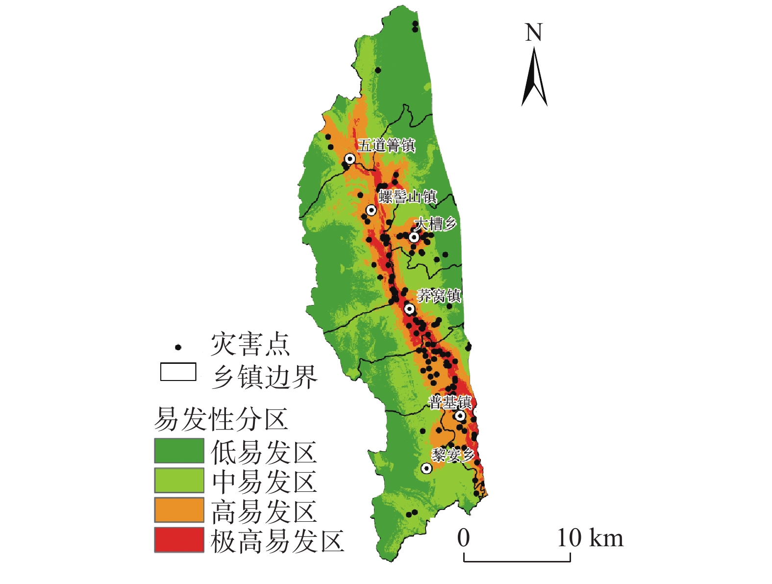
摘要: 以则木河断裂带(普格段)为研究区,分析研究区的地质灾害控制效应以及发育规律;选取海拔高程、坡向、坡度等7个评价因子构建评价指标体系,运用确定性系数模型与信息量模型耦合的加权信息量模型,通过ArcGIS进行地质灾害易发性评价。结果显示,研究区地质灾害发育具有断层距离效应、地层效应以及高程和坡度微地貌效应;极高易发区、高易发区、中易发区和低易发区的面积分别为46.75 km2、123.78 km2、215.73 km2、285.34 km2,面积占比分别为6.96%、18.43%、32.12%、42.49%。研究结果对指导则木河断裂带地区以及同类区域的国土空间规划与地灾防治等方面具有重要现实意义。Abstract: Taking Zemuhe fault zone (Puge section) as the study area, the control effect and development law of geological disasters in the study area are analyzed; Seven evaluation factors such as elevation, aspect and slope from fault are selected to construct the evaluation index system. The weighted information model coupled with deterministic coefficient model and information model is used to evaluate the susceptibility of geological disasters through ArcGIS. The results show that the development of geological hazards in the study area has fault distance effect, elevation and slope micro geomorphic effect and stratigraphic effect;The areas of extremely high, high, medium and low prone areas are 46.75 km2, 123.78 km2, 215.73 km2 and 285.34 km2 respectively, accounting for 6.96%, 18.43%, 32.12% and 42.49% respectively. The research results have important practical significance for guiding the land spatial planning and geological disaster prevention in Zemuhe fault zone and similar regions.
-
0. 引言
我国是地质灾害高发国家之一,各类地质灾害给人们的生命和财产造成了巨大的损失[1]。面对严峻的地质灾害问题,自上个世纪90年代起,我国开展了多轮地质灾害详细调查及排查工作,有力保障了人民群众的生命和财产安全且有助于展开之后的地质灾害调查工作[2],但部分地区地质灾害问题依旧突出。
我国西南地区地形地貌复杂,植被覆盖度较高,区内的地质灾害具有较高的隐蔽性,传统的地质灾害调查方法难以快速、准确的应对,必须借助现代高精度对地观测技术,如高精度光学遥感技术、合成孔径雷达干涉测量技术(Interferometric Synthetic Aperture Radar,In-SAR)等[3]。
卫星光学遥感技术因其时效性好、宏观性强、信息丰富的特点,已成为重大自然灾害调查分析和灾情评估的一种重要手段[4]。20世纪90年代以后,IKONOS(分辨率1 m)、QuickBird(分辨率0.6 m)、WordView2(分辨率0.5 m)等高分辨率的卫星影像被广泛应用于地质灾害探测与监测[5]。王瑞国等[6]依据WordView2卫星数据将解译结果与野外验证相结合、人机交互解译与计算机自动信息提取相结合的方法,圈定了乌东煤矿区域地质灾害点集中发育区。
合成孔径雷达干涉测量技术是近20年发展起来的一门广泛应用于监测自然灾害和人类活动导致的地表环境变化的技术,具有全天候、大范围、高精度、强时效、具有穿透性等特点[7]。刘星洪等[8]基于InSAR对雷波县区域活动性滑坡进行了早期识别;戴可人等[9]基于InSAR对雅砻江中段区域进行了高山峡谷区滑坡灾害隐患的早期识别;杨成生等[10]基于InSAR技术对金沙江结合带巴塘段滑坡群进行了滑坡探测识别。
因此,本文采用WordView2、Sentinel-1、ALOS-2遥感数据,以滇西北地区为研究区,对研究区潜在滑坡或老滑坡进行综合遥感识别,并进行野外验证,分析灾害体的光学影像、InSAR地表变形图的影像及图像特征,灾害体的发育特征,分布规律,并建立光学遥感解译标志、InSAR图像识别标志,总结识别方法,提高滇西北地区滑坡的识别率,为今后滇西北地区滑坡隐患识别、地质灾害调查与评价提供借鉴。
1. 研究区区域地质概况
研究区位于云南省西北部,包含保山、大理、丽江、临沧、怒江、德宏、普洱、迪庆、楚雄、玉溪等10个市(州)46个县(区),总面积约15×104 km2。
1.1 自然地理
滇西北属于喜马拉雅山系东部的横断山脉纵向岭谷区,北接青藏高原,东南与云贵高原相连,西部与缅甸相接。境内地质情况复杂,有高黎贡山、云岭、白马雪山等巨大山系纵贯南北,怒江、澜沧江、金沙江并流其间。
1.2 地形地貌
滇西北地势西北高、东南低,自北向南呈阶梯状逐级下降,从北到南的每千米水平直线距离,海拔平均下降6 m,属山地高原地形。
1.3 气象水文
滇西北属高原山地气候,具有终年低温干燥、夏季凉爽、冬季寒冷的特点。主要表现为:气候的区域差异和垂直变化十分明显,年温差小,日温差大,立体气候特征显著。干湿季节分明,湿季(雨季)为5—10月,集中了85%的降雨量;干季(旱季)为11月至次年4月,降水量只占全年的15%。
1.4 地层岩性
滇西北地区区内地层齐全,元古界、古生界、中生界、新生界均有出露,大部分地层均有不同程度的变质。
1.5 地质构造与地震
区内构造变形复杂,断裂活动强烈,主要的区域性断裂有20多条,将其归为16个大型构造,有:高黎贡山大型逆冲-走滑断裂构造,怒江大型逆冲-走滑断裂构造,勐统—沧源逆冲叠瓦构造等。
2. 遥感数据源与数据处理
2.1 光学数据源
光学数据源主要采用全色0.5 m精度的2018—2020年的WordView2卫星数据。
2.2 InSAR数据源
InSAR数据源主要采用2017—2020年的哨兵-1A(Sentinel-1A)雷达卫星(C波段)SAR数据和ALOS-2雷达卫星(L波段)SAR数据。
2.2.1 哨兵-1A雷达卫星数据
哨兵-1A(Sentinel-1A)是一个全天时、全天候雷达成像系统,由欧洲委员会(EC)和欧洲航天局(ESA)针对哥白尼全球对地观测项目研制的首颗卫星,于2014年10月开始逐步走向应用[11](表1)。
表 1 Sentinel-A雷达数据基本参数Table 1. Basic parameters of the Sentinel-A radar data星载SAR系统 Sentinel-1A 所属国家/机构 欧空局 轨道高度/km 693 波长/cm C(5.6) 观测时间间隔/d 12 运行时间 2014—2021 测量变形精度 毫米级 极化方式 HH+HV, VV+VH 地面分辨率/m 集束模式5×5、条带模式5×20
扫描模式20×20、加宽扫描20×40影像幅宽/km 集束模式20、条带模式80
扫描模式250、加宽扫描4002.2.2 ALOS-2雷达卫星数据
ALOS-2雷达卫星数据是日本先进的陆地观测卫星ALOS的后继星,也是目前世界上唯一一颗在轨运行的L波段合成孔径雷达卫星,具有较强的穿透性,植被覆盖茂盛,地表起伏较大、气候潮湿的地区具有更大的优势,更容易形成干涉像对[12](表2)。
表 2 ALOS-2雷达数据基本参数Table 2. Basic parameters of ALOS-2 radar dataSAR系统参数 参数内容 发射时间 2014年5月 频率/GHz 1.2 重访周期/d 14 拟用拍摄模式 Ultra-Fine 入射角/(°) 29.1~38.2 分辨率/m 3×3 幅宽/km 50 极化模式 HH+HV/VV+VH/HH/VV/HV/VH 2.3 InSAR数据处理-Stacking技术
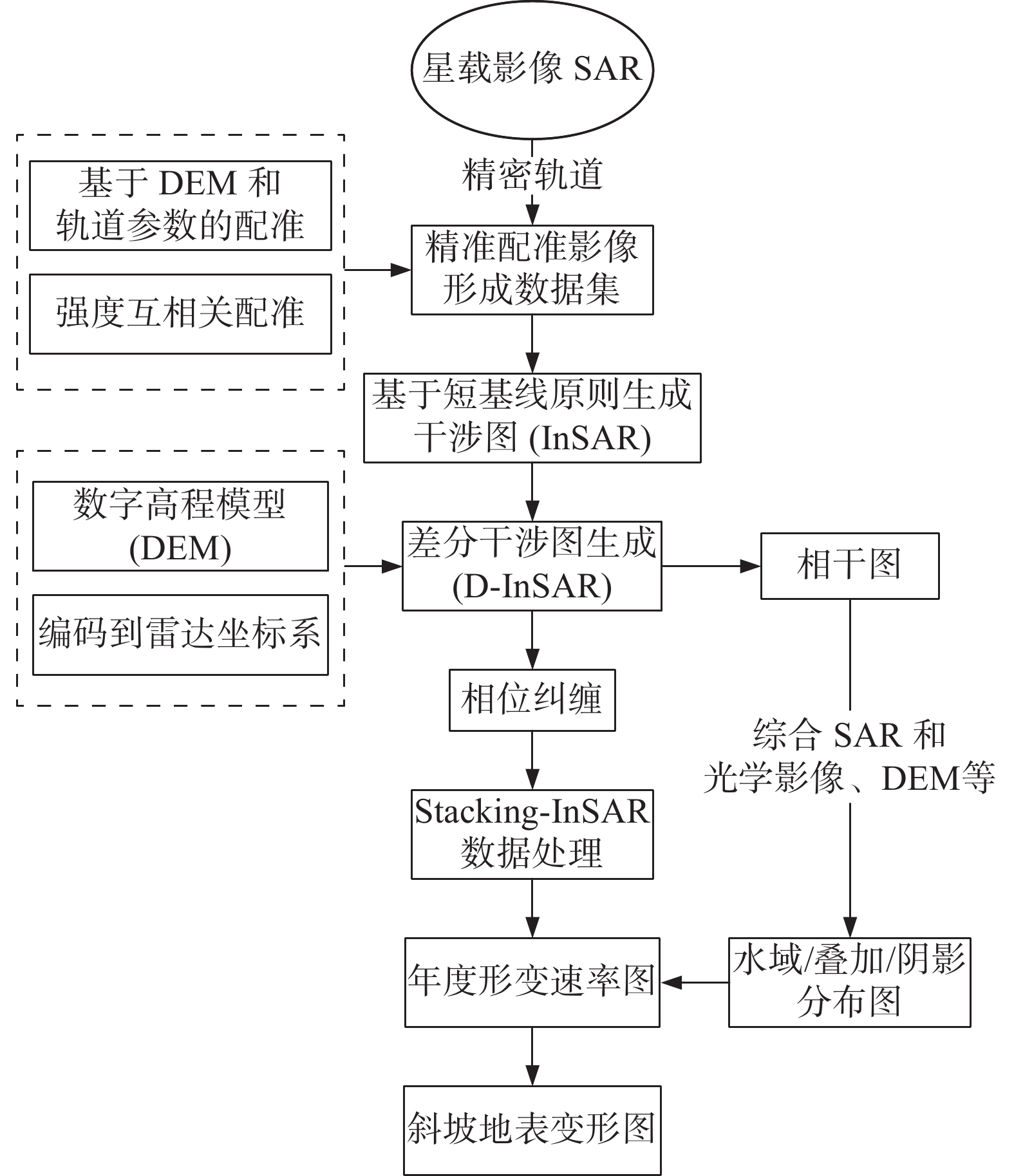
Stacking技术通过组合多个干涉图解决常规InSAR面临的干涉失相干和大气延迟的问题,以实现区域高精度测量[13]。Stacking技术通过生成的多景差分干涉纠缠图估算线性相位速率,实际是基于最小二乘法对N组观测值线性回归的过程,估算公式为:
$$ P{h}_-rate=\sum _{i=1}^{N}\Delta {t}_{i}{\varphi }_{i}∕\sum _{i=1}^{N}\Delta {t}_{i}^{2} $$ 式中:
$ P{h}_{-}rat\mathrm{e} $ ——线性相位速率;$ \Delta {t}_{i} $ ——干涉图的时间基线;${\varphi }_{i}$ ——纠缠的差分干涉相位。Stacking技术具体流程如图1。
(1)选取主影像,对于多时相InSAR数据,选取某一景SAR影像作为主影像,其他影像配准到主影像雷达坐标系下。
(2)在SLC影像中添加精密轨道数据辅助配准。
(3)选取干涉像对,以一定时间间隔作为阈值,生成时间、空间基线分布图,时间间隔小于阈值的影像按时间先后进行两两差分干涉处理。
(4)将DEM与主影像配准,通过计算生成DEM坐标系与影像坐标系的查找表,利用多项式拟合算法,将DEM转换至主影像坐标系下。
(5)计算干涉相位和相干系数,对已配准的影像进行前置滤波,逐像元共轭相乘计算生成干涉图,依据相干系数公式,选择窗体大小,逐像元计算生成相干系数图。
(6)差分干涉计算,依据空间基线参数和地球椭球体参数,计算平地相位,利用配准后DEM计算地形相位,从干涉相位中去除平地相位和地形相位,逐像元计算差分干涉图,并对差分干涉图进行滤波降噪,逐像元计算生成相干系数图,对滤波后的的差分干涉图进行相位解缠。
(7)识别去除差分干涉图中的趋势性条纹。
(8)大气延迟相位校正,选择通用型卫星雷达改正数据(GACOS)校正对流层延迟。
(9)相位叠加处理(Stacking),选取较为理想的相位解缠图,解缠结果组合基于加权叠加估算线性形变速率处理。
(10)地理编码,利用DEM坐标系与影像坐标系的转换查找表,将形变速率图转换到地理坐标系下。
(11)剔除无效区域,综合DEM、SAR相干图和强度图、光学影像等数据剔除水域、阴影、叠掩等无效观测信息。
(12)生成地表形变结果,将地表形变结果分别生成shapefile格式的矢量点文件和geotiff格式的栅格文件,并根据地表形变量值分级设色显示。
根据上述Stacking技术原理、估算公式以及数据处理流程,得到研究区部分InSAR处理成果(图2、图3)。
3. 滑坡隐患识别
3.1 光学遥感解译标志
地质灾害隐患解译标志是指能帮助识别地质灾害类型、范围、性质、变形特征等各类要素的影像特征。研究区滑坡主要分为两大类,分别为潜在滑坡隐患点和古(老)滑坡复活隐患点。
3.1.1 潜在滑坡遥感解译标志
研究区潜在滑坡体地形破碎,起伏不平,斜坡表面有不均匀陷落的斜坡平台;滑坡后缘及两侧可见裂缝;滑坡地表湿地泉水发育,呈斑点或点状深色调;滑坡体上无植被分布或植被与周围有显著区别;滑坡各部分要素在影像上清晰可见(图4)。
3.1.2 古(老)滑坡遥感解译标志
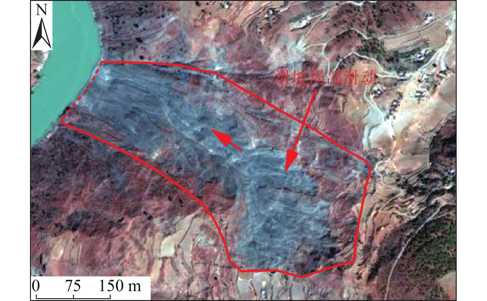
研究区古(老)滑坡体一般具有较高的滑坡后壁,滑坡体上植被较发育;滑坡体一般规模较大;滑坡体两侧冲沟较发育,多出现双沟同源;滑坡平台上通常为耕地和居民点(图5)。
影像上白色、灰白色,崩塌壁呈不规则状,堆积物结构粗糙。崩塌常发生在上部为中厚层状岩体下部为较软岩体内,坡体坡角大于45°且高差较大,或坡体成孤立山嘴,或凹形陡坡地段,尤其是深切割的峡谷区,各江河的陡峻边岸。
3.2 光学遥感识别
研究区范围较大,北面金沙江、澜沧江、怒江三江并流,山高坡陡,河谷深切,植被覆盖率中等,为高山峡谷区域,属于地质灾害高易发区,灾害体一般规模较大,要素特征清晰;南面地形高差相对较小,植被覆盖率极高,为中、低山区域,属于地质灾害中、低易发区,灾害体一般规模较小,要素特征不明显。可根据南北区不同的滑坡发育特征进行潜在滑坡或老滑坡隐患识别。
3.2.1 北面高山峡谷区识别
高山峡谷区岸坡高陡,大规模的古(老)滑坡堆积体坡度相对较缓,地形上与两侧正常斜坡差异明显;高山峡谷区岩质滑坡较多,其中顺向中缓倾斜坡容易发生顺层岩质滑坡在光学影像上有平整的滑面;岩质滑坡规模较大,多为大型以上,后壁通常高陡,两侧边界和后壁基岩出露;古(老)滑坡平台上通常为耕地和居民点;滑坡体上通常有冲沟发育;滑坡两侧的自然沟切割较深,多出现双沟同源;滑坡平台宽大且夷平。
3.2.2 南面中、低山区识别
中、低山区河谷相对宽阔,地区植被覆盖率极高,滑坡隐患点一般以中小型为主,大型以上滑坡相对较少;低山区土质滑坡相对较多,平面形态以半圆形、舌形为主;滑坡后缘有明显的下错台坎或拉裂缝;南面植被覆盖极好,因此潜在滑坡在色调上与周围差异明显;南面以土质滑坡为主,斜坡表部通常为第四系松散堆积层沿基覆界面发生滑动,斜坡中下部的人工切坡为主要诱发因素之一,可通过人工开挖边坡等要素进行识别[15]。
3.3 InSAR识别标志
依据Sentinel-1A和ALOS-2两种数据的InSAR处理成果,对研究区潜在滑坡或老滑坡的解译识别主要采用目视解译和人工交互式解译相结合的方式从InSAR干涉形变图的图斑颜色、分布密度等方面对多期次InSAR监测成果综合识别解译。
3.3.1 典型潜在滑坡识别标志
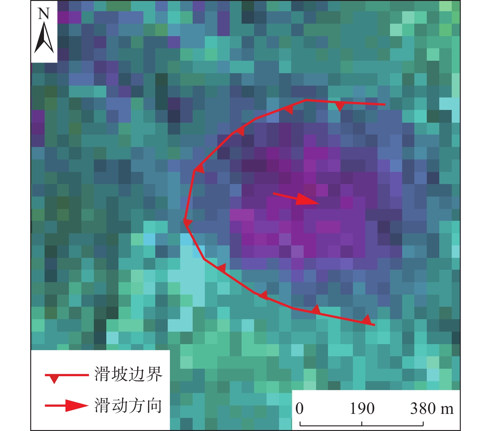
研究区潜在滑坡的InSAR形变干涉图主要存在以下两种典型标志。当潜在滑坡形变量较大时,InSAR形变干涉图多呈现煎蛋状环形形变区,环形InSAR形变区由外向内形变量逐渐增大,InSAR形变区图斑颜色逐渐由环形外圈向中心过渡(图6);当潜在滑坡形变量较小时,InSAR形变干涉图上形变数据异常导致图斑颜色变化较为单一,与周围区域差异明显(图7)。潜在滑坡InSAR形变区范围一般即为潜在滑坡边界,因此潜在滑坡InSAR识别区平面形态多呈矩形、舌型、半圆形等。
![]() 图 6 LCCY-003滑坡(ALOS-2,201801—201808)Figure 6. LCCY-003 landslide (ALOS-2, 201801—201808)
图 6 LCCY-003滑坡(ALOS-2,201801—201808)Figure 6. LCCY-003 landslide (ALOS-2, 201801—201808)![]() 图 7 LCFQ-005滑坡(Sentinel-1A,201803—201901)Figure 7. LCFQ-005 landslide (Sentinel-1A, 201803—201901)
图 7 LCFQ-005滑坡(Sentinel-1A,201803—201901)Figure 7. LCFQ-005 landslide (Sentinel-1A, 201803—201901)3.3.2 典型古(老)滑坡识别标志
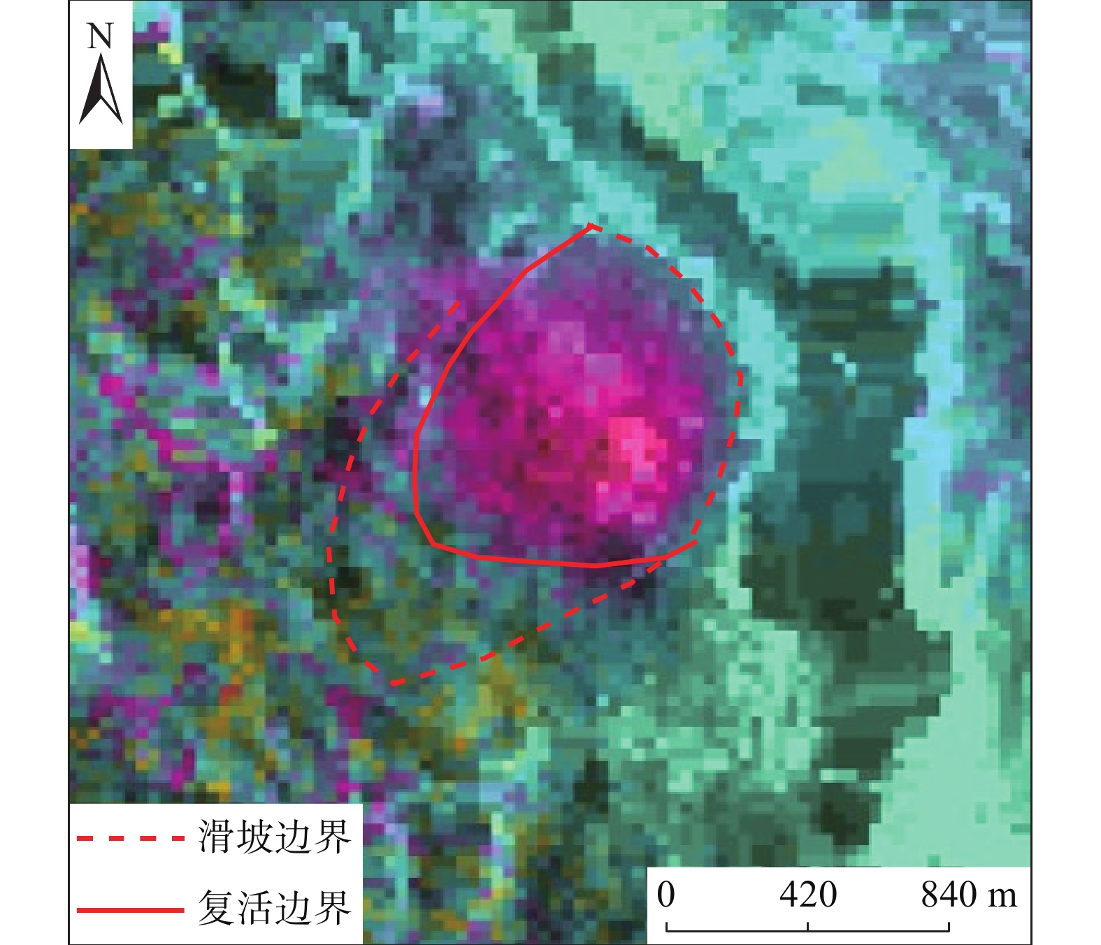
古滑坡体的局部复活一般形变量相对较小,InSAR形变干涉图上形变数据异常导致图斑颜色变化较为单一,与周边区域颜色差异明显。局部复活形变区的面积范围一般有限,图斑颜色异常的区域并未覆盖整个古滑坡堆积体(图8);当古滑坡体整体复活时,由于滑坡规模较大,一般而言斜坡表部形变量也相对较大,InSAR形变干涉图上形变数据异常导致图斑颜色变化较为丰富。通常整体复活形变面积范围较大,图斑颜色异常的区域能够覆盖大部分(乃至整个)的古滑坡堆积体,环形中心图斑颜色差异最为显著的区域则多为古滑坡体变形最为强烈的区域(图9)。
![]() 图 8 LSLS-009滑坡(Sentinel-1A,201702—201905)Figure 8. LSLS-009 landslide (Sentinel-1A, 201702—201905)
图 8 LSLS-009滑坡(Sentinel-1A,201702—201905)Figure 8. LSLS-009 landslide (Sentinel-1A, 201702—201905)![]() 图 9 LCGM-008滑坡(ALOS-2,201808—201908)Figure 9. LCGM-008 Landslide (ALOS-2, 201808—201908)
图 9 LCGM-008滑坡(ALOS-2,201808—201908)Figure 9. LCGM-008 Landslide (ALOS-2, 201808—201908)3.3.3 “无效变形区”InSAR特征
(1)地表沉降导致“无效变形区”
研究区内部分区域属于河谷地貌,地形平缓,坡度处于10°以内,根据潜在滑坡或老滑坡的形成条件,该区域不具备形成潜在滑坡或老滑坡的临空条件,InSAR 形变多由地表沉降、人类工程活动等原因导致,且形变量相对偏小,切关系,结合光学影像分析,该区域属于“无效形变区”(图10)。
![]() 图 10 地表沉降或土地整理导致的“无效变形区”Figure 10. "Invalid deformation zone" caused by surface subsidence or land consolidation
图 10 地表沉降或土地整理导致的“无效变形区”Figure 10. "Invalid deformation zone" caused by surface subsidence or land consolidation(2)跨越斜坡单元导致“无效变形区”
研究区内部分区域属于高山峡谷地貌,地势陡峭,然而InSAR形变区由多个斜坡单元构成,连续跨越多条冲沟、山脊连片分布,斜坡坡向各异,该区域不具备构成单一潜在滑坡或老滑坡的条件,整体大面积InSAR形变也多由植被生长差异、大气延迟干扰等原因导致,结合光学影像分析,该区域属于“无效形变区”(图11)。
![]() 图 11 跨越斜坡单元导致的“无效变形区”Figure 11. "Invalid Deformation Zone" Caused by Crossing Slope Unit
图 11 跨越斜坡单元导致的“无效变形区”Figure 11. "Invalid Deformation Zone" Caused by Crossing Slope Unit(3)数据误差导致“无效变形区”
研究区内部分区域分布的环形疑似形变区以及条带状疑似形变区均未见明显形变特征,不属于潜在滑坡或老滑坡范畴,InSAR形变干涉图异常多由数据处理误差等原因导致,结合光学影像分析,该区域属于“无效形变区”(图12)。
3.4 光学遥感影像与InSAR处理结果的综合分析
为了分析与验证InSAR处理结果的可靠性,选取2处已验证的滑坡点的InSAR处理结果与光学影像进行对比分析。
3.4.1 古(老)滑坡对比分析
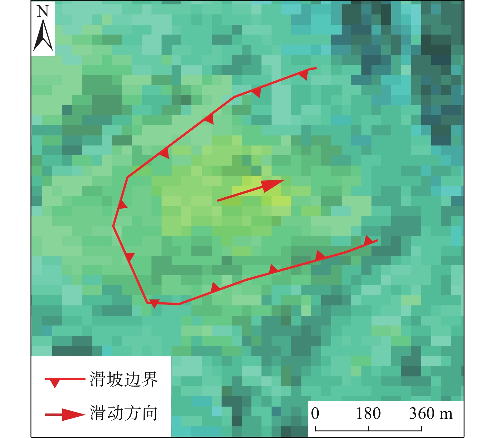
从光学影像上看,LCGM-005滑坡区近似舌形地貌,滑坡体边界明显,滑坡区地貌类型属于构造剥蚀中起伏低中山地貌;滑坡距断裂约 765m;滑坡左侧以冲沟为界,右侧以地形转折处为界,前缘以地冲沟为界;滑坡平面形态呈不规则形,前缘剪出口位于一冲沟处,滑坡整体长1486 m,宽348 m,面积52×104 m2,冠趾相对高差510 m,坡向60 °。滑坡位于斜坡上部,剖面呈凹形,平均坡度23 °,见图13(a)。通过光学影像,依据平面和剖面的地形地貌,可以初步判定该处存在滑坡的可能。
![]() 图 13 LCGM-005滑坡(Sentinel-1A,201902—201907)Figure 13. LCGM-005Landslide (Sentinel-1A, 201902—201907)
图 13 LCGM-005滑坡(Sentinel-1A,201902—201907)Figure 13. LCGM-005Landslide (Sentinel-1A, 201902—201907)LCGM-005滑坡点的InSAR处理结果显示:该区域图斑颜色异常的区域能够覆盖大部分滑坡堆积体,且环形中心图斑颜色差异最为显著,符合古老滑坡体局部乃至整体复活的InSAR干涉图形变特征,见图13(b)。因此,可对该滑坡点的存在情况做出进一步确认。
3.4.2 潜在滑坡对比分析
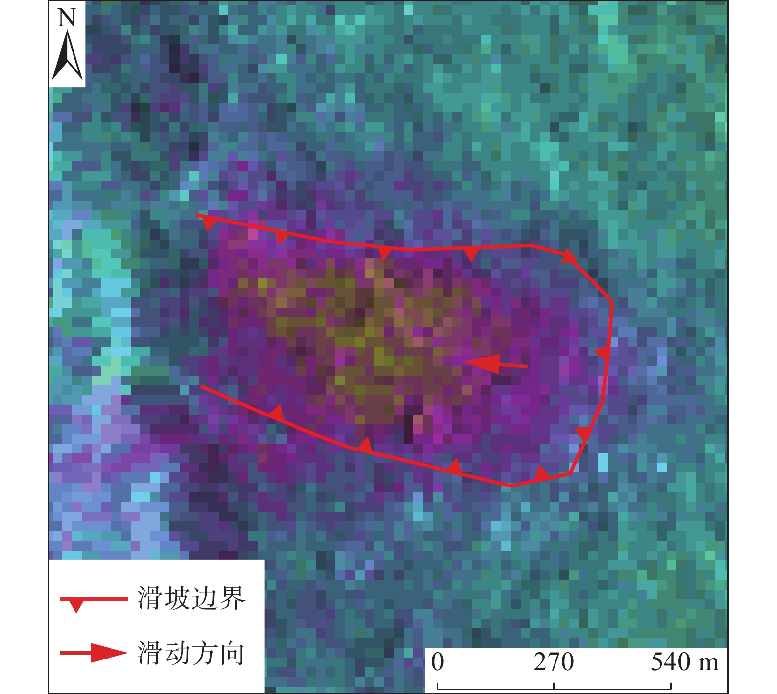
从光学影像上看,LCFQ-010滑坡平面形态近似矩形,左侧及前缘冲沟发育,右侧以地形转折处为界,后缘以地势陡缓交界处为界;滑坡整体长590 m,宽420 m,面积24×104 m2,冠趾相对高差420 m,坡向280 °,平均坡度40 °,剖面呈凹形,见图14(a)。综上所述,通过光学影像,依据平面和剖面的地形地貌,可以初步判定该处存在滑坡的可能。
![]() 图 14 LCFQ-010滑坡(ALOS-2,201801—201808)Figure 14. LCFQ-010 Landslide (ALOS-2, 201801—201808)
图 14 LCFQ-010滑坡(ALOS-2,201801—201808)Figure 14. LCFQ-010 Landslide (ALOS-2, 201801—201808)LCFQ-010滑坡点的InSAR处理结果显示:该区域图斑颜色异常的区域形态规则且颜色单一,但与周围区域差异明显并分布于滑坡区右部,符合形变量较小的潜在滑坡的InSAR干涉图形变特征,见图14(b)。因此,也可对该潜在滑坡点的存在情况做出进一步确认。
3.5 潜在滑坡与老滑坡隐患综合识别
不同的遥感技术各有其优缺点,采用多种遥感技术方法开展潜在滑坡或老滑坡识别可以充分发挥不同方法的优点,互为补充。根据上文建立的不同解译标志,总结出如下适用于研究区的滑坡综合识别方法。
(1)根据不同地形地貌条件,对研究区不同区域分别进行光学遥感识别,并将有光学变形特征的隐患点和无光学变形特征的隐患点区分开来。
(2)将InSAR处理的结果与光学遥感识别结果进行综合分析,区别潜在滑坡、老滑坡和无效变形区的影像特征。
(3)对于既有光学变形特征,同时又具有InSAR地表形变特征的隐患点可直接确定,野外查证只需要进一步复核灾害的边界和不同部位的变形特征。
(4)对于具有InSAR地表形变但无光学变形特征的点,进一步划分为两种情况:
一是光学数据判识为古(老)滑坡,但在光学影像上无法识别出变形,而InSAR地表形变明显,这一类隐患点极有可能是处于变形的初期,变形量小,通过光学遥感无法识别,但可以通过InSAR对微变形的观测进行识别。在室内遥感综合识别的基础上,通过野外验证进一步确定是否存在变形。
二是光学数据判识为正常斜坡,但InSAR地表形变明显,这种情况需要结合孕灾地质背景条件进行综合判识。如InSAR地表形变区无形成地质灾害的孕灾环境条件,且变形区位于平坦的阶地、堆积扇、近水平的厚度岩质斜坡、完整平缓的岩浆岩斜坡,此时可以排除该地表形变是由斜坡地质灾害引起的。如InSAR地表形变区具有形成地质灾害的孕灾条件,且变形区位于高陡的第四系堆积体的前缘、高陡且破碎的基岩斜坡、后部或两侧边缘有断层通过,这一类隐患点则需要进一步通过野外验证确认。
4. 地质灾害隐患野外调查
根据监测对象的不同,野外调查可分为两类。第一,不考虑地质灾害要素条件,针对斜坡变形特征与InSAR监测结果吻合程度进行复核,包括形变的有无,形变的程度等;第二,考虑地质灾害要素条件,除上述内容外,还包括斜坡临空条件、物质组成及威胁对象等孕灾地质环境条件,后者是形成地质灾害的必要条件,直接影响滑坡与潜在滑坡识别的有效性。考虑到滑坡与潜在滑坡InSAR监测识别的准确率和有效性,野外调查内容应包括“变形特征”和“孕灾地质环境条件”两个方面。其中“变形特征”是野外调查内容的核心,一般来说,斜坡如果未见明显变形特征,可不进行孕灾地质环境条件调查工作。同时,只具有“变形特征”却不具备“孕灾地质环境条件”的斜坡,对于潜在滑坡早期识别来说,没有实际意义。变形特征主要表现在以下几个方面,斜坡表部裂缝的类型、数量、规模性质等;斜坡表部固定建筑物如房屋墙面、院坝及地基开裂破坏情况;斜坡表部线性工程如道路、水渠拉裂变形情况;斜坡下坐程度、表部溜滑或局部滑动变形情况等;斜坡表部植被破坏情况;斜坡已有工程如挡土墙、抗滑桩、防护网等的运行及破坏情况[14]。孕灾地质环境条件主要是指形成滑坡的凌空条件、物质组成及激发因素。临空条件包括斜坡高度、坡度、走向、平面形态等;物质组成是滑坡形成的载体,包括斜坡出露的地层岩性、产状、斜坡结构等;激发因素主要指周边人类工程、经济活动,包括修建房屋、公路、土地整理等[15]。
本次研究,共计调查验证潜在滑坡或老滑坡隐患点352处,其中,成功验证284,失败68处,总体识别成功率为80.6%。
5. 结论
(1)基于本文方法的滑坡识别更适用于中型及以上滑坡的识别。文中列举的滑坡识别成功实例均为中型及以上滑坡,无论是在光学影像上还是InSAR结果中都有良好的体现,这是由于部分小型滑坡规模过小,在图上只有像素点般大小,难以直观体现。
(2)高山峡谷地区地势复杂,斜坡单元密布,最易导致在InSAR图像上呈现无效变形区,该区域的滑坡识别需要以光学解译为主。
(3)单独基于光学遥感或者InSAR技术的滑坡识别方法较为片面,部分地区植被覆盖差异高,导致失相干,人类活动区域的部分变形也不是滑坡导致的,潜在滑坡依靠光学影像更是难以判别,为了避免误判,需两者结合,互为补充。
(4)基于本文方法的滑坡识别充分利用了遥感技术进行地质灾害调查,弥补了地面调查的不足,但考虑到误判因素,需要进行部分野外调查验证准确率。
-
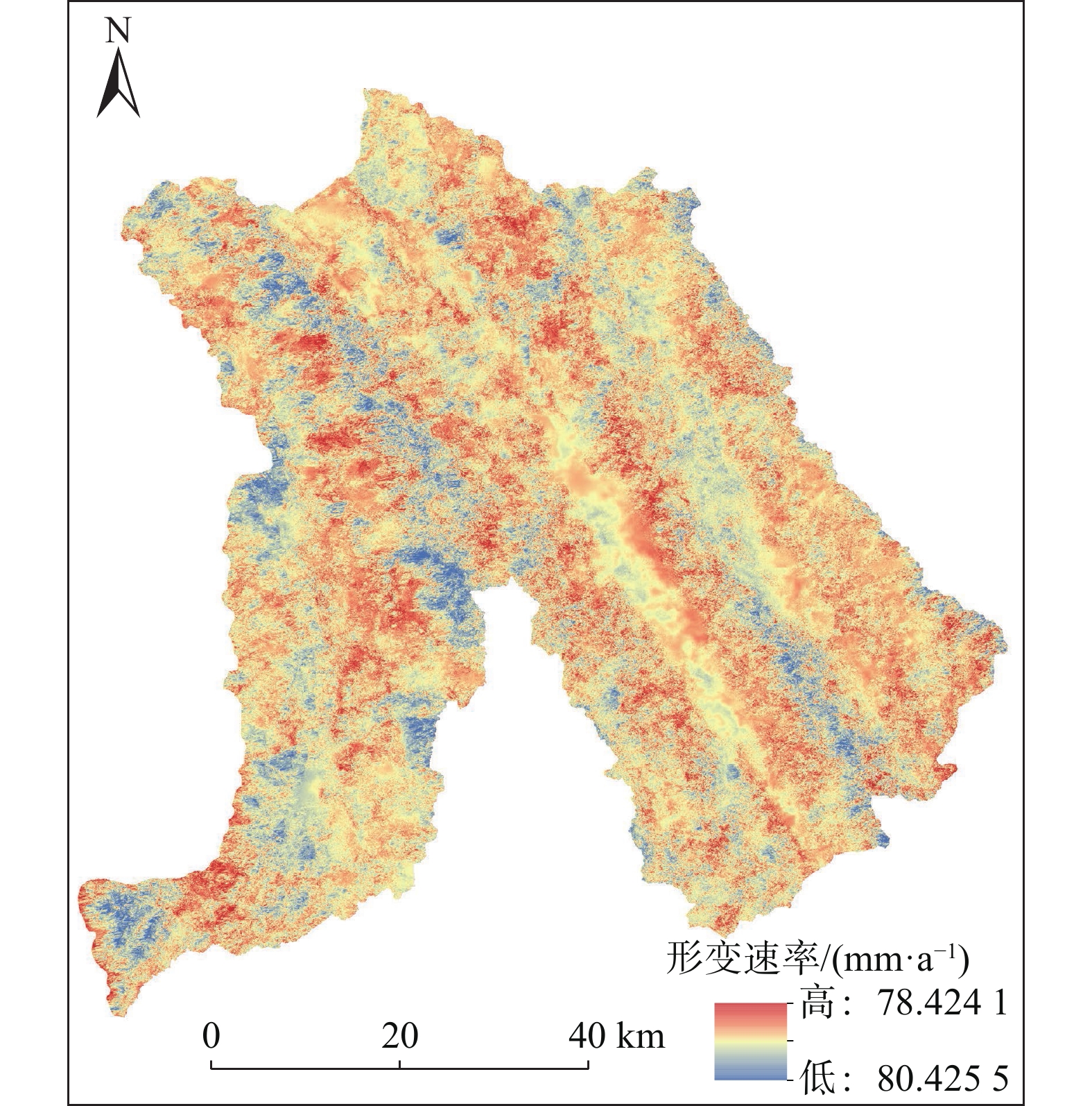
![]()
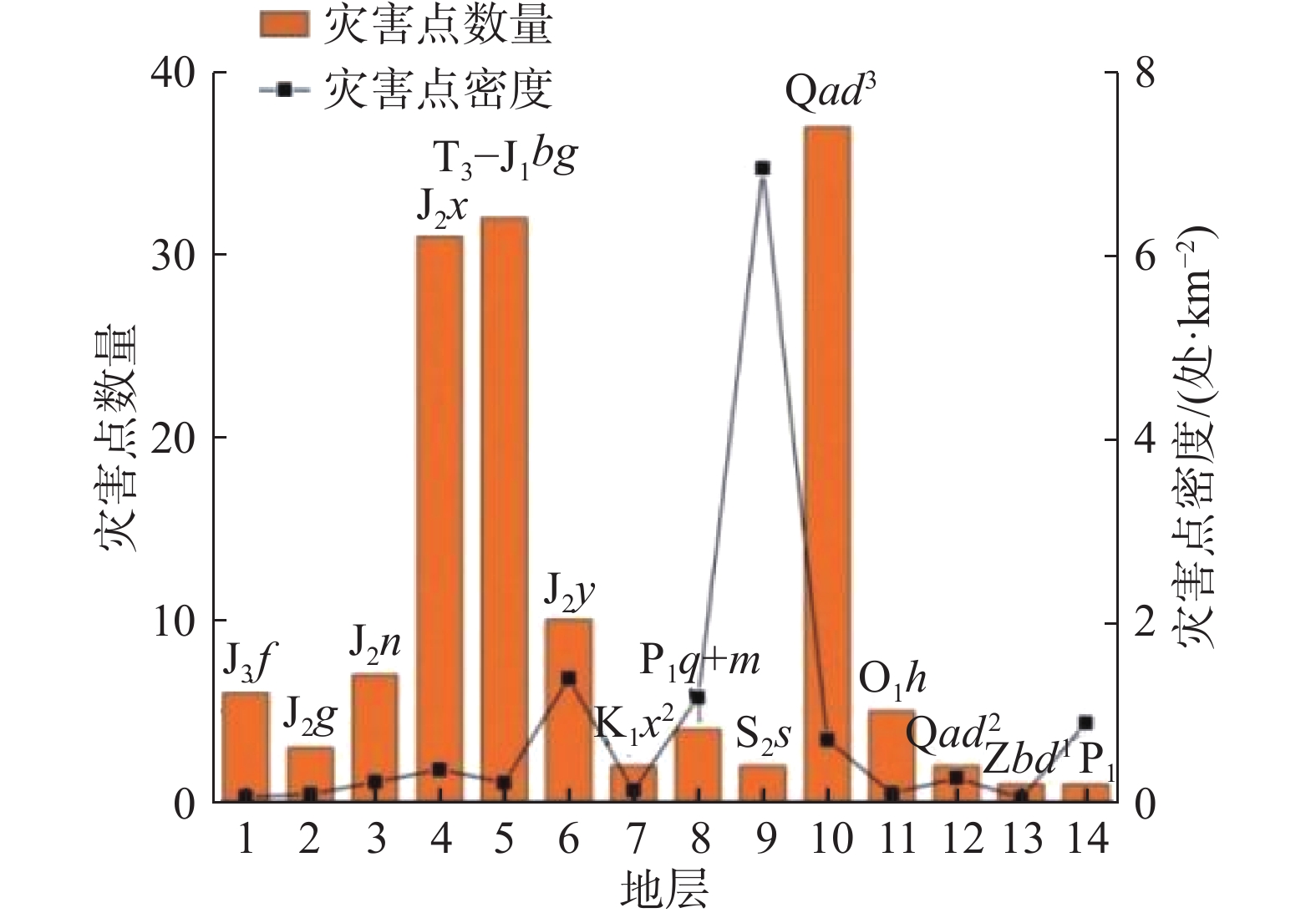
图 3 地层与地灾分布统计关系
Figure 3. Statistical relationship between strata and geological disaster distribution
![]()
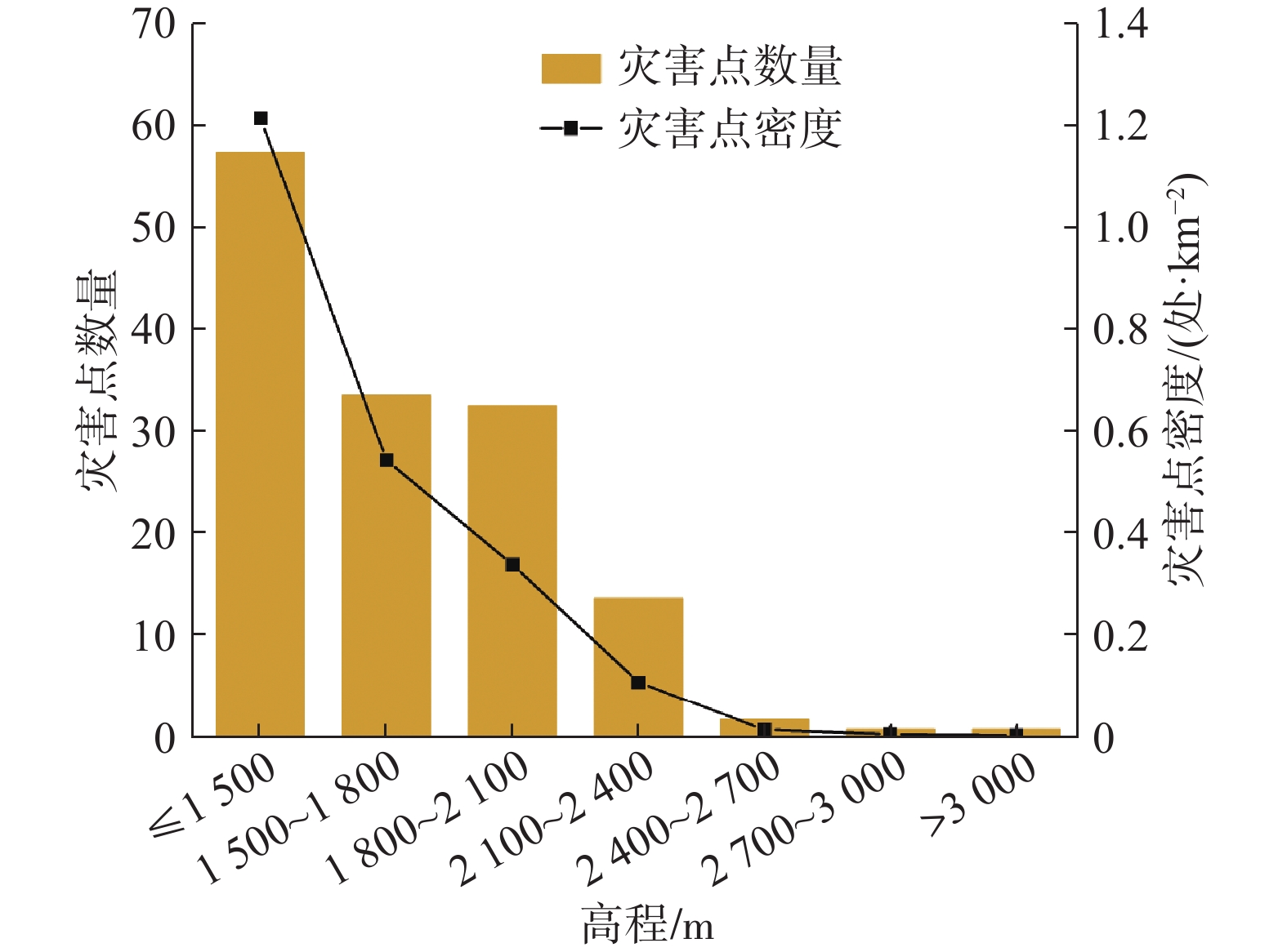
图 4 高程与地灾分布关系
Figure 4. Relationship between elevation and geological disaster distribution
![]()
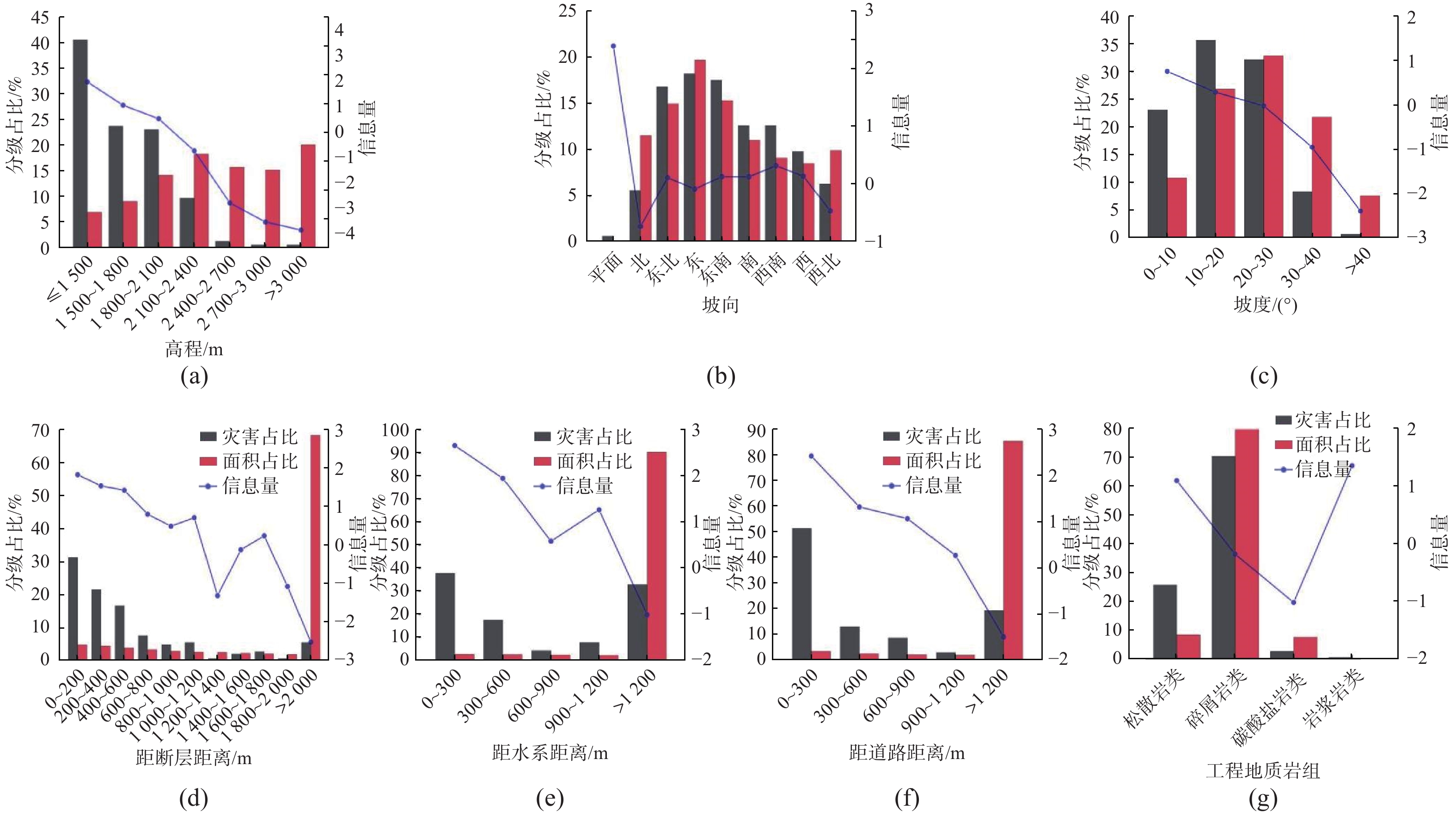
图 6 各因子灾害占比、面积占比、信息量相关性统计
Figure 6. Correlation statistics of disaster proportion, area proportion and information volume of each factor
表 1 则木河断裂带(普格段)地质灾害规模统计表
Table 1 Statistical table of geological disaster scale of Zemuhe fault zone (Puge section)
规模 特大型/处 大型/处 中型/处 小型/处 合计/处 滑坡 0 6 19 80 105 泥石流 0 0 20 18 38 合计 0 6 39 98 143  下载: 导出CSV
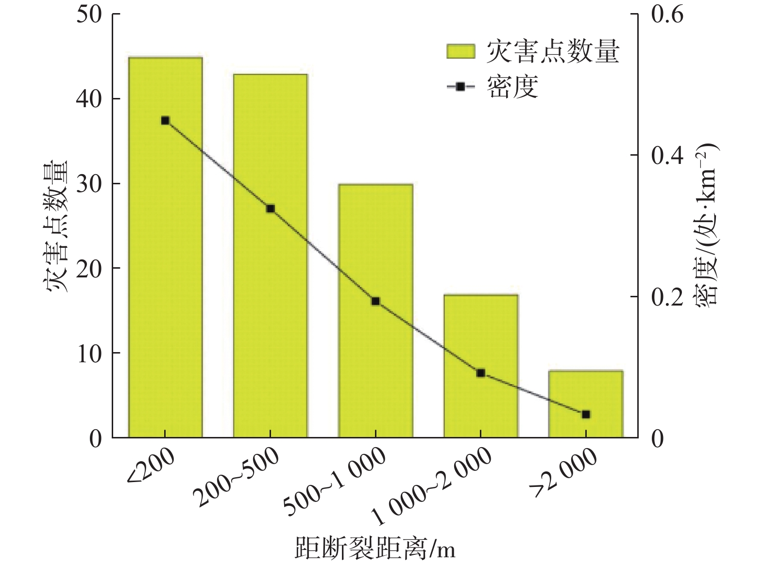
表 2 灾害点分布与距断层距离的关系
Table 2 Relationship between distribution of disaster points and fault distance
距断裂距离/m 灾害点数量/处 面积/km2 密度/(处·km−2) <200 45 83.71788828 0.53751953 200~500 43 110.7142871 0.388387092 500~1000 30 129.3603065 0.231910397 1000~2 000 17 153.1572232 0.11099705 >2 000 8 194.6502949 0.041099347
下载: 导出CSV
表 3 灾害点分布与岩类的关系
Table 3 Relationship between distribution of disaster points and rocks
岩类 灾害点数量/处 面积/km2 密度/(处·km−2) 松散岩土类 37 57.25807612 0.646197052 碎屑岩类 101 561.6624813 0.179823298 碳酸盐岩 4 51.48866247 0.077687005 岩浆岩类 1 1.190780142 0.839785587
下载: 导出CSV
表 4 灾害点分布与高程的关系
Table 4 Relationship between disaster point distribution and elevation
高程/m 灾害点数量/处 面积/km2 密度/(处·km−2) ≤1500 58 47.29627874 1.226312123 1500~1800 34 61.81273055 0.550048505 1800~2100 33 95.51799726 0.345484631 2100~2400 14 123.1613209 0.113672051 2400~2700 2 106.0693742 0.018855584 2700~3000 1 102.444593 0.009761374 >3000 1 135.2977053 0.007391108
下载: 导出CSV
表 5 灾害点分布与坡度的关系
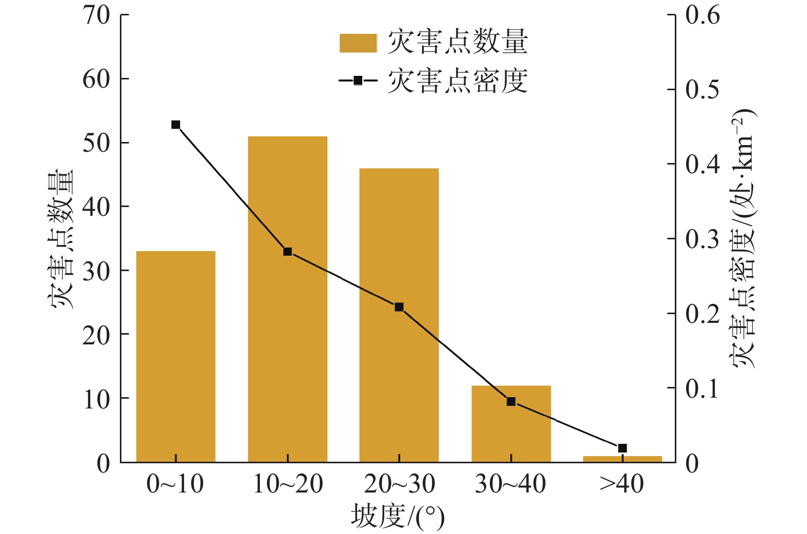
Table 5 Relationship between disaster point distribution and slope
坡度/(°) 灾害点数量/处 面积/km2 密度/(处·km−2) 0~10 33 72.82142422 0.453163342 10~20 51 180.4059596 0.282695761 20~30 46 220.8611978 0.208275607 30~40 12 146.3258923 0.082008726 >40 1 51.18552612 0.019536773
下载: 导出CSV
表 6 评价因子分级信息量值
Table 6 Evaluation factor classification information value
评价因子 分级 Ni Si 信息量 高程/m ≤1500 58 166506 1.750829687 1500~1800 34 217611 0.94906948 1800~2100 33 336270 0.484011174 2100~2400 14 433588 −0.627619424 2400~2700 2 373416 −2.424127878 2700~3000 1 360655 −3.082503802 >3000 1 476314 −3.36065928 坡度/(°) 0~10 33 255445 0.755315656 10~20 51 632833 0.283434285 20~30 46 774743 −0.022074748 30~40 12 513286 −0.954111328 >40 1 179550 −2.388638504 坡向 平地 1 1517 2.385080516 北 8 271199 −0.72159611 东北 24 351885 0.116564629 东 26 463075 −0.077977273 东南 25 360163 0.134134335 南 18 259672 0.132767678 西南 18 214302 0.324800739 西 14 200257 0.141271005 西北 9 233787 −0.455370651 工程地质岩组 松散岩类 37 210750 1.108369157 碎屑岩类 101 2067259 −0.170734496 碳酸盐岩类 4 189510 −1.010023591 岩浆岩类 1 4393 1.368111476 距断层距离/m 0~200 45 294975 1.86212416 200~400 31 272326 1.569339604 400~600 24 236142 1.455972789 600~800 11 202457 0.829720032 800~1000 7 176491 0.514992543 1000~1200 8 161212 0.73907355 1200~1400 1 154822 −1.299923793 1400~1600 3 139739 −0.098811831 1600~1800 4 129360 0.266047423 1800~2000 1 121499 −1.057553755 >2000 8 4145167 −2.507904537 距水系距离/m 0~300 54 190197 2.660820212 300~600 25 179240 1.950046678 600~900 6 168052 0.587382557 900~1200 11 156140 1.267038775 >1200 47 6512889 −1.011494271 距道路距离/m 0~300 74 594601 2.421824195 300~600 20 475861 1.336256172 600~900 14 427658 1.086383213 900~1200 6 401098 0.303203376 >1200 29 11046163 −1.436892883
下载: 导出CSV
表 7 评价因子权重
Table 7 Evaluation factor weight
评价因子 CFmax CFmin 权重 高程 0.826 −0.965 1.792 坡度 0.530 −0.908 1.438 工程地质岩组 0.745 −0.636 1.381 距断层距离 0.845 −0.919 1.763 距水系距离 0.930 −0.636 1.566 距道路距离 0.911 −0.762 1.674 坡向 0.908 −0.514 1.422
下载: 导出CSV
表 8 研究区地质灾害易发分区统计表
Table 8 Statistical table of geological hazard prone zones in the study area
易发性分区 面积/km2 面积占比/% 灾害点/处 灾害占比/% 每百平方公里灾害点密度/处 灾害占比与面积占比比值 低易发区 285.34 42.49 3 2.10 1.05 0.05 中易发区 215.73 32.12 22 15.38 10.20 0.48 高易发区 123.78 18.43 51 35.66 41.20 1.94 极高易发区 46.75 6.96 67 46.85 143.31 6.73 合计 671.60 100.00 143 100.00 − −
下载: 导出CSV
-
[1] 则木河活断裂填图组. 则木河活动断裂带1∶5万地质填图及综合研究[J]. 四川地震,2000(增刊 1):1 − 4. [Working group for geologic mapping on Zemuhe fault. Geologic mapping and comprehensive analysis on the active faults of Zemuhe[J]. Earthquake Research in Sichuan,2000(Sup 1):1 − 4. (in Chinese with English abstract) Working group for geologic mapping on Zemuhe fault. Geologic mapping and comprehensive analysis on the active faults of zemuhe[J]. Earthquake Research in Sichuan, 2000(Sup 1): 1-4. (in Chinese with English abstract)
[2] REN J W, PING L. Earthquake-caused landforms and paleoseismic study on the northern segment of the Zemuhe fault[J]. Seismology & Geology, 1989.
[3] REN Z K, LIN A M. Deformation characteristics of co-seismic surface ruptures produced by the 1850 M 7.5 Xichang earthquake on the eastern margin of the Tibetan Plateau[J]. Journal of Asian Earth Sciences,2010,38(1/2):1 − 13.
[4] 任治坤, 田勤俭, 张军龙. 后差分GPS测量则木河断裂地震微地貌特征[J]. 地震,2007,27(3):97 − 104. [REN Zhikun, TIAN Qinjian, ZHANG Junlong. Micro geomorphology of Zemuhe Fault surveyed by virtue deferential GPS[J]. Earthquake,2007,27(3):97 − 104. (in Chinese with English abstract) DOI: 10.3969/j.issn.1000-3274.2007.03.013 REN Zhikun, TIAN Qinjian, ZHANG Junlong. Micro geomorphology of Zemuhe Fault surveyed by virtue deferential GPS[J]. Earthquake, 2007, 27(3): 97-104. (in Chinese with English abstract) DOI: 10.3969/j.issn.1000-3274.2007.03.013
[5] 杜平山. 则木河断裂带的演化历史及变形机制[J]. 四川地震,2000(增刊 1):65 − 79. [DU Pingshan. Evolution histories and deformation mechanism about active fault of Zemuhe[J]. Earthquake Research in Sichuan,2000(Sup 1):65 − 79. (in Chinese with English abstract) DU Pingshan. Evolution histories and deformation mechanism about active fault of zemuhe[J]. Earthquake Research in Sichuan, 2000(Sup 1): 65 − 79. (in Chinese with English abstract)
[6] 闻学泽. 则木河断裂的第四纪构造活动模式[J]. 地震研究,1983,6(1):41 − 50. [WEN Xueze. Model of active tectonic of the quaternary period of Zemu river fault[J]. Journal of Seismological Research,1983,6(1):41 − 50. (in Chinese with English abstract) WEN Xueze. Model of active tectonic of the quaternary period of zemu river fault[J]. Journal of Seismological Research, 1983, 6(1): 41-50. (in Chinese with English abstract)
[7] 唐荣昌, 黄祖智, 伍先国, 等. 则木河断裂全新世以来的新活动与地震[J]. 中国地震,1986,2(4):84 − 90. [TANG Rongchang, HUANG Zuzhi, WU Xianguo, et al. The new activities and earthquakes of the Zemuhe fault since the Holocene[J]. Earthquake Research in China,1986,2(4):84 − 90. (in Chinese with English abstract) TANG Rongchang, HUANG Zuzhi, WU Xianguo, et al. The new activities and earthquakes of the zemuhe fault since the Holocene[J]. Earthquake Research in China, 1986, 2(4): 84-90. (in Chinese with English abstract)
[8] 冯元保, 杜平山. 1850年西昌地震孕育和发生的地质构造条件[J]. 四川地震,2000(增刊 1):97 − 101. [FENG Yuanbao, DU Pingshan. Geologic tectonic and earthquake preparation conditions about 1850 Xuchuan earthquake[J]. Earthquake Research in Sichuan,2000(Sup 1):97 − 101. (in Chinese with English abstract) FENG Yuanbao, DU Pingshan. Geologic tectonic and earthquake preparation conditions about 1850 xuchuan earthquake[J]. Earthquake Research in Sichuan, 2000(Sup 1): 97-101. (in Chinese with English abstract)
[9] 王虎, 冉勇康, 李彦宝, 等. 则木河断裂上古地震破裂与小型三角状拉分盆地演化[J]. 中国科学(地球科学),2013,43(7):1106 − 1114. [WANG Hu, RAN Yongkang, LI Yanbao, et al. Upper paleoseismic rupture of Zemuhe fault and evolution of small triangular pull apart basin[J]. Scientia Sinica (Terrae),2013,43(7):1106 − 1114. (in Chinese with English abstract) DOI: 10.1360/zd-2013-43-7-1106 WANG Hu, RAN Yongkang, LI Yanbao, et al. Upper paleoseismic rupture of Zemuhe fault and evolution of small triangular pull apart basin [J]. Scientia Sinica (Terrae), 2013, 43(7): 1106-1114. (in Chinese with English abstract) DOI: 10.1360/zd-2013-43-7-1106
[10] 郭乾. 则木河断裂带中段典型古地震滑坡动力学特征研究[D]. 成都: 成都理工大学, 2014 GUO Qian. Research on dynamical characteristics of historical seismic landslide in the middle of Zemuhe fault zone[D]. Chengdu: Chengdu University of Technology, 2014. (in Chinese with English abstract)
[11] 曹文正. 则木河断裂带西昌—普格段重大古滑坡发育特征及成因机理研究[D]. 成都: 成都理工大学, 2015 CAO Wenzheng. Research on development characteristics and genetic mechanism of the seismic landslides from Xichang to Puge along Zemuhe fault zone[D]. Chengdu: Chengdu University of Technology, 2015. (in Chinese with English abstract)
[12] 黄润秋, 向喜琼, 巨能攀. 我国区域地质灾害评价的现状及问题[J]. 地质通报,2004,23(11):1078 − 1082. [HUANG Runqiu, XIANG Xiqiong, JU Nengpan. Assessment of China's regional geohazards: Present situation and problems[J]. Regional Geology of China,2004,23(11):1078 − 1082. (in Chinese with English abstract) DOI: 10.3969/j.issn.1671-2552.2004.11.005 HUANG Runqiu, XIANG Xiqiong, JU Nengpan. Assessment of China's regional geohazards: present situation and problems[J]. Regional Geology of China, 2004, 23(11): 1078-1082. (in Chinese with English abstract) DOI: 10.3969/j.issn.1671-2552.2004.11.005
[13] GUZZETTI F, REICHENBACH P, CARDINALI M, et al. Probabilistic landslide hazard assessment at the basin scale[J]. Geomorphology,2005,72(1/2/3/4):272 − 299.
[14] 倪化勇, 王德伟, 陈绪钰, 等. 四川雅江县城地质灾害发育特征与稳定性评价[J]. 现代地质,2015,29(2):474 − 480. [NI Huayong, WANG Dewei, CHEN Xuyu, et al. Formation characteristics and stability assessment of geological hazards in Yajiang City, Sichuan Province[J]. Geoscience,2015,29(2):474 − 480. (in Chinese with English abstract) DOI: 10.3969/j.issn.1000-8527.2015.02.036 NI Huayong, WANG Dewei, CHEN Xuyu, et al. Formation characteristics and stability assessment of geological hazards in Yajiang City, Sichuan Province[J]. Geoscience, 2015, 29(2): 474-480. (in Chinese with English abstract) DOI: 10.3969/j.issn.1000-8527.2015.02.036
[15] 阮沈勇, 黄润秋. 基于GIS的信息量法模型在地质灾害危险性区划中的应用[J]. 成都理工学院学报,2001,28(1):89 − 92. [RUAN Shenyong, HUANG Runqiu. Application of gis-based information model on assessment of geological hazards risk[J]. Journal of Chengdu University of Technology,2001,28(1):89 − 92. (in Chinese with English abstract) RUAN Shenyong, HUANG Runqiu. Application of gis-based information model on assessment of geological hazards risk[J]. Journal of Chengdu University of Technology, 2001, 28(1): 89-92. (in Chinese with English abstract)
[16] 薛强, 张茂省, 李林. 基于斜坡单元与信息量法结合的宝塔区黄土滑坡易发性评价[J]. 地质通报,2015,34(11):2108 − 2115. [XUE Qiang, ZHANG Maosheng, LI Lin. Loess landslide susceptibility evaluation based on slope unit and information value method in Baota District, Yanan[J]. Geological Bulletin of China,2015,34(11):2108 − 2115. (in Chinese with English abstract) DOI: 10.3969/j.issn.1671-2552.2015.11.017 XUE Qiang, ZHANG Maosheng, LI Lin. Loess landslide susceptibility evaluation based on slope unit and information value method in Baota District, Yan'an[J]. Geological Bulletin of China, 2015, 34(11): 2108-2115. (in Chinese with English abstract) DOI: 10.3969/j.issn.1671-2552.2015.11.017
[17] 陈朝亮, 张文君, 钱静, 等. 基于改进Logistic回归模型在地质灾害评价中的应用[J]. 环境科学与技术,2019,42(4):188 − 193. [CHEN Chaoliang, ZHANG Wenjun, QIAN Jing, et al. Application of improved logistic regression model in geological hazard evaluation[J]. Environmental Science & Technology,2019,42(4):188 − 193. (in Chinese with English abstract) CHEN Chaoliang, ZHANG Wenjun, QIAN Jing, et al. Application of improved logistic regression model in geological hazard evaluation[J]. Environmental Science & Technology, 2019, 42(4): 188-193. (in Chinese with English abstract)
[18] 赵成, 张永军, 赵玉红. 层次分析法在甘肃省地质灾害易发性评价中的应用[J]. 冰川冻土,2009,31(1):182 − 188. [ZHAO Cheng, ZHANG Yongjun, ZHAO Yuhong. Application of the hierarchical analytical methods to evaluating geological hazard tendency in Gansu Province[J]. Journal of Glaciology and Geocryology,2009,31(1):182 − 188. (in Chinese with English abstract) ZHAO Cheng, ZHANG Yongjun, ZHAO Yuhong. Application of the hierarchical analytical methods to evaluating geological hazard tendency in Gansu Province[J]. Journal of Glaciology and Geocryology, 2009, 31(1): 182-188. (in Chinese with English abstract)
[19] 许冲, 戴福初, 姚鑫, 等. 基于GIS与确定性系数分析方法的汶川地震滑坡易发性评价[J]. 工程地质学报,2010,18(1):15 − 26. [XU Chong, DAI Fuchu, YAO Xin, et al. GIS platform and certainty factor analysis method based Wenchuan earthquake-induced landslide susceptibility evaluation[J]. Journal of Engineering Geology,2010,18(1):15 − 26. (in Chinese with English abstract) DOI: 10.3969/j.issn.1004-9665.2010.01.003 XU Chong, DAI Fuchu, YAO Xin, et al. GIS platform and certainty factor analysis method based Wenchuan earthquake-induced landslide susceptibility evaluation[J]. Journal of Engineering Geology, 2010, 18(1): 15-26. (in Chinese with English abstract) DOI: 10.3969/j.issn.1004-9665.2010.01.003
[20] 李益敏, 李驭豪, 赵志芳. 基于确定性系数模型的泸水市泥石流易发性评价[J]. 水土保持研究,2019,26(4):336 − 342. [LI Yimin, LI Yuhao, ZHAO Zhifang. Assessment on susceptibility of debris flow in Lushui based on the certain factor model[J]. Research of Soil and Water Conservation,2019,26(4):336 − 342. (in Chinese with English abstract) LI Yimin, LI Yuhao, ZHAO Zhifang. Assessment on susceptibility of debris flow in Lushui based on the certain factor model[J]. Research of Soil and Water Conservation, 2019, 26(4): 336-342. (in Chinese with English abstract)
[21] SANDRIC I, IONITA C, CHITU Z, et al. Using CUDA to accelerate uncertainty propagation modelling for landslide susceptibility assessment[J]. Environmental Modelling & Software,2019,115:176 − 186.
[22] ADITIAN A, KUBOTA T, SHINOHARA Y. Comparison of GIS-based landslide susceptibility models using frequency ratio, logistic regression, and artificial neural network in a tertiary region of Ambon, Indonesia[J]. Geomorphology,2018,318:101 − 111. DOI: 10.1016/j.geomorph.2018.06.006
[23] 张书豪, 吴光. 随机森林与GIS的泥石流易发性及可靠性[J]. 地球科学,2019,44(9):3115 − 3134. [ZHANG Shuhao, WU Guang. Debris flow susceptibility and its reliability based on random forest and GIS[J]. Earth Science,2019,44(9):3115 − 3134. (in Chinese with English abstract) ZHANG Shuhao, WU Guang. Debris flow susceptibility and its reliability based on random forest and GIS[J]. Earth Science, 2019, 44(9): 3115-3134. (in Chinese with English abstract)
[24] 黄立鑫, 郝君明, 李旺平, 等. 基于RBF神经网络-信息量耦合模型的滑坡易发性评价: 以甘肃岷县为例[J]. 中国地质灾害与防治学报,2021,32(6):116 − 126. [HUANG Lixin, HAO Junming, LI Wangping, et al. Landslide susceptibility assessment by the coupling method of RBF neural network and information value: A case study in Min Xian, Gansu Province[J]. The Chinese Journal of Geological Hazard and Control,2021,32(6):116 − 126. (in Chinese with English abstract) HUANG Lixin, HAO Junming, LI Wangping, et al. Landslide susceptibility assessment by the coupling method of RBF neural network and information value: a case study in Min Xian, Gansu Province[J]. The Chinese Journal of Geological Hazard and Control, 2021, 32(6): 116-126. (in Chinese with English abstract)
[25] 刘福臻, 王灵, 肖东升. 机器学习模型在滑坡易发性评价中的应用[J]. 中国地质灾害与防治学报,2021,32(6):98 − 106. [LIU Fuzhen, WANG Ling, XIAO Dongsheng. Application of machine learning model in landslide susceptibility evaluation[J]. The Chinese Journal of Geological Hazard and Control,2021,32(6):98 − 106. (in Chinese with English abstract) LIU Fuzhen, WANG Ling, XIAO Dongsheng. Application of machine learning model in landslide susceptibility evaluation[J]. The Chinese Journal of Geological Hazard and Control, 2021, 32(6): 98-106. (in Chinese with English abstract)
[26] 周天伦, 曾超, 范晨, 等. 基于快速聚类-信息量模型的汶川及周边两县滑坡易发性评价[J]. 中国地质灾害与防治学报,2021,32(5):137 − 150. [ZHOU Tianlun, ZENG Chao, FAN Chen, et al. Landslide susceptibility assessment based on K-means cluster information model in Wenchuan and two neighboring counties, China[J]. The Chinese Journal of Geological Hazard and Control,2021,32(5):137 − 150. (in Chinese with English abstract) Tianlun ZHOU, Chao ZENG, Chen FAN, Hongji BI, Enhui GONG, Xiao LIU. Landslide susceptibility assessment based on K-means cluster information model in Wenchuan and two neighboring counties, China[J]. The Chinese Journal of Geological Hazard and Control, 2021, 32(5): 137-150. (in Chinese with English abstract)
[27] 方然可, 刘艳辉, 黄志全. 基于机器学习的区域滑坡危险性评价方法综述[J]. 中国地质灾害与防治学报,2021,32(4):1 − 8. [FANG Ranke, LIU Yanhui, HUANG Zhiquan. A review of the methods of regional landslide hazard assessment based on machine learning[J]. The Chinese Journal of Geological Hazard and Control,2021,32(4):1 − 8. (in Chinese with English abstract) Ranke FANG, Yanhui LIU, Zhiquan HUANG. A review of the methods of regional landslide hazard assessment based on machine learning[J]. The Chinese Journal of Geological Hazard and Control, 2021, 32(4): 1-8. (in Chinese with English abstract)
[28] 郭学飞, 王志一, 焦润成, 等. 基于层次分析法的北京市地质环境质量综合评价[J]. 中国地质灾害与防治学报,2021,32(1):70 − 76. [GUO Xuefei, WANG Zhiyi, JIAO Runcheng, et al. Comprehensive evaluation method of geological environment quality in Beijing based on AHP[J]. The Chinese Journal of Geological Hazard and Control,2021,32(1):70 − 76. (in Chinese with English abstract) GUO Xuefei, WANG Zhiyi, JIAO Runcheng, et al. Comprehensive evaluation method of geological environment quality in Beijing based on AHP[J]. The Chinese Journal of Geological Hazard and Control, 2021, 32(1): 70-76. (in Chinese with English abstract)
[29] 张晓东, 刘湘南, 赵志鹏, 等. 信息量模型、确定性系数模型与逻辑回归模型组合评价地质灾害敏感性的对比研究[J]. 现代地质,2018,32(3):602 − 610. [ZHANG Xiaodong, LIU Xiangnan, ZHAO Zhipeng, et al. Comparative study of geological hazards susceptibility assessment: Constraints from the information value + logistic regression model and the CF + logistic regression model[J]. Geoscience,2018,32(3):602 − 610. (in Chinese with English abstract) ZHANG Xiaodong, LIU Xiangnan, ZHAO Zhipeng, et al. Comparative study of geological hazards susceptibility assessment: constraints from the information value + logistic regression model and the CF + logistic regression model[J]. Geoscience, 2018, 32(3): 602-610. (in Chinese with English abstract)
[30] 田春山, 刘希林, 汪佳. 基于CF和Logistic回归模型的广东省地质灾害易发性评价[J]. 水文地质工程地质,2016,43(6):154 − 161. [TIAN Chunshan, LIU Xilin, WANG Jia. Geohazard susceptibility assessment based on CF model and Logistic Regression models in Guangdong[J]. Hydrogeology & Engineering Geology,2016,43(6):154 − 161. (in Chinese with English abstract) TIAN Chunshan, LIU Xilin, WANG Jia. Geohazard susceptibility assessment based on CF model and Logistic Regression models in Guangdong[J]. Hydrogeology & Engineering Geology, 2016, 43(6): 154-161. (in Chinese with English abstract)
[31] 李远远, 梅红波, 任晓杰, 等. 基于确定性系数和支持向量机的地质灾害易发性评价[J]. 地球信息科学学报,2018,20(12):1699 − 1709. [LI Yuanyuan, MEI Hongbo, REN Xiaojie, et al. Geological disaster susceptibility evaluation based on certainty factor and support vector machine[J]. Journal of Geo-Information Science,2018,20(12):1699 − 1709. (in Chinese with English abstract) DOI: 10.12082/dqxxkx.2018.180349 LI Yuanyuan, MEI Hongbo, REN Xiaojie, et al. Geological disaster susceptibility evaluation based on certainty factor and support vector machine[J]. Journal of Geo-Information Science, 2018, 20(12): 1699-1709. (in Chinese with English abstract) DOI: 10.12082/dqxxkx.2018.180349
[32] 樊芷吟, 苟晓峰, 秦明月, 等. 基于信息量模型与Logistic回归模型耦合的地质灾害易发性评价[J]. 工程地质学报,2018,26(2):340 − 347. [FAN Zhiyin, GOU Xiaofeng, QIN Mingyue, et al. Information and logistic regression models based coupling analysis for susceptibility of geological hazards[J]. Journal of Engineering Geology,2018,26(2):340 − 347. (in Chinese with English abstract) FAN Zhiyin, GOU Xiaofeng, QIN Mingyue, et al. Information and logistic regression models based coupling analysis for susceptibility of geological hazards[J]. Journal of Engineering Geology, 2018, 26(2): 340-347. (in Chinese with English abstract)
[33] 何原荣, 傅文杰. 模糊支持向量机在滑坡危险性评价中的应用[J]. 自然灾害学报,2009,18(5):107 − 112. [HE Yuanrong, FU Wenjie. Application of fuzzy support vector machine to landslide risk assessment[J]. Journal of Natural Disasters,2009,18(5):107 − 112. (in Chinese with English abstract) DOI: 10.3969/j.issn.1004-4574.2009.05.016 HE Yuanrong, FU Wenjie. Application of fuzzy support vector machine to landslide risk assessment[J]. Journal of Natural Disasters, 2009, 18(5): 107-112. (in Chinese with English abstract) DOI: 10.3969/j.issn.1004-4574.2009.05.016
[34] 冯文凯, 黄润秋, 许强. 斜坡震裂变形发育分布规律及危险性分析[J]. 成都理工大学学报(自然科学版),2010,37(6):679 − 684. [FENG Wenkai, HUANG Runqiu, XU Qiang. Analysis of the development, distribution rules and risk of slope shattering deformation[J]. Journal of Chengdu University of Technology (Science & Technology Edition),2010,37(6):679 − 684. (in Chinese with English abstract) FENG Wenkai, HUANG Runqiu, XU Qiang. Analysis of the development, distribution rules and risk of slope shattering deformation[J]. Journal of Chengdu University of Technology (Science & Technology Edition), 2010, 37(6): 679-684. (in Chinese with English abstract)
[35] 殷坤龙, 晏同珍. 汉江河谷旬阳段区域滑坡规律及斜坡不稳定性预测[J]. 地球科学,1987,12(6):631 − 638. [YIN Kunlong, YAN Tongzhen. Distribution regularity of landslides and prediction of slope instability nearby Xunyang, Han River valley[J]. Earth Science,1987,12(6):631 − 638. (in Chinese with English abstract) YIN Kunlong, YAN Tongzhen. Distribution regularity of landslides and prediction of slope instability nearby Xunyang, Han River valley[J]. Earth Science, 1987, 12(6): 631-638. (in Chinese with English abstract)
[36] SHORTLIFFE E H, BUCHANAN B G. A model of inexact reasoning in medicine[J]. Mathematical Biosciences,1975,23(3/4):351 − 379.
[37] HECKERMAN D. Probabilistic interpretations for MYCIN's certainty factors[J]. CoRR,2013,abs/1304.3419:167 − 196.
[38] 刘艳辉, 刘传正, 唐灿, 等. 基于确定性系数模型的地质灾害多因子权重计算方法[J]. 中国地质灾害与防治学报,2015,26(1):92 − 97. [LIU Yanhui, LIU Chuanzheng, TANG Can, et al. CF-based multi-factor overlay method to determine weights of the factors for geo-hazards[J]. The Chinese Journal of Geological Hazard and Control,2015,26(1):92 − 97. (in Chinese with English abstract) LIU Yanhui, LIU Chuanzheng, TANG Can, et al. CF-based multi-factor overlay method to determine weights of the factors for geo-hazards[J]. The Chinese Journal of Geological Hazard and Control, 2015, 26(1): 92-97. (in Chinese with English abstract)
-
期刊类型引用(15)
1. 王勇,邢振涛,李锁,闫勇,司甜. 基于SBAS-InSAR和光学遥感的天津市北部山区潜在滑坡识别研究. 灾害学. 2025(01): 30-35 .  百度学术
百度学术
2. 毛正君,李欢,石硕杰,孙婕文,仲佳鑫,于海泳. 面向对象的无人机遥感影像区域滑坡承灾体信息提取研究. 工程地质学报. 2025(01): 171-185 . 百度学术
3. 冯谕,曾怀恩,涂鹏飞. 遗传算法下的滑坡蠕滑位移预测模型研究. 中国地质灾害与防治学报. 2024(01): 82-91 . 本站查看
4. 杨豹,赵瑞志,王海波,李晓光,吕钊,赵阳,王梦云. 遥感技术对地质灾害早期识别和动态监测——以昌波乡至羊拉乡段为例. 科学技术与工程. 2024(05): 1823-1836 . 百度学术
5. 李恒丽,陈克全. 云南维西县新塘房滑坡形成条件及防治措施探讨. 云南地质. 2024(01): 115-120 . 百度学术
6. 毛正君,于海泳,梁伟,马旭,仲佳鑫,高广胜,石硕杰,田彦山. 基于无人机倾斜摄影测量三维建模的区域黄土滑坡识别及特征分析. 中国地质. 2024(02): 561-576 . 百度学术
7. 薛玉芹,滕秀华,孟大鹏. 遥感测量在采矿塌陷地监测及矿山地质灾害治理方面的应用. 世界有色金属. 2024(03): 157-159 . 百度学术
8. 党杰,杨亮,段方情,范宣梅. 贵州晴隆红寨大型古滑坡复活变形特征及成因分析. 中国地质灾害与防治学报. 2024(04): 25-35 . 本站查看
9. 孙成永. InSAR技术在河南信阳新县地质灾害风险调查中的应用. 城市地质. 2024(03): 383-389 . 百度学术
10. 孙琪皓,刘桂卫,王飞,张璇钰,王衍汇. 铁路地质灾害早期识别与监测预警技术及应用研究. 铁道标准设计. 2024(09): 24-31 . 百度学术
11. 钱雨扬,孔令利,余洲,杨国兴,朋仁锋. 基于InSAR-光学影像的白鹤滩库区地质灾害隐患识别. 人民长江. 2024(S2): 107-112+120 . 百度学术
12. 韩民赛,刘岁海,罗明,蒋韬,孙大振. 滑坡预测预报研究与进展. 地质装备. 2023(01): 22-26+39 . 百度学术
13. 朱伟伟. 遥感技术在地质灾害监测与管理中的应用. 安徽地质. 2023(01): 75-77+90 . 百度学术
14. 黎浩良,杨莹辉,许强,宋家苇,李鹏飞,陈强,姚智博. 高寒山区地质灾害季节分区InSAR早期识别研究——以东构造结地区为例. 工程地质学报. 2023(03): 780-795 . 百度学术
15. 李芳军. 黄土滑坡地质灾害监测预警方法与技术探讨. 冶金管理. 2023(15): 82-84 . 百度学术
其他类型引用(16)


计量
- 文章访问数: 396
- HTML全文浏览量: 298
- PDF下载量: 403
- 被引次数: 31
 邮件订阅
邮件订阅 RSS
RSS