Analysis on deformation characteristics of geological hazards in Ranwu Lake Estuary
-
摘要: 青藏高原持续隆升使得其周缘地带地质灾害频发,复杂的地质背景,造就了帕隆藏布流域链式灾害发育、堵江致灾风险高的特点。近年来,地处帕隆藏布流域的然乌湖口地质灾害变形强烈,本文通过光学遥感与InSAR监测技术,对然乌湖口82道班沟内进行风险物源识别,解译出研究区共存在高位冰崩、崩塌、冰碛物、崩滑体4种风险物源类型,针对各风险物源的遥感解译数据进行特征分析,综合然乌湖流域内的地质背景,阐述风险物源的致灾因素及成灾模式。结合InSAR监测结果,将然乌湖口右岸斜坡体及上部解译风险物源区划分为82道班、迫隆与哑隆三个高风险区,并依据变形监测结果进行形变特征分析。Abstract: The continuous uplift of the Qinghai Tibet Plateau has led to frequent geological disasters in its surrounding areas. The complex geological background has created the characteristics of chain disaster development and high risk of river blocking in the Palongzangbu basin. In recent years, Ranwu Lake estuary, located in the Palongzangbu basin, has experienced severe geological deformation. In this paper, the risk material sources identification in 82 road class at Ranwu Lake are carried out by optical remote sensing and InSAR monitoring technology. It can be found that there are four risk source types in the study area: high-level ice debris, collapse, moraine and avalanche. Characteristics analysis and disaster risk assessment are carried out for each risk source, and based on the geological background of Ranwu Lake, this paper expounds the disaster causing factors and modes of risk material sources. Combined with the InSAR monitoring results. The slope body and its upper interpretation risk material sources areas on the right bank of Ranwu Lake estuary are divided into three high risk areas: 82 road class, Polong and Yalong, and the deformation characteristics are analyzed.
-
2010年8月8日凌晨,舟曲县城北侧三眼峪沟和罗家峪沟同时暴发特大山洪泥石流,城区三分之一被淹,共造成1435人死亡,330人失踪,直接经济损失超过10亿元[1-2],给舟曲县城居民生命财产造成了巨大损失,也给当地生产生活带来严重困难。灾害引起了党中央、国务院、中央军委及全国人民的高度关注,启动国家二级救灾应急响应,同时批复专项资金进行治理。其中,重力式拦挡坝是舟曲泥石流治理中的最主要工程之一。
周龙茂等[3]认为拦挡坝在泥石流治理中发挥着重要作用,但同时拦挡坝也是最易遭受破坏、失去防灾功能的泥石流防治构筑物,因此,在泥石流设计中,为了拦挡坝不被破坏,往往设计得很保守,王念秦等[4]提出这种设计容易造成两个极端现象:保守,造成资金浪费;冒进,防治工程失败。要做到既能保证拦挡坝安全,又能将投资最小化,就要求对泥石流拦挡坝抗冲击力验算方法提出新要求。传统的泥石流冲击力计算经验公式[5]只能通过大量试算表述结果,不能表述过程。而将三维有限元数值分析方法应用到泥石流拦挡坝稳定性验算中[6-7],能将过程和结果同时呈现,即通过分步加载的方法,逐步呈现拦挡坝的位移情况和抗冲击力过程中的破损情况。
关于拦挡坝的数值模拟研究还比较少,本文将考虑损伤的混凝土本构模型与有限元计算方法相结合,对舟曲泥石流混凝土拦挡结构进行力学分析,最终确定了拦挡坝的抗冲击力合理区间,以期为泥石流治理工程的设计提供借鉴。
1. 模型建立及相关参数的设定
杨东旭等[8]、许海亮等[9]、张睿骁等[10]认为冲击力是破坏防治工程构筑物的主要作用力之一,其大小与泥石流流量、流速、容重等有关。泥石流冲击力是泥石流防治工程设计的重要参数,分为流体整体冲击力和个别石块的冲击力两种,在设计中取两种计算结果较高者为设计依据。文章采用《泥石流灾害防治工程设计规范》(DZT 0239—2004)中的经验公式[5]作为数值计算结果的参考和验证。
流体整体冲击力计算公式:
$$f = K\frac{{{\gamma_C}}}{g}v_c^2$$ (1) 式(1)中:f−冲击力/Pa;
K−系数,取2.5;
${\gamma_C} $ −泥石流重度/(t·m−3);g−重力加速度,取9.8 m·s−2;
vc−断面处泥石流流速(m·s−1)。
个别石块的冲击力计算公式:
$${F_b} = \sqrt {\frac{{48EJ{V^2}W}}{{g{L^3}}}} \cdot \sin \alpha $$ (2) 式(2)中:Fb−泥石流大石块冲击力/(t·m−2);
E−工程构件弹性模量/(t·m−2);
J−工程构件界面中心轴的惯性矩/m4;
V−石块运动速度(m·s−1);
W−石块重量/t;
L−构件长度/m;
α−石块运动方向与构件受力面的夹角/(°)。
泥石流具体参数和计算结果见表1,编号和《甘肃省舟曲县三眼峪沟泥石流灾害设计报告》[1]中保持一致。
表 1 泥石流冲击力计算参数及结果Table 1. Debris flow impact calculation parameters and results编号 ${\gamma _c}$/(t·m−3) ${v_c}$/(m·s−1) $L$/m $W$/t $V$/(m·s−1) $\sin \alpha $ $E$/(t·m−2) $J$/m4 $f$/(t·m−2) ${F_b}$/(t·m−2) 大1号坝 2.09 6.56 5.5 162 10.55 0.946 2.8 274.63 22.49 7.14 大2号坝 2.09 6.60 2.8 81 7.53 0.946 2.8 274.63 22.76 7.34 大3号坝 2.03 6.61 8.6 259.2 13.20 0.946 2.8 216.00 22.17 19.95 大4号坝 2.03 8.67 4.3 94.5 9.33 0.946 2.8 421.88 38.15 19.62 小2号坝 2.03 6.56 3.1 83.7 7.92 0.946 2.8 421.88 21.84 4.28 小3号坝 2.13 9.86 5.8 129.6 10.84 0.946 2.8 274.63 51.77 8.98 小4号坝 2.13 5.49 2.8 75.6 7.53 0.946 2.8 421.88 16.05 14.17 小6号坝 2.13 8.12 4.7 121.5 9.76 1.000 2.8 512.00 35.11 37.01 主1号坝 2.13 6.53 11.2 361.8 15.06 0.946 2.8 421.88 22.71 44.35 主2号坝 2.13 6.16 7.5 234.9 12.32 0.946 2.8 343.00 20.21 12.44 计算区域按地质资料分高程、分区域模拟。模型向上游及下游分别延伸至坝体厚度的2倍,模型高度方向自坝基向下延伸坝体垂直部分的2倍。以大2号坝为例进行数值模拟,砼坝体和地基土数值分析具体参数见表2。
分析中将泥石流流体的冲击力P简化为静力加载到坝体侧面,计算坝体的极限抗冲击能力,简化计算力学模型如图1所示。
表 2 混凝土坝和地基碎石土参数Table 2. Concrete dam and gravel soil parameter名称 坝体 沟床碎石土 弹性模量/GPa 泊松比 损伤阈值 拉压强度比 弹性模量/MPa 泊松比 黏聚力/kPa 内摩擦角/(°) 剪胀角/(°) 取值 24.0 0.2 2×10⁻⁴ 0.15 240 0.2 5.0 40 40 2. 重力式拦挡坝抗冲击力数值分析
数值模拟使用有限元软件ABAQUS进行计算分析。冯帅等[11]认为数值计算出的泥石流的极限抗冲压力大于经验公式计算出的泥石流整体冲击压力。因此,本文分别按泥石流流体高度h=H/2坝高(工况1)及h=H(工况2)两种工况进行分析,将数值计算出的抗冲击力限定在一合理区间。计算中加载每一荷载增量后均计算至收敛,并记录坝体的最大位移。加载至破坏时(计算不收敛,坝体位移不断增大)的压力P与坝体最大位移曲线由倾斜直线变为水平线,坝体所能承受的最大冲击力Pu可由压力P与坝体最大位移曲线水平段的和坐标求出。应力以拉为正,以压为负,应力的单位为Pa,长度单位为m,位移单位为mm,其他单位均采用国际单位制。具体模型边界和网格划分图2所示。
2.1 工况1条件下重力式拦挡坝抗冲击力数值分析
大坝按泥石流冲击高度h=H/2坝高计算,在拦挡坝的一侧施加泥石流冲击力,荷载增量取值100 kPa,每加一次荷载,计算至收敛,并且记录一次坝体的最大位移;一直持续加载至破坏时,即计算不收敛且坝体位移不断增大时停止计算。
周勇等[12]采用结构动力学的方法,建立了泥石流冲击荷载与拦挡坝的动力方程,提出拦挡坝的坝顶处有最大的位移,为本次工程力学计算提供了一种思路。将泥石流冲击力与相应荷载下坝体位移进行统计,形成图3所示冲击力与坝体最大位移关系曲线,会发现坝体水平位移随着拦挡坝冲击力增大呈对数曲线递增,泥石流流体高度h=H/2工况条件下施加的最大冲击力Pu=3500 kPa(357.14 t/m2)。
坝体损毁过程如图4所示,冲击力达到800 kPa(水平位移1 mm)时坝体开始出现初始损伤;冲击力达到1100 kPa(水平位移1.4 mm)时两侧坝肩和基础局部都出现较明显损伤;冲击力达到1400 kPa时(水平位移2 mm),泄水孔和泄水涵洞边缘出现局部损伤;冲击力达到2700 kPa(水平位移4.8 mm)时,基础出现大面积损伤,沿正面泄水涵洞和泄水孔形成纵向损伤;冲击力达到3200 kPa(水平位移7.2 mm)时,坝肩、基础及坝体正中损伤贯通,损伤区呈“W”型,坝体已基本失去功能,在工程实际应用中已达到破坏极限;冲击力达到3500 kPa时,坝体大面积损伤,超过坝体总面积的2/3,水平位移高达14 mm,整体性降低或消失,这只是一种模拟现象,在工程实际应用中泥石流物质沿坝体破坏处流通,坝体已不存在整体位移现象。
2.2 工况2条件下重力式拦挡坝极限抗冲压数值分析
大坝按泥石流冲击高度h=H坝高计算,荷载增量取值125 kPa,每加一次荷载,计算至收敛,同时记录一次坝体的最大位移,将泥石流冲击力与相应荷载下坝体位移进行统计,形成图5所示冲击力与坝体最大位移关系曲线,会发现坝体水平位移随着拦挡坝冲击力增大也呈对数曲线递增,泥石流流体高度h=H工况条件下施加的最大冲击力Pu=2490 kPa(254.08 t/m2)。
坝体损毁过程如图6所示,冲击力达到375 kPa(水平位移1.7 mm)时坝体开始出现初始损伤;冲击力达到500 kPa(水平位移2.3 mm)时两侧坝肩和基础局部都出现较明显损伤;冲击力达到1250 kPa(水平位移6.6 mm)时,泄水孔和泄水涵洞边缘出现局部损伤;冲击力达到1500 kPa(水平位移8.4 mm)时,基础出现局部损伤,沿正面泄水涵洞和泄水孔形成纵向损伤,两侧坝肩损伤较严重;冲击力达到2000 kPa(水平位移14.8 mm)时,严重损伤区呈“W”型,坝肩、基础和坝体中心部位损伤基本贯通,坝体已基本失去功能,在工程实际应用中已达到破坏极限;冲击力达到2490 kPa时,坝体大面积损伤,超过坝体总量的2/3,水平位移高达40.4 mm,整体性降低或消失,这也只是一种模拟现象,在工程实际应用中泥石流物质沿坝体破坏处流通,坝体已不存在整体位移。
3. 坝体冲击力安全验算
同样方法计算三眼峪及各支沟泥石流重力式拦挡工程冲击力,得到表3,结合表1可以看出,泥石流经验公式计算的单宽冲击力均小于工况1数值模拟验算结果,均大于工况2数值模拟验算结果,与工况1和2的平均值接近。2012年建成至今,大部分坝体库容淤积过半,部分甚至已淤满,说明拦挡坝经受住了各种泥石流冲击破坏的考验。
表 3 重力坝冲击力数值模拟验算结果对比表(单位:t/m2)Table 3. Comparison of results of numerical simulation of impact of gravity dam (unit: t/m2)编号 经验公式
计算冲击力h=H/2
最大冲击力h=H
最大冲击力计算平均值 大1号坝 22.49 27.00 17.55 22.28 大2号坝 22.76 27.36 17.78 22.57 大3号坝 22.17 26.64 17.32 21.98 大4号坝 38.15 45.84 29.80 37.82 小2号坝 21.84 26.28 17.08 21.68 小3号坝 51.77 62.16 40.40 51.28 小4号坝 16.05 19.32 12.56 15.94 小6号坝 37.01 44.52 28.94 36.73 主1号坝 44.35 53.28 34.63 43.96 主2号坝 20.21 24.36 15.83 20.10 4. 讨论
4.1 泥石流冲击高度对坝体影响
将2种工况进行比较,工况1的冲击力达到800 kPa时坝体开始出现初始损伤,最大冲击力为3500 kPa,而工况2的冲击力达到375 kPa时桩体开始出现初始损伤,最大冲击力为2490 kPa。说明冲击高度对坝体的影响较大,随高度增加,达到初损的冲击力荷载几乎成倍数减少,而最大冲击力也减少1000 kPa。这说明在拦挡坝设计中泄水涵洞和泄水孔的预留很重要,为减少拦挡坝的冲击破坏,应尽量选择低坝,同时在不影响坝体安全和停淤功能的基础上,应多布设泄水涵洞和泄水孔,降低坝前壅水位,最大可能避免或减少高水位过流。
4.2 拦挡坝损伤过程对拦挡坝设计的指导意义
拦挡坝的损伤从两侧坝肩开始,再到拦挡坝中间部位的泄水涵洞及泄水孔边缘,然后到基础,最后坝肩、中间部位和基础形成“W”型的贯通破坏,其破损部位按先后顺序依次为“坝肩—泄水涵洞及泄水孔—基础—“W”型贯通”4个过程。设计时应重点考虑这几处薄弱环节,要相应的进行专门的加固处理。
4.3 拦挡坝冲击力设计的合理范围
从安全和经济方面考虑,在拦挡坝设计中冲击力的考虑应该取工况1和工况2之间值较合理,工况1存在风险,工况2偏保守,而工况1和2的中间值接近经验公式计算冲击力。从表3中可知,三眼峪设计中的冲击力选择也是工况1和2的平均值,从而保障了拦挡坝的安全运行。
4.4 可作为现有泥石流设计理论的有效补充
由于真实模拟泥石流重力式拦挡坝的室内大型实验难度比较大,野外测定随机性太大,故本文采用数值模拟的方式来分析三眼峪沟拦挡坝的受力情况。结果表明数值模拟对分析问题有一定的指导意义,可以和现有的泥石流设计理论结合,为以后工程设计提供安全对比,但是不能代替物理实验和理论计算。
5. 结论
(1)本文通过有限元软件ABAQUS进行拦挡坝数值模拟计算和分析,比较2种工况条件发现:随着泥石流冲击高度增加,达到初损的冲击力荷载成倍数减少,而最大冲击力也减少1000 kPa;拦挡坝的损伤从两侧坝肩开始,再到拦挡坝中间部位的泄水涵洞及泄水孔边缘,形成“W”型的贯通破坏。
(2)通过与经验公式计算冲击力比较,发现拦挡坝设计中冲击力选择工况1和2的平均值较合理,可以为工程设计提供安全对比。
-
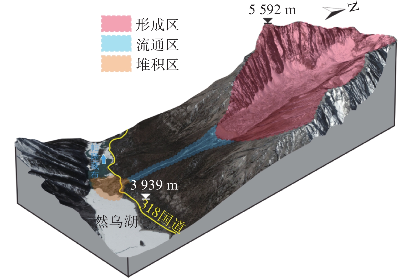
表 1 82道班流域分区基本信息
Table 1 Basic information of 82 road class
分区名称 面积/km2 主沟长/m 平均纵比降/‰ 形成区 9.13 4 507 217.50 流通区 0.49 1 684 377.62 堆积区 0.036 527 64.61 表 2 帕隆藏布卫星数据信息
Table 2 Data information of Palongzangbu satellite
光学卫星数据源 覆盖率/% 数据时间 云覆盖 雪覆盖 Landsat-8 100 2017-11-20—2020-11-20 <1% <5% 资源一号 30.03 2020-01-14—2020-11-10 <1% <5% 资源三号 94.30 2016-11-10—2020-11-12 <1% <5% 高分一号 100 2014-11-29—2020-11-14 <1% <5% 高分二号 53.47 2015-09-30—2020-11-15 <1% <5% 高分六号 90.51 2019-03-29—2020-11-20 <1% <5% 高分七号 17.31 2020-04-13—2020-11-11 <1% <5% TH01 17.96 2019-01-02—2019-01-11 <1% <5% 珠海一号 77.99 2018-12-09—2020-03-31 <1% <5% 表 3 然乌湖口地质灾害光学遥感数据
Table 3 Optical remote sensing data of geological hazards in Ranwu Lake Estuary
序号 时间 数据来源 分辨率/m 备注 1 早期 雅虎影像 2.0 融合数据 2 近期 Google地球 1.0 融合数据 3 2020-10-29 无人机影像 0.15 泥石流中下段 表 4 然乌湖口高位冰崩物源统计表
Table 4 Statistics of high-level ice debris sources in Ranwu Lake Estuary
编号 面积/m2 前缘
高程/m后缘
高程/m前后缘
高差/m距沟口
高差/mBC01 117 185.75 4 929 5 296 367 1 369 BC02 64 032.728 5 046 5 165 119 1 238 BC03 46 066.955 4 995 5 094 99 1 167 BC04 36 014.778 5 159 5 281 122 1 354 BC05 27 004.282 5 035 5 251 216 1 324 BC06 55 548.666 5 170 5 235 65 1 308 表 5 然乌湖口高位崩塌、冰碛物统计表
Table 5 Statistics of high level collapses and moraines in Ranwu Lake Estuary
编号 物源类型与分布 面积/m2 B01 崩塌堆积/ 34 007 崩源区 92 675 B02 崩塌堆积/ 117 392 崩源区 308 142 B03 崩塌堆积/ 860 崩源区 13 099 B04 崩塌堆积/ 1 823 崩源区 50 223 B05 崩塌堆积/ 6 749 崩源区 238 141 B06 崩塌堆积/ 5 458 崩源区 251 888 B07 崩塌堆积/ 37 214 崩源区 99 637 B08 崩塌堆积/ 7 554 崩源区 51 521 B09 崩塌堆积/ 31 383 崩源区 101 061 B10 崩塌堆积/ 10 777 崩源区 67 932 B11 崩塌堆积/ 39 192 崩源区 210 429 B12 崩塌堆积/ 32 823 崩源区 39 066 B13 崩塌堆积/ 14 445 崩源区 19 994 B14 崩塌堆积/ 131 017 崩源区 714 128 B15 崩塌堆积/ 77 610 崩源区 177 990 B16 崩塌堆积/ 79 078 崩源区 311 705 B17 崩塌堆积/ 12 208 崩源区 153 766 BQ01 冰碛物 2 416 559 BQ02 冰碛物 406 753 表 6 然乌湖口崩滑物源统计表
Table 6 Statistics of avalanche source in Ranwu Lake Estuary
编号 面积/m2 BH01 1 015 BH02 467 BH03 2 052 BH04 352 BH05 596 BH06 839 BH07 378 BH08 507 BH09 731 BH10 3 858 BH11 460 BH12 1 465 BH13 2 001 -
[1] 李吉均, 文世宣, 张青松, 等. 青藏高原隆起的时代、幅度和形式的探讨[J]. 中国科学,1979(6):608 − 616. [LI Jijun, WEN Shixuan, ZHANG Qingsong, et al. The discussion on the age, amplitude and form of the uplift of the Qinghai-Tibet Plateau[J]. Science China,1979(6):608 − 616. (in Chinese) [2] 彭建兵, 马润勇, 卢全中, 等. 青藏高原隆升的地质灾害效应[J]. 地球科学进展,2004(3):457 − 466. [PENG Jianbing, MA Runyong, LU Quanzhong, et al. Geological hazards effects of uplift of Qinghai-Tibet Plateau[J]. Advance in Earth Sciences,2004(3):457 − 466. (in Chinese with English abstract) DOI: 10.3321/j.issn:1001-8166.2004.03.018 [3] 高波, 张佳佳, 王军朝, 等. 西藏天摩沟泥石流形成机制与成灾特征[J]. 水文地质工程地质,2019,46(5):144 − 153. [GAO Bo, ZHANG Jiajia, WANG Junchao, et al. Formation mechanism and disaster characteristic of debris flow in the Tianmo gully in Tibet[J]. Hydrogeology & Engineering Geology,2019,46(5):144 − 153. (in Chinese with English abstract) [4] 余忠水, 德庆卓嘎, 罗布次仁, 等. 西藏波密县天摩沟“9·4”特大泥石流灾害成因初步分析[J]. 中国地质灾害与防治学报,2009,20(1):6 − 10. [YU Zhongshui, DE QING Zhuoga, LUOBU Ciren, et al. Preliminary analysis about the cause of “9·4” debris flow disaster in Tian mo gou, Bomi, Tibet[J]. The Chinese Journal of Geological Hazard and Control,2009,20(1):6 − 10. (in Chinese with English abstract) DOI: 10.3969/j.issn.1003-8035.2009.01.002 [5] 施雅风, 杨宗辉, 谢自楚, 等. 西藏古乡地区的冰川泥石流[J]. 科学通报,1964(6):542 − 544. [SHI Yafeng, YANG Zonghui, XIE Zichu, et al. Glacier debris flow in Guxiang area, Tibet[J]. Chinese Science Bulletin,1964(6):542 − 544. (in Chinese with English abstract) [6] 郭柳平, 叶庆华, 姚檀栋, 等. 基于GIS的玛旁雍错流域冰川地貌及现代冰川湖泊变化研究[J]. 冰川冻土,2007(4):517 − 524. [GUO Liuping, YE Qinghua, YAO Tandong, et al. The glacial landforms and the changes of glacier and lake area in the Mapam Yumco Basin in Tibetan Plateau based on GIS[J]. Journal of Glaciology and Geocryology,2007(4):517 − 524. (in Chinese with English abstract) DOI: 10.3969/j.issn.1000-0240.2007.04.003 [7] 隋志龙, 李德威, 黄春霞. 断裂构造的遥感研究方法综述[J]. 地理学与国土研究,2002(3):34 − 37. [SUI Zhilong, LI Dewei, HUANG Chunxia. The review of remote sensing research methods of fault structures[J]. Geography and Territorial Research,2002(3):34 − 37. (in Chinese with English abstract) [8] 张明华. 西藏墨脱公路工程地质灾害遥感勘察与解译方法[J]. 中国地质灾害与防治学报,2005(3):54 − 58. [ZHANG Minghua. Remote sensing image recognizing and interpreting for geological disasters in Motuo highway engineering of Tibet[J]. The Chinese Journal of Geological Hazard and Control,2005(3):54 − 58. (in Chinese with English abstract) DOI: 10.3969/j.issn.1003-8035.2005.03.012 [9] 张瑞丝, 陈建平, 曾敏. 基于Worldview-Ⅱ遥感影像的西藏改则地区断裂构造解译研究及应用[J]. 遥感技术与应用,2012,27(2):265 − 274. [ZHANG Ruisi, CHEN Jianping, ZENG Min. The study of structural interpretation based on Worldview-Ⅱ remote sensing image in Gaize, Tibet and its application[J]. Remote Sensing Technology and Application,2012,27(2):265 − 274. (in Chinese with English abstract) DOI: 10.11873/j.issn.1004-0323.2012.2.265 [10] 王治华. 滑坡、泥石流遥感回顾与新技术展望[J]. 国土资源遥感,1999(3):10 − 15. [WANG Zhihua. Reviewing and prospecting for applying remote sensing to landslide and debrisflow investigation[J]. Remote Sensing for Land & Resources,1999(3):10 − 15. (in Chinese with English abstract) [11] 吕杰堂, 王治华, 周成虎. 西藏易贡滑坡堰塞湖的卫星遥感监测方法初探[J]. 地球学报,2002(4):363 − 368. [LYU Jietang, WANG Zhihua, ZHOU Chenghu. A tentative discussion on the monitoring of the Yigong landslide-blocked lake with satellite remote sensing technique[J]. Acta Geoscientica Sinica,2002(4):363 − 368. (in Chinese with English abstract) DOI: 10.3321/j.issn:1006-3021.2002.04.014 [12] 李远华, 姜琦刚. 基于遥感调查与GIS分析的林芝地区地质灾害评价[J]. 国土资源遥感,2006(2):57 − 60. [LI Yuanhua, JI Qigang. The estimation of regional geo-hazards based on reinvestigation and GIS analysis[J]. Remote Sensing for Land & Resources,2006(2):57 − 60. (in Chinese with English abstract) [13] 王高峰, 唐川, 王洪德, 等. 基于RS和GIS的雅鲁藏布江林芝-加查段沿线泥石流源地物源分析[J]. 水土保持通报,2012,32(1):10 − 13. [WANG Gaofeng, TANG Chuan, WANG Hongde, et al. RS and GIS based analysis of material sources in debris flow origin areas along Linzhi-Jiacha section in Yarlung Zangbo River[J]. Bulletin of Soil and Water Conservation,2012,32(1):10 − 13. (in Chinese with English abstract) [14] 刘洋. 基于RS的西藏帕隆藏布流域典型泥石流灾害链分析[D]. 成都: 成都理工大学, 2013. LIU Yang. Research on the typical debris flows chain based on RS in Palongzangbu Basin of Tibet [D]. Chengdu: Chengdu University of Technology, 2013. (in Chinese with English abstract)
[15] 杨东旭, 游勇, 王军朝, 等. 藏东南帕隆藏布流域冰碛物典型特征及工程效应[J]. 防灾减灾工程学报,2020,40(6):841 − 851. [YANG Dongxu, YOU Yong, WANG Junchao, et al. Characteristics of typical glacial tills in Parlung Zangbo Basin in Southeastern Tibet and its engineering effect[J]. Journal of Disaster Prevention and Mitigation Engineering,2020,40(6):841 − 851. (in Chinese with English abstract) [16] 施雅风, 刘时银. 中国冰川对21世纪全球变暖响应的预估[J]. 科学通报,2000(4):434 − 438. [SHI Yafeng, LIU Shiyin. The prediction of China glacier response to global warming in the 21st Century[J]. Chinese Science Bulletin,2000(4):434 − 438. (in Chinese with English abstract) DOI: 10.3321/j.issn:0023-074X.2000.04.021 [17] 杨威, 姚檀栋, 徐柏青, 等. 近期藏东南帕隆藏布流域冰川的变化特征[J]. 科学通报,2010,55(18):1775 − 1780. [YANG Wei, YAO Tandong, XU Boqing, et al. Characteristics of recent temperat glacier fluctuations in the Parlang Zangbo River basin, soutbeast Tibetan Plateau[J]. Chinese Science Bulletin,2010,55(18):1775 − 1780. (in Chinese with English abstract) DOI: 10.1360/csb2010-55-18-1775 [18] 张斌斌. 帕隆藏布流域海洋性冰川区泥石流特征研究[D]. 成都: 西南交通大学, 2016. ZHANG Binbin. Study on debris flow characteristics in temperate glacier area of Pallon Tsangpo [D]. Chengdu: Southwest Jiaotong University, 2016. (in Chinese with English abstract)
[19] 高杨, 李滨, 高浩源, 等. 高位远程滑坡冲击铲刮效应研究进展及问题[J]. 地质力学学报,2020,26(4):510 − 519. [GAO Yang, LI Bin, GAO Haoyuan, et al. Progress and issues in the research of impact and scraping effect of high-elevation and long-runout landslide[J]. Journal of Geomechanics,2020,26(4):510 − 519. (in Chinese with English abstract) [20] 马泽平. 川藏交通廊道冰碛物工程性质研究[D]. 成都: 西南交通大学, 2013. MA Zeping. Study on engineering properties of the moraine in Sichuan-Tibet transportation corridor [D]. Chengdu: Southwest Jiaotong University, 2013. (in Chinese with English abstract)
[21] 杨栋, 王军朝, 杨东旭. 帕隆藏布流域冰碛物斜坡结构及稳定性评价方法[J]. 人民长江,2019,50(1):108 − 112. [YANG Dong, WANG Junchao, YANG Dongxu. Moraine slope structure in Parlung Zangbo River Basin and its stability evaluation method[J]. Yangtze River,2019,50(1):108 − 112. (in Chinese with English abstract) [22] BURBNK D W, ANDERSON R S. Tectonic Geomorphology[J]. Progress in Physical Geography,1991,15(2):193 − 205. DOI: 10.1177/030913339101500206
[23] SU Z, SHI Y,et al. Response of monsoonal temperate glaciers to global warming since the Little Ice Age[J]. Quaternary International,2002,97(98):123 − 131.
[24] FUJITA K, AGETA Y. Effect of summer accumulation on glacier mass balance on the Tibetan Plateau revealed by mass-balance model[J]. Journal of Glaciology,2000,46(153):244 − 252. DOI: 10.3189/172756500781832945
[25] INTRIERI E, FRASPINI, FUMAGALLI A, et al. The Maoxian landslide as seen from space: detecting precursors of failure with Sentinel-1 data[J]. Landslides,2017,15(1):123 − 133.
[26] ZHAO CY, ZHONG L, et al. Large-area landslide detection and monitoring with ALOS/PALSAR imagery data over Northern California and Southern Oregon, USA[J]. Remote Sens Environ,2012,124:348 − 359.
[27] 周学铖, 廖黎明. 西藏萨迦县地质灾害危险性评价[J]. 中国地质灾害与防治学报,2019,30(6):113 − 116. [ZHOU Xuecheng, LIAO Liming. Geological hazard assessment in Sakya County of Tibet Autonomous Region[J]. The Chinese Journal of Geological Hazard and Control,2019,30(6):113 − 116. (in Chinese with English abstract) -
期刊类型引用(26)
1. 李超然,袁广祥. 甘肃省宕昌县地质灾害易发性评价. 地质灾害与环境保护. 2025(01): 21-25 .  百度学术
百度学术
2. 兰盈盈,郭昶成,朱云福. 地质灾害易发性评价方法综述. 地质与资源. 2024(01): 65-73 .  百度学术
百度学术
3. 杨晶晶,肖玉,安泉,刘浩,公斌. 黔东北地区地质灾害时空分布规律及孕灾地质环境研究. 中国煤炭地质. 2024(02): 64-68 .  百度学术
百度学术
4. 李晓玮,刘翠娜. 基于AHP法山区公路边坡稳定性评价及危害性分析. 河北地质大学学报. 2024(02): 61-65+134 .  百度学术
百度学术
5. 南赟,翟淑花,李岩,曹颖,罗守敬,王云涛,郭学飞. 北京地区“23·7”特大暴雨型地质灾害特征及预警成效分析. 中国地质灾害与防治学报. 2024(02): 66-73 .  本站查看
本站查看
6. 曾欣,黄梦妮,胡毓灵,邓新林,谢倩雯. 株洲市地质灾害特征与降雨量的关系. 气象研究与应用. 2024(01): 83-89 .  百度学术
百度学术
7. 唐朝. 基于ArcGIS的当涂县地质灾害风险调查与评价. 现代矿业. 2024(04): 187-190+196 .  百度学术
百度学术
8. 蔡佳明. 北京东部山区地质灾害危险性评价. 地质灾害与环境保护. 2024(02): 49-55 .  百度学术
百度学术
9. 李晓玮. 北京北宫镇大灰厂路牵引式岩质滑坡勘查及防治对策. 城市地质. 2024(02): 139-148 .  百度学术
百度学术
10. 赵丹凝,焦润成,杨春. “23·7”强降雨对北京西山曹家坊泥石流隐患易发性影响. 城市地质. 2024(03): 353-364 .  百度学术
百度学术
11. 尹展,郝玉军,卜鹏,杨艳绪. 湘南中低山区滑坡孕灾因子分析及易发性评价——以江华县为例. 矿产勘查. 2024(10): 1878-1884 .  百度学术
百度学术
12. 李晓玮,郑晓钰,史昕宇. 北京西部采空区初勘及场地适宜性评价. 防灾减灾学报. 2024(04): 7-12 .  百度学术
百度学术
13. 支泽民,刘峰贵,周强,夏兴生,陈琼. 基于流域单元的地质灾害易发性评价——以西藏昌都市为例. 中国地质灾害与防治学报. 2023(01): 139-150 .  本站查看
本站查看
14. 王涛,李鹏洋,逯兴娅,苏生瑞,董永超. 陕西省韩城市地质灾害易发性评价. 甘肃科学学报. 2023(02): 55-62 .  百度学术
百度学术
15. 张群,冯辉,贾三满,张沁瑞,贾磊. 基于CF与Logistic回归模型耦合的地质灾害易发性评价——以北京市大清河流域生态涵养区为例. 城市地质. 2023(01): 17-25 .  百度学术
百度学术
16. 罗琳,刘雄,翁建,王锦阳,楼雄标. 某乡镇地质灾害风险评价. 科技通报. 2023(04): 93-102 .  百度学术
百度学术
17. 孙佩,杨良哲,康全国,张驰,尹伟,周凌云,易洁伟,王雯雯. 一般调查区地质灾害易发性评价——以咸丰县为例. 资源信息与工程. 2023(04): 95-98 .  百度学术
百度学术
18. 叶泽宇,徐尚智,刘欢欢,于家烁,翟淑花,冒建. 基于信息量与逻辑回归耦合模型的北京西山崩塌易发性评价. 城市地质. 2023(03): 9-15 .  百度学术
百度学术
19. 阳清青,余秋兵,张廷斌,易桂花,张恺. 基于GDIV模型的大渡河中游地区滑坡危险性评价与区划. 中国地质灾害与防治学报. 2023(05): 130-140 .  本站查看
本站查看
20. 王海芝,曾庆利,许冰,胡福根,于淼. 北京“7·21”特大暴雨诱发的地质灾害类型及其特征分析. 中国地质灾害与防治学报. 2022(02): 125-132 .  本站查看
本站查看
21. 焦伟之,张明,谢鑫鹏,李成文,刘涛,庞海松. 基于GIS与加权信息量模型的城镇地质灾害易发性评价——以大新镇为例. 安全与环境工程. 2022(04): 119-128 .  百度学术
百度学术
22. 简鹏,李文彦,张治家,时伟,党发宁,郭红东,李松. 基于多因素加权指数和法的区域地质灾害易发性评价研究——以麦积区为例. 甘肃地质. 2022(03): 63-72 .  百度学术
百度学术
23. 白光顺,杨雪梅,朱杰勇,张世涛,祝传兵,康晓波,孙滨,周琰嵩. 基于证据权法的昆明五华区地质灾害易发性评价. 中国地质灾害与防治学报. 2022(05): 128-138 .  本站查看
本站查看
24. 庄卓涵. 广州北部山区斜坡类地质灾害致灾机理及易发性分析——以广州从化良口—吕田一带为例. 地下水. 2022(06): 158-161 .  百度学术
百度学术
25. 王小东,罗园,付景保. 基于GIS的白龙江引水工程水源区地质灾害易发性评价. 南水北调与水利科技(中英文). 2022(06): 1231-1239 .  百度学术
百度学术
26. 郭富赟,宋晓玲,刘明霞. 黄河流域甘肃段地质灾害发育特征. 中国地质灾害与防治学报. 2021(05): 130-136 .  本站查看
本站查看
其他类型引用(6)


 下载:
下载:




 邮件订阅
邮件订阅 RSS
RSS