

Extraction of eucalyptus trees along railway lines based on decision tree classification and identification of potential landslides: A case study along Guangxi section of the Guizhou—Guangxi Railway
-
摘要:
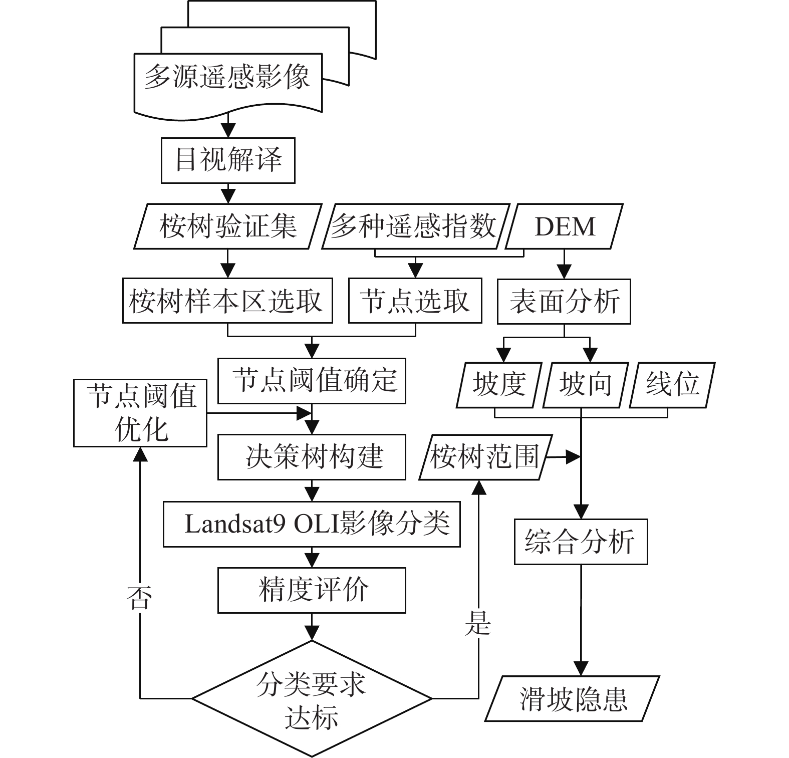
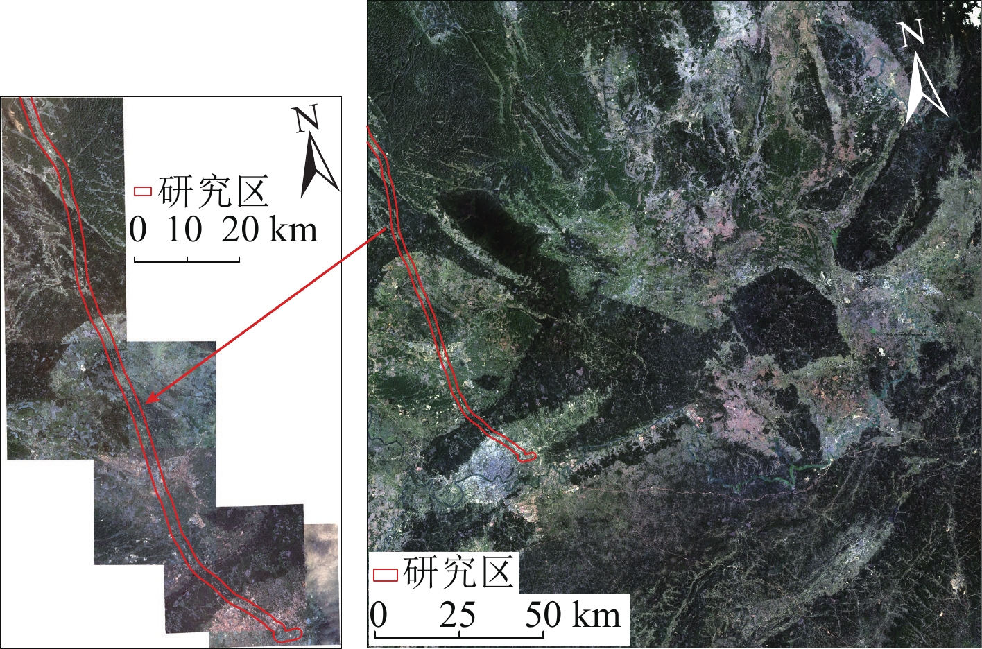
桉树因生长习性特殊,会导致土壤的肥料和养分流失,引发土地退化,造成滑坡等地质灾害。广西地区气候条件适宜,区域内铁路沿线种植有大量桉树,致使铁路沿线存在滑坡隐患。为了对铁路沿线的滑坡隐患进行超前识别,文章以贵南高铁广西段为例,基于Landsat9 OLI、GF-7影像和DEM数据,使用决策树分类算法提取铁路沿线1 km缓冲区内桉树种植范围,再综合地形地貌等因素进行分析,识别出滑坡隐患。研究结果表明:(1)文章构建的决策树分类算法较其他方法来说,分类精度有所提升,总体分类精度平均值达到87.19%,Kappa系数平均值达到0.80,表明该方法在研究区内能有效提取桉树的范围;(2)贵南高铁广西段沿线大量种植桉树,桉树林呈片状分布在山丘地区,铁路沿线1 km缓冲区内桉树种植面积约为14.48 km2;(3)研究区内桉树的种植对铁路的桥梁、路基和隧道口存在一定影响,文章识别出的滑坡隐患共33处,经过现场核查准确率达到86.84%。通过以上方法可有效地对铁路沿线桉树种植范围进行提取,综合地质因素后可做到滑坡隐患的超前识别,提高了铁路的行车安全。
Abstract:The unique growth characteristics of eucalyptus can result in the depletion of soil nutrient and fertilizers, leading to land degradation and geological hazards like landslides. The Guangxi region in China has suitable climatic conditions, and numerous eucalyptus are strategically planted along railway lines, posing the risk of potential landslides. To proactively identify potential landslides along railway lines, this study takes the Guangxi section of the Guizhou-Guangxi high-speed railway as a case study. Based on Landsat 9 OLI, GF-7 imagery, and DEM data, a decision tree classification algorithm is employed to extract the planting areas of eucalyptus within a 1 km buffer zone along the railway. Then, comprehensive analysis incorporating terrain and landforms factors is conducted to identify potential landslides hazards. The research findings show that: 1) compared to other methods, the decision tree classification algorithm conducted in this study improves the classification accuracy, with an overall average classification accuracy of 87.19% and an average Kappa coefficient of 0.80, indicating that this method can effectively extract the range of eucalyptus in the study area; 2) A large number of eucalyptus are planted along the Guangxi section of the Guinan high-speed railway, with eucalyptus distributed in patches in hilly areas. The eucalyptus planting area within the 1 km buffer zone along the railway is approximately 14.48 km2; 3) The planting of eucalyptus in the study area has a certain impact on the bridges, emban kments, and tunnel entrances of the railway. A total of 33 potential landslides were identified in this study, with an accuracy rate of 86.84% through field verification. The above method can effectively extract the planting range of eucalyptus along the railway line, and combined with geological factors, it can proactively identify potential landslides, enhancing the safety of railway operation.
-
0. 引言
地质灾害气象风险预警是基于气象降雨因素引发地质灾害的区域性预警,是通过分析孕育地质灾害的地质特征与引发地质灾害的降水特征建立模型算法,在地质灾害易发性基础上,结合前期过程降雨和未来预报降雨,对一定区域在未来一段时间内发生地质灾害的可能性及成灾风险进行预报预警。近20年的实践表明,地质灾害气象风险预警在防御地质灾害中发挥着“指挥棒”的作用,是地质灾害风险管控的行之有效的手段。
对降雨引发的地质灾害区域预警研究,广大学者开展了大量的研究和探索。美国地质调查局1969年完成了基于泥石流临界降雨强度预警系统的开发;1985年进行了区域内大暴雨与滑坡灾害的统计分析,建立了滑坡与降雨强度的临界降雨模型,并研发了早期的滑坡灾害预警系统[1];日本学者通过对流域实况降雨与地下水渗流场分析,研究确定泥石流发生的临界降雨阈值,并实现了自动预警;学者Flentje、Chowdhury、Crozier、Emmanuel Gabet、Aleotti、Enrico Gregori等也在实时预警方面做了大量的探索工作[2 − 3]。刘传正等[4 − 5]将区域预警理论原理分为隐式统计预警、显式统计预警和动力预警三大类,并针对显式统计预警模型提出了地质灾害区域“发育度”、“潜势度”、“危险度”、“风险度”和“危害度”等“五度”递进分析理论方法。刘艳辉等[6]在显式统计预警模型中采用确定系数方法实现了区域预警潜势度的计算,解决了地质灾害区域预警模型方法的难题,地质灾害气象预警工作逐步在全国山区省、市、县开展。以上研究成果多偏重于技术层面,对地质灾害防治管理体制机制方面的探索涉及较少。
在近20年的地质灾害气象风险预报预警工作实践中,因缺少统一的系统建设标准和成果发布规范,这种省、市、县各自建设的地质灾害气象预警系统经常会出现结果不统一、数据共享难、更新时效差、平台功能不完善等问题,导致同区域同时段出现不同预警等级和重复预警的现象,给基层应急响应和防灾处置工作带来一定困扰,对预警信息发布的严肃性和权威性造成不利影响[7 − 11]。2018年以来,浙江、四川、福建、云南等省份率先探索地质灾害省-市-县一体化预警平台建设,在数据资源高效共享、预警结果同台会商、预警信息统一发布等方面取得了较大进步,形成了不同模式的省-市-县一体化地质灾害风险预警体系。下面以浙江省为例介绍省-市-县一体化地质灾害风险预警系统建设。
1. 工作概况
1.1 浙江省地质背景及地质灾害概况
浙江省地处我国东南沿海,地貌类型多样,主要以中低山丘陵为主;地质构造复杂,以江山-绍兴深断裂带为界,横跨“扬子台地”(江南地层区)和“华南褶皱系”(华南地层区)两大Ⅰ级地质构造单元;降雨丰沛,梅汛期降雨持续时间长,台风降雨强度大。同时,人类工程活动强烈、人口密度大,容易引发地质灾害。浙江省地质灾害易发区占到全省陆域面积的73%(图1),地质灾害规模虽以小型为主,但时常造成较大的人员伤亡和经济损失。据统计,全省已发生突发性地质灾害灾情6343处,造成296人死亡、15人失踪、102人受伤,直接经济损失10.17亿元。截至2023年11月,全省现有地质灾害隐患点422处,地质灾害风险防范区16934处,威胁6.99万户22.2万人,威胁财产173.8亿元。
1.2 地质灾害预警工作概况
2003年浙江省自然资源厅与省气象局联合开展地质灾害预报预警工作,截至2023年,全省因地质灾害预警成功避险地质灾害532起,避免人员伤亡5564人,避免经济损失6252.5万元,取得了良好成效。为提升地质灾害预报预警精准度,2005年完成了市级1∶5万市级地质灾害预警系统,实现了省、市地质灾害分级预报预警;2007年为强化山区实况降雨对地质灾害的影响,将水利部门监测实况雨量纳入地质灾害预警系统,提升了地质灾害预报预警精度;2009年为有效防范局地强降雨引发地质灾害,研发了3 h短临预警系统;2013年针对预警对象研发了全国首个基于斜坡单元的地质灾害预警系统[12];2019年为进一步提升预警精度,采用均一单元升级了地质灾害预警系统[13];2020年,自然资源部在浙江实施地质灾害风险隐患“双控”试点,针对新调查的地质灾害风险防范区研发了以临界降雨为基础的1 h实时预警系统[14]。同时,将24 h每日预报、3 h短临预报和1 h的实时预警三种模式的地质灾害气象风险预报预警模型,并按照“省级预报到县、市级预报到乡、县级预警到村(点)”的工作原则,初步建成了省-市-县一体化地质灾害气象风险预报预警系统[15],并制定了《浙江省突发性地质灾害风险预报预警技术要求(试行)》,对全省地质灾害预报预警业务进行了规范。
2. 地质灾害风险预警一体化建设
2.1 预警工作内容
浙江省地质灾害气象风险预报预警时间尺度如图2所示,可分为趋势预测、等级预报和实时预警三类。
(1)趋势预测:根据气象部门阶段性降雨预测,按年度、季度、月度及重点时段(节假日和重要活动等)开展地质灾害风险趋势预测,研究确定本阶段是否可能存在地质灾害风险较高及以上区域、重点风险地段和风险点,以及相应时段,并提出本阶段地质灾害防范工作建议。
(2)风险预报:包括未来24 h地质灾害气象风险等级预报和未来3 h短临预报。根据气象部门未来24 h预报雨量和前期实况雨量,结合地质环境条件开展地质灾害风险区域预报,提醒预报区域防灾管理人员及时开展地质灾害防范工作;强降雨时段,结合实际工作需求,加密预报频次,根据气象部门未来3 h预报雨量和前期实况雨量,开展地质灾害气象风险3 h短临预报;台风暴雨时段开展48/72 h短期风险预报。风险预报为区域概率预报,预报层级最小到乡镇级。
(3)实时预警:通过研究设定地质灾害隐患点和风险防范区降雨阈值,结合周边雨量监测站监测的实时降雨开展地质灾害风险实时预警,并向地质灾害隐患点和风险防范区管理人员逐小时发布风险预警信息,指导基层开展地质灾害巡查和受威胁人员转移避险。实时预警是对区域概率预报的补充和矫正。
通过全面梳理省、市、县三级地质灾害风险预报预警业务工作需求,我省确定“省预报到县,市预报到乡,县预警到村(点)”的工作要求,省、市自然资源主管部门结合预报产品,以行政区划为单位,发布风险“五色图”,提醒各级部门依据工作职责,做好地质灾害防治工作;县级自然资源主管部门对地质灾害风险防范区和隐患点开展实时预警,实时发布风险预警信息,精准指导地质灾害影响人员转移避险,工作体系架构见图3。
![]() 图 3 预报预警工作结构框架图Figure 3. Structure framework diagram of forecast and early warning work
图 3 预报预警工作结构框架图Figure 3. Structure framework diagram of forecast and early warning work2.2 通用模型算法
通用模型是在全省地质灾害基础上统一研发的地质灾害气象风险预报预警模型,各市可直接调用,也可自行研发不同的预报预警模型。通用模型主要是通过区域地质灾害机理研究,确定地质灾害敏感因子和诱发因子,应用相关性原理建立地质灾害易发性评价指标体系,综合评价不同区域地质灾害易发程度,结合地质灾害与降雨量的关系分析,基于逻辑回归的概率预报方法,构建地质灾害气象风险预报预警模型,包含省市3 h短时预报、24 h常规预报、48/72 h趋势预测模型,开展区域地质灾害风险等级预报。县级实时预警模型主要面向地质灾害风险防范区和隐患点开展,根据降雨强度-历时(I-D曲线)确定临界降雨阈值,利用实时降雨与临界降雨阈值判别矩阵开展实时预警工作。
2.2.1 省市等级预报模型方法
省级预报模型主要采用主成分逻辑回归方法(图4),以地质灾害赋存环境条件均一的不规则单元为预报对象,对已发生地质灾害影响因子进行主成分分析,最终确定坡度、坡向、高程、地层岩性、断裂构造、工程地质岩组,土地利用及植被类型共8个因子作为地质灾害敏感因子。其中省级预报模型以全省山地丘陵区为地质灾害预报预警范围构建32.5万余评价单元,对预警单元进行地质灾害危险性指标(G)进行计算,通过危险度与降雨条件(降水指数)的相关及回归分析,确立预警指数数学表达式(式1)。
![]() 图 4 地质灾害气象风险预报模型方法Figure 4. Methodology of geological hazard meteorological risk prediction model
图 4 地质灾害气象风险预报模型方法Figure 4. Methodology of geological hazard meteorological risk prediction model$$ T={k}_{0}G+{k}_{1}({R}_{{\mathrm{a}}}+{R}_{{\mathrm{f}}})/{R}_{0}+e $$ (1) 式中:
$ T $ ——预警指数;${G} $ ——地质灾害危险性指标;$ {R}_{{\mathrm{a}}} $ ——前期有效降雨;$ {R}_{{\mathrm{f}}} $ ——预报降雨;$ {R}_{0} $ ——降雨区划;$ {k}_{0} $ 、$ {k}_{1} $ ——回归系数;e——修正值。
经过统计分析,浙江省大部分地质灾害均在强降雨当天发生,而地质灾害发生前3 d有降雨的占83.9%,前7 d累计降雨与地质灾害发生数相关程度非常高[7]。根据实际降雨与地质灾害发生情况复盘分析,短临预报通常考虑前24 h有效雨量,每日预报和短期预报考虑前7日累计有效雨量符合浙江省地质灾害发生与降雨强度规律[12 − 13]。
市级预报模型除宁波采用斜坡单元外,其余均采用200~500 m精度的网格单元,因东西部地质条件差异和降雨类型(台风暴雨和梅雨)不同,采用的地质灾害影响因子和前期降雨稍有不同,均采用逻辑回归的方法建立市级预报模型。
2.2.2 县级实时预警模型方法
预警模型主要采用降雨强度-历时(I-D曲线)的临界降雨阈值方法[14 − 16]。浙江省以县级行政区划为单元,统计分析历史发生的地质灾害降雨强度(I)和降雨历时(D)的关系,在对数坐标下,以数据分布(式2)的下限作为该县(市、区)的降雨阈值曲线(I-D曲线),并根据该曲线,提取不同历时(1 h、3 h、6 h、12 h、24 h)的黄、橙、红临界降雨阈值来实施地质灾害实时预警(图5)。目前,依托乡镇地质灾害风险调查项目,根据地质灾害体的破坏和变形情况、受灾体的风险承受差异等指标,逐步实现更为精细的“一坡一阈值”风险动态调整机制。
![]()
$$ R(H)=a{H}^{b} $$ (2) 式中:
$ R(H) $ ——降雨强度;$ H $ ——降雨时长;$ a $ ——比例系数;$ b $ ——幂指数。2.3 预警系统建设
根据地质灾害气象风险预警业务需求,采用节点建设模式,基于云计算技术研发了省市县一体化预报预警平台,平台由数据中心、数据中台及应用场景组成。数据中心主要负责数据采集、存储和管理等,包含数据仓、模型仓、功能仓和节点仓,每个节点仓保存各自的业务库、雨量库和成果库;数据中台主要负责数据调用、治理和共享,为全省预报预警一体化业务提供数据节点管理、功能调用、综合展示、运维监控和共享管理等功能;应用场景包括等级预报子系统、实时预警子系统、其他预警子系统和会商平台[15]。平台基础设施如服务器、网络及安全防护等资源由省级统一建设,市县级应用场景按照标准格式,调用省数据中心数据,结合当地气象、水利部门降雨数据进行地质灾害等级预报和实时预警,并将预警响应数据反馈数据中心,形成闭环管理。系统实现了跨部门多层级业务融合和数据共性支撑全省复用,同时,预报预警产品通过数据服务接口,实时为地质灾害防治业务场景、防汛防台在线等提供预警成果共享服务。
2.3.1 等级预报子系统
等级预报子系统主要在建设省、市两级,是开展地质灾害区域风险分析的专业系统,包含数据获取处理、模型分析计算、人工会商干预、预报产品制作和预报产品发布等功能。各级子系统通过专线将各级气象降雨预报数据导入数据中心,通过模型计算形成初级预报结果,上传会商中心进行全省会商研判,各市根据研判结果分别制作市、县预报产品进行发布,省级部门对各市产品进行综合,形成地质灾害风险等级预报“五色图”进行发布。同时,省部门根据气象3 h降雨预报数据实施自动化短临预警提醒。
2.3.2 实时预警子系统
实时预警子系统主要建设在县级,是针对地质灾害隐患点、风险防范区和重点乡村进行实时自动化预警,每小时发布风险预警信息。主要功能包括数据获取处理、预警分析研判和预警结果发布等。县级实时预警系统将地质灾害风险防范区或隐患点关联周边气象和水文部门雨量监测站,利用监测降雨量与1 h、3 h、6 h、12 h、24 h的黄、橙、红临界降雨阈值进行对比研判,采用不同历时的最高预警等级作为当前地质灾害风险防范区或隐患点的预警级别,并逐小时更新。
2.3.3 任务闭环和监管系统
为保证地质灾害风险预报预警信息的任务闭环和可视化监管,一体化预警平台研发了风险防控驾驶舱和移动应用终端“地灾智防”APP。通过移动终端,实时查询地质灾害等级预报、实时预警、专业监测预警等预警信息,实现防灾指令的实时贯通和防灾数据的及时汇集;通过驾驶舱大屏,各级自然资源主管部门可以查看台风降雨、等级预报、实时预警、值班值守、巡查排查、驻县进乡、灾险情处置、防治工作等信息,切实提升浙江省地质灾害防治指挥决策的时效性和科学性。
2.3.4 预警闭环管控机制
“省级预报到县、市级预报到乡、县级预警到村(点)”工作体系是浙江省地质灾害气象风险预报预警一体化工作机制的重要内容之一。省级通过一体化平台省级节点,开展3 h、24 h等多时段地质灾害风险等级预报,发布范围覆盖省级有关部门和市、县自然资源主管部门;市级地质灾害风险等级预报成果范围覆盖市级有关部门和县级自然资源主管部门和乡镇(街道);县级通过气象、水利部门的实况降雨数据,结合风险降雨阈值,针对地质灾害隐患点、风险防范区和重点乡村等开展实时预警,发布范围覆盖县级有关部门和乡(镇街道)村(社区)责任人和群测群防员(图6)。
![]() 图 6 一体化地质灾害风险预报预警系统框架图Figure 6. Framework diagram of integrated geological hazard risk forecast and early warning system
图 6 一体化地质灾害风险预报预警系统框架图Figure 6. Framework diagram of integrated geological hazard risk forecast and early warning system“有预警就有响应,有响应务必闭环”是一体化工作机制的另一重要内容,根据省、市、县三级在不同防御阶段的地质灾害风险管控要求,围绕地质灾害风险预报预警结果,移动终端发布预报预警信息,派发巡查处置任务,并回流基层地质灾害防治工作反馈情况,实现地质灾害风险预报预警响应的闭环管控。通过驾驶舱大屏,实现地质灾害风险信息和防治业务信息的可视化展示,消息和任务的全生命周期监控,配合“叫应叫醒”工作机制,保证信息的贯通,落实闭环管理。
3. 典型预警案例
受2023年5号台风“杜苏芮”影响,温州南部地区遭受持续强降雨。2023年7月26日18时,省级预警系统对温州市平阳县发布未来24 h地质灾害气象风险橙色预警,温州市预警系统对平阳县顺溪镇发布未来24 h地质灾害气象风险橙色预警。27日8时省、市预警级别均升级为红色预警(图7),值班人员第一时间电话叫应当地政府主要领导。顺溪镇人民政府立即组织开展隐患点和风险防范区人员转移工作,11时将顺溪镇下东村风险防范区(编号330326FF0263)受威胁的5人提前转移至避灾场所。27日13时县级实时预警系统(基于临界降水阈值模型)对该处风险防范区发布黄色预警,并生成巡查任务,群测群防员立即开展巡查,并通过“地灾智防”APP反馈巡查和人员转移情况。14时省级预警系统对平阳县再次加密发布未来3 h短临红色预警,15时该处专业监测设备也发出红色报警,16时该风险防范区发生滑坡,体积约300 m3。滑坡造成坡脚房屋墙体和窗户局部损毁和屋内泥水淤积(图8)。由于预警及时精准,人员提前撤离,成功避免1户5人伤亡。本起案例是基于省-市-县一体化预警工作体系,逐级逐步精准发布预警信息、有效落实闭环管控、成功避免人员伤亡的典型案例。
![]() 图 7 地质灾害风险预警综合展示图Figure 7. Comprehensive display of geological disaster risk early warning
图 7 地质灾害风险预警综合展示图Figure 7. Comprehensive display of geological disaster risk early warning![]() 图 8 温州市平阳县顺溪镇下东村滑坡Figure 8. Landslide at Xiadong Village, Shunxi Town, Pingyang County, Wenzhou City
图 8 温州市平阳县顺溪镇下东村滑坡Figure 8. Landslide at Xiadong Village, Shunxi Town, Pingyang County, Wenzhou City4. 结论
(1)浙江省通过构建“省级预报到县、市级预报到乡、县级预警到村(到点)”预报预警一体化工作体系,依托“地灾智防”APP等数字化手段,加强了预报预警与预警响应联动,建立预警响应闭环工作机制,实现了地质灾害气象风险预警响应闭环管理。
(2)浙江省通过开展地质灾害气象风险预警一体化建设,在模型构建、系统建设、数据共享和闭环管控机制建设等方面形成了一套较为完整的技术和管理体系,为其他省市开展预警一体化建设提供了较为成熟的应用示范。
(3)浙江省预报预警一体化系统自上线以来,运行效果良好,工作成效显著,有效支撑了全省地质灾害防治工作。但由于预报降雨数据更新和实况降雨数据校正的滞后性,导致地质灾害风险预警结果实时性不足,在与气象、水利部门数据协同机制方面仍需进一步加强。
-
![]()
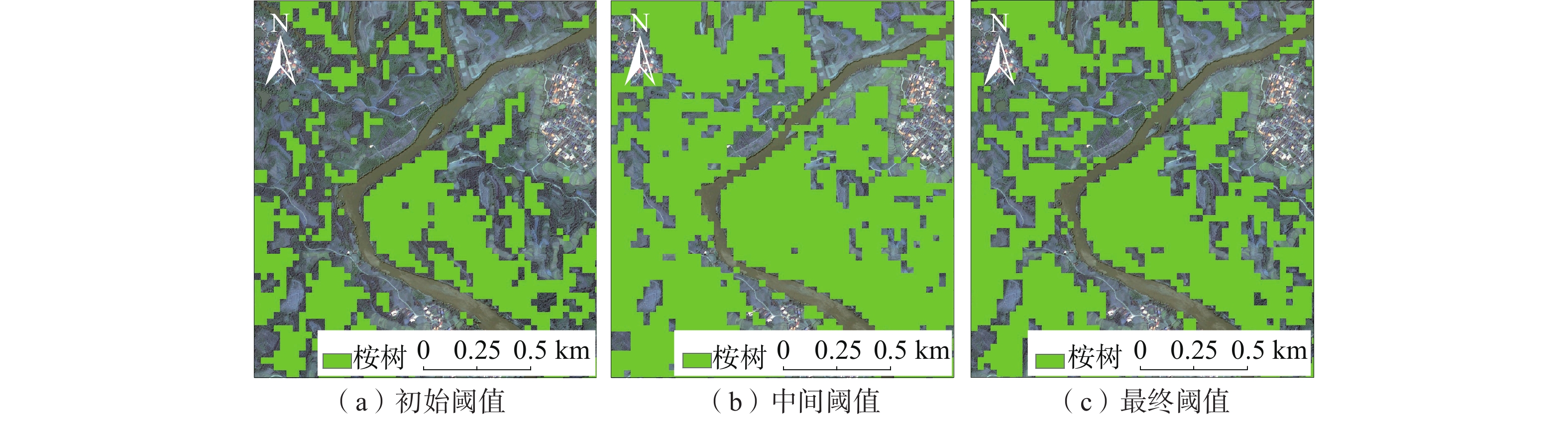
图 3 阈值优化过程中局部范围分类结果
Figure 3. Local area classification results during threshold optimization process
![]()
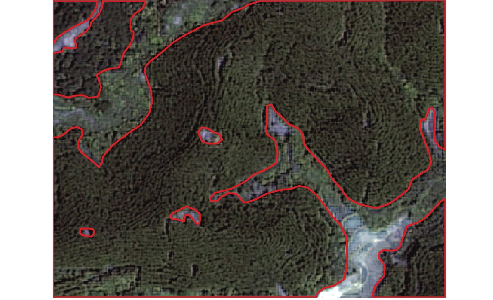
图 6 3种方法在2022年4月9日Landsat9 OLI影像中的分类结果
Figure 6. Classification results of three methods in Landsat9 OLI image on April 9, 2022
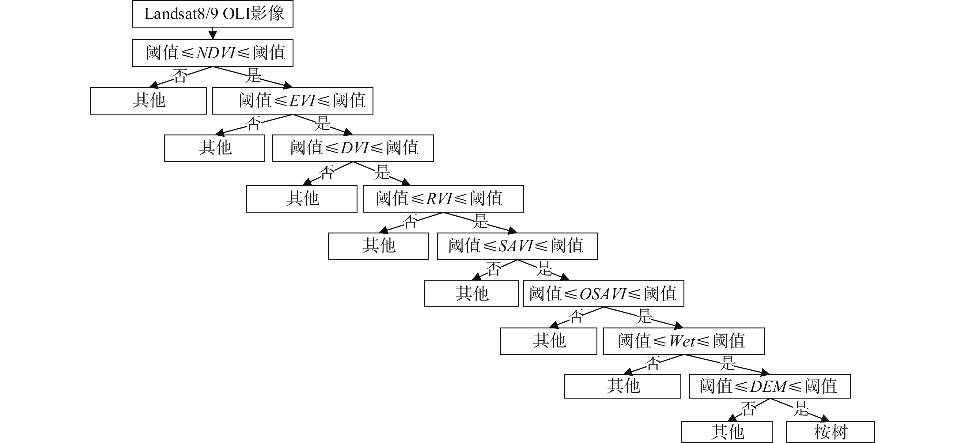
表 1 决策树各类指数信息表
Table 1 Information table of various indices in the decision tree
指数类型 计算公式 NDVI $ NDVI = \dfrac{{NIR - RED}}{{NIR + RED}} $ EVI $ EVI = \dfrac{{2.5(NIR - RED)}}{{NIR + 6RED - 7.5BLUE + 1}} $ DVI $ DVI = NIR - RED $ RVI $ RVI = \dfrac{{NIR}}{{RED}} $ PVI $ PVI = 0.939NIR - 0.344RED + 0.09 $ SAVI $ SAVI = \dfrac{{(1 + 0.5)(NIR - RED)}}{{NIR + RED + 0.5}} $ OSAVI $ OSAVI = \dfrac{{NIR - RED}}{{NIR + RED + 0.16}} $ WET $ \begin{aligned} WET = & 0.151\;1BLUE + 0.197\;3GREEN + 0.328\;3RED + 0.340\;7NIR- \\ & 0.711\;7SWIR1 - 0.455\;9SWIR2 \\ \end{aligned} $ 注:BLUE为蓝光波段,GREEN为绿光波段,RED为红光波段,NIR为近红外波段,SWIR1为短波近红1,SWIR2为短波近红2。  下载: 导出CSV
表 2 决策树各类指数阈值
Table 2 Threshold values of various indices in the decision tree
指数类型 初始阈值 中间阈值 最终阈值 NDVI [0.71, 0.84] [0.52, 0.85] [0.64, 0.85] EVI [0.42, 0.61] [0.31, 0.73] [0.38, 0.65] DVI [0.21, 0.34] [0.14, 0.41] [0.19, 0.36] RVI [6.06, 11.33] [3.21, 12.69] [4.58, 12.08] PVI [0.31, 0.43] [0.25, 0.51] [0.29, 0.47] SAVI [0.41, 0.56] [0.28, 0.62] [0.36, 0.58] OSAVI [0.47, 0.59] [0.33, 0.62] [0.43, 0.61] WET [−0.027, 0.015] [−0.072, 0.023] [−0.045, 0.019]
下载: 导出CSV
表 3 混淆矩阵
Table 3 Summary table of the confusion matrix
分类模型 评价指标 验证区 平均值 1 2 3 CART 总体分类精度/% 87.12 87.27 87.17 87.19 Kappa 0.80 0.80 0.80 0.80 SVM 总体分类精度/% 84.90 85.77 83.52 84.73 Kappa 0.76 0.77 0.74 0.76 NN 总体分类精度/% 84.36 83.15 81.24 82.92 Kappa 0.75 0.73 0.71 0.73
下载: 导出CSV
表 4 坡度等级表
Table 4 The grade table of slope
等级 类型 坡度/(°) 特性 1 较缓坡面 10~15 较稳定,极端天气下可能形成滑坡 2 中等陡峭坡面 15~25 一般稳定,极端天气下易形成滑坡 3 陡峭坡面 25~45 不稳定,易形成滑坡
下载: 导出CSV
表 5 滑坡隐患详情表
Table 5 The detailed table of potential landslides
序号 类型 等级 是否正确 说明 序号 类型 等级 是否正确 说明 序号 类型 等级 是否正确 说明 1 桥梁 1 是 14 隧道 1 是 27 隧道 2 否 零星桉树干扰 2 桥梁 1 是 15 隧道 2 是 28 隧道 2 否 零星桉树干扰 3 隧道 3 是 16 桥梁 2 是 29 桥梁 1 是 4 隧道 2 是 17 路基 2 是 30 隧道 1 是 5 桥梁 1 是 18 路基 1 是 31 隧道 1 是 6 隧道 2 是 19 隧道 2 是 32 路基 2 是 7 隧道 2 是 20 隧道 2 是 33 隧道 2 是 8 隧道 2 否 零星桉树干扰 21 路基 2 是 34 隧道 2 是 9 隧道 2 否 零星桉树干扰 22 路基 1 是 35 路基 3 是 10 隧道 2 是 23 路基 1 是 36 路基 3 是 11 桥梁 2 是 24 路基 1 是 37 隧道 2 是 12 隧道 3 否 地形改变 25 桥梁 1 是 38 隧道 2 是 13 路基 2 是 26 路基 1 是
下载: 导出CSV
-
[1] 杨晓燕,熊炀,宫雪,等. 亚热带地区主要阔叶用材树种的非生物胁迫研究进展[J]. 西南林业大学学报(自然科学),2023,43(3):191 − 204. [YANG Xiaoyan,XIONG Yang,GONG Xue,et al. Advances in abiotic stress of main broad-leaved timber species in subtropical regions[J]. Journal of Southwest Forestry University (Natural Sciences),2023,43(3):191 − 204. (in Chinese with English abstract)] YANG Xiaoyan, XIONG Yang, GONG Xue, et al. Advances in abiotic stress of main broad-leaved timber species in subtropical regions[J]. Journal of Southwest Forestry University (Natural Sciences), 2023, 43(3): 191 − 204. (in Chinese with English abstract)
[2] 王会利,吴秦展,兰文明,等. 多代连栽桉树人工林林下植被和土壤物理性状的变化[J]. 中南林业科技大学学报,2023,43(2):1 − 9. [WANG Huili,WU Qinzhan,LAN Wenming,et al. Dynamics of understory vegetation and soil physical properties in eucalyptus plantations of different generations[J]. Journal of Central South University of Forestry & Technology,2023,43(2):1 − 9. (in Chinese with English abstract)] WANG Huili, WU Qinzhan, LAN Wenming, et al. Dynamics of understory vegetation and soil physical properties in eucalyptus plantations of different generations[J]. Journal of Central South University of Forestry & Technology, 2023, 43(2): 1 − 9. (in Chinese with English abstract)
[3] 舒成博,沈影利,刘刚,等. 南方山区典型小流域桉树人工林种植对水土流失的影响[J]. 应用生态学报,2023,34(4):1015 − 1023. [SHU Chengbo,SHEN Yingli,LIU Gang,et al. Impacts of Eucalyptus plantation on soil and water losses in a typical small watershed in mountainous area of southern China[J]. Chinese Journal of Applied Ecology,2023,34(4):1015 − 1023. (in Chinese with English abstract)] SHU Chengbo, SHEN Yingli, LIU Gang, et al. Impacts of Eucalyptus plantation on soil and water losses in a typical small watershed in mountainous area of southern China[J]. Chinese Journal of Applied Ecology, 2023, 34(4): 1015 − 1023. (in Chinese with English abstract)
[4] 韦向向,王晟强,唐健,等. 桂南红壤区多代连栽桉树对土壤肥力的影响[J]. 西南林业大学学报(自然科学),2023,43(4):81 − 88. [WEI Xiangxiang,WANG Shengqiang,TANG Jian,et al. Effects of multi-generation continuous planting on soil fertility quality of eucalyptus plantation in red soil area of southern Guangxi[J]. Journal of Southwest Forestry University (Natural Sciences),2023,43(4):81 − 88. (in Chinese with English abstract)] WEI Xiangxiang, WANG Shengqiang, TANG Jian, et al. Effects of multi-generation continuous planting on soil fertility quality of eucalyptus plantation in red soil area of southern Guangxi[J]. Journal of Southwest Forestry University (Natural Sciences), 2023, 43(4): 81 − 88. (in Chinese with English abstract)
[5] 苏轶君. 基于高分遥感影像的泥石流潜在形成区识别方法探讨[J]. 中国地质灾害与防治学报,2020,31(5):22 − 31. [SU Yijun. Probing into the techniques recognizing potential debris flow formation regions[J]. The Chinese Journal of Geological Hazard and Control,2020,31(5):22 − 31. (in Chinese with English abstract)] SU Yijun. Probing into the techniques recognizing potential debris flow formation regions[J]. The Chinese Journal of Geological Hazard and Control, 2020, 31(5): 22 − 31. (in Chinese with English abstract)
[6] 李天驰,王道儒,赵亮,等. 基于Landsat8遥感数据的西沙群岛永乐环礁底质分类与变化分析[J]. 自然资源遥感,2023,35(2):70 − 79. [LI Tianchi,WANG Daoru,ZHAO Liang,et al. Classification and change analysis of the substrate of the Yongle Atoll in the Xisha Islands based on Landsat8 remote sensing data[J]. Remote Sensing for Natural Resources,2023,35(2):70 − 79. (in Chinese with English abstract)] LI Tianchi, WANG Daoru, ZHAO Liang, et al. Classification and change analysis of the substrate of the Yongle Atoll in the Xisha Islands based on Landsat8 remote sensing data[J]. Remote Sensing for Natural Resources, 2023, 35(2): 70 − 79. (in Chinese with English abstract)
[7] HOLTGRAVE A K,LOBERT F,ERASMI S,et al. Grassland mowing event detection using combined optical,SAR,and weather time series[J]. Remote Sensing of Environment,2023,295:113680. DOI: 10.1016/j.rse.2023.113680
[8] 闫涵,张毅. 利用GF-6影像结合国土“三调”开展西部地区县域自然资源调查[J]. 自然资源遥感,2023,35(2):277 − 286. [YAN Han,ZHANG Yi. County-level natural resource survey in western China based on both GF-6 images and the third national land resource survey results[J]. Remote Sensing for Natural Resources,2023,35(2):277 − 286. (in Chinese with English abstract)] YAN Han, ZHANG Yi. County-level natural resource survey in western China based on both GF-6 images and the third national land resource survey results[J]. Remote Sensing for Natural Resources, 2023, 35(2): 277 − 286. (in Chinese with English abstract)
[9] 卢献健,黄俞惠,晏红波,等. 基于GEE平台广西桉树快速提取研究[J]. 林业资源管理,2019(5):52 − 60. [LU Xianjian,HUANG Yuhui,YAN Hongbo,et al. Study on rapid extraction of eucalyptus vegetation information in Guangxi based on GEE[J]. Forest Resources Management,2019(5):52 − 60. (in Chinese with English abstract)] LU Xianjian, HUANG Yuhui, YAN Hongbo, et al. Study on rapid extraction of eucalyptus vegetation information in Guangxi based on GEE[J]. Forest Resources Management, 2019(5): 52 − 60. (in Chinese with English abstract)
[10] 王子彦,任超,梁月吉,等. 基于高分六号红边特征的面向对象桉树人工林信息提取[J]. 测绘通报,2021(6):6 − 11. [WANG Ziyan,REN Chao,LIANG Yueji,et al. Object-oriented eucalyptus plantation forest information extraction based on the red-edge feature of GF-6[J]. Bulletin of Surveying and Mapping,2021(6):6 − 11. (in Chinese with English abstract)] WANG Ziyan, REN Chao, LIANG Yueji, et al. Object-oriented eucalyptus plantation forest information extraction based on the red-edge feature of GF-6[J]. Bulletin of Surveying and Mapping, 2021(6): 6 − 11. (in Chinese with English abstract)
[11] 陈瑞波,朱宁宁,梅树红,等. 广西桉树和马尾松单木胸径/冠幅-树高模型构建[J]. 测绘与空间地理信息,2022,45(7):70 − 73. [CHEN Ruibo,ZHU Ningning,MEI Shuhong,et al. Individual diameter-height and crown-height prediction models for pinus massoniana and eucalyptus in Guangxi[J]. Geomatics & Spatial Information Technology,2022,45(7):70 − 73. (in Chinese with English abstract)] CHEN Ruibo, ZHU Ningning, MEI Shuhong, et al. Individual diameter-height and crown-height prediction models for pinus massoniana and eucalyptus in Guangxi[J]. Geomatics & Spatial Information Technology, 2022, 45(7): 70 − 73. (in Chinese with English abstract)
[12] 白仙富,杨志全,罗伟东,等. 基于GIS和多变量决策树的地震滑坡道路中断风险应急评估模型[J]. 地震研究,2023,46(3):343 − 353. [BAI Xianfu,YANG Zhiquan,LUO Weidong,et al. An emergency evaluation approach to road disruption risk influenced by earthquake-induced landslide using GIS and multivariate decision tree[J]. Journal of Seismological Research,2023,46(3):343 − 353. (in Chinese with English abstract)] BAI Xianfu, YANG Zhiquan, LUO Weidong, et al. An emergency evaluation approach to road disruption risk influenced by earthquake-induced landslide using GIS and multivariate decision tree[J]. Journal of Seismological Research, 2023, 46(3): 343 − 353. (in Chinese with English abstract)
[13] SIMS D A,GAMON J A. Relationships between leaf pigment content and spectral reflectance across a wide range of species,leaf structures and developmental stages[J]. Remote Sensing of Environment,2002,81(2/3):337 − 354.
[14] 敖登,杨佳慧,丁维婷,等. 54种植被指数研究进展综述[J]. 安徽农业科学,2023,51(1):13 − 21. [AO Deng,YANG Jiahui,DING Weiting,et al. Review of 54 vegetation indices[J]. Journal of Anhui Agricultural Sciences,2023,51(1):13 − 21. (in Chinese with Englishabstract)] AO Deng, YANG Jiahui, DING Weiting, et al. Review of 54 vegetation indices[J]. Journal of Anhui Agricultural Sciences, 2023, 51(1): 13 − 21. (in Chinese with Englishabstract)
[15] 周智勇. 基于Landsat遥感影像的围场县植被覆盖时空格局变化[J]. 水文地质工程地质,2020,47(6):81 − 90. [ZHOU Zhiyong. Change in temporal-spatial pattern of vegetation coverage in Weichang County based on Landsat remote sensing image[J]. Hydrogeology & Engineering Geology,2020,47(6):81 − 90. (in Chinese with English abstract)] ZHOU Zhiyong. Change in temporal-spatial pattern of vegetation coverage in Weichang County based on Landsat remote sensing image[J]. Hydrogeology & Engineering Geology, 2020, 47(6): 81 − 90. (in Chinese with English abstract)
[16] 戴强玉,徐勇,赵纯,等. 四川盆地植被EVI动态变化及其驱动机制[J]. 中国环境科学,2023,43(8):4292 − 4304. [DAI Qiangyu,XU Yong,ZHAO Chun,et al. Dynamic variation of vegetation EVI and its driving mechanism in the Sichuan Basin[J]. China Environmental Science,2023,43(8):4292 − 4304. (in Chinese with English abstract)] DAI Qiangyu, XU Yong, ZHAO Chun, et al. Dynamic variation of vegetation EVI and its driving mechanism in the Sichuan Basin[J]. China Environmental Science, 2023, 43(8): 4292 − 4304. (in Chinese with English abstract)
[17] 梁博明,刘新,郝媛媛,等. 基于5种植被指数的荒漠区植被生物量提取研究[J]. 干旱区研究,2023,40(4):647 − 654. [LIANG Boming,LIU Xin,HAO Yuanyuan,et al. Extraction of desert vegetation information based on five vegetation indices[J]. Arid Zone Research,2023,40(4):647 − 654. (in Chinese with English abstract)] LIANG Boming, LIU Xin, HAO Yuanyuan, et al. Extraction of desert vegetation information based on five vegetation indices[J]. Arid Zone Research, 2023, 40(4): 647 − 654. (in Chinese with English abstract)
[18] 董震,杨贵军,孙林,等. 多层离散各向异性辐射传输模型在玉米叶面积指数垂直分布反演中的应用[J]. 浙江大学学报(农业与生命科学版),2021,47(4):439 − 450. [DONG Zhen,YANG Guijun,SUN Lin,et al. Application of multi-layer discrete anisotropic radiative transfer model in vertical distribution inversion of maize leaf area index[J]. Journal of Zhejiang University (Agriculture and Life Sciences),2021,47(4):439 − 450. (in Chinese with English abstract)] DONG Zhen, YANG Guijun, SUN Lin, et al. Application of multi-layer discrete anisotropic radiative transfer model in vertical distribution inversion of maize leaf area index[J]. Journal of Zhejiang University (Agriculture and Life Sciences), 2021, 47(4): 439 − 450. (in Chinese with English abstract)
[19] 赵威成,马福义,吕利娜,等. 基于DVI的像元二分模型反演植被覆盖度研究[J]. 黑龙江科技大学学报,2020,30(2):125 − 128. [ZHAO Weicheng,MA Fuyi,LYU Lina,et al. Study on inversion of FVC based on DVI pixel dichotomous model[J]. Journal of Heilongjiang University of Science and Technology,2020,30(2):125 − 128. (in Chinese with English abstract)] ZHAO Weicheng, MA Fuyi, LYU Lina, et al. Study on inversion of FVC based on DVI pixel dichotomous model[J]. Journal of Heilongjiang University of Science and Technology, 2020, 30(2): 125 − 128. (in Chinese with English abstract)
[20] 王江伟,齐虎啸,余成群,等. 藏北高原高寒草甸植被生产力对冷暖季放牧的响应[J]. 遥感技术与应用,2023,38(1):90 − 96. [WANG Jiangwei,QI Huxiao,YU Chengqun,et al. Response of plant production to cold-season and warm-season grazing in alpine grasslands of the northern Tibetan Plateau[J]. Remote Sensing Technology and Application,2023,38(1):90 − 96. (in Chinese with English abstract)] WANG Jiangwei, QI Huxiao, YU Chengqun, et al. Response of plant production to cold-season and warm-season grazing in alpine grasslands of the northern Tibetan Plateau[J]. Remote Sensing Technology and Application, 2023, 38(1): 90 − 96. (in Chinese with English abstract)
[21] 曹庆安,涂梨平,冷鹏. 改正的盖度-坡度-OSAVI反演法的江西省草地资源盖度预测[J]. 测绘通报,2023(1):141 − 144. [CAO Qing’an,TU Liping,LENG Peng. Prediction of grassland coverage in Jiangxi Province by corrected coverage-slope-OSAVI inversion method[J]. Bulletin of Surveying and Mapping,2023(1):141 − 144. (in Chinese with English abstract)] CAO Qing’an, TU Liping, LENG Peng. Prediction of grassland coverage in Jiangxi Province by corrected coverage-slope-OSAVI inversion method[J]. Bulletin of Surveying and Mapping, 2023(1): 141 − 144. (in Chinese with English abstract)
[22] 文诗雅,朱大明,付志涛,等. 基于遥感生态指数的城市生态环境质量评价——以贵阳市为例[J]. 国土与自然资源研究,2023(2):51 − 54. [WEN Shiya,ZHU Daming,FU Zhitao,et al. Ecological environment quality evaluation of Guiyang City based on remote sensing ecological index[J]. Territory & Natural Resources Study,2023(2):51 − 54. (in Chinese with English abstract)] WEN Shiya, ZHU Daming, FU Zhitao, et al. Ecological environment quality evaluation of Guiyang City based on remote sensing ecological index[J]. Territory & Natural Resources Study, 2023(2): 51 − 54. (in Chinese with English abstract)
[23] MA Yuanli,LI Yang,XU Jianjun. Confidence intervals for high-dimensional multi-task regression[J]. JUSTC,2023,53(4):403. DOI: 10.52396/JUSTC-2022-0115
[24] 张梦涵,魏进,卞海丁. 基于机器学习的边坡稳定性分析方法——以国内618个边坡为例[J]. 地球科学与环境学报,2022,44(6):1083 − 1095. [ZHANG Menghan,WEI Jin,BIAN Haiding. Slope stability analysis method based on machine learning:Taking 618 slopes in China as examples[J]. Journal of Earth Sciences and Environment,2022,44(6):1083 − 1095. (in Chinese with English abstract)] ZHANG Menghan, WEI Jin, BIAN Haiding. Slope stability analysis method based on machine learning: Taking 618 slopes in China as examples[J]. Journal of Earth Sciences and Environment, 2022, 44(6): 1083 − 1095. (in Chinese with English abstract)
[25] 郭斌,贾燕,梁彧,等. 四川宝轮服务区降雨型滑坡活动过程分析[J]. 中国地质灾害与防治学报,2020,31(4):45 − 51. [GUO Bin,JIA Yan,LIANG Yu,et al. Analysis on process of rainfall-induced landslide in Baolun service area’Sichuan Province[J]. The Chinese Journal of Geological Hazard and Control,2020,31(4):45 − 51. (in Chinese with English abstract)] GUO Bin, JIA Yan, LIANG Yu, et al. Analysis on process of rainfall-induced landslide in Baolun service area’Sichuan Province[J]. The Chinese Journal of Geological Hazard and Control, 2020, 31(4): 45 − 51. (in Chinese with English abstract)
[26] 李文娟,邵海. 基于遥感影像多尺度分割与地质因子评价的滑坡易发性区划[J]. 中国地质灾害与防治学报,2021,32(2):94 − 99. [LI Wenjuan,SHAO Hai. Landslide susceptibility assessment based on multi-scale segmentation of remote sensing and geological factor evaluation[J]. The Chinese Journal of Geological Hazard and Control,2021,32(2):94 − 99. (in Chinese with English abstract)] LI Wenjuan, SHAO Hai. Landslide susceptibility assessment based on multi-scale segmentation of remote sensing and geological factor evaluation[J]. The Chinese Journal of Geological Hazard and Control, 2021, 32(2): 94 − 99. (in Chinese with English abstract)
[27] 白光顺,杨雪梅,朱杰勇,等. 基于证据权法的昆明五华区地质灾害易发性评价[J]. 中国地质灾害与防治学报,2022,33(5):128 − 138. [BAI Guangshun,YANG Xuemei,ZHU Jieyong,et al. Susceptibility assessment of geological hazards in Wuhua District of Kuming,China using the weight evidence method[J]. The Chinese Journal of Geological Hazard and Control,2022,33(5):128 − 138. (in Chinese with English abstract)] BAI Guangshun, YANG Xuemei, ZHU Jieyong, et al. Susceptibility assessment of geological hazards in Wuhua District of Kuming, China using the weight evidence method[J]. The Chinese Journal of Geological Hazard and Control, 2022, 33(5): 128 − 138. (in Chinese with English abstract)
[28] 解明礼,巨能攀,刘蕴琨,等. 崩塌滑坡地质灾害风险排序方法研究[J]. 水文地质工程地质,2021,48(5):184 − 192. [XIE Mingli,JU Nengpan,LIU Yunkun,et al. A study of the risk ranking method of landslides and collapses[J]. Hydrogeology & Engineering Geology,2021,48(5):184 − 192. (in Chinese with English abstract)] XIE Mingli, JU Nengpan, LIU Yunkun, et al. A study of the risk ranking method of landslides and collapses[J]. Hydrogeology & Engineering Geology, 2021, 48(5): 184 − 192. (in Chinese with English abstract)
-
期刊类型引用(1)
1. 曾新雄,刘佳,赖波,赵风顺,江山. 广东珠海市降雨型崩塌滑坡预警阈值研究. 中国地质灾害与防治学报. 2024(05): 141-150 .  本站查看
本站查看
其他类型引用(0)


计量
- 文章访问数: 0
- HTML全文浏览量: 0
- PDF下载量: 0
- 被引次数: 1
 邮件订阅
邮件订阅 RSS
RSS