
Landslide susceptibility assessment and zonation using negative sampling strategy: A case study of Bazhong area, Sichuan Province
-
摘要:
滑坡易发性评价是滑坡风险管理的重要环节,能够有效指导防灾减灾工作,但滑坡易发性评价精度受到多种因素制约。当前针对斜坡单元的负样本采样优化策略研究相对较少。文章以四川省巴中地区为研究对象,选取高程、相对高差、历年平均降雨等11个影响因子,以优化斜坡单元负样本采样策略建立地理加权回归-随机森林(GWR-RF)耦合模型,并将评估结果与多次全域随机采样策略进行对比。结果表明:(1)全域随机采样会导致易发性评价结果存在较大差异,且评估结果准确率较差,全域随机采样不适用于以斜坡单元为基础的滑坡易发性评价;(2)GWR-RF耦合模型的滑坡易发性评价结果存在空间差异,主要分布于研究区的恩阳区、巴州区、平昌县,以及南江县中—南部,文章提出的GWR-RF耦合模型通过优化负样本取样策略,提升了滑坡易发性评价的精度,可为巴中地区滑坡灾害防治提供科学依据。
Abstract:Landslide susceptibility assessment is a crucial component of landslide risk management, effectively guiding disaster prevention and mitigation efforts. However, the accuracy of landslide susceptibility assessments is constrained by various factors, and current research on optimizing negative sample sampling strategies based on slope units remains relatively limited. This study, focuses on Bazhong City as the research area, incorporates eleven conditioning factors including elevation, relief, and annual average rainfall to develop a geographically weighted regression - random forest (GWR-RF) coupling model. This model optimize the negative sampling strategy by comparing it against traditional random sampling across the entire area. The results indicate the following: (1) Random sampling from the entire area leads to significant disparities in susceptibility assessments, accompanied by a relatively diminished accuracy, rendering it unsuitable for slope unit-based assessments. (2) The coupled GWR-RF model demonstrates spatial variations in landslide susceptibility, predominantly distributing in the Enyang, Bazhou, Pingchang Counties, and the central - southern region of Nanjiang County. The proposed GWR-RF coupled model improves the accuracy of landslide susceptibility assessments by optimizing the negative sample sampling strategy, providing a scientific basis for landslide disaster prevention and mitigation in the Bazhong region.
-
0. 引言
查明与地质灾害有关的危险区域是地质灾害管理的重要工作,也是促进研究区人民生活和基础设施发展安全的重要依据[1],基于建模评价地质灾害易发性是重要而且有效的途径。
应用经验式、数值模拟和统计方法对地质灾害易发性建模和评价,已经进行了许多研究[1-10]。其中,经验式方法基于现场观察和专家经验判断;数值模拟计算边坡的稳定性;统计方法部分基于实地观察和专家的先验知识,部分基于对地质灾害发生的权重或概率的统计计算,这类方法使用统计技术来评估诱发地质灾害的各种因素的相关作用,每个因素的重要性都是根据观察到的与地质灾害的关系来确定的。
文中使用基于贝叶斯理论的证据权法,综合GIS技术评价研究区地质灾害易发性。证据权法是一种统计方法,最初应用于非空间、定量的医学诊断,以结合临床诊断的证据来预测疾病[11-12]。在地球科学中,该方法被广泛应用,如:矿产资源潜力评估和矿床预测[13-16],公路路基岩溶塌陷危险性评价[17]和滑坡易发性和危险性[1, 3, 18-23]。
1. 研究区和数据
1.1 研究区概况
文中选择云南高原滇中昆明盆地低山丘陵地带这一云南省地质灾害防治重点地区的典型代表,云南省省会昆明市的主要行政区之一,昆明市五华区作为研究对象,该区地质灾害易发性评价研究具有典型代表性,可向整个云南高原昆明盆地低山丘陵区和其他低山丘陵区推广,具有技术方法和社会经济意义。研究区面积381.6 km2,地势西北高东南低,昆明盆地内地形开阔低缓,北部山区地形崎岖,沟壑较发育。区域年降水量的80%以上集中在6—9月,年平均降水量608.4~887.0 mm。碳酸盐岩分布最广,约占全区面积的38.93%,其次为砂岩、泥岩、页岩,约占23.11%,岩浆岩主要为玄武岩,约占16.95%,主要分布在昆明盆地和其他小盆地的松散碎石土体约占11.36%,石英砂岩类约占7.56%,还发育一些岩脉;断裂构造较发育,以南北向构造为主[24-25]。
1.2 数据收集
通过地质灾害风险普查获得了研究区地质灾害分布数据。根据调查分析,选择工程地质岩组、断裂构造、高程、坡度、坡向、坡面曲率、距公路距离和土地利用类型等8类因素纳入评价分析。地质数据收集自云南省地质局1∶20万昆明幅、武定幅区域地质调查报告和图件[24-25],12.5 m分辨率DEM(数字高程模型)收集自ASF,道路数据收集自OSM,土地利用类型数据收集自ESA(图1、表1)。
表 1 数据简介Table 1. Data introduction数据 灾点及
致灾要素类型 来源 地灾 地灾点 矢量点 地质灾害风险普查 地质 工程地质岩组 矢量面 云南省地质局 距断裂
距离矢量线和缓冲区 云南省地质局 地形地貌 高程 栅格 12.5 m DEM,
https://asf.alaska.edu/坡度 栅格 根据DEM,应用ArcGIS提取 坡向 栅格 根据DEM,应用ArcGIS提取 坡面曲率 栅格 根据DEM,应用ArcGIS提取 道路 距公路
距离矢量线缓冲区 http://www.openstreetmap.org,
根据矢量线用ArcGIS制作土地利用
类型土地利用
类型栅格 ESA WorldCover 10 m 2020,https://esa-worldcover.org/en 1.3 地质灾害发育特征
现状发育地质灾害89处,滑坡73处,崩塌11处,泥石流4条,地面沉降1处,为小—中型,无大型,中型14处,小型75处,主要分布在研究区低山丘陵地貌区,盆地内仅发育1处(图2)。
![]() 图 2 地质灾害分布图(底图为高程和山体阴影渲染)Figure 2. Map of geological hazard distribution (The bottom was rendered by elevation and hillshade)
图 2 地质灾害分布图(底图为高程和山体阴影渲染)Figure 2. Map of geological hazard distribution (The bottom was rendered by elevation and hillshade)选择指标“因子面积百分比A”“地灾数百分比B”和“比率(β=B/A)”表征地质灾害的空间分布特征、主控因素和成灾特征。β定义了地质灾害点在因素分级中相对于均匀分布的丰度,β>1表示相对丰度更高,β<1则相反。β>1的因素分级有(图3、表2):高程1800~1850 m、1920~1950 m和1950~2000 m,坡度15°~25°、25°~35°和>35°,坡向北东、东、南东和北,坡面曲率−0.75~−0.28(凹形)、−0.28~−0.15(凹形)、−0.15~−0.05(凹形)和0.05~0.15(凸形),石英砂岩岩组和砂岩、泥岩、页岩岩组,距断层距离0~50 m、300~500 m和1000~2000 m,距主要公路距离0~50 m和50~100 m,草地和裸地/稀疏植被区域。这些因素分级内,发育了相对于均匀分布丰度更高的地质灾害,表征这些因素分级可能是研究区地质灾害的主控因素。
![]() 图 3 各因素分级分区和地灾点数量相关性统计图Figure 3. Statistical charts of correlation between the factors and the number of geological hazard points
图 3 各因素分级分区和地灾点数量相关性统计图Figure 3. Statistical charts of correlation between the factors and the number of geological hazard points2. 方法
2.1 权重计算
把研究区栅格单元化,利用条件概率计算证据因素图层所有单元对地质灾害发生的贡献权重[13-15, 26-27]。定义
$ D $ 为已发生地质灾害的单元,$ \bar{D} $ 为未发生地质灾害的单元,$ B $ 为证据因素区内的单元,$ \bar{B} $ 为证据因素区外的单元。证据因素
$ B $ 条件下$ D $ 的条件(后验)概率为:$$ { O}\left(D|B\right)={ O}\left(D\right)\frac{P\left(B\right|D)}{P(B|{\bar D})} $$ (1) 式中:
$ { O}\left(D\right) $ —证据因素B的先验概率,${{ O}}\left(D\right)=$ $\dfrac{\mathrm{事}\mathrm{件}\mathrm{将}\mathrm{会}\mathrm{发}\mathrm{生}\mathrm{的}\mathrm{概}\mathrm{率}}{\mathrm{事}\mathrm{件}\mathrm{不}\mathrm{会}\mathrm{发}\mathrm{生}\mathrm{的}\mathrm{概}\mathrm{率}}=\dfrac{P\left(D\right)}{1-P\left(D\right)}=$ $\dfrac{P\left(D\right)}{P({\bar D})} $ ;$P\left(B\right|D)、 P(B|{\bar D})$ ——在地质灾害发生(D)和未发生 ($ \bar{D} $ )时,证据因素B的条件 概率,取自然对数即是证据 权法中的正权重(证据因素 存在区的权重值)$ {W}^{+} $ 。$$ {W}^+=\ln\frac{P\left(B\right|D)}{P\left(B|{\bar D}\right)} $$ (2) $$ P\left(B|D\right)=P\left(B\cap D\right)/P\left(D\right) $$ (3) $$ P(B|\bar{D})=P(B\cap \bar{D})/P(\bar{D}) $$ (4) 用
$ D $ 和$ B $ 的单元数N可表示为:$$ P\left(B|D\right)=N\left(B\cap D\right)/N\left(D\right) $$ (5) $$ P(B|\bar{D})=N(B\cap \bar{D})/N(\bar{D}) $$ (6) 同式(1),在证据因素不存在的情况下(
$ \bar{B} $ ),$ D $ 的条件概率(后验)为:$$ {{ O}}(D|\bar{B})={{ O}}(D)\frac{P(\bar{B}|D)}{P(\bar{B}|\bar{D})} $$ (7) 式中:
$P(\bar{B}|D)/P(\bar{B}|\bar{D})$ —取自然对数即是负权重(证据 因素不存在区的权重值)$ {W}^{-} $ 。$$ {W}^-={\rm{ln}}\frac{P(\bar{B}|D)}{P(\bar{B}|\bar{D})} $$ (8) 同式(3)—(6):
$$ P(\bar{B}|D)=N(\bar{B}\cap D)/N(D) $$ (9) $$ P(\bar{B}|\bar{D})=N(\bar{B}\cap \bar{D})/N(\bar{D}) $$ (10) $N (B\cap D) + N (\bar{B}\cap D)=N(D)$ ,$N (B\cap \bar{D}) + N (\bar{B}\cap \bar{D})= N(\bar{D})$ ,所以式(2)和式(8)可写为:$$ {W}^+={\rm{ln}}\left(\frac{N(B\cap D)}{N(B\cap D)+N(\bar{B}\cap D)}/\frac{N(B\cap \bar{D})}{N(B\cap \bar{D})+N(\bar{B}\cap \bar{D})}\right) $$ (11) $$ {W}^-={\rm{ln}}\left(\frac{N(\bar{B}\cap D)}{N(B\cap D)+N(\bar{B}\cap D)}/\frac{N(\bar{B}\cap \bar{D})}{N(B\cap \bar{D})+N(\bar{B}\cap \bar{D})}\right) $$ (12) 根据式(11)和(12),使用ArcGIS空间分析工具执行权重
$ {W}^{+} $ 和$ {W}^{-} $ 计算。$ {W}^{+} $ 的大小表明证据因素的存在与地质灾害发生之间存在正相关关系。$ {W}^{-} $ 表示负相关,即证据因素存在抑制诱发地质灾害的作用。证据因素原始数据缺失区域的权重值取0。两个权重之间的差异$ {W}_{{\rm{f}}}={W}^{+}-{W}^{-} $ ,即综合权重,量化证据因素和地质灾害相关性大小。如果$ {W}_{{\rm{f}}} $ 为正,则证据因素对地质灾害有利,如果为负,则对滑坡不利。如果$ {W}_{{\rm{f}}} $ 接近于零,则表明证据因素与地质灾害的相关性不大。2.2 因素分级(分类)的显著性测试
在上述权重值计算及分析的基础上,实施证据因素分类的优选,选择类间差异显著的证据因素类,归并不显著的证据因素类。选择近似学生化检验(Student-T)统计值进行显著性测试[15, 28]:
$$ {S tuden{t}}-{{T}}={W}_{{\rm{f}}}/{\sigma }_{{W}_{{\rm{f}}}}={W}_{{\rm{f}}}/\sqrt{{\sigma }_{{W}^+}^{2}+{\sigma }_{{W}^-}^{2}} $$ (13) 式中:
$ {\sigma }_{{W}^{+}}^{} $ 、$ {\sigma }_{{W}^{-}}^{} $ ——分别是$ {W}^{+} $ 和$ {W}^{-} $ 的标准差;Wf ——综合权重;
${\sigma }_{{W}_{{\rm{f}}}}$ ——综合权重标准差。当测试值的绝对值
$|{S tuden{t}}-{ T}|$ 为1.96和2.326时,置信度达97.5%、99%,文中以$|{S tuden{t}}-{ T}|=2$ 作为阈值。先将证据因素划分为若干分级(分类),计算权重和标准差、${{S} tuden{t}}-{ T}$ ,将$|{S} tuden{t}-{ T} | < 2$ 的各分类视为显著性低并归为一类,保留$|{{S} tuden{t}}-{T}|\geqslant 2$ 的因素分类,然后重新计算归并后各分类的权重值。2.3 证据综合
根据贝叶斯法则,任一单元
$ K $ 为地质灾害的可能性,即对数后验概率可表示为[13-15, 26, 27]:$$ F=\ln O\left(D|\sum _{i=1}^{n}{B}_{i}^{K\left(i\right)}\right)=\sum _{i=0}^{n}{W}_{i}^{K}+\ln O\left(D\right) $$ (14) 式中:
$ {B}_{i} $ ——第$ i $ 个证据因素层;$ K\left(i\right) $ —$ {W}_{i} $ 是第$ i $ 个证据因素存在或不存在的权 重,在第$ i $ 个证据因素层存在时是+,不存在 时是−。最后计算后验概率:
$$ P=O/(1+O)=\exp\left(F\right)/\left(1+\exp\left(F\right)\right) $$ (15) 后验概率的大小作为易发性高低的指标,值越大表示易发性越高,值越小表示易发性越低。
3. 结果与讨论
3.1 证据权重计算结果和相关性分析
证据权重计算结果(表2、图4)与1.3节可相互印证。在地形高程方面,1800~1850 m、1920~1950 m和1950~2000 m段利于地质灾害发生,正权重0.5550、1.1758和0.6439。>35°和15°~25°的山体斜坡较易于地质灾害发生,正权重0.5436和0.3785。坡向因素各分级权重值均不高,表明坡向对地质灾害发生的驱动作用可能不太显著。坡面曲率结果显示,−0.75~−0.28(凹形)和−0.28~−0.15(凹形)两个凹形坡分级段较易于地质灾害发生,正权重0.5690和0.7577。工程地质岩组各岩组分类的正权重值总体不高,但砂岩、泥岩、页岩岩组的统计结果仍然表现出对地质灾害发生的较有利性,其正权重0.4474,高于排在第二位的石英砂岩岩组(正权重值为0.2947)。距断层距离和距主要公路距离因素统计结果均显示出了较明显的距离效应,即距断裂或主要公路远的地区与地质灾害发生负相关,距断裂0~50 m和距主要公路0~50 m、50~100 m易于地质灾害发生,其正权重0.7973、0.9820和0.5111。裸地或稀疏植被地区是易于地质灾害发生的区域,其正权重0.8719。
表 2 因素证据权重计算结果表Table 2. Calculation results of factor evidence weights因素 因素分级 因素面积
百分比/%地灾数
百分比/%正权重
W+W+的
标准差${\sigma }_{{W}^{+}}^{} $负权重W− W−的
标准差${\sigma }_{{W}^{-}}^{} $综合权重
$ {W}_{{\rm{f}}} $$ {W}_{{\rm{f}}} $的
标准差${\sigma }_{{W}_{{\rm{f}}}} $Student−T 分类
归并归并后
权重权重
标准差高程/m <1735 0.01 0.00 0.0000 0.0000 0.0000 0.0000 0.0000 0.0000 0.0000 合并 −0.2744 0.1607 1735~1800 0.36 0.00 0.0000 0.0000 0.0000 0.0000 0.0000 0.0000 0.0000 合并 −0.2744 0.1607 1 800~1 850 0.65 1.12 0.5550 1.0082 −0.0048 0.1071 0.5598 1.0138 0.5522 合并 −0.2744 0.1607 1 850~1 900 9.55 10.11 0.0574 0.3350 −0.0063 0.1123 0.0636 0.3533 0.1801 合并 −0.2744 0.1607 1 900~1 920 6.81 4.49 −0.4186 0.5015 0.0248 0.1090 −0.4434 0.5133 −0.8639 合并 −0.2744 0.1607 1 920~1 950 6.73 21.35 1.1758 0.2329 −0.1720 0.1200 1.3478 0.2620 5.1444 4 1.1758 0.2329 1 950~2 000 12.50 23.60 0.6439 0.2202 −0.1368 0.1218 0.7807 0.2516 3.1032 5 0.6439 0.2202 2 000~2 100 23.25 11.24 −0.7318 0.3169 0.1468 0.1131 −0.8787 0.3365 −2.6110 13 −0.7318 0.3169 2 100~2 200 18.86 20.22 0.0708 0.2369 −0.0172 0.1192 0.0879 0.2652 0.3315 合并 −0.2744 0.1607 2 200~2 300 11.48 4.49 −0.9436 0.5009 0.0767 0.1090 −1.0203 0.5126 −1.9903 合并 −0.2744 0.1607 2 300~2 400 7.02 3.37 −0.7383 0.5786 0.0389 0.1084 −0.7772 0.5887 −1.3201 合并 −0.2744 0.1607 2 400~2 500 2.61 0.00 0.0000 0.0000 0.0000 0.0000 0.0000 0.0000 0.0000 合并 −0.2744 0.1607 >2 500 0.19 0.00 0.0000 0.0000 0.0000 0.0000 0.0000 0.0000 0.0000 合并 −0.2744 0.1607 坡度/(°) <5 18.72 4.49 −1.4297 0.5006 0.1620 0.1091 −1.5916 0.5123 −3.1068 5 −1.4297 0.5006 5~15 38.32 37.08 −0.0288 0.1749 0.0174 0.1343 −0.0462 0.2205 −0.2093 合并 0.0221 0.1450 15~25 28.72 41.57 0.3785 0.1655 −0.2023 0.1392 0.5808 0.2163 2.6853 3 0.3785 0.1655 25~35 11.60 12.36 0.0688 0.3030 −0.0093 0.1138 0.0782 0.3237 0.2416 合并 0.0221 0.1450 >35 2.64 4.49 0.5436 0.5040 −0.0195 0.1090 0.5632 0.5157 1.0921 合并 0.0221 0.1450 坡向 北东 9.72 11.24 0.1460 0.3179 −0.0171 0.1130 0.1631 0.3374 0.4833 合并 −0.0001 0.1065 东 12.77 15.73 0.2107 0.2688 −0.0349 0.1160 0.2456 0.2928 0.8388 合并 −0.0001 0.1065 南东 16.92 19.10 0.1222 0.2438 −0.0268 0.1184 0.1490 0.2710 0.5496 合并 −0.0001 0.1065 南 13.16 11.24 −0.1592 0.3175 0.0221 0.1130 −0.1813 0.3370 −0.5379 合并 −0.0001 0.1065 南西 10.57 10.11 −0.0448 0.3348 0.0052 0.1123 −0.0500 0.3532 −0.1415 合并 −0.0001 0.1065 西 13.45 6.74 −0.6954 0.4092 0.0754 0.1103 −0.7707 0.4238 −1.8186 合并 −0.0001 0.1065 北西 14.58 12.36 −0.1667 0.3027 0.0259 0.1138 −0.1926 0.3234 −0.5955 合并 −0.0001 0.1065 北 8.82 13.48 0.4290 0.2908 −0.0529 0.1145 0.4819 0.3125 1.5423 合并 −0.0001 0.1065 坡面
曲率−0.75~−0.28(凹形) 3.20 5.62 0.5690 0.4509 −0.0255 0.1096 0.5945 0.4640 1.2812 合并 0.0960 0.1367 −0.28~−0.15(凹形) 10.64 22.47 0.7577 0.2258 −0.1432 0.1209 0.9009 0.2562 3.5171 1 0.7577 0.2258 −0.15~−0.05(凹形) 19.66 26.97 0.3197 0.2054 −0.0962 0.1246 0.4159 0.2403 1.7311 合并 0.0960 0.1367 −0.05~0.05(平坦) 34.18 16.85 −0.7119 0.2588 0.2362 0.1169 −0.9482 0.2840 −3.3388 6 −0.7119 0.2588 0.05~0.15(凸形) 17.53 21.35 0.1990 0.2307 −0.0478 0.1201 0.2468 0.2601 0.9489 合并 0.0960 0.1367 0.15~0.28(凸形) 11.00 5.62 −0.6766 0.4483 0.0593 0.1097 −0.7359 0.4615 −1.5945 合并 0.0960 0.1367 0.28~0.69(凸形) 3.78 1.12 −1.2194 1.0014 0.0275 0.1071 −1.2469 1.0071 −1.2381 合并 0.0960 0.1367 工程
地质
岩组松散碎石土体 13.15 6.74 −0.6736 0.4092 0.0720 0.1103 −0.7456 0.4238 −1.7592 合并 −0.1844 0.1329 石英砂岩 7.55 10.11 0.2947 0.3354 −0.0283 0.1123 0.3230 0.3537 0.9131 合并 −0.1844 0.1329 砂岩、泥岩、页岩 23.08 35.96 0.4474 0.1781 −0.1844 0.1330 0.6318 0.2222 2.8430 3 0.4474 0.1781 白云岩、灰岩 38.88 37.08 −0.0491 0.1749 0.0301 0.1343 −0.0793 0.2205 −0.3596 合并 −0.1844 0.1329 玄武岩 16.94 10.11 −0.5206 0.3343 0.0800 0.1124 −0.6005 0.3526 −1.7029 合并 −0.1844 0.1329 侵入岩脉 0.29 0.00 0.0000 0.0000 0.0000 0.0000 0.0000 0.0000 0.0000 合并 −0.1844 0.1329 距断层
距离/m0~50 5.63 12.36 0.7973 0.3046 −0.0746 0.1137 0.8719 0.3252 2.6814 3 0.7973 0.3046 50~100 5.86 5.62 −0.0429 0.4492 0.0026 0.1096 −0.0455 0.4624 −0.0985 合并 −0.0746 0.1137 100~300 19.87 19.10 −0.0397 0.2436 0.0096 0.1184 −0.0493 0.2709 −0.1822 合并 −0.0746 0.1137 300~500 16.11 20.22 0.2299 0.2371 −0.0508 0.1192 0.2806 0.2654 1.0574 合并 −0.0746 0.1137 500~1000 26.12 17.98 −0.3764 0.2508 0.1056 0.1177 −0.4820 0.2770 −1.7397 合并 −0.0746 0.1137 1000~2 000 22.75 24.72 0.0840 0.2143 −0.0261 0.1227 0.1101 0.2469 0.4457 合并 −0.0746 0.1137 >2000 3.66 0.00 0.0000 0.0000 0.0000 0.0000 0.0000 0.0000 0.0000 合并 −0.0746 0.1137 距主要
公路
距离/m0~50 11.11 29.21 0.9820 0.1986 −0.2296 0.1265 1.2116 0.2354 5.1469 3 0.9820 0.1986 50~100 8.14 13.48 0.5111 0.2909 −0.0605 0.1145 0.5716 0.3126 1.8284 合并 −0.1257 0.1296 100~300 20.62 20.22 −0.0196 0.2368 0.0050 0.1192 −0.0247 0.2651 −0.0931 合并 −0.1257 0.1296 300~500 12.53 3.37 −1.3195 0.5781 0.1005 0.1084 −1.4201 0.5882 −2.4144 4 −1.3195 0.5781 500~1000 17.21 16.85 −0.0210 0.2594 0.0043 0.1168 −0.0253 0.2845 −0.0889 合并 −0.1257 0.1296 1000~2 000 16.67 10.11 −0.5038 0.3343 0.0765 0.1124 −0.5803 0.3527 −1.6455 合并 −0.1257 0.1296 >2000 13.72 6.74 −0.7153 0.4092 0.0785 0.1103 −0.7939 0.4238 −1.8733 合并 −0.1257 0.1296 土地
利用
类型林地 54.70 28.09 −0.0794 0.1497 0.0883 0.1515 −0.1676 0.2130 −0.7870 合并 −0.1287 0.1183 灌木 0.14 0.00 0.0000 0.0000 0.0000 0.0000 0.0000 0.0000 0.0000 合并 −0.1287 0.1183 草地 7.39 8.99 0.1979 0.3556 −0.0176 0.1116 0.2155 0.3727 0.5783 合并 −0.1287 0.1183 耕地 16.54 10.11 −0.4955 0.3343 0.0749 0.1124 −0.5704 0.3527 −1.6174 合并 −0.1287 0.1183 建筑 12.82 11.24 −0.1332 0.3175 0.0182 0.1130 −0.1514 0.3370 −0.4492 合并 −0.1287 0.1183 裸地或稀疏植被 8.09 41.57 0.8719 0.2452 −0.1287 0.1183 1.0006 0.2723 3.6746 4 0.8719 0.2452 开阔水域 0.32 0.00 0.0000 0.0000 0.0000 0.0000 0.0000 0.0000 0.0000 合并 −0.1287 0.1183 3.2 模型ROC曲线和AUC
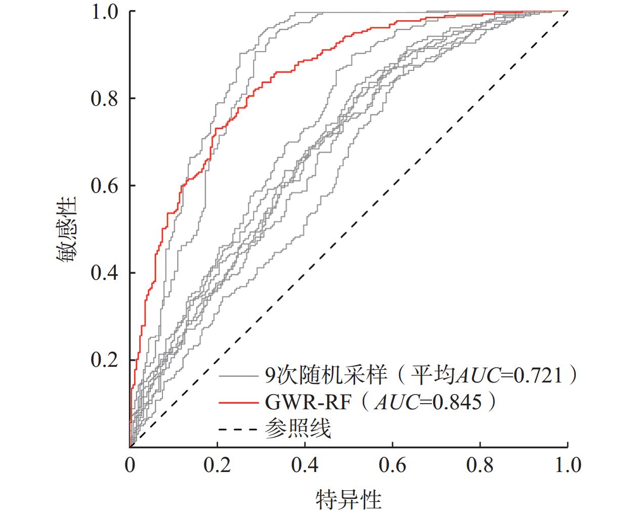
采用接受者操作特性曲线(Receiver Operating Characteristic Curve,ROC)和ROC 曲线下与坐标轴围成的面积(Area Under Curve,AUC)[29-32]评估模型拟合精度。模型拟合精度越好则AUC越接近1,0.7~0.9时表示较好。文中建立的证据权法模型的AUC为80.4%,拟合精度优异(图5)。
3.3 易发性评价结果
综合自然间断点分级和地质灾害分布,圈定了高易发区、中易发区和低易发区(表3、图6),其中高易发区188.55 km2(占研究区总面积的49.41%),中易发区152.21 km2(占研究区总面积的39.88%),89.9%和9.1%的地灾点落入高易发区和中易发区,显示易发性分区符合已发地质灾害分布,模型预测性能较好。
表 3 地质灾害易发性分区表Table 3. Form of geological hazard susceptibility zoning易发性
分区面积/
km2占总面积/
%编号 面积/
km2占大区/
面积%灾点数 灾点密度/
(个·km−2)地质灾害
高易发区(Ⅰ)188.55 49.41 Ⅰ1 152.32 80.79 64 0.41 Ⅰ2 17.93 9.51 9 0.50 Ⅰ3 16.11 8.54 8 0.94 Ⅰ4 2.19 1.16 1 0.46 地质灾害
中易发区(Ⅱ)152.21 39.88 Ⅱ1 1.30 0.85 − − Ⅱ2 18.82 12.36 2 0.11 Ⅱ3 15.03 9.87 1 0.07 Ⅱ4 12.92 8.49 − − Ⅱ5 18.51 12.16 2 0.11 Ⅱ6 9.12 5.99 − − Ⅱ7 44.66 29.34 − − Ⅱ8 12.34 8.11 1 0.08 Ⅱ9 11.73 7.71 − − Ⅱ10 7.78 5.11 − − 低易发区(Ⅲ) 47.40 12.42 Ⅲ1 47.40 100 1 0.02 结合地质环境因素特征分析西部高易发区(图6蓝色框范围内、图7)主要位于砂岩、泥岩和页岩岩组,断裂构造较密集,以山谷斜坡地貌为主,坡度15°~25°和>35°较陡峭斜坡范围成片发育且面积较广,主要公路建于本区山谷,裸地/稀疏植被和草地连片覆盖范围较大。预测圈定的高易发区的这些分布特征,与上文分析得到的地质灾害控制因素特征吻合,预测结果符合地质灾害空间分布特征。
4. 结论
(1)“因子面积百分比A”“地灾数百分比B”和“比率β”,以及各因素各分类地质灾害证据权重可以定量地分析各因素与地质灾害发生的相关性。
(2)圈定高易发区188.55 km2(占总面积的49.41%),中易发区152.21 km2(占总面积的39.88%),易发性分区图具有较好的等级区分度。
(3)通过证据权法绘制的地质灾害易发性图可以有效地预测该区地质灾害,模型拟合精度AUC=80.4%。89.9%和9.1%的地灾点落入高和中易发区,建模结果与实际地质灾害发育情况吻合度高,较好地揭示了研究区地质灾害易发性特征。
(4)证据权法在研究区这类云南高原低山丘陵区有效性高,方法理论清晰,较为成熟,由数据驱动,参数定义明确,易于一线工程师推广使用。同时,该方法权重的估计和模型预测性能受预测因子选择、因子数据空间分辨率、因子分级影响较大,具体工作中宜对这些问题进行深入研究和统计分析。建议通过对因子分级进行显著性测试实施优选,减小对权重的高估或低估,提高模型效能。
-
![]()
图 1 研究区位置及斜坡单元划分图
注:a为研究区位置;b为斜坡单元划分;c为斜坡单元形态示意图。
Figure 1. Location and slope unit division of the research area
![]()
图 4 地理加权空间分类图
Figure 4. Spatial classification map from geographically weighted results
表 1 滑坡易发性分区结果
Table 1 Results of landslide susceptibility zoning
模型 易发性等级 分区面积/km2 面积占比/% 分区滑坡数量/个 滑坡数量占比/% 滑坡密度/(个每100 km2) GWR-RF 极低易发 1704.02 13.85 7 0.65 0.41 低易发 1339.37 10.89 16 1.49 1.19 中易发 2231.27 18.13 66 6.15 2.96 高易发 3698.50 30.06 444 41.38 12.00 极高易发 3331.41 27.07 540 50.33 16.21 RS2 极低易发 1380.00 11.22 4 0.37 0.29 低易发 1344.82 10.93 17 1.58 1.26 中易发 2560.44 20.81 88 8.20 3.44 高易发 6959.27 56.56 935 87.14 13.44 极高易发 60.04 0.49 29 2.70 48.30 RS3 极低易发 1101.49 8.95 1 0.09 0.09 低易发 1219.89 9.91 13 1.21 1.07 中易发 1118.98 9.09 23 2.14 2.06 高易发 5489.84 44.62 522 48.65 9.51 极高易发 3374.37 27.42 514 47.90 15.23 RS7 极低易发 1987.32 16.15 8 0.75 0.40 低易发 1800.17 14.63 17 1.58 0.94 中易发 4941.03 40.16 234 21.81 4.74 高易发 3430.03 27.88 733 68.31 21.37 极高易发 146.07 1.19 81 7.55 55.45  下载: 导出CSV
表 2 模型效果对比
Table 2 Comparative analysis of model performance
模型 评价指标 精确率 召回率 F1分数 准确率 AUC RS1 0.763 0.798 0.744 0.846 0.873 RS2 0.649 0.693 0.825 0.801 0.730 RS3 0.749 0.785 0.669 0.839 0.847 RS4 0.619 0.643 0.661 0.779 0.698 RS5 0.595 0.626 0.670 0.778 0.663 RS6 0.608 0.637 0.671 0.780 0.684 RS7 0.581 0.623 0.679 0.781 0.624 RS8 0.613 0.644 0.682 0.782 0.679 RS9 0.619 0.649 0.785 0.783 0.695 $\overline {{\text{RS}}} $ 0.644±0.066 0.678±0.068 0.715±0.070 0.796±0.027 0.721±0.084 GWR-RF 0.700 0.735 0.773 0.814 0.845
下载: 导出CSV
-
[1] 牛朝阳,高欧阳,刘伟,等. 光学遥感图像滑坡检测研究进展[J]. 航天返回与遥感,2023,44(3):133 − 144. [NIU Chaoyang,GAO Ouyang,LIU Wei,et al. Research progress of landslide detection in optical remote sensing images[J]. Spacecraft Recovery & Remote Sensing,2023,44(3):133 − 144. (in Chinese with English abstract)] DOI: 10.3969/j.issn.1009-8518.2023.03.014 NIU Chaoyang, GAO Ouyang, LIU Wei, et al. Research progress of landslide detection in optical remote sensing images[J]. Spacecraft Recovery & Remote Sensing, 2023, 44(3): 133 − 144. (in Chinese with English abstract) DOI: 10.3969/j.issn.1009-8518.2023.03.014
[2] YALCIN A,REIS S,AYDINOGLU A C,et al. A GIS-based comparative study of frequency ratio,analytical hierarchy process,bivariate statistics and logistics regression methods for landslide susceptibility mapping in Trabzon,NE Turkey[J]. Catena,2011,85(3):274 − 287. DOI: 10.1016/j.catena.2011.01.014
[3] MERGHADI A,YUNUS A P,DOU Jie,et al. Machine learning methods for landslide susceptibility studies:A comparative overview of algorithm performance[J]. Earth-Science Reviews,2020,207:103225. DOI: 10.1016/j.earscirev.2020.103225
[4] 郭飞,赖鹏,黄发明,等. 基于知识图谱的滑坡易发性评价文献综述及研究进展[J]. 地球科学,2024,49(5):1584 − 1606. [GUO Fei,LAI Peng,HUANG Faming,et al. Literature review and research progress of landslide susceptibility mapping based on knowledge graph[J]. Earth Science,2024,49(5):1584 − 1606. (in Chinese with English abstract)] GUO Fei, LAI Peng, HUANG Faming, et al. Literature review and research progress of landslide susceptibility mapping based on knowledge graph[J]. Earth Science, 2024, 49(5): 1584 − 1606. (in Chinese with English abstract)
[5] 陈航, 刘惠军, 王韬, 等. 基于频率比-深度神经网络耦合模型的滑坡易发性评价——以盐源县为例[J]. 水文地质工程地质,2024,51(5):161 − 171. [CHEN Hang, LIU Huijun, WANG Tao, et al. Landslide susceptibility evaluation based on FR-DNN coupling model: A case study on Yanyuan County[J]. Hydrogeology & Engineering Geology,2024,51(5):161 − 171. (in Chinese with English abstract)] CHEN Hang, LIU Huijun, WANG Tao, et al. Landslide susceptibility evaluation based on FR-DNN coupling model: A case study on Yanyuan County[J]. Hydrogeology & Engineering Geology, 2024, 51(5): 161 − 171. (in Chinese with English abstract)
[6] 吕蓓茹,彭玲,李樵民. 顾及样本敏感性的滑坡易发性评价[J]. 测绘通报,2022(11):20 − 25. [LYU Beiru,PENG Ling,LI Qiaomin. Landslide susceptibility evaluation considering sample sensitivity[J]. Bulletin of Surveying and Mapping,2022(11):20 − 25. (in Chinese with English abstract)] LYU Beiru, PENG Ling, LI Qiaomin. Landslide susceptibility evaluation considering sample sensitivity[J]. Bulletin of Surveying and Mapping, 2022(11): 20 − 25. (in Chinese with English abstract)
[7] 黄发明,陈佳武,唐志鹏,等. 不同空间分辨率和训练测试集比例下的滑坡易发性预测不确定性[J]. 岩石力学与工程学报,2021,40(6):1155 − 1169. [HUANG Faming,CHEN Jiawu,TANG Zhipeng,et al. Uncertainties of landslide susceptibility prediction due to different spatial resolutions and different proportions of training and testing datasets[J]. Chinese Journal of Rock Mechanics and Engineering,2021,40(6):1155 − 1169. (in Chinese with English abstract)] HUANG Faming, CHEN Jiawu, TANG Zhipeng, et al. Uncertainties of landslide susceptibility prediction due to different spatial resolutions and different proportions of training and testing datasets[J]. Chinese Journal of Rock Mechanics and Engineering, 2021, 40(6): 1155 − 1169. (in Chinese with English abstract)
[8] 刘纪平,梁恩婕,徐胜华,等. 顾及样本优化选择的多核支持向量机滑坡灾害易发性分析评价[J]. 测绘学报,2022,51(10):2034 − 2045. [LIU Jiping,LIANG Enjie,XU Shenghua,et al. Multi-kernel support vector machine considering sample optimization selection for analysis and evaluation of landslide disaster susceptibility[J]. Acta Geodaetica et Cartographica Sinica,2022,51(10):2034 − 2045. (in Chinese with English abstract)] DOI: 10.11947/j.AGCS.2022.20220326 LIU Jiping, LIANG Enjie, XU Shenghua, et al. Multi-kernel support vector machine considering sample optimization selection for analysis and evaluation of landslide disaster susceptibility[J]. Acta Geodaetica et Cartographica Sinica, 2022, 51(10): 2034 − 2045. (in Chinese with English abstract) DOI: 10.11947/j.AGCS.2022.20220326
[9] 魏文豪,贾雨霏,盛逸凡,等. 基于Ⅰ、SVM、Ⅰ-SVM的滑坡灾害易发性评价模型研究[J]. 安全与环境工程,2023,30(3):136 − 144. [WEI Wenhao,JIA Yufei,SHENG Yifan,et al. Research on landslide susceptibility evaluation model based on Ⅰ,SVM and Ⅰ-SVM[J]. Safety and Environmental Engineering,2023,30(3):136 − 144. (in Chinese)] WEI Wenhao, JIA Yufei, SHENG Yifan, et al. Research on landslide susceptibility evaluation model based on Ⅰ, SVM and Ⅰ-SVM[J]. Safety and Environmental Engineering, 2023, 30(3): 136 − 144. (in Chinese)
[10] 何万才,赵俊三,林伊琳,等. 基于证据权和支持向量机模型的威信县滑坡易发性评价[J]. 科学技术与工程,2023,23(15):6350 − 6360. [HE Wancai,ZHAO Junsan,LIN Yilin,et al. Landslide susceptibility assessment in Weixin County based on evidence weight and support vector machine model[J]. Science Technology and Engineering,2023,23(15):6350 − 6360. (in Chinese with English abstract)] DOI: 10.12404/j.issn.1671-1815.2023.23.15.06350 HE Wancai, ZHAO Junsan, LIN Yilin, et al. Landslide susceptibility assessment in Weixin County based on evidence weight and support vector machine model[J]. Science Technology and Engineering, 2023, 23(15): 6350 − 6360. (in Chinese with English abstract) DOI: 10.12404/j.issn.1671-1815.2023.23.15.06350
[11] 黄发明,曾诗怡,姚池,等. 滑坡易发性预测建模的不确定性:不同“非滑坡样本”选择方式的影响[J]. 工程科学与技术,2023:1 − 14. [HUANG Faming,ZENG Shiyao,YAO Chi,et al. Uncertainties of landslide susceptibility prediction modeling:Influence of different selection methods of "non-landslide samples[J]. Advanced Engineering Sciences,2023,23(15):6350 − 6360. (in Chinese with English abstract)] HUANG Faming, ZENG Shiyao, YAO Chi, et al. Uncertainties of landslide susceptibility prediction modeling: Influence of different selection methods of "non-landslide samples[J]. Advanced Engineering Sciences, 2023, 23(15): 6350 − 6360. (in Chinese with English abstract)
[12] JACOBS L,KERVYN M,REICHENBACH P,et al. Regional susceptibility assessments with heterogeneous landslide information:Slope unit- vs. pixel-based approach[J]. Geomorphology,2020,356:107084. DOI: 10.1016/j.geomorph.2020.107084
[13] 张勇,温智,程英建. 四川巴中市滑坡灾害与降雨雨型关系探讨[J]. 水文地质工程地质,2020,47(2):178 − 182. [ZHANG Yong,WEN Zhi,CHENG Yingjian. A discussion of the relationship between landslide disaster and rainfall types in Bazhong of Sichuan[J]. Hydrogeology & Engineering Geology,2020,47(2):178 − 182. (in Chinese with English abstract)] ZHANG Yong, WEN Zhi, CHENG Yingjian. A discussion of the relationship between landslide disaster and rainfall types in Bazhong of Sichuan[J]. Hydrogeology & Engineering Geology, 2020, 47(2): 178 − 182. (in Chinese with English abstract)
[14] COMBER A,BRUNSDON C,CHARLTON M,et al. A route map for successful applications of geographically weighted regression[J]. Geographical Analysis,2023,55(1):155 − 178. DOI: 10.1111/gean.12316
[15] 卢宾宾,葛咏,秦昆,等. 地理加权回归分析技术综述[J]. 武汉大学学报(信息科学版),2020,45(9):1356 − 1366. [LU Binbin,GE Yong,QIN Kun,et al. A review on geographically weighted regression[J]. Geomatics and Information Science of Wuhan University,2020,45(9):1356 − 1366. (in Chinese with English abstract)] LU Binbin, GE Yong, QIN Kun, et al. A review on geographically weighted regression[J]. Geomatics and Information Science of Wuhan University, 2020, 45(9): 1356 − 1366. (in Chinese with English abstract)
[16] 于宪煜,熊十力. 基于空间多尺度分析的滑坡易发性评价——以三峡库区秭归-巴东段为例[J]. 大地测量与地球动力学,2020,40(2):187 − 192. [YU Xianyu,XIONG Shili. Landslide susceptibility assessment based on spatial multi-scale analysis:A case study of Zigui to Badong in the Three Gorges Reservoir area[J]. Journal of Geodesy and Geodynamics,2020,40(2):187 − 192. (in Chinese with English abstract)] YU Xianyu, XIONG Shili. Landslide susceptibility assessment based on spatial multi-scale analysis: A case study of Zigui to Badong in the Three Gorges Reservoir area[J]. Journal of Geodesy and Geodynamics, 2020, 40(2): 187 − 192. (in Chinese with English abstract)
[17] 方匡南,吴见彬,朱建平,等. 随机森林方法研究综述[J]. 统计与信息论坛,2011,26(3):32 − 38. [FANG Kuangnan,WU Jianbin,ZHU Jianping,et al. A review of technologies on random forests[J]. Statistics & Information Forum,2011,26(3):32 − 38. (in Chinese with English abstract)] FANG Kuangnan, WU Jianbin, ZHU Jianping, et al. A review of technologies on random forests[J]. Statistics & Information Forum, 2011, 26(3): 32 − 38. (in Chinese with English abstract)
[18] 于新洋,赵庚星,常春艳,等. 随机森林遥感信息提取研究进展及应用展望[J]. 遥感信息,2019,34(2):8 − 14. [YU Xinyang,ZHAO Gengxing,CHANG Chunyan,et al. Random forest classifier in remote sensing information extraction:A review of applications and future development[J]. Remote Sensing Information,2019,34(2):8 − 14. (in Chinese with English abstract)] YU Xinyang, ZHAO Gengxing, CHANG Chunyan, et al. Random forest classifier in remote sensing information extraction: A review of applications and future development[J]. Remote Sensing Information, 2019, 34(2): 8 − 14. (in Chinese with English abstract)
[19] 吴先谭,邓辉,张文江,等. 基于斜坡单元自动划分的滑坡易发性评价[J]. 山地学报,2022,40(4):542 − 556. [WU Xiantan,DENG Hui,ZHANG Wenjiang,et al. Evaluation of landslide susceptibility based on automatic slope unit division[J]. Mountain Research,2022,40(4):542 − 556. (in Chinese with English abstract)] WU Xiantan, DENG Hui, ZHANG Wenjiang, et al. Evaluation of landslide susceptibility based on automatic slope unit division[J]. Mountain Research, 2022, 40(4): 542 − 556. (in Chinese with English abstract)
[20] 李星,杨赛,李远耀,等. 面向区域滑坡易发性精细化评价的改进斜坡单元法[J]. 地质科技通报,2023,42(3):81 − 92. [LI Xing,YANG Sai,LI Yuanyao,et al. Improved slope unit method for fine evaluation of regional landslide susceptibility[J]. Bulletin of Geological Science and Technology,2023,42(3):81 − 92. (in Chinese with English abstract)] LI Xing, YANG Sai, LI Yuanyao, et al. Improved slope unit method for fine evaluation of regional landslide susceptibility[J]. Bulletin of Geological Science and Technology, 2023, 42(3): 81 − 92. (in Chinese with English abstract)
[21] 赵晓燕,谈树成,李永平. 基于斜坡单元与组合赋权法的东川区地质灾害危险性评价[J]. 云南大学学报(自然科学版),2021,43(2):299 − 305. [ZHAO Xiaoyan,TAN Shucheng,LI Yongping. Risk assessment of geological hazards in Dongchuan District based on the methods of slope unit and combination weighting[J]. Journal of Yunnan University (Natural Sciences Edition),2021,43(2):299 − 305. (in Chinese with English abstract)] ZHAO Xiaoyan, TAN Shucheng, LI Yongping. Risk assessment of geological hazards in Dongchuan District based on the methods of slope unit and combination weighting[J]. Journal of Yunnan University (Natural Sciences Edition), 2021, 43(2): 299 − 305. (in Chinese with English abstract)
[22] 刘传正,陈春利. 中国地质灾害成因分析[J]. 地质论评,2020,66(5):1334 − 1348. [LIU Chuanzheng,CHEN Chunli. Research on the origins of geological disasters in China[J]. Geological Review,2020,66(5):1334 − 1348. (in Chinese with English abstract)] LIU Chuanzheng, CHEN Chunli. Research on the origins of geological disasters in China[J]. Geological Review, 2020, 66(5): 1334 − 1348. (in Chinese with English abstract)
[23] HONG Haoyuan,POURGHASEMI H R,POURTAGHI Z S. Landslide susceptibility assessment in Lianhua County (China):A comparison between a random forest data mining technique and bivariate and multivariate statistical models[J]. Geomorphology,2016,259:105 − 118. DOI: 10.1016/j.geomorph.2016.02.012
[24] 蒋文学,李益敏,杨雪,等. 基于斜坡单元的怒江州滑坡易发性研究[J]. 水土保持学报,2023,37(5):160 − 167. [JIANG Wenxue,LI Yimin,YANG Xue,et al. Study on landslide susceptibility in Nujiang prefecture based on slope unit[J]. Journal of Soil and Water Conservation,2023,37(5):160 − 167. (in Chinese with English abstract)] JIANG Wenxue, LI Yimin, YANG Xue, et al. Study on landslide susceptibility in Nujiang prefecture based on slope unit[J]. Journal of Soil and Water Conservation, 2023, 37(5): 160 − 167. (in Chinese with English abstract)
[25] 郭衍昊,窦杰,向子林,等. 基于优化负样本采样策略的梯度提升决策树与随机森林的汶川同震滑坡易发性评价[J]. 地质科技通报,2024,43(3):251 − 265. [GUO Yanhao,DOU Jie,XIANG Zilin,et al. Susceptibility evaluation of Wenchuan coseismic landslides by gradient boosting decision tree and random forest based on optimal negative sample sampling strategies[J]. Bulletin of Geological Science and Technology,2024,43(3):251 − 265. (in Chinese with English abstract)] GUO Yanhao, DOU Jie, XIANG Zilin, et al. Susceptibility evaluation of Wenchuan coseismic landslides by gradient boosting decision tree and random forest based on optimal negative sample sampling strategies[J]. Bulletin of Geological Science and Technology, 2024, 43(3): 251 − 265. (in Chinese with English abstract)
[26] 阳清青,余秋兵,张廷斌,等. 基于GDIV模型的大渡河中游地区滑坡危险性评价与区划[J]. 中国地质灾害与防治学报,2023,34(5):130 − 140. [YANG Qingqing,YU Qiubing,ZHANG Tingbin,et al. Landslide hazard assessment in the middle reach area of the Dadu River based on the GDIV model[J]. The Chinese Journal of Geological Hazard and Control,2023,34(5):130 − 140. (in Chinese with English abstract)] YANG Qingqing, YU Qiubing, ZHANG Tingbin, et al. Landslide hazard assessment in the middle reach area of the Dadu River based on the GDIV model[J]. The Chinese Journal of Geological Hazard and Control, 2023, 34(5): 130 − 140. (in Chinese with English abstract)
[27] 于宪煜, 汤礼. 基于SMOTE-Tomek和CNN耦合的滑坡易发性评价模型及其应用——以三峡库区秭归—巴东段为例[J]. 中国地质灾害与防治学报,2024,35(3):141 − 151. [YU Xianyu, TANG Li. Landslide susceptibility mapping model based on a coupled model of SMOTE-Tomek and CNN and its application: A case study in the Zigui-Badong section of the Three Gorges Reservoir area[J]. The Chinese Journal of Geological Hazard and Control,2024,35(3):141 − 151. (in Chinese with English abstract)] YU Xianyu, TANG Li. Landslide susceptibility mapping model based on a coupled model of SMOTE-Tomek and CNN and its application: A case study in the Zigui-Badong section of the Three Gorges Reservoir area[J]. The Chinese Journal of Geological Hazard and Control, 2024, 35(3): 141 − 151. (in Chinese with English abstract)
[28] PETSCHKO H,BRENNING A,BELL R,et al. Assessing the quality of landslide susceptibility maps:case study Lower Austria[J]. Natural Hazards and Earth System Sciences,2014,14(1):95 − 118. DOI: 10.5194/nhess-14-95-2014
[29] 王惠,许月卿,刘超,等. 基于地理加权回归的生境质量对土地利用变化的响应 ——以河北省张家口市为例[J]. 北京大学学报(自然科学版),2019,55(3):509 − 518. [WANG Hui,XU Yueqing,LIU Chao,et al. Response of habitat quality to land use change based on geographical weighted regression[J]. Acta Scientiarum Naturalium Universitatis Pekinensis,2019,55(3):509 − 518. (in Chinese with English abstract)] WANG Hui, XU Yueqing, LIU Chao, et al. Response of habitat quality to land use change based on geographical weighted regression[J]. Acta Scientiarum Naturalium Universitatis Pekinensis, 2019, 55(3): 509 − 518. (in Chinese with English abstract)
[30] 陈强,朱慧敏,何溶,等. 基于地理加权回归模型评估土地利用对地表水质的影响[J]. 环境科学学报,2015,35(5):1571 − 1580. [CHEN Qiang,ZHU Huimin,HE Rong,et al. Evaluating the impacts of land use on surface water quality using geographically weighted regression[J]. Acta Scientiae Circumstantiae,2015,35(5):1571 − 1580. (in Chinese with English abstract)] CHEN Qiang, ZHU Huimin, HE Rong, et al. Evaluating the impacts of land use on surface water quality using geographically weighted regression[J]. Acta Scientiae Circumstantiae, 2015, 35(5): 1571 − 1580. (in Chinese with English abstract)
[31] SHIRZADI A,SOLAIMANI K,ROSHAN M H,et al. Uncertainties of prediction accuracy in shallow landslide modeling:Sample size and raster resolution[J]. Catena,2019,178:172 − 188. DOI: 10.1016/j.catena.2019.03.017
-
期刊类型引用(23)
1. 马明明,伍尚前,谢猛,童鹏,袁晓波. 决策树分类在铁路沿线桉树提取及滑坡隐患识别中的应用——以贵广高铁广西段为例. 中国地质灾害与防治学报. 2025(01): 37-45 .  本站查看
本站查看
2. 刘亚静,刘红健. 基于信息量-随机森林模型的地震带地质灾害易发性评价:以松潘-较场地震带为例. 科学技术与工程. 2024(01): 143-154 . 百度学术
3. 黄海,江思义,李海良,李春玲,吴秋菊. 岩溶地区危岩和岩质崩塌易发性评价研究——以广西贺州市平桂区为例. 成都理工大学学报(自然科学版). 2024(01): 137-151 . 百度学术
4. 刘玥,申玉松,李旭,张迪. 基于不同耦合模型的区域地质灾害易发性评价——以河南商城县为例. 中国地质调查. 2024(01): 83-92 . 百度学术
5. 高茂宁,魏冠军,雷传金,张沛. 顾及时序InSAR的海东市辖区滑坡敏感性评价. 地理空间信息. 2024(05): 97-101 . 百度学术
6. 石文君,王宇栋,解晋航,李章杰,梁形形. 基于多种模型对比的寻甸县地质灾害易发性分析. 矿产勘查. 2024(06): 1092-1102 . 百度学术
7. 寸得欣,令狐昌卫,马一奇,尹林虎,陈庆松,刘振南,涂春霖. 基于GIS和加权信息量模型的富源县地质灾害易发性评价. 科学技术与工程. 2024(18): 7563-7573 . 百度学术
8. 冯振,陈亮,王立朝,侯圣山,田怡帆,刘明学. 区域地质灾害易发性评价的证据权法原理与实践. 地质通报. 2024(07): 1255-1265 . 百度学术
9. 张宇,简季,郝利娜,杨鑫. 基于IV-MLP耦合模型的龙陵县滑坡易发性评价. 物探化探计算技术. 2024(05): 618-626 . 百度学术
10. 桂富羽,史正涛,喜文飞,付尧,郭峻杞. 基于证据权模型的滑坡灾害易发性评价研究——以普洱市为例. 城市勘测. 2024(05): 188-193+198 . 百度学术
11. 梁峰,江攀和. 基于IVM-CF耦合模型的贵定县滑坡地质灾害易发性评价. 水利水电技术(中英文). 2024(S2): 669-677 . 百度学术
12. 裴鹏程,黄帅,袁静,张智康. 走滑断层作用下上覆土层的变形破坏机理. 中国地质灾害与防治学报. 2024(06): 115-127 . 本站查看
13. 赖波,赵风顺,江金进,江山,江宁,李俊生. 基于AHP-信息量法的珠海市地质灾害风险评价. 华南地质. 2023(01): 147-156 . 百度学术
14. 阮征,周少伟,姚胜,田垚. 黄土高原腹地地质灾害致灾因素分析及易发性评价. 科技导报. 2023(10): 115-124 . 百度学术
15. 王伟中,李树兴,杨成,许涛,宋飞,曹小红,李浩然,王伟华. 基于GIS和证据权模型的山阳县地质灾害易发性评价. 新疆地质. 2023(02): 262-269 . 百度学术
16. 黄鑫,吴珍云,丁德建,李希星,石祖峰,祝民强,孙彬涵. 基于信息量-逻辑回归模型的江西省婺源县地质灾害易发性评价. 东华理工大学学报(自然科学版). 2023(03): 259-268 . 百度学术
17. 曾斌,吕权儒,寇磊,艾东,许汇源,袁晶晶. 基于Logistic回归和随机森林的清江流域长阳库岸段堆积层滑坡易发性评价. 中国地质灾害与防治学报. 2023(04): 105-113 . 本站查看
18. 胡杨,张紫昭,林世河. 基于证据权与逻辑回归耦合的新疆伊犁河谷地区滑坡易发性评价. 工程地质学报. 2023(04): 1350-1363 . 百度学术
19. 张潇远,苏巧梅,赵财胜,朱月琴,李凯新,范锦龙,白东升. 一种利用贝叶斯算法优化XGBoost的滑坡易发性评价方法. 测绘科学. 2023(06): 140-150 . 百度学术
20. 张华湘,孙乾征,樊善兴,杨子林. 滑坡易发性评价方法和精度比较——以贵州省大方县为例. 贵州地质. 2023(03): 302-309+295 . 百度学术
21. 龚芯磊,张斌,高金利,杨洪森. 基于斜坡单元尺度AHP-信息量模型的重点区域地质灾害风险评价——以贵州省紫云县中部重点区为例. 贵州地质. 2023(03): 310-320 . 百度学术
22. 谭燕,崔雨,金华丽,方龙建,葛鹏,付乐意. 基于信息量模型及层次分析法的镇江丹徒区滑坡崩塌地质灾害易发性评价. 昆明冶金高等专科学校学报. 2023(04): 7-15 . 百度学术
23. 董凯,王永卿,蒲秀勇,梁凯丽. 基于信息量法的广西南宁市武鸣区地质灾害易发性评价. 农业灾害研究. 2023(09): 300-303 . 百度学术
其他类型引用(8)


计量
- 文章访问数: 71
- HTML全文浏览量: 16
- PDF下载量: 24
- 被引次数: 31
 邮件订阅
邮件订阅 RSS
RSS