

Application of SBAS-InSAR technology to analyze the evolution characteristics and cause of ground subsidence in Sanhe City, Hebei Province
-
摘要:
2003—2016年,三河市地面沉降速率逐步加大,其中燕郊地区地面沉降最严重,已和北京通州沉降区连成一片,2016年之后三河市地面沉降灾害的发展变化趋势尚不明确。随着京津冀一体化发展、北京城市副中心建设等国家政策的出台,查明三河市地面沉降灾害的发展演化特征并分析成因对保障三河市的城市安全和可持续发展至关重要。文章采用SBAS-InSAR技术解译三河市2018—2020年地面沉降发展演化特征,同时分析了导致三河市地面沉降的几个诱发因素,总结沉降原因。通过本次研究,掌握了三河市地面沉降灾害的空间分布及演化特征:三河市地面沉降在空间上呈现西部严重,东部较缓,发育重点沉降区的总体特征;主要发育有2个重点沉降区,分别为含3个沉降漏斗的燕郊镇沉降区和含1个沉降漏斗的段甲岭镇沉降区,其中燕郊镇沉降区为三河市地面沉降最为严重的区域;2018—2020年,三河市地面沉降灾害总体呈现减缓趋势。同时通过对比分析,三河市地下水的严重超采、土层性质、城镇化发展及人口激增是三河市地面沉降灾害发生及发展的主要因素。研究成果将为该区域地面沉降灾害的防治提供参考。
Abstract:According to studies by relevant scholars, the ground subsidence rate in Sanhe City, Hebei, increased gradually from 2003 to 2016, with the most severe subsidence observed in the Yanjiao area , which has become contiguous with the subsidence area in Tongzhou, Beijing. However, the development trend of ground subsidence disasters in Sanhe City after 2016 remains unclear. With the implementation of national policies such as the integration of Beijing-Tianjin-Hebei region and the construction of Beijing’s sub-center, it is crucial to identify the development and evolution characteristics of land subsidence disasters in Sanhe City and analyze their causes to ensure the urban safety and sustainable development of Sanhe City. In this context, the authors used SBAS-InSAR technology to interpret the evolution characteristics of ground subsidence in Sanhe City from 2018 to 2020, and analyzed several inducing factors that led to land subsidence in Sanhe City, summarizing the main causes. Through this study, the spatial distribution and evolutionary characteristics of land subsidence disasters in Sanhe City were grasped: the western part of the city exhibits severe subsidence, while the eastern part is less affected, with a focus on the overall characteristics of key subsidence areas. Two main subsidence areas were identified, namely, the Yanjiao Town subsidence area with three subsidence funnels and the DuanJialing town subsidence area with one subsidence funnel, with the former being the most severely affected. From 2018 to 2020, the overall trend of ground subsidence disasters in Sanhe City showed a slowdown. Through comparative analysis, it was determined that severe overexploitation of groundwater, soil properties, urbanization development, and population growth are the main factors contributing to the occurrence and development of ground subsidence disasters in Sanhe City. The research results of this paper will provide reference for the prevention and control of ground subsidence disasters in the region.
-
0. 引言
地质灾害气象风险预警是基于气象降雨因素引发地质灾害的区域性预警,是通过分析孕育地质灾害的地质特征与引发地质灾害的降水特征建立模型算法,在地质灾害易发性基础上,结合前期过程降雨和未来预报降雨,对一定区域在未来一段时间内发生地质灾害的可能性及成灾风险进行预报预警。近20年的实践表明,地质灾害气象风险预警在防御地质灾害中发挥着“指挥棒”的作用,是地质灾害风险管控的行之有效的手段。
对降雨引发的地质灾害区域预警研究,广大学者开展了大量的研究和探索。美国地质调查局1969年完成了基于泥石流临界降雨强度预警系统的开发;1985年进行了区域内大暴雨与滑坡灾害的统计分析,建立了滑坡与降雨强度的临界降雨模型,并研发了早期的滑坡灾害预警系统[1];日本学者通过对流域实况降雨与地下水渗流场分析,研究确定泥石流发生的临界降雨阈值,并实现了自动预警;学者Flentje、Chowdhury、Crozier、Emmanuel Gabet、Aleotti、Enrico Gregori等也在实时预警方面做了大量的探索工作[2 − 3]。刘传正等[4 − 5]将区域预警理论原理分为隐式统计预警、显式统计预警和动力预警三大类,并针对显式统计预警模型提出了地质灾害区域“发育度”、“潜势度”、“危险度”、“风险度”和“危害度”等“五度”递进分析理论方法。刘艳辉等[6]在显式统计预警模型中采用确定系数方法实现了区域预警潜势度的计算,解决了地质灾害区域预警模型方法的难题,地质灾害气象预警工作逐步在全国山区省、市、县开展。以上研究成果多偏重于技术层面,对地质灾害防治管理体制机制方面的探索涉及较少。
在近20年的地质灾害气象风险预报预警工作实践中,因缺少统一的系统建设标准和成果发布规范,这种省、市、县各自建设的地质灾害气象预警系统经常会出现结果不统一、数据共享难、更新时效差、平台功能不完善等问题,导致同区域同时段出现不同预警等级和重复预警的现象,给基层应急响应和防灾处置工作带来一定困扰,对预警信息发布的严肃性和权威性造成不利影响[7 − 11]。2018年以来,浙江、四川、福建、云南等省份率先探索地质灾害省-市-县一体化预警平台建设,在数据资源高效共享、预警结果同台会商、预警信息统一发布等方面取得了较大进步,形成了不同模式的省-市-县一体化地质灾害风险预警体系。下面以浙江省为例介绍省-市-县一体化地质灾害风险预警系统建设。
1. 工作概况
1.1 浙江省地质背景及地质灾害概况
浙江省地处我国东南沿海,地貌类型多样,主要以中低山丘陵为主;地质构造复杂,以江山-绍兴深断裂带为界,横跨“扬子台地”(江南地层区)和“华南褶皱系”(华南地层区)两大Ⅰ级地质构造单元;降雨丰沛,梅汛期降雨持续时间长,台风降雨强度大。同时,人类工程活动强烈、人口密度大,容易引发地质灾害。浙江省地质灾害易发区占到全省陆域面积的73%(图1),地质灾害规模虽以小型为主,但时常造成较大的人员伤亡和经济损失。据统计,全省已发生突发性地质灾害灾情6343处,造成296人死亡、15人失踪、102人受伤,直接经济损失10.17亿元。截至2023年11月,全省现有地质灾害隐患点422处,地质灾害风险防范区16934处,威胁6.99万户22.2万人,威胁财产173.8亿元。
1.2 地质灾害预警工作概况
2003年浙江省自然资源厅与省气象局联合开展地质灾害预报预警工作,截至2023年,全省因地质灾害预警成功避险地质灾害532起,避免人员伤亡5564人,避免经济损失6252.5万元,取得了良好成效。为提升地质灾害预报预警精准度,2005年完成了市级1∶5万市级地质灾害预警系统,实现了省、市地质灾害分级预报预警;2007年为强化山区实况降雨对地质灾害的影响,将水利部门监测实况雨量纳入地质灾害预警系统,提升了地质灾害预报预警精度;2009年为有效防范局地强降雨引发地质灾害,研发了3 h短临预警系统;2013年针对预警对象研发了全国首个基于斜坡单元的地质灾害预警系统[12];2019年为进一步提升预警精度,采用均一单元升级了地质灾害预警系统[13];2020年,自然资源部在浙江实施地质灾害风险隐患“双控”试点,针对新调查的地质灾害风险防范区研发了以临界降雨为基础的1 h实时预警系统[14]。同时,将24 h每日预报、3 h短临预报和1 h的实时预警三种模式的地质灾害气象风险预报预警模型,并按照“省级预报到县、市级预报到乡、县级预警到村(点)”的工作原则,初步建成了省-市-县一体化地质灾害气象风险预报预警系统[15],并制定了《浙江省突发性地质灾害风险预报预警技术要求(试行)》,对全省地质灾害预报预警业务进行了规范。
2. 地质灾害风险预警一体化建设
2.1 预警工作内容
浙江省地质灾害气象风险预报预警时间尺度如图2所示,可分为趋势预测、等级预报和实时预警三类。
(1)趋势预测:根据气象部门阶段性降雨预测,按年度、季度、月度及重点时段(节假日和重要活动等)开展地质灾害风险趋势预测,研究确定本阶段是否可能存在地质灾害风险较高及以上区域、重点风险地段和风险点,以及相应时段,并提出本阶段地质灾害防范工作建议。
(2)风险预报:包括未来24 h地质灾害气象风险等级预报和未来3 h短临预报。根据气象部门未来24 h预报雨量和前期实况雨量,结合地质环境条件开展地质灾害风险区域预报,提醒预报区域防灾管理人员及时开展地质灾害防范工作;强降雨时段,结合实际工作需求,加密预报频次,根据气象部门未来3 h预报雨量和前期实况雨量,开展地质灾害气象风险3 h短临预报;台风暴雨时段开展48/72 h短期风险预报。风险预报为区域概率预报,预报层级最小到乡镇级。
(3)实时预警:通过研究设定地质灾害隐患点和风险防范区降雨阈值,结合周边雨量监测站监测的实时降雨开展地质灾害风险实时预警,并向地质灾害隐患点和风险防范区管理人员逐小时发布风险预警信息,指导基层开展地质灾害巡查和受威胁人员转移避险。实时预警是对区域概率预报的补充和矫正。
通过全面梳理省、市、县三级地质灾害风险预报预警业务工作需求,我省确定“省预报到县,市预报到乡,县预警到村(点)”的工作要求,省、市自然资源主管部门结合预报产品,以行政区划为单位,发布风险“五色图”,提醒各级部门依据工作职责,做好地质灾害防治工作;县级自然资源主管部门对地质灾害风险防范区和隐患点开展实时预警,实时发布风险预警信息,精准指导地质灾害影响人员转移避险,工作体系架构见图3。
![]() 图 3 预报预警工作结构框架图Figure 3. Structure framework diagram of forecast and early warning work
图 3 预报预警工作结构框架图Figure 3. Structure framework diagram of forecast and early warning work2.2 通用模型算法
通用模型是在全省地质灾害基础上统一研发的地质灾害气象风险预报预警模型,各市可直接调用,也可自行研发不同的预报预警模型。通用模型主要是通过区域地质灾害机理研究,确定地质灾害敏感因子和诱发因子,应用相关性原理建立地质灾害易发性评价指标体系,综合评价不同区域地质灾害易发程度,结合地质灾害与降雨量的关系分析,基于逻辑回归的概率预报方法,构建地质灾害气象风险预报预警模型,包含省市3 h短时预报、24 h常规预报、48/72 h趋势预测模型,开展区域地质灾害风险等级预报。县级实时预警模型主要面向地质灾害风险防范区和隐患点开展,根据降雨强度-历时(I-D曲线)确定临界降雨阈值,利用实时降雨与临界降雨阈值判别矩阵开展实时预警工作。
2.2.1 省市等级预报模型方法
省级预报模型主要采用主成分逻辑回归方法(图4),以地质灾害赋存环境条件均一的不规则单元为预报对象,对已发生地质灾害影响因子进行主成分分析,最终确定坡度、坡向、高程、地层岩性、断裂构造、工程地质岩组,土地利用及植被类型共8个因子作为地质灾害敏感因子。其中省级预报模型以全省山地丘陵区为地质灾害预报预警范围构建32.5万余评价单元,对预警单元进行地质灾害危险性指标(G)进行计算,通过危险度与降雨条件(降水指数)的相关及回归分析,确立预警指数数学表达式(式1)。
![]() 图 4 地质灾害气象风险预报模型方法Figure 4. Methodology of geological hazard meteorological risk prediction model
图 4 地质灾害气象风险预报模型方法Figure 4. Methodology of geological hazard meteorological risk prediction model$$ T={k}_{0}G+{k}_{1}({R}_{{\mathrm{a}}}+{R}_{{\mathrm{f}}})/{R}_{0}+e $$ (1) 式中:
$ T $ ——预警指数;${G} $ ——地质灾害危险性指标;$ {R}_{{\mathrm{a}}} $ ——前期有效降雨;$ {R}_{{\mathrm{f}}} $ ——预报降雨;$ {R}_{0} $ ——降雨区划;$ {k}_{0} $ 、$ {k}_{1} $ ——回归系数;e——修正值。
经过统计分析,浙江省大部分地质灾害均在强降雨当天发生,而地质灾害发生前3 d有降雨的占83.9%,前7 d累计降雨与地质灾害发生数相关程度非常高[7]。根据实际降雨与地质灾害发生情况复盘分析,短临预报通常考虑前24 h有效雨量,每日预报和短期预报考虑前7日累计有效雨量符合浙江省地质灾害发生与降雨强度规律[12 − 13]。
市级预报模型除宁波采用斜坡单元外,其余均采用200~500 m精度的网格单元,因东西部地质条件差异和降雨类型(台风暴雨和梅雨)不同,采用的地质灾害影响因子和前期降雨稍有不同,均采用逻辑回归的方法建立市级预报模型。
2.2.2 县级实时预警模型方法
预警模型主要采用降雨强度-历时(I-D曲线)的临界降雨阈值方法[14 − 16]。浙江省以县级行政区划为单元,统计分析历史发生的地质灾害降雨强度(I)和降雨历时(D)的关系,在对数坐标下,以数据分布(式2)的下限作为该县(市、区)的降雨阈值曲线(I-D曲线),并根据该曲线,提取不同历时(1 h、3 h、6 h、12 h、24 h)的黄、橙、红临界降雨阈值来实施地质灾害实时预警(图5)。目前,依托乡镇地质灾害风险调查项目,根据地质灾害体的破坏和变形情况、受灾体的风险承受差异等指标,逐步实现更为精细的“一坡一阈值”风险动态调整机制。
![]()
$$ R(H)=a{H}^{b} $$ (2) 式中:
$ R(H) $ ——降雨强度;$ H $ ——降雨时长;$ a $ ——比例系数;$ b $ ——幂指数。2.3 预警系统建设
根据地质灾害气象风险预警业务需求,采用节点建设模式,基于云计算技术研发了省市县一体化预报预警平台,平台由数据中心、数据中台及应用场景组成。数据中心主要负责数据采集、存储和管理等,包含数据仓、模型仓、功能仓和节点仓,每个节点仓保存各自的业务库、雨量库和成果库;数据中台主要负责数据调用、治理和共享,为全省预报预警一体化业务提供数据节点管理、功能调用、综合展示、运维监控和共享管理等功能;应用场景包括等级预报子系统、实时预警子系统、其他预警子系统和会商平台[15]。平台基础设施如服务器、网络及安全防护等资源由省级统一建设,市县级应用场景按照标准格式,调用省数据中心数据,结合当地气象、水利部门降雨数据进行地质灾害等级预报和实时预警,并将预警响应数据反馈数据中心,形成闭环管理。系统实现了跨部门多层级业务融合和数据共性支撑全省复用,同时,预报预警产品通过数据服务接口,实时为地质灾害防治业务场景、防汛防台在线等提供预警成果共享服务。
2.3.1 等级预报子系统
等级预报子系统主要在建设省、市两级,是开展地质灾害区域风险分析的专业系统,包含数据获取处理、模型分析计算、人工会商干预、预报产品制作和预报产品发布等功能。各级子系统通过专线将各级气象降雨预报数据导入数据中心,通过模型计算形成初级预报结果,上传会商中心进行全省会商研判,各市根据研判结果分别制作市、县预报产品进行发布,省级部门对各市产品进行综合,形成地质灾害风险等级预报“五色图”进行发布。同时,省部门根据气象3 h降雨预报数据实施自动化短临预警提醒。
2.3.2 实时预警子系统
实时预警子系统主要建设在县级,是针对地质灾害隐患点、风险防范区和重点乡村进行实时自动化预警,每小时发布风险预警信息。主要功能包括数据获取处理、预警分析研判和预警结果发布等。县级实时预警系统将地质灾害风险防范区或隐患点关联周边气象和水文部门雨量监测站,利用监测降雨量与1 h、3 h、6 h、12 h、24 h的黄、橙、红临界降雨阈值进行对比研判,采用不同历时的最高预警等级作为当前地质灾害风险防范区或隐患点的预警级别,并逐小时更新。
2.3.3 任务闭环和监管系统
为保证地质灾害风险预报预警信息的任务闭环和可视化监管,一体化预警平台研发了风险防控驾驶舱和移动应用终端“地灾智防”APP。通过移动终端,实时查询地质灾害等级预报、实时预警、专业监测预警等预警信息,实现防灾指令的实时贯通和防灾数据的及时汇集;通过驾驶舱大屏,各级自然资源主管部门可以查看台风降雨、等级预报、实时预警、值班值守、巡查排查、驻县进乡、灾险情处置、防治工作等信息,切实提升浙江省地质灾害防治指挥决策的时效性和科学性。
2.3.4 预警闭环管控机制
“省级预报到县、市级预报到乡、县级预警到村(点)”工作体系是浙江省地质灾害气象风险预报预警一体化工作机制的重要内容之一。省级通过一体化平台省级节点,开展3 h、24 h等多时段地质灾害风险等级预报,发布范围覆盖省级有关部门和市、县自然资源主管部门;市级地质灾害风险等级预报成果范围覆盖市级有关部门和县级自然资源主管部门和乡镇(街道);县级通过气象、水利部门的实况降雨数据,结合风险降雨阈值,针对地质灾害隐患点、风险防范区和重点乡村等开展实时预警,发布范围覆盖县级有关部门和乡(镇街道)村(社区)责任人和群测群防员(图6)。
![]() 图 6 一体化地质灾害风险预报预警系统框架图Figure 6. Framework diagram of integrated geological hazard risk forecast and early warning system
图 6 一体化地质灾害风险预报预警系统框架图Figure 6. Framework diagram of integrated geological hazard risk forecast and early warning system“有预警就有响应,有响应务必闭环”是一体化工作机制的另一重要内容,根据省、市、县三级在不同防御阶段的地质灾害风险管控要求,围绕地质灾害风险预报预警结果,移动终端发布预报预警信息,派发巡查处置任务,并回流基层地质灾害防治工作反馈情况,实现地质灾害风险预报预警响应的闭环管控。通过驾驶舱大屏,实现地质灾害风险信息和防治业务信息的可视化展示,消息和任务的全生命周期监控,配合“叫应叫醒”工作机制,保证信息的贯通,落实闭环管理。
3. 典型预警案例
受2023年5号台风“杜苏芮”影响,温州南部地区遭受持续强降雨。2023年7月26日18时,省级预警系统对温州市平阳县发布未来24 h地质灾害气象风险橙色预警,温州市预警系统对平阳县顺溪镇发布未来24 h地质灾害气象风险橙色预警。27日8时省、市预警级别均升级为红色预警(图7),值班人员第一时间电话叫应当地政府主要领导。顺溪镇人民政府立即组织开展隐患点和风险防范区人员转移工作,11时将顺溪镇下东村风险防范区(编号330326FF0263)受威胁的5人提前转移至避灾场所。27日13时县级实时预警系统(基于临界降水阈值模型)对该处风险防范区发布黄色预警,并生成巡查任务,群测群防员立即开展巡查,并通过“地灾智防”APP反馈巡查和人员转移情况。14时省级预警系统对平阳县再次加密发布未来3 h短临红色预警,15时该处专业监测设备也发出红色报警,16时该风险防范区发生滑坡,体积约300 m3。滑坡造成坡脚房屋墙体和窗户局部损毁和屋内泥水淤积(图8)。由于预警及时精准,人员提前撤离,成功避免1户5人伤亡。本起案例是基于省-市-县一体化预警工作体系,逐级逐步精准发布预警信息、有效落实闭环管控、成功避免人员伤亡的典型案例。
![]() 图 7 地质灾害风险预警综合展示图Figure 7. Comprehensive display of geological disaster risk early warning
图 7 地质灾害风险预警综合展示图Figure 7. Comprehensive display of geological disaster risk early warning![]() 图 8 温州市平阳县顺溪镇下东村滑坡Figure 8. Landslide at Xiadong Village, Shunxi Town, Pingyang County, Wenzhou City
图 8 温州市平阳县顺溪镇下东村滑坡Figure 8. Landslide at Xiadong Village, Shunxi Town, Pingyang County, Wenzhou City4. 结论
(1)浙江省通过构建“省级预报到县、市级预报到乡、县级预警到村(到点)”预报预警一体化工作体系,依托“地灾智防”APP等数字化手段,加强了预报预警与预警响应联动,建立预警响应闭环工作机制,实现了地质灾害气象风险预警响应闭环管理。
(2)浙江省通过开展地质灾害气象风险预警一体化建设,在模型构建、系统建设、数据共享和闭环管控机制建设等方面形成了一套较为完整的技术和管理体系,为其他省市开展预警一体化建设提供了较为成熟的应用示范。
(3)浙江省预报预警一体化系统自上线以来,运行效果良好,工作成效显著,有效支撑了全省地质灾害防治工作。但由于预报降雨数据更新和实况降雨数据校正的滞后性,导致地质灾害风险预警结果实时性不足,在与气象、水利部门数据协同机制方面仍需进一步加强。
-
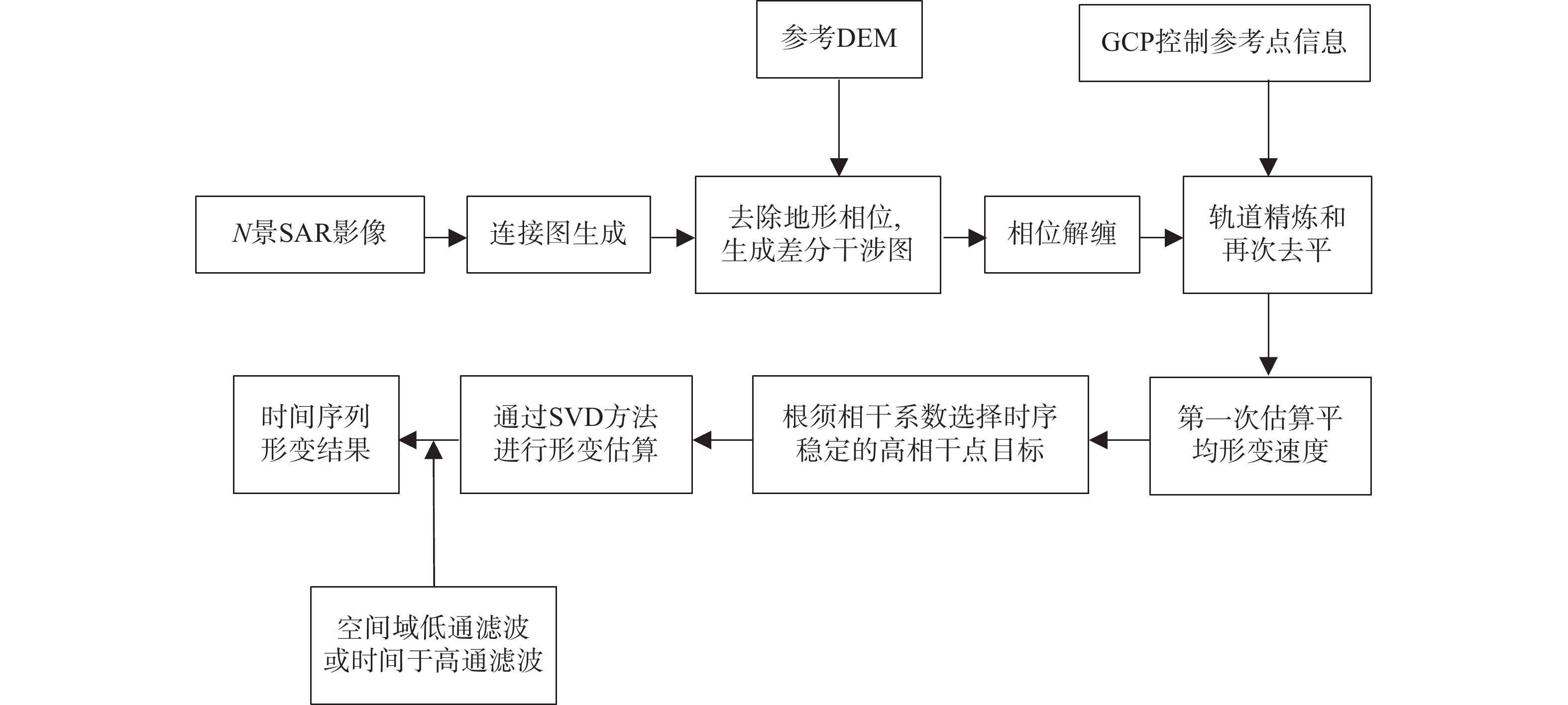
![]()
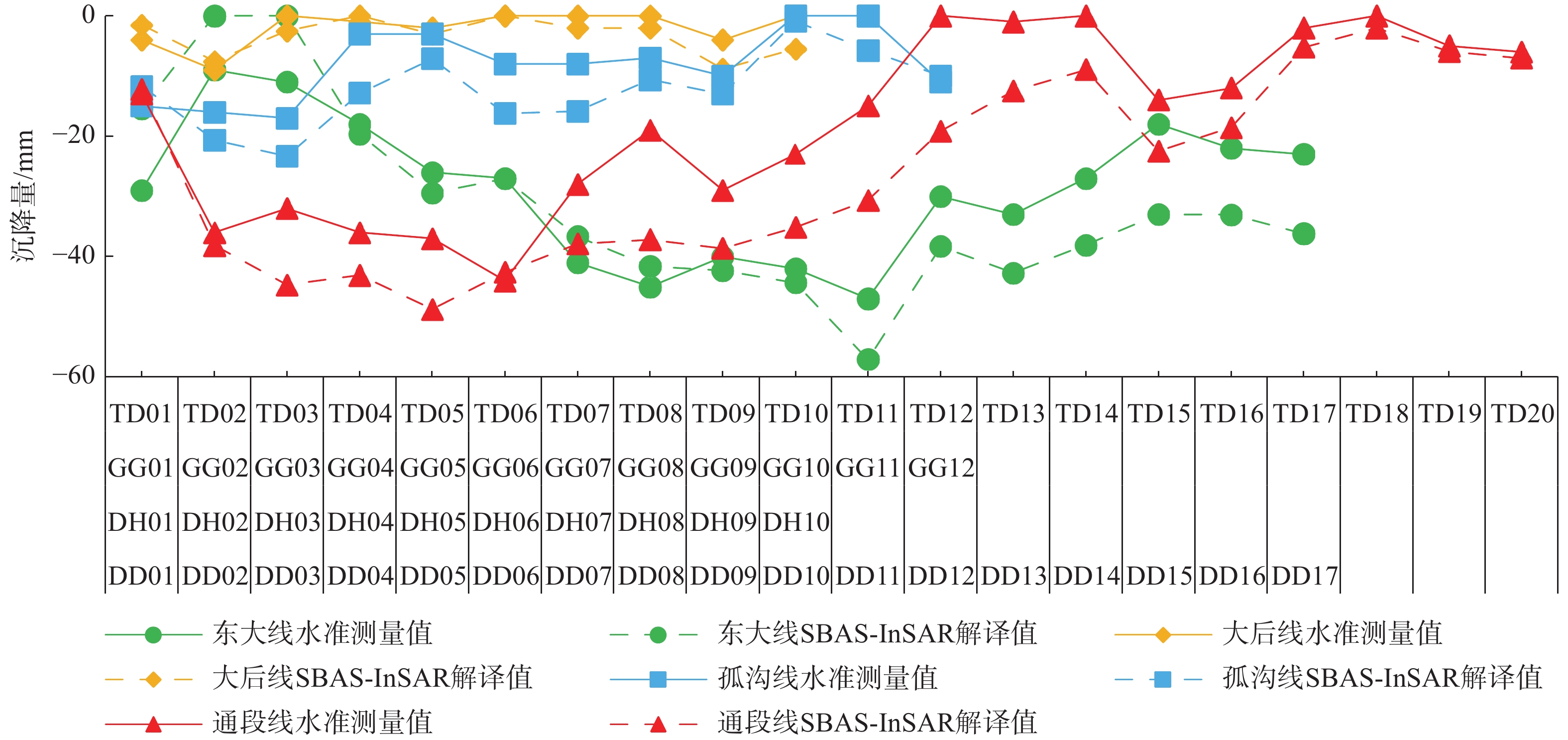
图 3 水准测量值与SBAS-InSAR解译值对比图
Figure 3. Comparison between leveling measurement values and SBAS-InSAR interpreted values
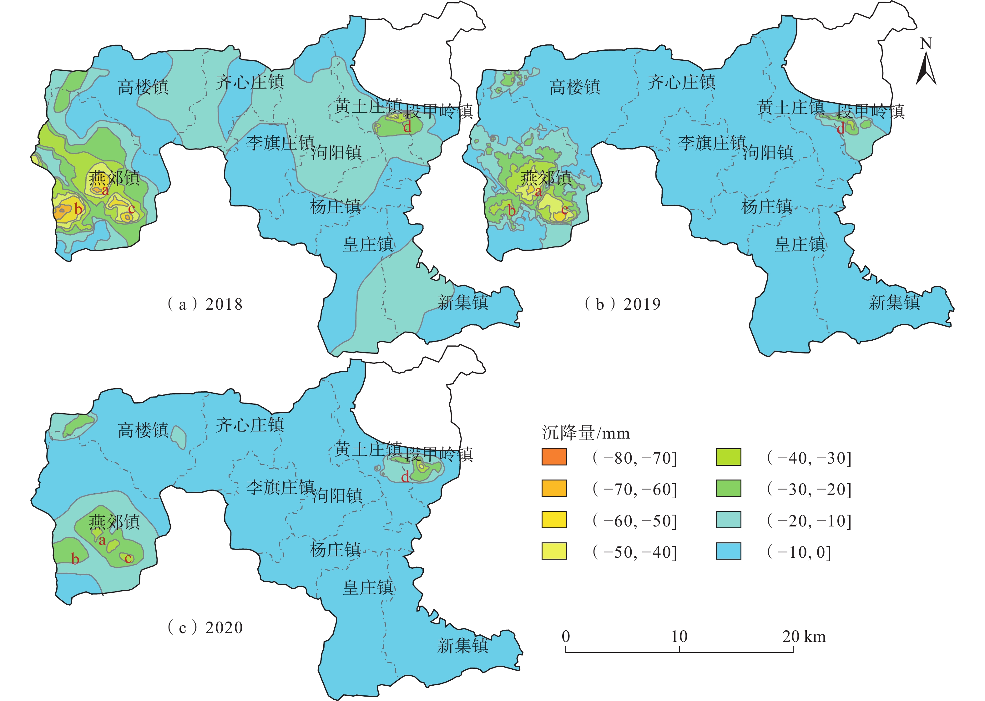
![]()
图 4 2018、2019、2020年三河市地面沉降时间序列演化特征
Figure 4. Time-series evolution characteristics of land subsidence in Sanhe City for the years 2018, 2019, and 2020
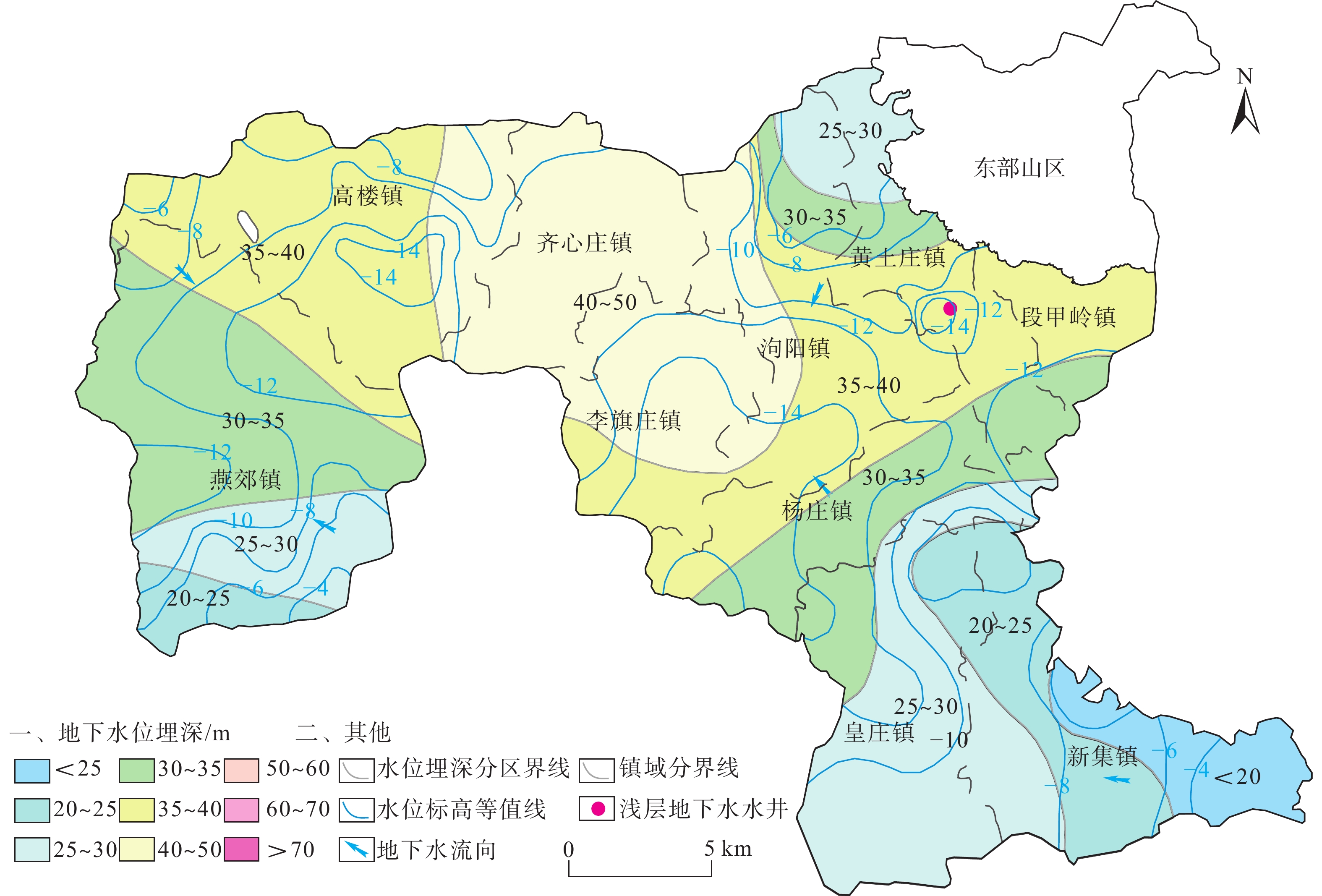
![]()
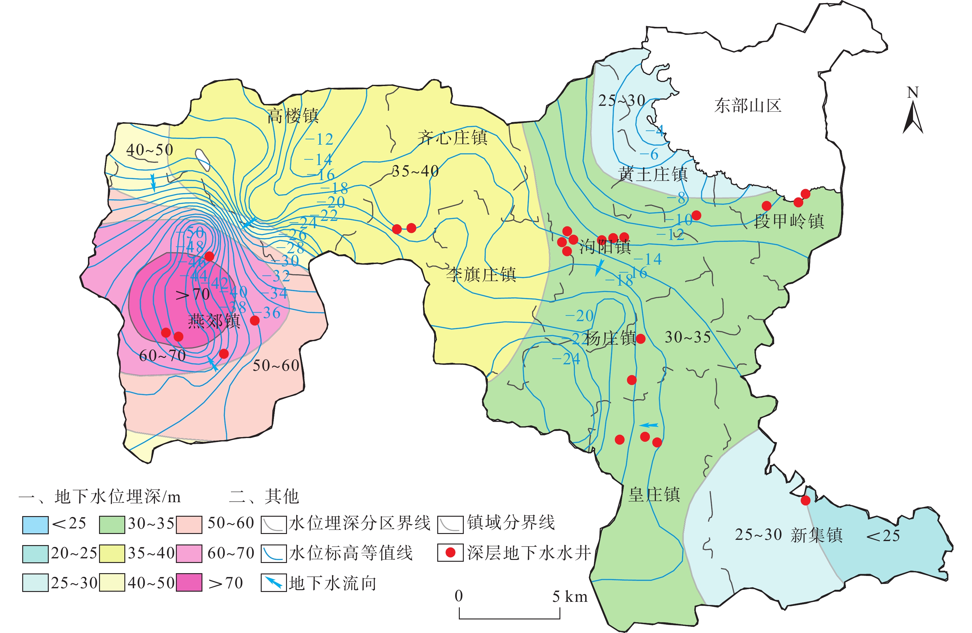
图 5 2020年8月三河市浅层含水层地下水水位等值线和水位埋深图
Figure 5. Groundwater level contour and buried depth in shallow aquifers in Sanhe City, August 2020
![]()
图 6 2020年8月三河市深层含水层地下水水位等值线和水位埋深图
Figure 6. Groundwater level contour and buried depth map of deep aquifer in Sanhe City, August 2020
![]()
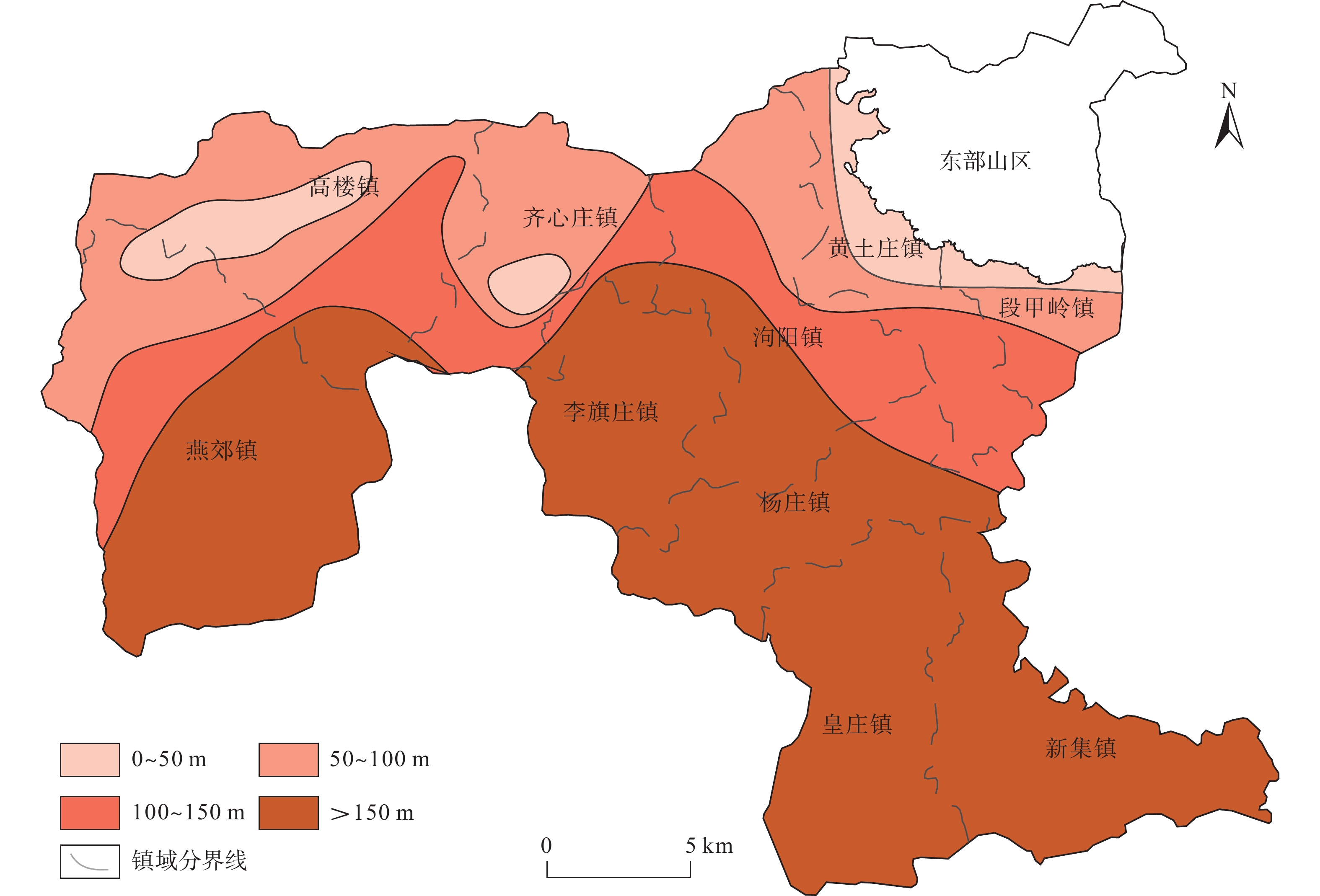
图 7 三河市平原区黏土层总厚度分区图
Figure 7. Zoning map of total thickness of clay layer in the plain area of Sanhe City
![]()
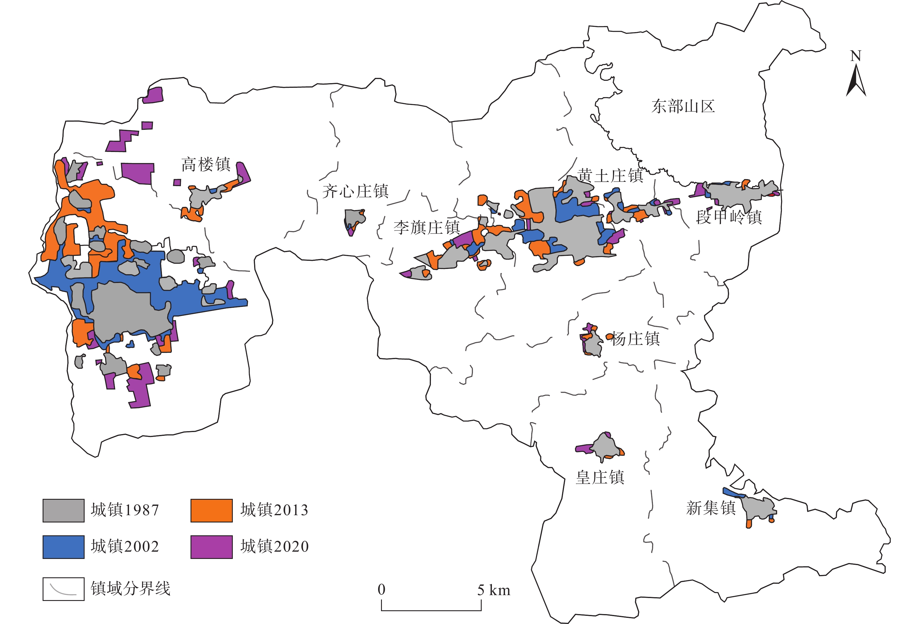
图 8 1987—2020年三河市城镇扩张进程图
Figure 8. Urban expansion process map of in Sanhe City from 1987 to 2020
表 1 2016年三河市各乡镇地下水开发利用简表
Table 1 Summary of groundwater development and utilization invarious townships of Sanhe City in the year 2016
乡镇 生活用水 农业用水 工业用水 浅层开采量 深层开采量 基岩开采量 总开采量 深层 基岩 浅层 深层 基岩 燕郊镇 5123.94 0 480.06 1070.57 0 480.06 6194.51 0 6674.57 泃阳镇 513.12 0 961.84 266.94 0 961.84 780.06 0 1741.9 高楼镇 176.48 2945.04 914.79 0 0 914.79 176.48 2945.04 4036.31 齐心庄镇 120.67 18.03 688.09 0 330.46 688.09 120.67 348.49 1157.25 段甲岭镇 63.8 56.11 448.46 0 0 448.46 63.8 56.11 568.37 李旗庄镇 138.7 0 487.69 0 0 487.69 138.7 0 626.39 黄土庄镇 247.11 0 1072.13 0 0 1072.13 247.11 0 1319.24 杨庄镇 202.94 0 696.02 0 0 696.02 202.94 0 898.96 皇庄镇 268.22 0 964.47 0 0 964.47 268.22 0 1232.69 新集镇 328.83 0 1098.45 0 0 1098.45 328.83 0 1427.28 合计 10202.99 7812 1667.97 7812 8521.32 3349.64 19683 注:单位为104 m3。  下载: 导出CSV
-
[1] 张拴宏,纪占胜. 合成孔径雷达干涉测量(InSAR)在地面形变监测中的应用[J]. 中国地质灾害与防治学报,2004,15(1):112 − 117. [ZHANG Shuanhong,JI Zhansheng. A review on the application of interferometric synthetic aperture radar on surface deformation monitoring[J]. The Chinese Journal of Geological Hazard and Control,2004,15(1):112 − 117. (in Chinese with English abstract)] DOI: 10.3969/j.issn.1003-8035.2004.01.024 ZHANG Shuanhong, JI Zhansheng. A review on the application of interferometric synthetic aperture radar on surface deformation monitoring[J]. The Chinese Journal of Geological Hazard and Control, 2004, 15(1): 112 − 117. (in Chinese with English abstract) DOI: 10.3969/j.issn.1003-8035.2004.01.024
[2] 许文斌,李志伟,丁晓利,等. 利用InSAR短基线技术估计洛杉矶地区的地表时序形变和含水层参数[J]. 地球物理学报,2012,55(2):452 − 461. [XU Wenbin,LI Zhiwei,DING Xiaoli,et al. Application of small baseline subsets D-InSAR technology to estimate the time series land deformation and aquifer storage coefficients of LosAngeles area[J]. Chinese Journal of Geophysics,2012,55(2):452 − 461. (in Chinese with English abstract)] DOI: 10.6038/j.issn.0001-5733.2012.02.009 XU Wenbin, LI Zhiwei, DING Xiaoli, et al. Application of small baseline subsets D-InSAR technology to estimate the time series land deformation and aquifer storage coefficients of LosAngeles area[J]. Chinese Journal of Geophysics, 2012, 55(2): 452 − 461. (in Chinese with English abstract) DOI: 10.6038/j.issn.0001-5733.2012.02.009
[3] GABRIEL A K,GOLDSTEIN R M,ZEBKER H A. Mapping small elevation changes over large areas:Differential radar interferometry[J]. Journal of Geophysical Research:Solid Earth,1989,94(B7):9183 − 9191. DOI: 10.1029/JB094iB07p09183
[4] FERRETTI A,PRATI C,ROCCA F. Permanent scatterers in SAR interferometry[J]. IEEE Transactions on Geoscience and Remote Sensing,2001,39(1):8 − 20. DOI: 10.1109/36.898661
[5] BERARDINO P,FORNARO G,LANARI R,et al. A new algorithm for surface deformation monitoring based on small baseline differential SAR interferograms[J]. IEEE Transactions on Geoscience and Remote Sensing,2002,40(11):2375 − 2383. DOI: 10.1109/TGRS.2002.803792
[6] 罗三明,杜凯夫,畅柳,等. 基于PS-InSAR方法反演北京地区地表沉降速率[J]. 大地测量与地球动力学,2014,34(1):43 − 46. [LUO Sanming,DU Kaifu,CHANG Liu,et al. Ground subsidence rates of Beijing area inversed by PS-InSAR analysis[J]. Journal of Geodesy and Geodynamics,2014,34(1):43 − 46. (in Chinese with English abstract)] DOI: 10.14075/j.jgg.2014.01.024 LUO Sanming, DU Kaifu, CHANG Liu, et al. Ground subsidence rates of Beijing area inversed by PS-InSAR analysis[J]. Journal of Geodesy and Geodynamics, 2014, 34(1): 43 − 46. (in Chinese with English abstract) DOI: 10.14075/j.jgg.2014.01.024
[7] 郭海朋,白晋斌,张有全,等. 华北平原典型地段地面沉降演化特征与机理研究[J]. 中国地质,2017,44(6):1115 − 1127. [GUO Haipeng,BAI Jinbin,ZHANG Youquan,et al. The evolution characteristics and mechanism of the land subsidence in typical areas of the north China Plain[J]. Geology in China,2017,44(6):1115 − 1127. (in Chinese with English abstract)] DOI: 10.12029/gc20170606 GUO Haipeng, BAI Jinbin, ZHANG Youquan, et al. The evolution characteristics and mechanism of the land subsidence in typical areas of the north China Plain[J]. Geology in China, 2017, 44(6): 1115 − 1127. (in Chinese with English abstract) DOI: 10.12029/gc20170606
[8] 周旭,许才军,温扬茂. 利用时序InSAR技术分析北京及河北廊坊地面沉降[J]. 测绘科学,2017,42(7):89 − 93. [ZHOU Xu,XU Caijun,WEN Yangmao. Land subsidence monitoring of Beijing and Langfang of Hebei Prouince by time series InSAR[J]. Science of Surveying and Mapping,2017,42(7):89 − 93. (in Chinese with English abstract)] DOI: 10.16251/j.cnki.1009-2307.2017.07.015 ZHOU Xu, XU Caijun, WEN Yangmao. Land subsidence monitoring of Beijing and Langfang of Hebei Prouince by time series InSAR[J]. Science of Surveying and Mapping, 2017, 42(7): 89 − 93. (in Chinese with English abstract) DOI: 10.16251/j.cnki.1009-2307.2017.07.015
[9] 李海君,张耀文,杨月巧,等. 廊坊北三县地区地面沉降时空分布特征与成因分析[J]. 科学技术与工程,2018,18(11):23 − 30. [LI Haijun,ZHANG Yaowen,YANG Yueqiao,et al. Spatial-temporal distribution characteristics and causation analysis of land subsidence in three northern counties area of Langfang[J]. Science Technology and Engineering,2018,18(11):23 − 30. (in Chinese with English abstract)] DOI: 10.3969/j.issn.1671-1815.2018.11.003 LI Haijun, ZHANG Yaowen, YANG Yueqiao, et al. Spatial-temporal distribution characteristics and causation analysis of land subsidence in three northern counties area of Langfang[J]. Science Technology and Engineering, 2018, 18(11): 23 − 30. (in Chinese with English abstract) DOI: 10.3969/j.issn.1671-1815.2018.11.003
[10] 李广宇,张瑞,刘国祥,等. Sentinel-1A TS-DInSAR京津冀地区沉降监测与分析[J]. 遥感学报,2018,22(4):633 − 646. [LI Guangyu,ZHANG Rui,LIU Guoxiang,et al. Land subsidence detection and analysis over Beijing-Tianjin-Hebei area based on Sentinel-1A TS-DInSAR[J]. Journal of Remote Sensing,2018,22(4):633 − 646. (in Chinese with English abstract)] LI Guangyu, ZHANG Rui, LIU Guoxiang, et al. Land subsidence detection and analysis over Beijing-Tianjin-Hebei area based on Sentinel-1A TS-DInSAR[J]. Journal of Remote Sensing, 2018, 22(4): 633 − 646. (in Chinese with English abstract)
[11] 刘毅. 地面沉降研究的新进展与面临的新问题[J]. 地学前缘,2001,8(2):273 − 278. [LIU Yi. Land subsidence research approaches and advent problems[J]. Earth Science Frontiers,2001,8(2):273 − 278. (in Chinese with English abstract)] DOI: 10.3321/j.issn:1005-2321.2001.02.009 LIU Yi. Land subsidence research approaches and advent problems[J]. Earth Science Frontiers, 2001, 8(2): 273 − 278. (in Chinese with English abstract) DOI: 10.3321/j.issn:1005-2321.2001.02.009
[12] 葛伟丽,李元杰,张春明,等. 基于InSAR技术的内蒙古巴彦淖尔市地面沉降演化特征及成因分析[J]. 水文地质工程地质,2022,49(4):198 − 206. [GE Weili, LI Yuanjie, ZHANG Chunming, et al. An attribution analysis of land subsidence features in the city of Bayannur in Inner Mongolia based on InSAR[J]. Hydrogeology & Engineering Geology,2022,49(4):198 − 206. (in Chinese with English abstract)] GE Weili, LI Yuanjie, ZHANG Chunming, et al. An attribution analysis of land subsidence features in the city of Bayannur in Inner Mongolia based on InSAR[J]. Hydrogeology & Engineering Geology, 2022, 49(4): 198 − 206. (in Chinese with English abstract)
[13] 何庆成,刘文波,李志明. 华北平原地面沉降调查与监测[J]. 高校地质学报,2006,12(2):195 − 209. [HE Qingcheng,LIU Wenbo,LI Zhiming. Investigation and monitoring of land subsidence in north China Plain[J]. Geological Journal of China Universities,2006,12(2):195 − 209. (in Chinese)] DOI: 10.3969/j.issn.1006-7493.2006.02.006 HE Qingcheng, LIU Wenbo, LI Zhiming. Investigation and monitoring of land subsidence in north China Plain[J]. Geological Journal of China Universities, 2006, 12(2): 195 − 209. (in Chinese) DOI: 10.3969/j.issn.1006-7493.2006.02.006
[14] 侯安业,张景发,刘斌,等. PS-InSAR与SBAS-InSAR监测地表沉降的比较研究[J]. 大地测量与地球动力学,2012,32(4):125 − 128. [HOU Anye,ZHANG Jingfa,LIU Bin,et al. Comparative study on monitoring surface subsidence with PS-InSAR and SBAS-InSAR[J]. Journal of Geodesy and Geodynamics,2012,32(4):125 − 128. (in Chinese with English abstract)] DOI: 10.3969/j.issn.1671-5942.2012.04.029 HOU Anye, ZHANG Jingfa, LIU Bin, et al. Comparative study on monitoring surface subsidence with PS-InSAR and SBAS-InSAR[J]. Journal of Geodesy and Geodynamics, 2012, 32(4): 125 − 128. (in Chinese with English abstract) DOI: 10.3969/j.issn.1671-5942.2012.04.029
[15] MASSONNET D,HOLZER T,VADON H. Land subsidence caused by the East Mesa Geothermal Field,California,observed using SAR interferometry[J]. Geophysical Research Letters,1997,24(8):901 − 904. DOI: 10.1029/97GL00817
[16] 张凯翔,张占荣,于宪煜. SBAS-InSAR和PS-InSAR技术在鲁西南某线性工程沿线地面沉降成因分析中的应用[J]. 中国地质灾害与防治学报,2022,33(4):65 − 76. [ZHANG Kaixiang,ZHANG Zhanrong,YU Xianyu. Application of SBAS-InSAR and PS-InSAR technologies in analysis of landslide subsidence along a linear infrastructure in southwestern Shandong[J]. The Chinese Journal of Geological Hazard and Control,2022,33(4):65 − 76. (in Chinese with English abstract)] ZHANG Kaixiang, ZHANG Zhanrong, YU Xianyu. Application of SBAS-InSAR and PS-InSAR technologies in analysis of landslide subsidence along a linear infrastructure in southwestern Shandong[J]. The Chinese Journal of Geological Hazard and Control, 2022, 33(4): 65 − 76. (in Chinese with English abstract)
[17] 张进才,沈荣辉,褚立峰. 河北平原地面沉降监测网络体系建设[R]. 中国地质学会,2006. [ZHANG Jincai,SHEN Ronghui,CHU Lifeng. Construction of land subsidence monitoring network system in Hebei Plain[R]. Geological Society of China,2006 .(in Chinese)] ZHANG Jincai, SHEN Ronghui, CHU Lifeng. Construction of land subsidence monitoring network system in Hebei Plain[R]. Geological Society of China, 2006 .(in Chinese)
[18] 戴真印,刘岳霖,张丽平,等. 基于改进时序InSAR技术的东莞地面沉降时空演变特征[J]. 中国地质灾害与防治学报,2023,34(1):58 − 67. [DAI Zhenyin,LIU Yuelin,ZHANG Liping,et al. Spatial-temporal evolution characteristics of land subsidence in Dongguan City based on improved InSAR technology[J]. The Chinese Journal of Geological Hazard and Control,2023,34(1):58 − 67. (in Chinese with English abstract)] DAI Zhenyin, LIU Yuelin, ZHANG Liping, et al. Spatial-temporal evolution characteristics of land subsidence in Dongguan City based on improved InSAR technology[J]. The Chinese Journal of Geological Hazard and Control, 2023, 34(1): 58 − 67. (in Chinese with English abstract)
[19] 刘贺, 罗勇, 雷坤超, 等. 北京新航城地区地面沉降演化规律及多源监测方法对比研究[J]. 地质科技通报,2023,42(1):398 − 406. [LIU He, LUO Yong, LEI Kunchao, et al. Evolution of land subsidence and comparative study on multi-source monitoring methods in New Airlines City of Beijing[J]. Bulletin of Geological Science and Technology,2023,42(1):398 − 406. (in Chinese with English abstract)] LIU He, LUO Yong, LEI Kunchao, et al. Evolution of land subsidence and comparative study on multi-source monitoring methods in New Airlines City of Beijing[J]. Bulletin of Geological Science and Technology, 2023, 42(1): 398 − 406. (in Chinese with English abstract)
[20] 程蕊, 朱琳, 周佳慧, 等. 北京潮白河冲洪积扇地面沉降时空异质性特征及驱动因素分析[J]. 吉林大学学报(地球科学版),2021,51(4):1182 − 1192. [CHENG Rui, ZHU Lin, ZHOU Jiahui, et al. Spatio-temporal heterogeneity and driving factors of land subsidence in middle-lower part of Chaobai River alluvial fan[J]. Journal of Jilin University(Earth Science Edition),2021,51(4):1182 − 1192. (in Chinese with English abstract)] CHENG Rui, ZHU Lin, ZHOU Jiahui, et al. Spatio-temporal heterogeneity and driving factors of land subsidence in middle-lower part of Chaobai River alluvial fan[J]. Journal of Jilin University(Earth Science Edition), 2021, 51(4): 1182 − 1192. (in Chinese with English abstract)
[21] 成建梅, 柳璨, 李敏敏, 等. 城市化进程下北京平原渗流场与地面沉降发展演化模拟[J]. 地质科技通报,2020,39(1):43 − 52. [CHENG Jianmei, LIU Can, LI Minmin, et al. Numerical study on evolution of groundwater hydrodynamics and land subsidence under the process of metropolitan urbanization in Beijing Plain, China[J]. Bulletin of Geological Science and Technology,2020,39(1):43 − 52. (in Chinese with English abstract)] CHENG Jianmei, LIU Can, LI Minmin, et al. Numerical study on evolution of groundwater hydrodynamics and land subsidence under the process of metropolitan urbanization in Beijing Plain, China[J]. Bulletin of Geological Science and Technology, 2020, 39(1): 43 − 52. (in Chinese with English abstract)
[22] 狄胜同. 地下水开采导致地面沉降全过程宏细观演化机理及趋势预测研究[D]. 济南:山东大学,2020. [DI Shengtong. Study on macro-meso evolution mechanism and trend prediction of land subsidence caused by groundwater exploitation in the whole process[D]. Jinan:Shandong University,2020. (in Chinese with English abstract)] DI Shengtong. Study on macro-meso evolution mechanism and trend prediction of land subsidence caused by groundwater exploitation in the whole process[D]. Jinan: Shandong University, 2020. (in Chinese with English abstract)
[23] 王云龙,陈晔,郭海朋,等. 沧州地区土层固结特征与地面沉降临界水位研究[J]. 水文地质工程地质,2023,50(4):185 − 192. [WANG Yunlong, CHEN Ye, GUO Haipeng, et al. A study of the critical groundwater level related to soil consolidation characteristics of land subsidence in Cangzhou[J]. Hydrogeology & Engineering Geology,2023,50(4):185 − 192. (in Chinese with English abstract)] WANG Yunlong, CHEN Ye, GUO Haipeng, et al. A study of the critical groundwater level related to soil consolidation characteristics of land subsidence in Cangzhou[J]. Hydrogeology & Engineering Geology, 2023, 50(4): 185 − 192. (in Chinese with English abstract)
[24] 殷跃平,张作辰,张开军. 我国地面沉降现状及防治对策研究[J]. 中国地质灾害与防治学报,2005,16(2):1 − 8. [YIN Yueping,ZHANG Zuochen,ZHANG Kaijun. Land subsidence and countermeasures for its prevention in China[J]. The Chinese Journal of Geological Hazard and Control,2005,16(2):1 − 8. (in Chinese with English abstract)] DOI: 10.3969/j.issn.1003-8035.2005.02.001 YIN Yueping, ZHANG Zuochen, ZHANG Kaijun. Land subsidence and countermeasures for its prevention in China[J]. The Chinese Journal of Geological Hazard and Control, 2005, 16(2): 1 − 8. (in Chinese with English abstract) DOI: 10.3969/j.issn.1003-8035.2005.02.001
[25] 张田田, 杨为民, 万飞鹏. 浑河断裂带地质灾害发育特征及其成因机制[J]. 吉林大学学报(地球科学版),2022,52(1):149 − 161. [ZHANG Tiantian, YANG Weimin, WAN Feipeng. Characteristics and formation mechanism of geohazards in Hunhe fault zone[J]. Journal of Jilin University (Earth Science Edition),2022,52(1):149 − 161. (in Chinese with English abstract)] ZHANG Tiantian, YANG Weimin, WAN Feipeng. Characteristics and formation mechanism of geohazards in Hunhe fault zone[J]. Journal of Jilin University (Earth Science Edition), 2022, 52(1): 149 − 161. (in Chinese with English abstract)
-
期刊类型引用(1)
1. 曾新雄,刘佳,赖波,赵风顺,江山. 广东珠海市降雨型崩塌滑坡预警阈值研究. 中国地质灾害与防治学报. 2024(05): 141-150 .  本站查看
本站查看
其他类型引用(0)


计量
- 文章访问数:
- HTML全文浏览量:
- PDF下载量:
- 被引次数: 1
 邮件订阅
邮件订阅 RSS
RSS