

Analysis on the formation of the Moli landslide and river blockage risk in Guoye Town, Zhouqu County of Gansu Province
-
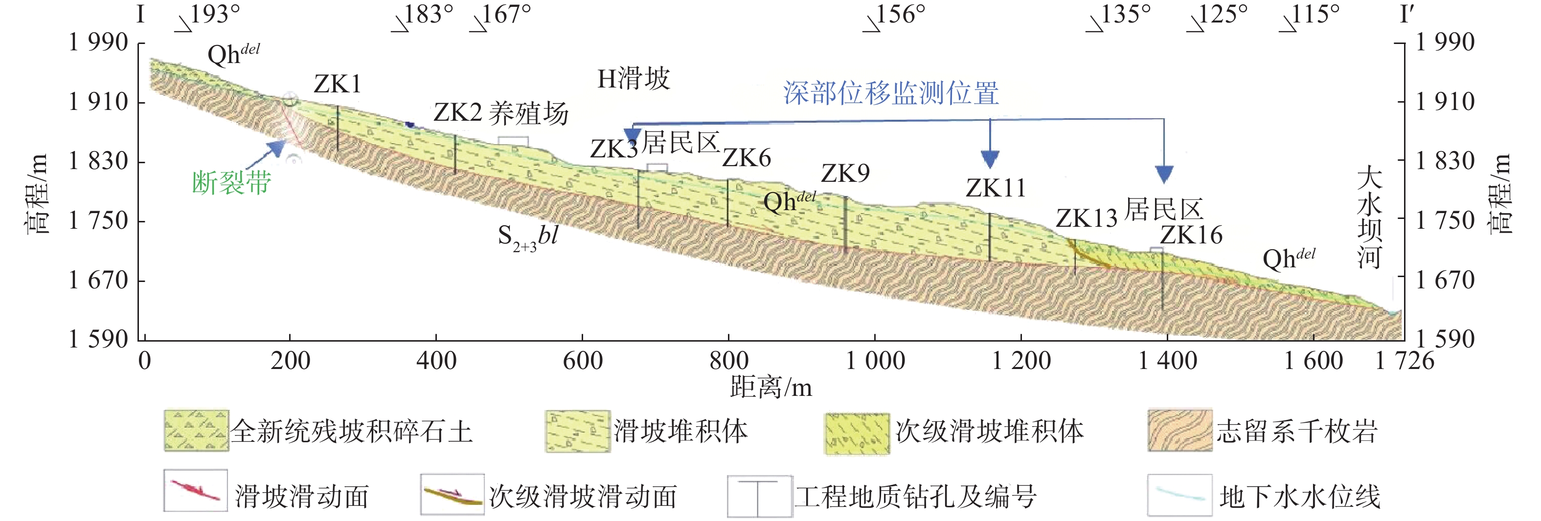
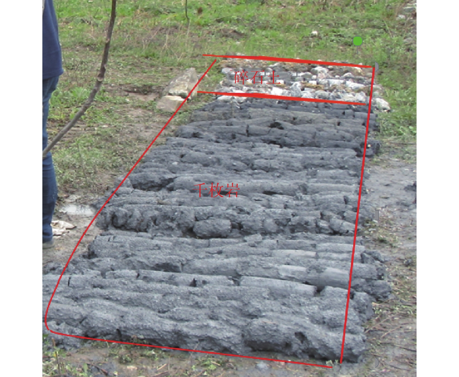
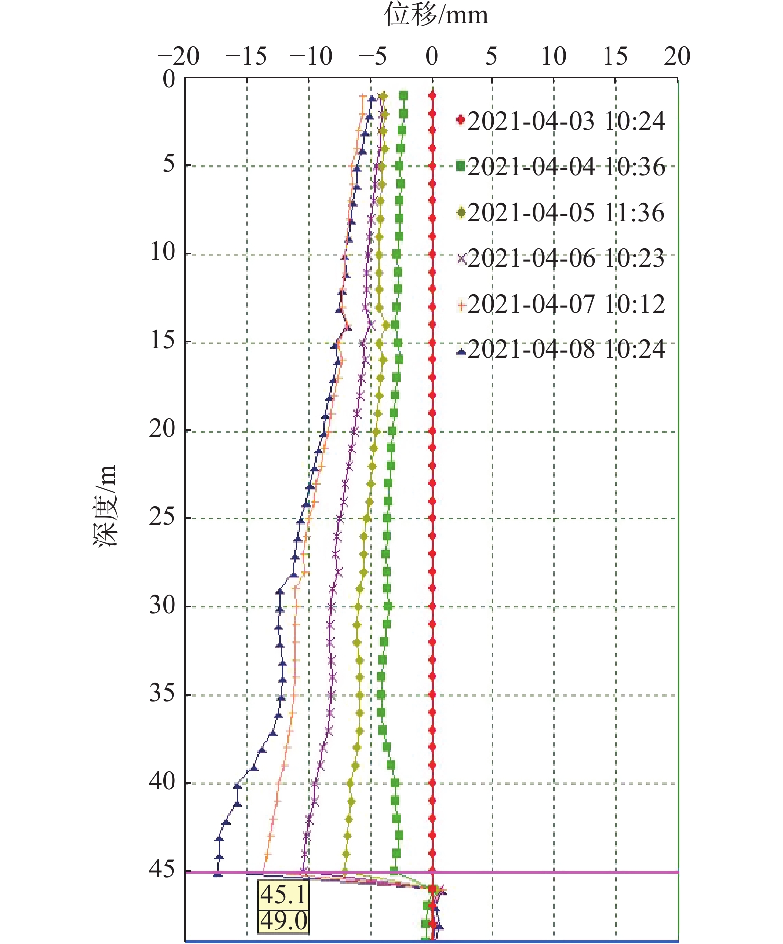
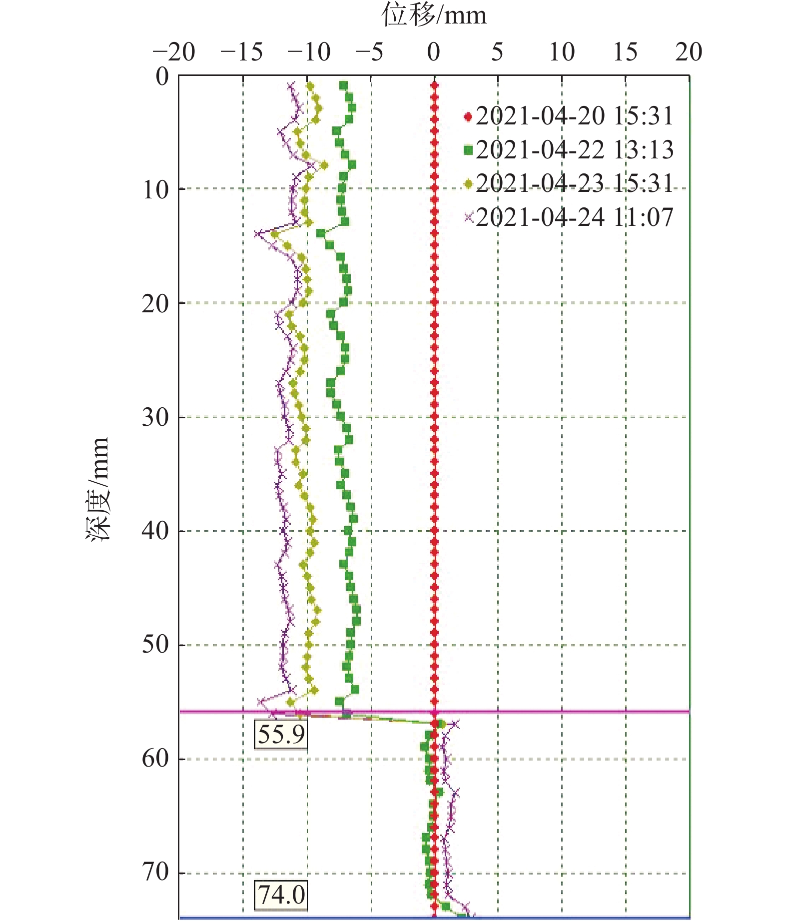
摘要: 受降雨的影响,2021年2月26—28日,舟曲县果耶镇磨里滑坡发生蠕动变形,坡体裂缝发育,变形迹象明显,共造成92户402人受灾,直接经济损失约1 446.3万元。文中以舟曲县果耶镇磨里滑坡为研究对象,通过遥感解译、无人机航拍和地质勘察等方法,深入了解磨里滑坡所处的地质环境、土体物理力学性质等,对该滑坡的成因进行了详细分析、对滑坡的稳定进行了理论计算和位移监测分析。在野外调查和钻探分析的基础上,采用Massflow数值模型对舟曲县果耶镇磨里滑坡进行数值模拟与预测,确定物源区范围及厚度以预测滑坡的堆积过程和堵江风险,预测了滑坡堵江的高度、对上下游造成的危害。结果表明:(1)磨里滑坡呈长舌状,有清晰的形态和变形特征,滑体由碎石土和破碎千枚岩组成,平均深度40 m,总体积2 120×104 m3,属特大型深层滑坡。(2)不利的地形条件、岩土体的软化、强烈的构造运动、降雨的入渗和前缘河水冲刷下切形成的临空面是发生滑坡主要因素。(3)该滑坡存在摧毁房屋道路和堵江的风险,建议尽快对受威胁采取避险搬迁措施。本研究可为类似滑坡地质灾害链的成因机制和应急防控等提供参考。Abstract: Due to the heavy rainfall, from February 26th to 28th 2021, the Moli landslide in Guoye Town, Zhouqu County, experienced creeping deformation with the development of slope cracks and obnious signs of deformation. A total of of 92 households with 402 people were affected, causing a direct economic loss of approximately 14.463 million yuan. This study focuses on the Moli landslide in Guoye Town, where the geological environment and physical and mechanical properties of the soil were deeply understood through remote sensing interpretation, aerial photography, and geological investigation. The cause of the landslide formation was analyzed in detail, and the stability of the landslide was calculated theoretically and analyzed for displacement monitoring. Based on field investigation and drilling analysis, the Massflow numerical model was used to simulate and predict the Moli landslide in Guoye Town, Zhouqu County. The range and thickness of the source area were determined to predict the accumulation process of the landslide and the risk of river blocking. The height of the river blocking and the harm caused by the landslide to the upstream and downstream regions were predicted. The results showed that: (1) Moli landslide is a super-large deep landslide with a long tongue shape, clear shape and deformation, and composed of broken phyllite and broken stone soil. The average depth of the slide body is 40m, and the total volume is 21.2 million stere. (2) The main factors of landslide formation are unfavorable topographic conditions, softening of rock and soil, strong tectonic movement, rainfall infiltration, and front river erosion. (3) The landslide has the risk of destroying the landslide houses, roads, and blocking the river. It is suggested that the residents threatened by the Moli landslide should take measures to avoid danger and relocate as soon as possible. This study can provide reference for the formation mechanism and emergency prevention and control of similar landslide geological disaster chains.
-
0. 引言
地质灾害气象风险预警是基于气象降雨因素引发地质灾害的区域性预警,是通过分析孕育地质灾害的地质特征与引发地质灾害的降水特征建立模型算法,在地质灾害易发性基础上,结合前期过程降雨和未来预报降雨,对一定区域在未来一段时间内发生地质灾害的可能性及成灾风险进行预报预警。近20年的实践表明,地质灾害气象风险预警在防御地质灾害中发挥着“指挥棒”的作用,是地质灾害风险管控的行之有效的手段。
对降雨引发的地质灾害区域预警研究,广大学者开展了大量的研究和探索。美国地质调查局1969年完成了基于泥石流临界降雨强度预警系统的开发;1985年进行了区域内大暴雨与滑坡灾害的统计分析,建立了滑坡与降雨强度的临界降雨模型,并研发了早期的滑坡灾害预警系统[1];日本学者通过对流域实况降雨与地下水渗流场分析,研究确定泥石流发生的临界降雨阈值,并实现了自动预警;学者Flentje、Chowdhury、Crozier、Emmanuel Gabet、Aleotti、Enrico Gregori等也在实时预警方面做了大量的探索工作[2 − 3]。刘传正等[4 − 5]将区域预警理论原理分为隐式统计预警、显式统计预警和动力预警三大类,并针对显式统计预警模型提出了地质灾害区域“发育度”、“潜势度”、“危险度”、“风险度”和“危害度”等“五度”递进分析理论方法。刘艳辉等[6]在显式统计预警模型中采用确定系数方法实现了区域预警潜势度的计算,解决了地质灾害区域预警模型方法的难题,地质灾害气象预警工作逐步在全国山区省、市、县开展。以上研究成果多偏重于技术层面,对地质灾害防治管理体制机制方面的探索涉及较少。
在近20年的地质灾害气象风险预报预警工作实践中,因缺少统一的系统建设标准和成果发布规范,这种省、市、县各自建设的地质灾害气象预警系统经常会出现结果不统一、数据共享难、更新时效差、平台功能不完善等问题,导致同区域同时段出现不同预警等级和重复预警的现象,给基层应急响应和防灾处置工作带来一定困扰,对预警信息发布的严肃性和权威性造成不利影响[7 − 11]。2018年以来,浙江、四川、福建、云南等省份率先探索地质灾害省-市-县一体化预警平台建设,在数据资源高效共享、预警结果同台会商、预警信息统一发布等方面取得了较大进步,形成了不同模式的省-市-县一体化地质灾害风险预警体系。下面以浙江省为例介绍省-市-县一体化地质灾害风险预警系统建设。
1. 工作概况
1.1 浙江省地质背景及地质灾害概况
浙江省地处我国东南沿海,地貌类型多样,主要以中低山丘陵为主;地质构造复杂,以江山-绍兴深断裂带为界,横跨“扬子台地”(江南地层区)和“华南褶皱系”(华南地层区)两大Ⅰ级地质构造单元;降雨丰沛,梅汛期降雨持续时间长,台风降雨强度大。同时,人类工程活动强烈、人口密度大,容易引发地质灾害。浙江省地质灾害易发区占到全省陆域面积的73%(图1),地质灾害规模虽以小型为主,但时常造成较大的人员伤亡和经济损失。据统计,全省已发生突发性地质灾害灾情6343处,造成296人死亡、15人失踪、102人受伤,直接经济损失10.17亿元。截至2023年11月,全省现有地质灾害隐患点422处,地质灾害风险防范区16934处,威胁6.99万户22.2万人,威胁财产173.8亿元。
1.2 地质灾害预警工作概况
2003年浙江省自然资源厅与省气象局联合开展地质灾害预报预警工作,截至2023年,全省因地质灾害预警成功避险地质灾害532起,避免人员伤亡5564人,避免经济损失6252.5万元,取得了良好成效。为提升地质灾害预报预警精准度,2005年完成了市级1∶5万市级地质灾害预警系统,实现了省、市地质灾害分级预报预警;2007年为强化山区实况降雨对地质灾害的影响,将水利部门监测实况雨量纳入地质灾害预警系统,提升了地质灾害预报预警精度;2009年为有效防范局地强降雨引发地质灾害,研发了3 h短临预警系统;2013年针对预警对象研发了全国首个基于斜坡单元的地质灾害预警系统[12];2019年为进一步提升预警精度,采用均一单元升级了地质灾害预警系统[13];2020年,自然资源部在浙江实施地质灾害风险隐患“双控”试点,针对新调查的地质灾害风险防范区研发了以临界降雨为基础的1 h实时预警系统[14]。同时,将24 h每日预报、3 h短临预报和1 h的实时预警三种模式的地质灾害气象风险预报预警模型,并按照“省级预报到县、市级预报到乡、县级预警到村(点)”的工作原则,初步建成了省-市-县一体化地质灾害气象风险预报预警系统[15],并制定了《浙江省突发性地质灾害风险预报预警技术要求(试行)》,对全省地质灾害预报预警业务进行了规范。
2. 地质灾害风险预警一体化建设
2.1 预警工作内容
浙江省地质灾害气象风险预报预警时间尺度如图2所示,可分为趋势预测、等级预报和实时预警三类。
(1)趋势预测:根据气象部门阶段性降雨预测,按年度、季度、月度及重点时段(节假日和重要活动等)开展地质灾害风险趋势预测,研究确定本阶段是否可能存在地质灾害风险较高及以上区域、重点风险地段和风险点,以及相应时段,并提出本阶段地质灾害防范工作建议。
(2)风险预报:包括未来24 h地质灾害气象风险等级预报和未来3 h短临预报。根据气象部门未来24 h预报雨量和前期实况雨量,结合地质环境条件开展地质灾害风险区域预报,提醒预报区域防灾管理人员及时开展地质灾害防范工作;强降雨时段,结合实际工作需求,加密预报频次,根据气象部门未来3 h预报雨量和前期实况雨量,开展地质灾害气象风险3 h短临预报;台风暴雨时段开展48/72 h短期风险预报。风险预报为区域概率预报,预报层级最小到乡镇级。
(3)实时预警:通过研究设定地质灾害隐患点和风险防范区降雨阈值,结合周边雨量监测站监测的实时降雨开展地质灾害风险实时预警,并向地质灾害隐患点和风险防范区管理人员逐小时发布风险预警信息,指导基层开展地质灾害巡查和受威胁人员转移避险。实时预警是对区域概率预报的补充和矫正。
通过全面梳理省、市、县三级地质灾害风险预报预警业务工作需求,我省确定“省预报到县,市预报到乡,县预警到村(点)”的工作要求,省、市自然资源主管部门结合预报产品,以行政区划为单位,发布风险“五色图”,提醒各级部门依据工作职责,做好地质灾害防治工作;县级自然资源主管部门对地质灾害风险防范区和隐患点开展实时预警,实时发布风险预警信息,精准指导地质灾害影响人员转移避险,工作体系架构见图3。
![]() 图 3 预报预警工作结构框架图Figure 3. Structure framework diagram of forecast and early warning work
图 3 预报预警工作结构框架图Figure 3. Structure framework diagram of forecast and early warning work2.2 通用模型算法
通用模型是在全省地质灾害基础上统一研发的地质灾害气象风险预报预警模型,各市可直接调用,也可自行研发不同的预报预警模型。通用模型主要是通过区域地质灾害机理研究,确定地质灾害敏感因子和诱发因子,应用相关性原理建立地质灾害易发性评价指标体系,综合评价不同区域地质灾害易发程度,结合地质灾害与降雨量的关系分析,基于逻辑回归的概率预报方法,构建地质灾害气象风险预报预警模型,包含省市3 h短时预报、24 h常规预报、48/72 h趋势预测模型,开展区域地质灾害风险等级预报。县级实时预警模型主要面向地质灾害风险防范区和隐患点开展,根据降雨强度-历时(I-D曲线)确定临界降雨阈值,利用实时降雨与临界降雨阈值判别矩阵开展实时预警工作。
2.2.1 省市等级预报模型方法
省级预报模型主要采用主成分逻辑回归方法(图4),以地质灾害赋存环境条件均一的不规则单元为预报对象,对已发生地质灾害影响因子进行主成分分析,最终确定坡度、坡向、高程、地层岩性、断裂构造、工程地质岩组,土地利用及植被类型共8个因子作为地质灾害敏感因子。其中省级预报模型以全省山地丘陵区为地质灾害预报预警范围构建32.5万余评价单元,对预警单元进行地质灾害危险性指标(G)进行计算,通过危险度与降雨条件(降水指数)的相关及回归分析,确立预警指数数学表达式(式1)。
![]() 图 4 地质灾害气象风险预报模型方法Figure 4. Methodology of geological hazard meteorological risk prediction model
图 4 地质灾害气象风险预报模型方法Figure 4. Methodology of geological hazard meteorological risk prediction model$$ T={k}_{0}G+{k}_{1}({R}_{{\mathrm{a}}}+{R}_{{\mathrm{f}}})/{R}_{0}+e $$ (1) 式中:
$ T $ ——预警指数;${G} $ ——地质灾害危险性指标;$ {R}_{{\mathrm{a}}} $ ——前期有效降雨;$ {R}_{{\mathrm{f}}} $ ——预报降雨;$ {R}_{0} $ ——降雨区划;$ {k}_{0} $ 、$ {k}_{1} $ ——回归系数;e——修正值。
经过统计分析,浙江省大部分地质灾害均在强降雨当天发生,而地质灾害发生前3 d有降雨的占83.9%,前7 d累计降雨与地质灾害发生数相关程度非常高[7]。根据实际降雨与地质灾害发生情况复盘分析,短临预报通常考虑前24 h有效雨量,每日预报和短期预报考虑前7日累计有效雨量符合浙江省地质灾害发生与降雨强度规律[12 − 13]。
市级预报模型除宁波采用斜坡单元外,其余均采用200~500 m精度的网格单元,因东西部地质条件差异和降雨类型(台风暴雨和梅雨)不同,采用的地质灾害影响因子和前期降雨稍有不同,均采用逻辑回归的方法建立市级预报模型。
2.2.2 县级实时预警模型方法
预警模型主要采用降雨强度-历时(I-D曲线)的临界降雨阈值方法[14 − 16]。浙江省以县级行政区划为单元,统计分析历史发生的地质灾害降雨强度(I)和降雨历时(D)的关系,在对数坐标下,以数据分布(式2)的下限作为该县(市、区)的降雨阈值曲线(I-D曲线),并根据该曲线,提取不同历时(1 h、3 h、6 h、12 h、24 h)的黄、橙、红临界降雨阈值来实施地质灾害实时预警(图5)。目前,依托乡镇地质灾害风险调查项目,根据地质灾害体的破坏和变形情况、受灾体的风险承受差异等指标,逐步实现更为精细的“一坡一阈值”风险动态调整机制。
![]()
$$ R(H)=a{H}^{b} $$ (2) 式中:
$ R(H) $ ——降雨强度;$ H $ ——降雨时长;$ a $ ——比例系数;$ b $ ——幂指数。2.3 预警系统建设
根据地质灾害气象风险预警业务需求,采用节点建设模式,基于云计算技术研发了省市县一体化预报预警平台,平台由数据中心、数据中台及应用场景组成。数据中心主要负责数据采集、存储和管理等,包含数据仓、模型仓、功能仓和节点仓,每个节点仓保存各自的业务库、雨量库和成果库;数据中台主要负责数据调用、治理和共享,为全省预报预警一体化业务提供数据节点管理、功能调用、综合展示、运维监控和共享管理等功能;应用场景包括等级预报子系统、实时预警子系统、其他预警子系统和会商平台[15]。平台基础设施如服务器、网络及安全防护等资源由省级统一建设,市县级应用场景按照标准格式,调用省数据中心数据,结合当地气象、水利部门降雨数据进行地质灾害等级预报和实时预警,并将预警响应数据反馈数据中心,形成闭环管理。系统实现了跨部门多层级业务融合和数据共性支撑全省复用,同时,预报预警产品通过数据服务接口,实时为地质灾害防治业务场景、防汛防台在线等提供预警成果共享服务。
2.3.1 等级预报子系统
等级预报子系统主要在建设省、市两级,是开展地质灾害区域风险分析的专业系统,包含数据获取处理、模型分析计算、人工会商干预、预报产品制作和预报产品发布等功能。各级子系统通过专线将各级气象降雨预报数据导入数据中心,通过模型计算形成初级预报结果,上传会商中心进行全省会商研判,各市根据研判结果分别制作市、县预报产品进行发布,省级部门对各市产品进行综合,形成地质灾害风险等级预报“五色图”进行发布。同时,省部门根据气象3 h降雨预报数据实施自动化短临预警提醒。
2.3.2 实时预警子系统
实时预警子系统主要建设在县级,是针对地质灾害隐患点、风险防范区和重点乡村进行实时自动化预警,每小时发布风险预警信息。主要功能包括数据获取处理、预警分析研判和预警结果发布等。县级实时预警系统将地质灾害风险防范区或隐患点关联周边气象和水文部门雨量监测站,利用监测降雨量与1 h、3 h、6 h、12 h、24 h的黄、橙、红临界降雨阈值进行对比研判,采用不同历时的最高预警等级作为当前地质灾害风险防范区或隐患点的预警级别,并逐小时更新。
2.3.3 任务闭环和监管系统
为保证地质灾害风险预报预警信息的任务闭环和可视化监管,一体化预警平台研发了风险防控驾驶舱和移动应用终端“地灾智防”APP。通过移动终端,实时查询地质灾害等级预报、实时预警、专业监测预警等预警信息,实现防灾指令的实时贯通和防灾数据的及时汇集;通过驾驶舱大屏,各级自然资源主管部门可以查看台风降雨、等级预报、实时预警、值班值守、巡查排查、驻县进乡、灾险情处置、防治工作等信息,切实提升浙江省地质灾害防治指挥决策的时效性和科学性。
2.3.4 预警闭环管控机制
“省级预报到县、市级预报到乡、县级预警到村(点)”工作体系是浙江省地质灾害气象风险预报预警一体化工作机制的重要内容之一。省级通过一体化平台省级节点,开展3 h、24 h等多时段地质灾害风险等级预报,发布范围覆盖省级有关部门和市、县自然资源主管部门;市级地质灾害风险等级预报成果范围覆盖市级有关部门和县级自然资源主管部门和乡镇(街道);县级通过气象、水利部门的实况降雨数据,结合风险降雨阈值,针对地质灾害隐患点、风险防范区和重点乡村等开展实时预警,发布范围覆盖县级有关部门和乡(镇街道)村(社区)责任人和群测群防员(图6)。
![]() 图 6 一体化地质灾害风险预报预警系统框架图Figure 6. Framework diagram of integrated geological hazard risk forecast and early warning system
图 6 一体化地质灾害风险预报预警系统框架图Figure 6. Framework diagram of integrated geological hazard risk forecast and early warning system“有预警就有响应,有响应务必闭环”是一体化工作机制的另一重要内容,根据省、市、县三级在不同防御阶段的地质灾害风险管控要求,围绕地质灾害风险预报预警结果,移动终端发布预报预警信息,派发巡查处置任务,并回流基层地质灾害防治工作反馈情况,实现地质灾害风险预报预警响应的闭环管控。通过驾驶舱大屏,实现地质灾害风险信息和防治业务信息的可视化展示,消息和任务的全生命周期监控,配合“叫应叫醒”工作机制,保证信息的贯通,落实闭环管理。
3. 典型预警案例
受2023年5号台风“杜苏芮”影响,温州南部地区遭受持续强降雨。2023年7月26日18时,省级预警系统对温州市平阳县发布未来24 h地质灾害气象风险橙色预警,温州市预警系统对平阳县顺溪镇发布未来24 h地质灾害气象风险橙色预警。27日8时省、市预警级别均升级为红色预警(图7),值班人员第一时间电话叫应当地政府主要领导。顺溪镇人民政府立即组织开展隐患点和风险防范区人员转移工作,11时将顺溪镇下东村风险防范区(编号330326FF0263)受威胁的5人提前转移至避灾场所。27日13时县级实时预警系统(基于临界降水阈值模型)对该处风险防范区发布黄色预警,并生成巡查任务,群测群防员立即开展巡查,并通过“地灾智防”APP反馈巡查和人员转移情况。14时省级预警系统对平阳县再次加密发布未来3 h短临红色预警,15时该处专业监测设备也发出红色报警,16时该风险防范区发生滑坡,体积约300 m3。滑坡造成坡脚房屋墙体和窗户局部损毁和屋内泥水淤积(图8)。由于预警及时精准,人员提前撤离,成功避免1户5人伤亡。本起案例是基于省-市-县一体化预警工作体系,逐级逐步精准发布预警信息、有效落实闭环管控、成功避免人员伤亡的典型案例。
![]() 图 7 地质灾害风险预警综合展示图Figure 7. Comprehensive display of geological disaster risk early warning
图 7 地质灾害风险预警综合展示图Figure 7. Comprehensive display of geological disaster risk early warning![]() 图 8 温州市平阳县顺溪镇下东村滑坡Figure 8. Landslide at Xiadong Village, Shunxi Town, Pingyang County, Wenzhou City
图 8 温州市平阳县顺溪镇下东村滑坡Figure 8. Landslide at Xiadong Village, Shunxi Town, Pingyang County, Wenzhou City4. 结论
(1)浙江省通过构建“省级预报到县、市级预报到乡、县级预警到村(到点)”预报预警一体化工作体系,依托“地灾智防”APP等数字化手段,加强了预报预警与预警响应联动,建立预警响应闭环工作机制,实现了地质灾害气象风险预警响应闭环管理。
(2)浙江省通过开展地质灾害气象风险预警一体化建设,在模型构建、系统建设、数据共享和闭环管控机制建设等方面形成了一套较为完整的技术和管理体系,为其他省市开展预警一体化建设提供了较为成熟的应用示范。
(3)浙江省预报预警一体化系统自上线以来,运行效果良好,工作成效显著,有效支撑了全省地质灾害防治工作。但由于预报降雨数据更新和实况降雨数据校正的滞后性,导致地质灾害风险预警结果实时性不足,在与气象、水利部门数据协同机制方面仍需进一步加强。
-
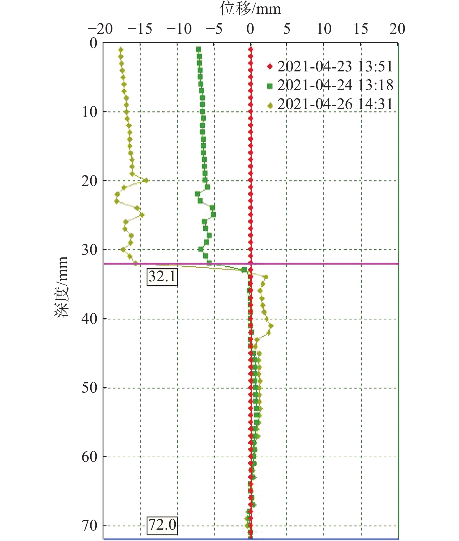
![]()
图 8 磨里滑坡降轨InSAR观测结果
Figure 8. InSAR observation results of the Moli landslide descending track
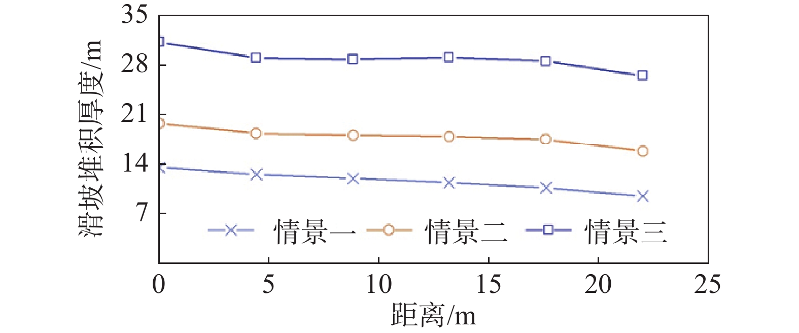
![]()
图 9 不同情景下滑坡堆积厚度
Figure 9. The thickness of landslide accumulation under different scenarios
![]()
图 10 不同情景下河道内滑坡坝堆积厚度
Figure 10. The thickness of landslide dam accumulation in river under different scenarios
![]()
图 11 不同滑坡堆积结果的溃决洪水演进过程
Figure 11. Outburst flood evolution of landslides with different accumulation results
![]()
图 12 不同滑坡堆积结果漫顶时流深
Figure 12. Flow depth at the top of landslide with different accumulation deposits
表 1 滑块滑带土取值表
Table 1 Property table of the soils at slide block slip zone
状态 容重/( kN·m−3) 强度指标 实验标准值 反演值 采用值 天然 18 c/kPa 20.5 19.9 20.2 φ/(°) 16.3 15.9 16.1 饱和 24 c/kPa 18.5 17.9 18.2 φ/(°) 15.3 14.9 15.1  下载: 导出CSV
表 2 滑坡体稳定性成果汇总表
Table 2 Summary table of landslide stability results
计算工况 稳定系数 稳定状态 工况1:自重 1.070 基本稳定 工况2:自重+暴雨 0.925 不稳定 工况3:自重+地震 0.835 不稳定
下载: 导出CSV
表 3 滑坡动力过程模拟假设情景与参数
Table 3 Simulation scenarios and parameters for landslide dynamic process
情景 滑带土含水率/% 黏聚力/kPa 内摩擦角/(°) 情景一 6 54.79 35 情景二 18 23.05 24 情景三 30 0.21 15
下载: 导出CSV
表 4 溃决洪水演进过程模拟假设情景与参数
Table 4 Simulation scenarios and parameters for evaluation of outburst flood
情景 河流流量
/(m3·s−1)曼宁
系数抗剪强度
系数床负载
系数模拟时长
/h情景四 20 0.04 0.13 1.5 15 情景五 15 0.04 0.13 1.5 15
下载: 导出CSV
-
[1] 胡卸文,黄润秋,朱海勇,等. 唐家山堰塞湖库区马铃岩滑坡地震复活效应及其稳定性研究[J]. 岩石力学与工程学报,2009,28(6):1270 − 1278. [HU Xiewen,HUANG Runqiu,ZHU Haiyong,et al. Earthquake reactivation effects and stability study of Malingyan landslide in Tangjiashan dammed lake[J]. Chinese Journal of Rock Mechanics and Engineering,2009,28(6):1270 − 1278. (in Chinese with English abstract) HU Xiewen, HUANG Runqiu, ZHU Haiyong, et al. Earthquake reactivation effects and stability study of malingyan landslide in Tangjiashan dammed lake[J]. Chinese Journal of Rock Mechanics and Engineering, 2009, 28(6): 1270-1278. (in Chinese with English abstract)
[2] 卢万年. 用空气动力学分析坡体高速滑坡的滑行问题[J]. 地球科学与环境学报,1991,13(4):77 − 85. [LU Wannian. Airo-dynamic approach to sliding problems of high landslide[J]. Journal of Earth Science and Enivronmental,1991,13(4):77 − 85. (in Chinese with English abstract) LU Wannian. Airo-dynamic approach to sliding problems of high landslide[J]. Journal of Earth Science and Enivronmental, 1991, 13(4): 77-85. (in Chinese with English abstract)
[3] 黄润秋, 王士天, 张悼元. 斜坡岩体高速滑动的“滚动摩擦”机制[C]//工程地质科学新进展. 成都: 成都科技大学出版社, 1989: 318 − 325 HUANG Runqiu, WANG Shitian, ZHANG Daoyuan. “Rolling friction” mechanism “A” for high-speed sliding of slope rock mass[C]//New Progress in engineering geology. Chengdu: Chengdu University of Science and Technology Press, 1989: 318 − 325. (in Chinese)
[4] 胡广韬,赵法锁,李丽,等. 基岩地区高速滑坡的多级冲程与超前溅泥气浪[J]. 地球科学与环境学报,1988,10(1):79 − 87. [HU Guangtao,ZHAO Fasuo,LI Li,et al. Multiple-stroking of high-speed landslides and overstepping gas billows including mud in bed rock areas[J]. Journal of Earth Science and Enivronmental,1988,10(1):79 − 87. (in Chinese with English abstract) HU Guangtao, ZHAO Fasuo, LI Li, et al. Multiple-stroking of high-speed landslides and overstepping gas billows including mud in bed rock areas[J]. Journal of Earth Science and Enivronmental, 1988, 10(1): 79-87. (in Chinese with English abstract)
[5] 廖军,邓涛,周越良,等. 降雨作用下第四系堆积体路堤稳定性[J]. 科学技术与工程,2021,21(23):10090 − 10097. [LIAO Jun,DENG Tao,ZHOU Yueliang,et al. Stability of quaternary accumulation embankment under rainfall[J]. Science Technology and Engineering,2021,21(23):10090 − 10097. (in Chinese with English abstract) LIAO Jun, DENG Tao, ZHOU Yueliang, et al. Stability of quaternary accumulation embankment under rainfall[J]. Science Technology and Engineering, 2021, 21(23): 10090-10097. (in Chinese with English abstract)
[6] 云烨,吕孝雷,付希凯,等. 星载InSAR技术在地质灾害监测领域的应用[J]. 雷达学报,2020,9(1):73 − 85. [YUN Ye,LYU Xiaolei,FU Xikai,et al. Application of spaceborne interferometric synthetic aperture radar to geohazard monitoring[J]. Journal of Radars,2020,9(1):73 − 85. (in Chinese with English abstract) YUN Ye, LÜ Xiaolei, FU Xikai, et al. Application of spaceborne interferometric synthetic aperture radar to geohazard monitoring[J]. Journal of Radars, 2020, 9(1): 73-85. (in Chinese with English abstract)
[7] 代聪,李为乐,陆会燕,等. 甘肃省舟曲县城周边活动滑坡InSAR探测[J]. 武汉大学学报(信息科学版),2021,46(7):994 − 1002. [DAI Cong,LI Weile,LU Huiyan,et al. Active landslides detection in Zhouqu County,Gansu Province using InSAR technology[J]. Geomatics and Information Science of Wuhan University,2021,46(7):994 − 1002. (in Chinese with English abstract) DAI Cong, LI Weile, LU Huiyan, et al. Active landslides detection in Zhouqu County, Gansu Province using InSAR technology[J]. Geomatics and Information Science of Wuhan University, 2021, 46(7): 994-1002. (in Chinese with English abstract)
[8] 张国帅,王晓亮,夏建新. 入渗条件下颗粒堆积体稳定性试验研究[J]. 泥沙研究,2021,46(5):68 − 73. [ZHANG Guoshuai,WANG Xiaoliang,XIA Jianxin. Experimental study on stability of particle accumulation under infiltration[J]. Journal of Sediment Research,2021,46(5):68 − 73. (in Chinese with English abstract) ZHANG Guoshuai, WANG Xiaoliang, XIA Jianxin. Experimental study on stability of particle accumulation under infiltration[J]. Journal of Sediment Research, 2021, 46(5): 68-73. (in Chinese with English abstract)
[9] 石固林,徐浪,张璇钰,等. 西山村滑坡时序形变的SBAS-InSAR监测[J]. 测绘科学,2021,46(2):93 − 98. [SHI Gulin,XU Lang,ZHANG Xuanyu,et al. Monitoring time series deformation of Xishancun landslide with SBAS-InSAR[J]. Science of Surveying and Mapping,2021,46(2):93 − 98. (in Chinese with English abstract) SHI Gulin, XU Lang, ZHANG Xuanyu, et al. Monitoring time series deformation of Xishancun landslide with SBAS-InSAR[J]. Science of Surveying and Mapping, 2021, 46(2): 93-98. (in Chinese with English abstract)
[10] 朱庆,曾浩炜,丁雨淋,等. 重大滑坡隐患分析方法综述[J]. 测绘学报,2019,48(12):1551 − 1561. [ZHU Qing,ZENG Haowei,DING Yulin,et al. A review of major potential landslide hazards analysis[J]. Acta Geodaetica et Cartographica Sinica,2019,48(12):1551 − 1561. (in Chinese with English abstract) ZHU Qing, ZENG Haowei, DING Yulin, et al. A review of major potential landslide hazards analysis[J]. Acta Geodaetica et Cartographica Sinica, 2019, 48(12): 1551-1561. (in Chinese with English abstract)
[11] 张雨林,石惊涛,涂国祥,等. 粗、巨颗粒富集位置对堆积体降雨入渗的影响[J]. 水利水运工程学报,2021(5):76 − 83. [ZHANG Yulin,SHI Jingtao,TU Guoxiang,et al. Influence of coarse and giant particles enrichment position on rainfall infiltration of accumulation body[J]. Hydro-Science and Engineering,2021(5):76 − 83. (in Chinese with English abstract) ZHANG Yulin, SHI Jingtao, TU Guoxiang, et al. Influence of coarse and giant particles enrichment position on rainfall infiltration of accumulation body[J]. Hydro-Science and Engineering, 2021(5): 76-83. (in Chinese with English abstract)
[12] 柴贺军,刘汉超,张倬元. 中国滑坡堵江的类型及其特点[J]. 成都理工学院学报,1998,25(3):411 − 416. [CHAI Hejun,LIU Hanchao,ZHANG Zhuoyuan. Study on the categories of landslide damming of rivers and their characteristics[J]. Journal of Chengdu University of Technology,1998,25(3):411 − 416. (in Chinese with English abstract) CHAI Hejun, LIU Hanchao, ZHANG Zhuoyuan. Study on the categories of landslide damming of rivers and their characteristics[J]. Journal of Chengdu University of Technology, 1998, 25(3): 411-416. (in Chinese with English abstract)
[13] 李娜. 云南省滑坡堵江灾害及其对策[C]// 滑坡文集(9). 北京: 铁道出版社, 1992 LI Na. Landslide Blocking River disaster in Yunnan Province and its countermeasures[C]// Landslide Essays (9). Beijing: Railway Press, 1992. (in Chinese)
[14] 柴贺军,刘汉超,张倬元. 滑坡堵江的基本条件[J]. 地质灾害与环境保护,1996,7(1):41 − 46. [CHAI Hejun,LIU Hanchao,ZHANG Zhuoyuan. The main conditions of landslide dam[J]. Journal of Geological Hazards and Enveronment Preservation,1996,7(1):41 − 46. (in Chinese with English abstract) CHAI Hejun, LIU Hanchao, ZHANG Zhuoyuan. The main conditions of landslide dam[J]. Journal of Geological Hazards and Enveronment Preservation, 1996, 7(1): 41-46. (in Chinese with English abstract)
[15] 于宝国,边波,李春龙,等. 基于知识图谱的碎石土堆积体滑坡研究热点及发展趋势[J]. 地球科学前沿(汉斯),2021(10):1326 − 1340. [YU Baoguo,BIAN Bo,LI Chunlong,et al. Research hotspot and development trend of gravel soil accumulation landslide based on knowledge graph[J]. Frontiers of Earth Science (Hans),2021(10):1326 − 1340. (in Chinese with English abstract) YU B G, BIAN B, LI C L, et al. Research hotspot and development trend of gravel soil accumulation landslide based on knowledge graph[J]. Frontiers of Earth Science (Hans), 2021(10): 1326-1340. (in Chinese with English abstract)
[16] 李忠生. 国内外地震滑坡灾害研究综述[J]. 灾害学,2003,18(4):64 − 70. [LI Zhongsheng. The state of the art of the research on seismic landslide hazard at home and abroad[J]. Journal of Catastrophology,2003,18(4):64 − 70. (in Chinese with English abstract) LI Zhongsheng. The state of the art of the research on seismic landslide hazard at home and abroad[J]. Journal of Catastrophology, 2003, 18(4): 64-70. (in Chinese with English abstract)
[17] 方玉树. 超大型滑坡动力学问题研究[J]. 水文地质工程地质, 1988, 15(6): 20 − 24 FANG Yushu. Study on dynamic problems of super-large landslide[J]. Hydrogeology & Engineering Geology, 1988, 15(6): 20 − 24. (in Chinese with English abstrac)
[18] 刘建康,程尊兰,佘涛. 云南鲁甸红石岩堰塞湖溃坝风险及其影响[J]. 山地学报,2016,34(2):208 − 215. [LIU Jiankang,CHENG Zunlan,SHE Tao. Assessment of dam failure and secondary hazards for hongshiyan dammed lake caused by Ludian earthquake in Niulanjiang river[J]. Mountain Research,2016,34(2):208 − 215. (in Chinese with English abstract) LIU Jiankang, CHENG Zunlan, SHE Tao. Assessment of dam failure and secondary hazards for hongshiyan dammed lake caused by Ludian earthquake in niulanjiang river[J]. Mountain Research, 2016, 34(2): 208-215. (in Chinese with English abstract)
[19] 贺小黑,彭鑫,谭建民,等. 地下水渗流对崩坡积滑坡稳定性和变形的影响—以湖南安化春风滑坡群为例[J]. 中国地质灾害与防治学报,2020,31(6):96 − 103. [HE Xiaohei,PENG Xin,TAN Jianmin,et al. Influence of groundwater seepage on stability and deformation of colluvial deposit landslide:Taking Chunfeng landslide group in Anhua County of Hunan Province as an example[J]. The Chinese Journal of Geological Hazard and Control,2020,31(6):96 − 103. (in Chinese with English abstract) HE Xiaohei, PENG Xin, TAN Jianmin, et al. Influence of groundwater seepage on stability and deformation of colluvial deposit landslide: taking Chunfeng Landslide group in Anhua County of Hunan Province as an example[J]. The Chinese Journal of Geological Hazard and Control, 2020, 31(6): 96-103. (in Chinese with English abstract)
[20] TANG Y M,SHU H P,XUE Q A,et al. Field monitoring-based and theoretical analysis of Baota Mountain landslide stability[J]. Advances in Civil Engineering,2021:1 − 16.
[21] FLAGEOLLET J C,MAQUAIRE O,MARTIN B,et al. Landslides and climatic conditions in the Barcelonnette and Vars Basins (Southern French Alps,France)[J]. Geomorphology,1999,30(1/2):65 − 78.
[22] 杨伟东, 王再旺, 赵涵卓, 等. 基于APSO-SVR-GRU模型的白水河滑坡周期项位移预测[J]. 中国地质灾害与防治学报,2022,33(6):20 − 28. [YANG Weidong, WANG Zaiwang, ZHAO Hanzhuo, et al. Displacement prediction of periodic term of Baishuihe landslide based on APSO-SVR-GRU model[J]. The Chinese Journal of Geological Hazard and Control,2022,33(6):20 − 28. (in Chinese with English abstract) YANG Weidong, WANG Zaiwang, ZHAO Hanzhuo, et al. Displacement prediction of periodic term of Baishuihe landslide based on APSO-SVR-GRU model[J]. The Chinese Journal of Geological Hazard and Control, 2022, 33(6): 20-28.(in Chinese with English abstract)
[23] 郭富赟, 周小龙, 火飞飙, 等. 舟曲断裂带滑坡灾害效应与防治对策研究[J]. 中国地质灾害与防治学报,2022,33(6):80 − 89. [GUO Fuyun, ZHOU Xiaolong, HUO Feibiao, et al. Study on the disaster effect and prevention countermeasures of landslide in Zhouqu fault zone[J]. The Chinese Journal of Geological Hazard and Control,2022,33(6):80 − 89. (in Chinese with English abstract) GUO Fuyun, ZHOU Xiaolong, HUO Feibiao, et al. Study on the disaster effect and prevention countermeasures of landslide in Zhouqu fault zone[J]. The Chinese Journal of Geological Hazard and Control, 2022, 33(6): 80-89.(in Chinese with English abstract)
[24] 李彩虹, 李雪, 郭长宝, 等. 青藏高原东部鲜水河断裂带地震滑坡危险性评价[J]. 地质通报,2021,41(8):1473 − 1486. [LI Caihong, LI Xue, GUO Changbao, et al. Seismic landslide hazards assessment along the Xianshuihe fault zone, Tibetan Plateau, China[J]. Geological Bulletin of China,2021,41(8):1473 − 1486. (in Chinese with English abstract) LI Caihong, LI Xue, GUO Changbao, et al. Seismic landslide hazards assessment along the Xianshuihe fault zone, Tibetan Plateau, China[J]. Geological Bulletin of China, 2022, 41(8): 1473-1486.(in Chinese with English abstract)
[25] 魏占玺, 谢东武, 毋远召, 等. 基于动态残余强度的不同含水率条件下滑坡稳定性研究[J]. 水文地质工程地质,2022,49(2):126 − 136. [WEI Zhanxi, XIE Dongwu, WU Yuanzhao, et al. Research on landslide stability under different water content conditions based on the dynamic residual strength[J]. Hydrogeology & Engineering Geology,2022,49(2):126 − 136. (in Chinese with English abstract) WEI Zhanxi, XIE Dongwu, WU Yuanzhao, et al. Research on landslide stability under different water content conditions based on the dynamic residual strength[J]. Hydrogeology & Engineering Geology, 2022, 49(2): 126-136.(in Chinese with English abstract)
[26] 田尤, 陈龙, 黄海, 等. 西藏澜沧江流域察雅县城滑坡群成因及现状稳定性[J]. 地质通报,2021,40(12):2034 − 2042. [TIAN You, CHEN Long, HUANG Hai, et al. Origin and stability of landslides in Chaya County, Lancang River Basin, Tibet[J]. Geological Bulletin of China,2021,40(12):2034 − 2042. (in Chinese with English abstract) TIAN You, CHEN Long, HUANG Hai, et al. Origin and stability of landslides in Chaya County, Lancang River Basin, Tibet[J]. Geological Bulletin of China, 2021, 40(12): 2034-2042.(in Chinese with English abstract)
[27] 韩旭东, 付杰, 李严严, 等. 舟曲江顶崖滑坡的早期判识及风险评估研究[[J]. 水文地质工程地质,2021,48(6):180 − 186. [HAN Xudong, FU Jie, LI Yanyan, et al. A study of the early identification and risk assessment of the Jiangdingya landslide in Zhouqu County[J]. Hydrogeology & Engineering Geology,2021,48(6):180 − 186. (in Chinese with English abstract) HAN Xudong, FU Jie, LI Yanyan, et al. A study of the early identification and risk assessment of the Jiangdingya landslide in Zhouqu County[J]. Hydrogeology & Engineering Geology, 2021, 48(6): 180-186.(in Chinese with English abstract)
-
期刊类型引用(1)
1. 曾新雄,刘佳,赖波,赵风顺,江山. 广东珠海市降雨型崩塌滑坡预警阈值研究. 中国地质灾害与防治学报. 2024(05): 141-150 .  本站查看
本站查看
其他类型引用(0)


计量
- 文章访问数:
- HTML全文浏览量:
- PDF下载量:
- 被引次数: 1
 邮件订阅
邮件订阅 RSS
RSS