Application of image-free control UAV aerial survey technology in emergency treatment of landslide-debris flow disaster in Lijie north hill,Zhouqu County
-
摘要: 近年来,无人机航测技术在地质灾害防治领域广泛应用,特别是在突发性地质灾害应急处置中优势显著。免像控无人机航测技术能够快速获取测绘数据,跟传统航测方法相比,极大的节约了时间和人力成本。文中利用大疆精灵Phantom 4 RTK无人机,对甘肃省舟曲县立节北山滑坡-泥石流灾害进行免像控航测数据获取和处理。根据航测成果快速获取了滑坡形态特征、泥石流沟道特征等相关参数, 分析了滑坡变形迹象,并应用实地测量数据进行免像控航测精度评价分析。研究结果表明:滑坡形态特征、泥石流沟道特征、变形迹象均与实地相符,检核点精度满足《低空数字航空摄影测量内业规范》(GH/Z 3003—2010)数据生产规范,成果数据可用于灾害体变形特征分析、几何参数快速提取,辅助分析评估险情、灾情。对突发性地质灾害应急处置中无人机测绘数据的快速获取工作具有一定的借鉴意义。Abstract: In recent years, UAV aerial survey technology has been widely used in the field of geological disaster prevention, especially in the emergency disposal of abrupt geological hazard. Image free UAV aerial survey technology can quickly obtain surveying and mapping data. Compared with traditional aerial survey methods, it greatly saves time cost and labor cost. In this paper, the DJI Phantom 4 RTK UAV is used to acquire and process the image free aerial survey data of landslide and debris flow disaster in Lijie North Hill landslide-debris flow disaster in Zhouqu County, Gansu Province. According to the aerial survey results, the relevant parameters such as landslide morphological characteristics and debris flow gully characteristics are quickly obtained, the signs of landslide deformation are analyzed, and the field survey data are used to evaluate and analyze the accuracy of image free aerial survey.The results show that the deformation signs, morphological characteristics and debris flow gully characteristics of landslide are consistent with the field, and the accuracy of verification points meets the data production specification of low altitude digital aerial photogrammetry (GH/Z 3003—2010). The result data can be used for the analysis of deformation characteristics of disaster body, rapid extraction of geometric parameters, and auxiliary analysis and evaluation of danger and disaster, It has a certain reference significance for the rapid acquisition of UAV mapping data in the emergency disposal of abrupt geological hazard.
-
0. 引言
我国是世界上地质灾害最为严重的国家之一。我国的地质灾害具有种类繁多、分布范围广、危害程度大等特点,其中突发性地质灾害主要以滑坡、崩塌、泥石流、地面塌陷最为频繁,破坏巨大,对人民群众的生命财产安全构成严重威胁[1]。突发性地质灾害一经发生,要求应急指挥人员综合多因素快速确定应急处置措施,保障人民群众生命财产安全[2]。突发性地质灾害应急处置是地质灾害应急响应的中心环节,是一种高要求、大集成、快反应和求实效的非常规防灾减灾行动[3-4],处置过程具有社会聚焦性和时间紧迫性,科学高效的技术方法是处置决策的关键[5] 。因此,面对突发性地质灾害应急处置需求,基础数据的获取时效显得尤为重要。
国外最早于1917年出现无人飞行器,主要应用于军事领域,随着无人机航测专业应用不断拓展,其更加适用于地质灾害监测、调查、评估与分析。CHOU等[6]将无人机遥感技术应用于灾害监测和管理,并达到了较为理想的应用效果;DOMINICI等[7]利用无人机摄影测量技术对震后灾害进行评估研究,获取了震后灾害分布情况;SALVINI等[8]使用无人机航测技术对矿山裂缝进行详细测绘,根据裂缝发育对矿山灾害进行综合评估。2008年汶川8.0级地震发生以后,国内无人机低空遥感技术在地质灾害防治方面的应用得以扩展。曾涛等[9]应用无人机技术获取地震地质灾害,快速确定了滑坡、泥石流等地质灾害空间位置信息;高姣姣等[10]应用无人机遥感进行地质灾害调查的关键技术与方法研究,论证采用该系统获取的航空影像进行地质灾害调查的可行性;朱婵莲等[11]、郭晨等[12]、李晓俊等[13]、叶伟林等[14]将无人机低空摄影测量系统应用于地质灾害应急抢险,发挥了重要作用;董秀军等[15]、吴振宇等[16]将无人机遥感技术应用于地质灾害调查,提高了数据获取效率、降低运行成本、加快响应速度。
无人机具有机动灵活、作业成本低、适用范围广等特点,可搭载多类型传感器,能够快速获取区域无人机测绘数据[17-19],在规范要求满足精度条件下,有效弥补传统方法获取测绘数据时效的不足,为地面灾情解译、险情评估提供丰富的数据源,在地质灾害调查、地质灾害应急处置、灾情评估等领域得到广泛应用[20-28]。运用无人机航测技术能够直接对致灾体及周边区域进行实体测绘,根据测绘数据能够快速判别地质灾害体威胁区范围,快速量测灾害体几何参数,预估体积[29-31],为地质灾害评估提供重要依据。随着科技手段的进步,传感器自带定位装置精度的提高,免像控无人机航测技术逐渐开始应用于大比例尺测图,能够满足地质灾害应急情况下对基础测绘数据的需求,对地质灾害应急处置工作具有非常重要的意义。
文章通过总结免像控无人机数据采集及处理流程,获取舟曲县立节北山滑坡-泥石流灾害相关参数,分析免像控技术在地质灾害应急处置中的应用精度,结合突发性地质灾害应急处置实际需求,为地质灾害应急处置中利用免像控无人机航测技术快速获取数据提供一种新思路和技术方法。
1. 免像控无人机数据采集及处理流程
免像控无人机航测技术是指在无人机数据获取和处理的过程中均不使用地面像控点,利用传感器自带高精度定位装置(POS),从而达到对应比例尺精度的测量技术;传统的无人机航测技术,为达到高精度无人机数据的采集,作业时往往布设相应数量地面像控点作为计算约束和检核依据,采用人工布设地面像控点,需花费较长时间和精力,面对突发性地质灾害,传统无人机测绘数据获取方法存在一定的不足。免像控无人机航测技术能够减少外业工作人员工作时间,降低劳动强度,减少对内业空三像控点的依赖,而且大幅提高生产效率,缩短了航测生产周期[32]。 免像控无人机测绘包括外业无人机数据采集和内业无人机数据处理。
1.1 免像控无人机航测技术基本原理
无人机航测技术是通过搭载的非接触式探测传感器来获取地表要素,根据地表要素的几何特征、物理特征、结构特征进行量测和分析,从而确定地表要素的空间基本参数和相互关系。免像控无人机航测技术是航测系统带有绝对精度定位导航装置,采集和处理过程中均不使用地面像控点的航测技术。
1.2 免像控无人机数据采集流程
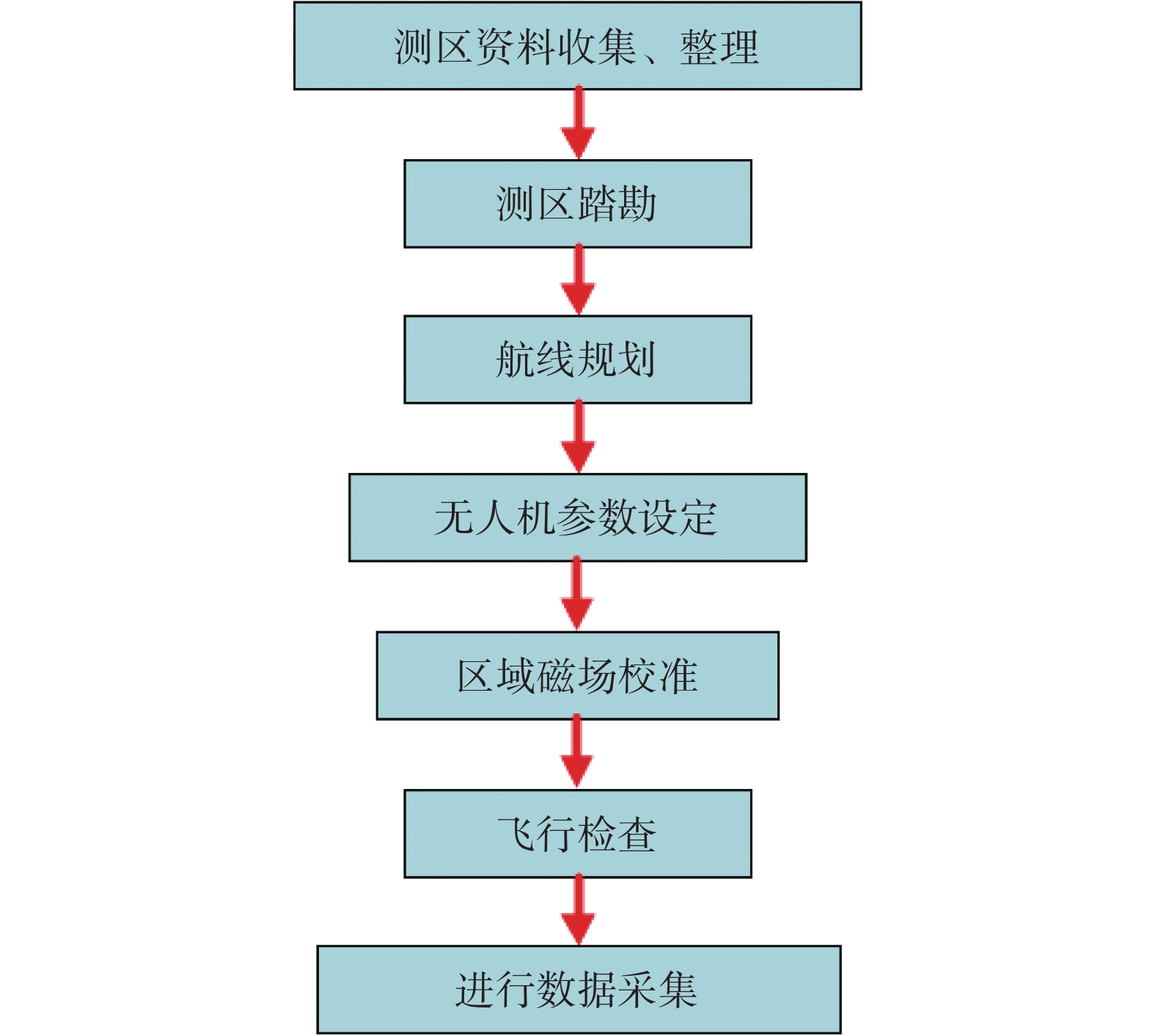
根据项目实际,总结了免像控无人机数据采集流程,具体包括测区资料收集整理、测区踏勘、航线规划、无人机参数设定、区域磁场校准、飞行检查和数据采集等七部分内容。传统的无人机航测技术,为达到高精度无人机数据的采集,在测区踏勘之后航线规划之前,需进行像控点野外布设和采集,用于航测数据处理和精度验证;免像控无人机航测,根据图1流程进行数据采集工作。
1.3 免像控无人机数据处理流程
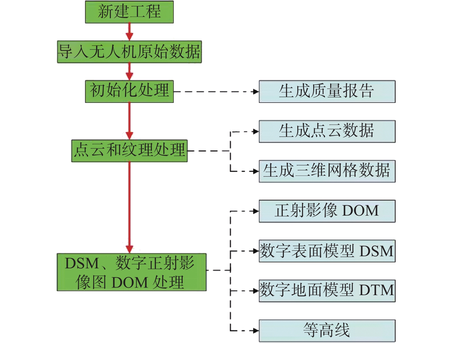
本研究基于Pix4Dmapper软件进行免相控无人机低空摄影测量数据处理,处理流程如图2所示。
Pix4Dmapper软件是瑞士全自动无人机数据处理软件,根据不同的模块可完成不同的业务需求。Pix4Dmapper具有优越的处理算法、高度集成的业务模块、简洁的处理流程,支持类型多样的传感器,可将多架次、多航摄条件的数据整合并行处理,通过参数设定,完成空三加密、三维格网数据生成、数字地表模型DSM、数字正射影像图DOM等数据的生产,目前已涉及测绘成图、灾害监测、环境监测、电力巡线、辅助执法等众多领域[33-37]。
利用 Pix4Dmapper 对免像控无人机航测数据进行处理,不需刺入地面像控点。无人机数据处理流程包括新建工程、导入无人机航测原始数据、初始化处理、点云和纹理处理、数字表面模型DSM及正射影像DOM处理。第一步,新建项目工程,索引及存放当前所有的处理数据;第二步,导入无人机航测原始数据,需设定空间参考坐标系;第三步,初始化处理,航测数据导入后,进行影像匹配、空三解算等流程,得到初始化处理数据和质量报告;第四步,点云和纹理处理,设定点云和三维格网参数,进行相关处理;最后,数字表面模型DSM、正射影像DOM处理,根据软件集成算法,进行影像匀色匀光、正射纠正及自动镶嵌,生成数字正射影像DOM、数字地面模型DTM、数字高程模型DEM等成果。
2. 舟曲立节北山滑坡-泥石流灾害
2.1 滑坡-泥石流灾害概况
立节北山滑坡处于舟曲县西部、白龙江上游左岸的立节镇北侧,距舟曲县城36 km,S313线自坡脚南侧通过(图3)。立节镇北山滑坡处于长期蠕动状态,历史上多次发生滑坡-泥石流链式灾害。据调查,40多年以来,滑坡曾于1978年、1992年、2010年、2018年多次复活滑动,并引发泥石流灾害,造成严重的灾情。尤以1978年最为严重,致使滑坡体上部100多户居民房屋损毁,被迫搬迁至立节镇。2020年8月以来,舟曲县立节北山老滑坡部分复活,造成北山村通村道路局部塌陷,滑坡处于不稳定状态,可能以滑坡-泥石流灾害链模式致灾,直接威胁滑坡体上部村落及沟口堆积扇镇驻地,威胁财产巨大、人数众多,险情等级为特大型。
2.2 地质环境背景
滑坡区属北亚热带向北温带的过渡区,南侧坡脚白龙江自西向东穿过,地形北高南低,山体呈向南侧开口的“V”型不规则弧状展布,坡顶海拔3750 m,坡脚白龙江河谷海拔1510 m,高差2240 m,坡度30°~50°。区内地貌类型主要为侵蚀堆积河谷、侵蚀构造中山和侵蚀构造高山。滑坡体上部出露第四系上更新统马兰黄土,中部为中泥盆灰岩及千枚岩,下部为中、上志留统板岩、千枚岩,表层为第四系全新统次生黄土、碎石层、坡积碎石层和滑坡堆积碎石土等。滑坡处于白龙江复背斜及白龙江断裂带影响区,岩土体裂隙极为发育,受白龙江断裂南支断层控制,滑坡垂直于断层走向发育。区内地下水类型主要为岩溶裂隙水和松散岩类孔隙水两大类,岩溶裂隙水赋存于泥盆系灰岩构造和风化裂隙内,主要接受大气降水补给;松散岩类孔隙水又可细分为滑坡堆积体孔隙水和河谷松散岩类孔隙水。
2.3 发育特征
2.3.1 滑坡发育特征
(1)基本特征
舟曲县立节镇北山滑坡为一老滑坡体(H),体积约4.20×10⁶ m3,属大型黄土碎石土混合土质滑坡。本次滑坡为老滑坡的部分复活,按照发育特征可分为HI滑坡、HII滑坡。滑坡平面形态为舌状,剖面呈折线形,体积约2.70×10⁶ m3,规模为大型。复活体高悬于山坡上,后缘呈圈椅状,前缘剪出口明显。滑体成分为黄土和碎石土混杂堆积体,滑床为板岩、千枚岩强风化破碎层。
(2)变形特征
滑坡体变形特征明显,主要表现为坡体裂缝发育数十条,裂缝长20~150 m,宽5~30 cm,局部有错动陡坎,高差5~20 cm;坡腰道路错断塌落,坡脚路面出现裂缝;中部既有框架下部平台已出现多次次级滑动,导致局部框架基础滑动后外露,框架基础两侧未滑动部分均已出现贯穿的裂缝;滑坡中下部醉汉林成片分布,局部时有碎石土下溜;东侧冲沟两侧已发生多起滑塌。
2.3.2 泥石流发育特征
(1)形成条件
立节北山泥石流形成与立节北山滑坡密切相关,属于由高位滑坡转化形成的沟谷型泥石流。泥石流流域地形起伏较大,地势较为陡峻,为泥石流提供了有利的地形条件。丰富的松散固体物质是立节北山泥石流形成最基本的条件,物质来源形式主要有滑坡、崩塌、坡面补给和沟道堆积再搬运四类,其中以北山滑坡堆积物占主导地位。近年来,立节镇年降水量逐年增多,区内降水集中在6−9月,且多以强降雨出现,具有降水集中、雨强大的特点,短历时大强度的降水为泥石流的形成提供了充足的水源条件,是区内泥石流频发的重要原因。
(2)分区特征
立节北山泥石流沟为典型的滑坡转化为泥石流的链式灾害,属于高频黏性中型沟谷泥石流,汇水区、形成区、流通区、堆积区较为明显。滑坡所在坡体顶部基岩山区为泥石流汇水区,平面呈不规则三角形,面积0.35 km2,占流域面积的22%。水流途径坡体中部立节北山滑坡时,大量的松散物质为坡体4条冲沟提供了丰富的物质来源,为泥石流形成区,面积0.87 km2,占流域面积的56%,形成区总体地形为上部缓下部陡。在坡脚段,4条冲沟呈“梳”状在狭窄的沟槽排列并最终汇集形成泥石流流通区,面积0.11 km2,占流域面积的7%,冲沟内滑坡堆积物松散滑落至流通区上游,堵塞沟道或覆盖在沟道内,在强降雨中进入流通区形成泥石流,流通区中下段弯曲处沟槽爬高痕迹最高可达10 m。经流通区后泥石流在沟口段减速堆积,形成堆积扇,面积0.22 km2,占流域面积的14%,扇形地较为完整,长度450 m,宽700 m,扩散角100°,坡度10°~15°,为耕地和镇政府所在地。
3. 舟曲立节北山滑坡-泥石流灾害免像控无人机航测应用
3.1 数据获取及精度分析
在满足大比例精度测量和快速获取数据的要求前提下,利用Phantom 4 RTK无人机进行数据采集,该无人机建图精度优于1∶500地形图航空摄影测量内业规范的精度要求,单次飞行最大作业面积可达1 km2。文中利用免像控无人机航测技术获取了舟曲县立节北山滑坡-泥石流灾害基础测绘数据,并选取泥石流沟道区域进行航测精度分析。
3.1.1 数据采集
作业区域后部为立节北山山体部分,相对高差较大,为保证数据质量,采用分层数据获取的方法。进行现场踏勘,排除高电磁辐射、高耸地表构筑物产生的限制;根据气象条件因素,满足数据采集飞行环境条件;结合地形条件,设定航向和旁向重叠度均为80%,综合利用免像控无人机获取数据流程(图1)进行数据获取操作。
飞行航线规划设计以快速获取灾害链沟道沟口测量数据为目的,选取测区中上部为起飞点,结合实地地形因素,综合规划航线如图4所示,为评定测量精度,实地布设像控点作为检核点,使用华测RTK移动站,获取检核点空间坐标数据。选取合适飞行高度和航线重叠度,获取航摄相片数268张。
本次使用Pix4Dmapper 软件进行航测数据处理,不需过多人工干涉,只需设定步骤所需参数,即生成DOM正射影像、DTM数据、DSM数据等。质量报告显示本次处理航测分辨率GSD为6.55 cm,耗时约4.5 h,数据处理质量均为最佳。
3.1.2 结果与数据分析
探究免像控无人机航测技术在突发性地质灾害应急处置中精度可行性,均匀选取泥石流沟道及附近28个特征明显的地面检核点,包括油漆喷绘、建筑物角点等,空间位置分布见图4,使用华测RTK移动测站获取检核点空间坐标,成果点位平面坐标由DOM正射影像获取,高程值则利用具有空间位置的数字表面模型DSM进行ArcGIS软件提取至点获取,并剔除异常检测点gd14,进行空间坐标点位较差计算。
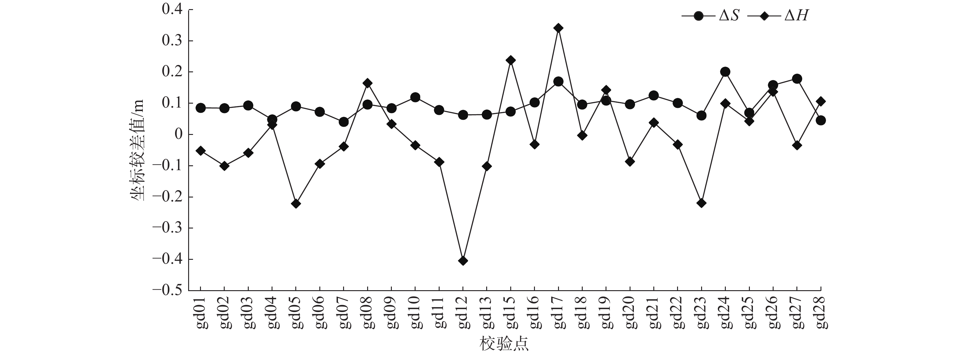
利用平面和高程方向较差数据绘制平面及高程方向较差图(图5),其中ΔS表示检核点平面方向与成果量测坐标较差值,ΔH表示检核点垂直方向与成果量测坐标较差值,由图5可知,同名检核点在ΔS和ΔH数据分布上并未出现较强的规律性;ΔX表示检核点横轴方向与成果量测坐标横轴较差值,ΔY表示检核点纵轴方向与成果量测坐标纵轴较差值,ΔX和ΔY在误差空间分布上具有较强的一致性,且平面方向ΔS随ΔX和ΔY的变化而变化。
对平面方向和垂直方向的点位坐标较差进行折线图绘制(图6)。平面方向坐标较差值较为稳定,数据在0.1 m左右摆动,垂直方向较差值波动性偏大,主要表现在gd12、gd15、gd17和gd23检核点较差值较大,经现场检查验证,影响精度的主要因素为:检核点点位在航测图像上存在投影差,且与航摄相片质量关系较大。
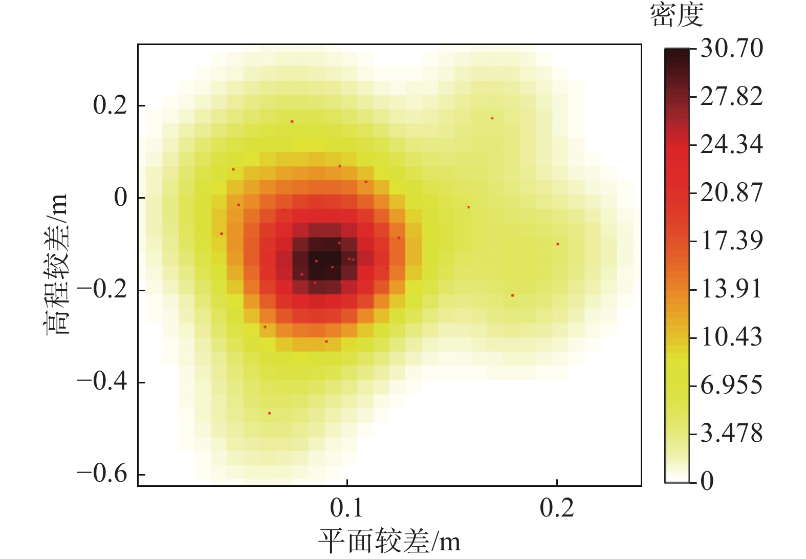
根据平面较差ΔS和高程较差ΔH绘制2D核密度分布,图7数据显示,高程方向误差主要集中在±0.3之间,平面方向误差主要集中在0.05~0.15 m,总体而言,免像控无人机航测技术获取的数据误差较小,误差主要受地形、飞行姿态、相片质量等因素的影响。
结果分析:测区平面较差绝对值的最大值为0.201 m,平面中误差为±0.104 m,高程较差绝对值的最大值为0.467 m,高程中误差为±0.171 m,满足《低空数字航空摄影测量内业规范》(GH/Z 3003—2010)技术规范要求。本实例显示免像控无人机航测技术获取的平面及高程数据均具有较高的精度,误差主要体现在高程方向,由于测区为山区,地形起伏大,易造成像片倾斜和地形起伏引起的像点位移,同时,飞行姿态和相片质量也是影响精度的主要因素。
3.2 滑坡区特征提取
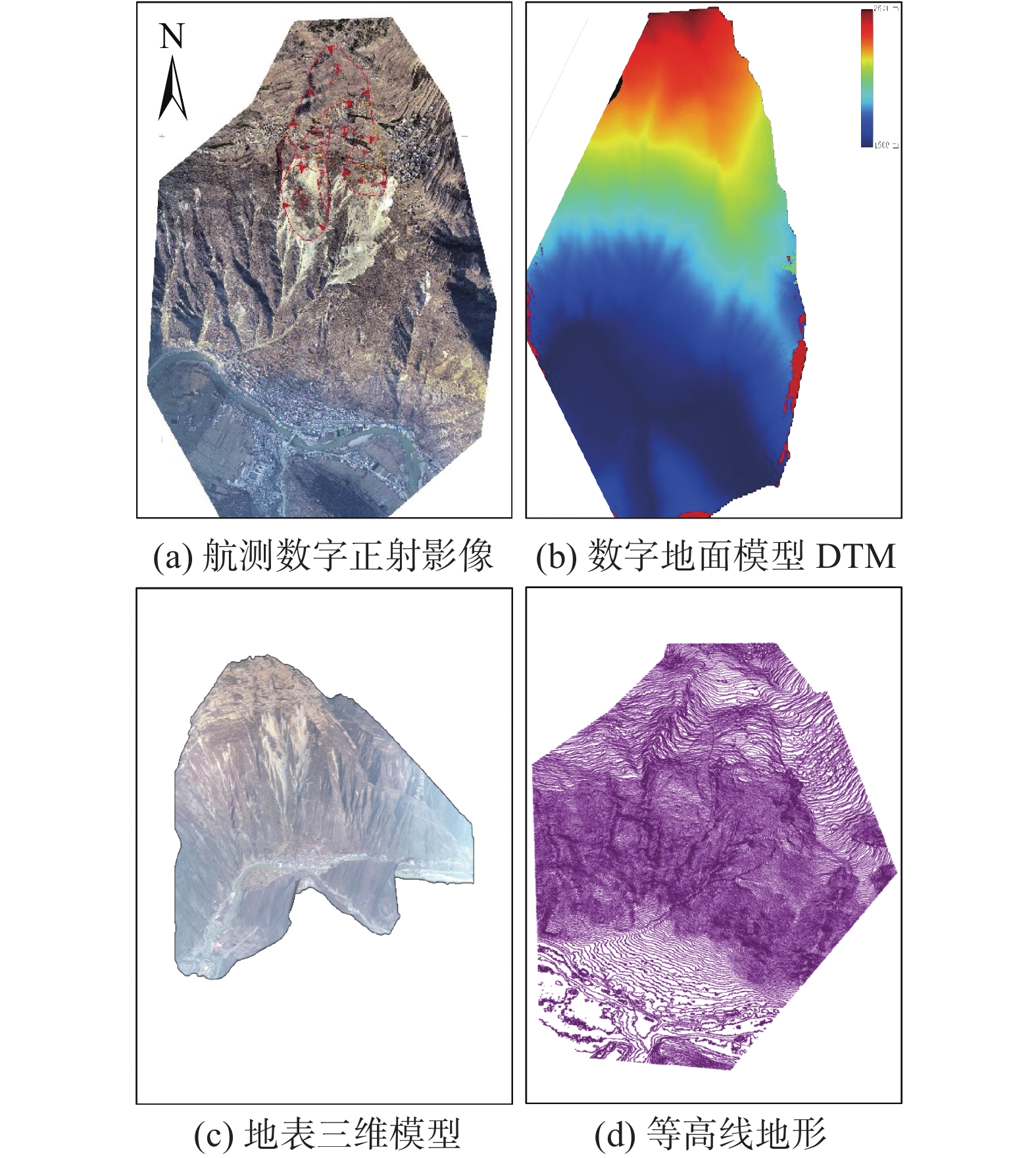
滑坡区位于研究区后缘,是灾害链主要物源区域,根据免像控无人机航测数据采集及处理要求,获取该区域无人机航测成果数据(图8),结合实际调查分析灾害区相关特征(图9),利用GIS软件确定灾害区空间几何参数。
舟曲县立节镇北山滑坡为一老滑坡体(H),平面形态为舌状,滑坡长600~1200 m(平均长750 m),宽260~520 m(平均宽430 m),面积约32.3×10⁴ m2,后缘高程2520 m,前缘高程1921 m,相对高差599 m,剪出口-江水平距离848 m,垂直高差408 m。HI滑坡平面形态呈不规则状,长500~700 m(平均长550m),宽度300~500 m(平均宽420 m),面积约22.6×10⁴ m2,后缘高程2431 m,前缘高程1921 m,相对高差510 m,剪出口-江水平距离为848 m,垂直高差408 m。根据滑坡体的地貌特征和变形特征,可将滑坡分为三个次级滑坡(HI1、HI2、HI3)。其中:HI1滑坡位于HI滑坡中后部,滑体较完整,形态呈不规则形状,坡度较为平缓;HI2滑坡、HI3滑坡均位于HI滑坡中下部,两个滑坡之间受山梁阻隔,将其切割成两个独立的块体。HII滑坡位于HI滑坡东侧,平面形态为舌状,滑坡长度约90 m,宽约155 m,面积约1.4×10⁴ m2,后缘高程2282 m,前缘高程2178 m,相对高差104 m,剪出口-江水平距离为1213 m,垂直高差665 m(图9)。
利用无人机航测正射影像解译裂缝发育状况,HI1滑坡后缘裂缝贯穿长约30 m;前缘变形明显,裂缝长约6 m,宽约30 cm;HI2滑坡后缘发育一道贯穿裂缝,长约150 m,滑坡下部次级滑坡发育,裂缝发育数十条;滑坡中部既有框架基础两侧未滑动部分均已出现贯穿的裂缝,裂缝长约70 m,其中东侧裂缝长约30 m,西侧裂缝长约40 m;HI3滑坡后缘裂缝发育,裂缝长约20 m;坡体西侧前缘裂缝发育,长约50 m。通过实地调查验证,无人机航测成果解译裂缝与实地相符。
3.3 泥石流沟道特征提取
研究区后部滑坡物源为泥石流的发生提供了物质条件,加之高陡地形利于物源势能释放,在水的作用下易形成泥石流,对沟道处人民生命财产安全构成威胁。经航测成果解译,泥石流流域呈北南向展布,总体呈“桃叶状”,流域面积1.55 km2,含主沟1条、支沟4条。主沟长约2580 m,深度5~8 m,底宽一般小于15 m,比降530‰。4条支沟呈“梳”状在狭窄的沟槽排列并最终汇集形成泥石流流通区,面积0.11 km2;支沟1长约400 m,深度约2~8 m,宽6~10 m,比降可达650‰,支沟2长约110 m,深度约2~6 m,宽4~6 m,比降可达427‰。支沟3长约505 m,深度约2~8 m,宽1~6 m,比降可达596‰;支沟4长约550 m,深度约3~8 m,宽5~8 m,比降可达620‰。通过实地验证,沟道平面数据与实际相符。
4. 结论
舟曲县立节北山滑坡-泥石流灾害应急处置中采用免像控无人机航测技术,快速获取了灾害区域基础测绘数据,为地质灾害应急处置节约了时间成本,在满足精度的前提下,能够快速确定灾害体几何参数,预估体积方量,评估灾情、险情严重程度以及次生灾害的影响,能够有效保障人民群众生命财产安全。文中根据免像控无人机航测技术在应急处置中的实际应用得出如下结论:
(1)测区平面较差绝对值的最大值为0.201 m,平面中误差为±0.104 m,高程较差绝对值的最大值为0.467 m,高程中误差为±0.171 m,满足《低空数字航空摄影测量内业规范》(GH/Z 3003—2010)技术规范要求。
(2)根据免像控无人机航测成果获取滑坡区几何参数,滑坡区为一老滑坡体(H),滑坡长600~1200 m(平均长750 m),宽260~520 m(平均宽430 m),面积约32.3×10⁴ m2。HI滑坡长500~700 m(平均长550 m),宽度300~500 m(平均宽420 m),面积约22.6×10⁴ m2。HII滑坡长度约90 m,宽约155 m,面积约1.4×10⁴m2。
(3)根据航测成果影像数据进行解译,滑坡整体平面形态为舌状,后缘呈圈椅状,前缘滑坡剪出口位置明显。
(4)结合无人机航测数字高程模型数据、三维模型数据获取滑坡空间参数,老滑坡体(H)前后缘相对高差约599 m,滑坡底端到江距离848 m,HI滑坡前后缘相对高差约510 m,滑坡底端到江距离848 m,HII滑坡前后缘相对高差约104 m,滑坡底端到江距离1213 m。
(5)根据免像控无人机航测成果获取泥石流沟道相关参数,泥石流沟道有主沟1条、支沟4条。主沟长约2580 m,深度5~8 m,底宽一般小于15 m,比降530‰。4条支沟呈“梳”状在狭窄的沟槽排列并最终汇集形成泥石流流通区,面积0.11 km2;支沟长约100~600 m,深度约2~8 m,宽1~8 m,平均比降为570‰。
(6)免像控无人机航测技术能够快速获取了灾害区域基础数据。免像控无人机航测技术与传统航测技术相比,外业工作减少了像控点的布设与采集,内业处理减少了人工干预,节约了航测数据采集与处理的时间,有效保障了地质灾害应急处置的时效性。
-
[1] 陈文君, 陈锁忠, 张磊, 等. 突发性地质灾害应急处置系统的设计与实现[J]. 计算机应用与软件,2014,31(5):6 − 9. [CHEN Wenjun, CHEN Suozhong, ZHANG Lei, et al. Design and implementation of an emergency disposition system on sudden geological disasters[J]. Computer Applications and Software,2014,31(5):6 − 9. (in Chinese with English abstract) DOI: 10.3969/j.issn.1000-386x.2014.05.002 [2] 刘传正. 重大突发地质灾害应急处置的基本问题[J]. 自然灾害学报,2006,15(3):24 − 30. [LIU Chuanzheng. Basic problem on emergency disposition of abrupt heavy geological disaster[J]. Journal of Natural Disasters,2006,15(3):24 − 30. (in Chinese with English abstract) DOI: 10.3969/j.issn.1004-4574.2006.03.005 [3] 刘传正, 陈红旗, 韩冰, 等. 重大地质灾害应急响应技术支撑体系研究[J]. 地质通报,2010,29(1):147 − 156. [LIU Chuanzheng, CHEN Hongqi, HAN Bing, et al. Technical support system of emergency response for serious geo-hazards[J]. Geological Bulletin of China,2010,29(1):147 − 156. (in Chinese with English abstract) [4] 陈红旗, 徐永强, 庄茂国, 等. 地质灾害应急支撑体系建设基本问题分析[J]. 中国地质灾害与防治学报,2011,22(4):108 − 111. [CHEN Hongqi, XU Yongqiang, ZHUANG Maoguo, et al. Study on the construction of geological disaster emergency support system[J]. The Chinese Journal of Geological Hazard and Control,2011,22(4):108 − 111. (in Chinese with English abstract) DOI: 10.3969/j.issn.1003-8035.2011.04.023 [5] 李俊峰, 张小趁, 刘红岩, 等. 突发地质灾害应急数值模拟浅析[J]. 中国地质灾害与防治学报,2016,27(2):154 − 161. [LI Junfeng, ZHANG Xiao chen, LIU Hongyan, et al. Numerical simulation technology analysis of geological disaster emergency[J]. The Chinese Journal of Geological Hazard and Control,2016,27(2):154 − 161. (in Chinese with English abstract) [6] CHOU T Y, YE M L, CHEN Y C, et al. Disaster monitoring and management by the unmanned aerial vehicle technology[J]. International archives of the photogrammetry, remote sensing and spatial information sciences,2010,38(7B):137 − 142.
[7] DOMINICI, ALICANDRO, MASSIMI V. UAV photogrammetry in the post-earthquake scenario: Case studies in L'Aquila[J]. Geomatics Natural Hazards and Risk,2017,8(1):87 − 103.
[8] SALVINI R, MASTROROCCO G, SEDDAIU M, et al. The use of an unmanned aerial vehicle for fracture mapping within a marble quarry (Carrara, Italy): Photogrammetry and discrete fracture network modelling[J]. Geomatics Natural Hazards & Risk,2017,8(1):34 − 52.
[9] 曾涛, 杨武年, 简季. 无人机低空遥感影像处理在汶川地震地质灾害信息快速勘测中的应用[J]. 测绘科学,2009,34(增刊 2):64 − 65. [ZENG Tao, YANG Wunian, JIAN Ji. Applications of remote sensing images processing of unmanned air vehicle on the low attitude in quick acquirement of geological disasters information in Wenchuan earthquake[J]. Science of Surveying and Mapping,2009,34(Sup 2):64 − 65. (in Chinese with English abstract) [10] 高姣姣, 颜宇森, 盛新蒲, 等. 无人机遥感在西气东输管道地质灾害调查中的应用[J]. 水文地质工程地质,2010,37(6):126 − 129. [GAO Jiaojiao, YAN Yusen, SHENG Xinpu, et al. Application of UAV remote sensing in Geologic hazards survey along the project of west-east gas transmission[J]. Hydrogeology & Engineering Geology,2010,37(6):126 − 129. (in Chinese with English abstract) DOI: 10.3969/j.issn.1000-3665.2010.06.025 [11] 朱婵莲, 姜啸, 焦龙进. 无人机在地质灾害应急抢险调查中的应用[J]. 中国金属通报,2020(6):184 − 185. [ZHU Chanlian, JIANG Xiao, JIAO Longjin. Application of UAV in geological disaster emergency investigation[J]. China Metal Bulletin,2020(6):184 − 185. (in Chinese with English abstract) [12] 郭晨, 许强, 彭双麒, 等. 无人机摄影测量技术在金沙江白格滑坡应急抢险中的应用[J]. 灾害学,2020,35(1):203 − 210. [GUO Chen, XU Qiang, PENG Shuangqi, et al. Application research of UAV photogrammetry technology in the emergency rescue of Baige landslide[J]. Journal of Catastrophology,2020,35(1):203 − 210. (in Chinese with English abstract) DOI: 10.3969/j.issn.1000-811X.2020.01.038 [13] 李晓俊, 朱钱洪, 胡勇, 等. 多旋翼无人机山区城市地质灾害应急响应能力评估[J]. 地理空间信息,2019,17(3):12 − 15. [LI Xiaojun, ZHU Qianhong, HU Yong, et al. Geological disaster emergency response capability assessment of multirotor UAV in mountain city[J]. Geospatial information,2019,17(3):12 − 15. (in Chinese with English abstract) DOI: 10.3969/j.issn.1672-4623.2019.03.004 [14] 叶伟林, 宿星, 魏万鸿, 等. 无人机航测系统在滑坡应急中的应用[J]. 测绘通报,2017(9):70 − 74. [YE Weilin, SU Xing, WEI Wanhong, et al. Application of UAV aerial photograph system in emergency rescue and relief for landslide[J]. Bulletin of Surveying and Mapping,2017(9):70 − 74. (in Chinese with English abstract) [15] 董秀军, 王栋, 冯涛. 无人机数字摄影测量技术在滑坡灾害调查中的应用研究[J]. 地质灾害与环境保护,2019,30(3):78 − 85. [DONG Xiujun, WANG Dong, FENG Tao. Research on the application of unmanned aerial vehicle digital photogrammetry in landslide disaster investigation[J]. Journal of Geological Hazards and Environment Preservation,2019,30(3):78 − 85. (in Chinese with English abstract) [16] 吴振宇, 马彦山. 无人机遥感技术在地质灾害调查中的应用[J]. 宁夏工程技术,2012,11(2):133 − 136. [WU Zhenyu, MA Yanshan. Application of remote sensing technology of UAV in the investigation of the geological disaster[J]. Ningxia Engineering Technology,2012,11(2):133 − 136. (in Chinese with English abstract) DOI: 10.3969/j.issn.1671-7244.2012.02.010 [17] 崔红霞, 林宗坚, 孙杰. 无人机遥感监测系统研究[J]. 测绘通报,2005(5):11 − 14. [CUI Hongxia, LIN Zongjian, SUN Jie. Research on UAV remote sensing system[J]. Bulletin of Surveying and Mapping,2005(5):11 − 14. (in Chinese with English abstract) DOI: 10.3969/j.issn.0494-0911.2005.05.003 [18] 晏磊, 吕书强, 赵红颖, 等. 无人机航空遥感系统关键技术研究[J]. 武汉大学学报(工学版),2004,37(6):67 − 70. [YAN Lei, LYU Shuqiang, ZHAO Hongying, et al. Research on key techniques of aerial remote sensing system for unmanned aerial vehicles[J]. Engineering Journal of Wuhan University,2004,37(6):67 − 70. (in Chinese with English abstract) [19] 雷添杰, 李长春, 何孝莹. 无人机航空遥感系统在灾害应急救援中的应用[J]. 自然灾害学报,2011,20(1):178 − 183. [LEI Tianjie, LI Changchun, HE Xiaoying. Application of aerial remote sensing of pilotless aircraft to disaster emergency rescue[J]. Journal of Natural Disasters,2011,20(1):178 − 183. (in Chinese with English abstract) [20] 马泽忠, 王福海, 刘智华, 等. 低空无人飞行器遥感技术在重庆城口滑坡堰塞湖灾害监测中的应用研究[J]. 水土保持学报,2011,25(1):253 − 256. [MA Zezhong, WANG Fuhai, LIU Zhihua, et al. Research of unmanned aerial vehicle remote sensing technique applied to monitor landslip and barrier lake hazard in Chengkou County of Chongqing[J]. Journal of Soil and Water Conservation,2011,25(1):253 − 256. (in Chinese with English abstract) [21] 尹鹏飞, 尹球, 陈兴峰, 等. 无人机航空遥感技术在震后灾情调查中的应用[J]. 激光与光电子学进展,2010,47(11):130 − 134. [YIN Pengfei, YIN Qiu, CHEN Xingfeng, et al. Unmanned aerial vehicle aerial remote sensing techniques and its application on post-earthquake disaster investigation[J]. Laser & Optoelectronics Progress,2010,47(11):130 − 134. (in Chinese with English abstract) [22] 韩文权, 任幼蓉, 赵少华. 无人机遥感在应对地质灾害中的主要应用[J]. 地理空间信息,2011,9(5):6 − 8. [HAN Wenquan, REN Yourong, ZHAO Shaohua. Primary usages of UAV remote sensing in geological disaster monitoring and rescuing[J]. Geoscience Information,2011,9(5):6 − 8. (in Chinese with English abstract) [23] 刘刚, 徐宏健, 马海涛, 等. 无人机航测系统在应急服务保障中的应用与前景[J]. 测绘与空间地理信息,2011,34(4):177 − 179. [LIU Gang, XU Hongjian, MA Haitao, et al. Unmanned aerial system applications and prospects in the protection of emergency services[J]. Geomatics & Spatial Information Technology,2011,34(4):177 − 179. (in Chinese with English abstract) DOI: 10.3969/j.issn.1672-5867.2011.04.057 [24] 肖波, 朱兰艳, 黎剑, 等. 无人机低空摄影测量系统在地质灾害应急中的应用研究:以云南洱源特大山洪泥石流为例[J]. 价值工程,2013,32(4):281 − 282. [XIAO Bo, ZHU Lanyan, LI Jian, et al. Application of unmanned aerial vehicle photogram metric system in geological disaster: A case study in Er yuan devastating mudslides of Yunnan Province[J]. Value Engineering,2013,32(4):281 − 282. (in Chinese with English abstract) DOI: 10.3969/j.issn.1006-4311.2013.04.155 [25] 嵇沛, 胡一凡, 王晨. 无人机低空航拍遥感在应急测绘保障中的应用[J]. 科技资讯,2016,14(24):2 − 3. [JI Pei, HU Yifan, WANG Chen. Application of UAV low altitude aerial remote sensing in emergency surveying and mapping support[J]. Science & Technology Information,2016,14(24):2 − 3. (in Chinese with English abstract) [26] 田彦. 无人机遥感技术在地质环境灾害监测中的应用探讨[J]. 环境与发展,2019,31(4):102 − 104. [TIAN Yan. Application of UAV remote sensing technology in geological environmental disaster monitoring[J]. Environment and Development,2019,31(4):102 − 104. (in Chinese with English abstract) [27] 周嵩. 无人机技术在地质灾害防治中的应用[J]. 冶金管理,2020(21):87 − 88. [ZHOU Song. Application of UAV technology in geological disaster prevention and control[J]. Metallurgical Management,2020(21):87 − 88. (in Chinese with English abstract) [28] 郭晨, 许强, 董秀军, 等. 无人机在重大地质灾害应急调查中的应用[J]. 测绘通报,2020(10):6 − 11. [GUO Chen, XU Qiang, DONG Xiujun, et al. Application of UAV photogrammetry technology in the emergency rescue of catastrophic geohazards[J]. Bulletin of Surveying and Mapping,2020(10):6 − 11. (in Chinese with English abstract) [29] 张允涛. 免相控无人机航摄系统在棚户区改造1∶500地形图中的应用[J]. 测绘通报,2019(增刊 1):295 − 297. [ZHANG Yuntao. Application of phase-free UAV aerial photography system in 1∶500 topographic map of shantytown reconstruction[J]. Bulletin of Surveying and Mapping,2019(Sup 1):295 − 297. (in Chinese with English abstract) [30] 石鼎. 免像控无人机在地形图测绘中的应用[J]. 北京测绘,2020,34(2):163 − 166. [SHI Ding. Application of UAV image free control in topographic map surveying[J]. Beijing Surveying and Mapping,2020,34(2):163 − 166. (in Chinese with English abstract) [31] 朱晓康, 魏景帅. 1∶500免像控无人机航测技术应用研究[J]. 地理空间信息,2019,17(2):22 − 26. [ZHU Xiaokang, WEI Jingshuai. Key technologies and application research on 1∶500 unmanned aerial vehicle photography without image control point[J]. Geospatial Information,2019,17(2):22 − 26. (in Chinese with English abstract) DOI: 10.3969/j.issn.1672-4623.2019.02.006 [32] 范秀庆. 无人机免像控技术在地形图测量中的应用研究[J]. 测绘通报,2017(增刊 1):66 − 68. [FAN Xiuqing. Application of UAV image free control technique in topographic map surveying[J]. Bulletin Surveying and Mapping,2017(Sup 1):66 − 68. (in Chinese with English abstract) [33] 相涛, 栾元重, 许章平, 等. 基于Pix4Dmapper的无人机低空摄影测量数据处理[J]. 测绘与空间地理信息,2019,42(3):75 − 78. [XIANG Tao, LUAN Yuanzhong, XU Zhangping, et al. Unmanned aerial vehicle with low-altitude aerial photogrammetry data processing flow and precision analysis based on Pix4Dmapper[J]. Geomatics & Spatial Information Technology,2019,42(3):75 − 78. (in Chinese with English abstract) [34] 戴嵩, 魏冠军, 梁斌. 控制点布设方案对无人机精度测量的影响及其应用[J]. 中国地质灾害与防治学报,2021,32(5):113 − 120. [DAI Song, WEI Guanjun, LIANG Bin. Influence of control point number on UAV low-altitude photogrammetry and its application: A case study in subsidence monitoring of a tailing dam area in northwestern China[J]. The Chinese Journal of Geological Hazard and Control,2021,32(5):113 − 120. (in Chinese with English abstract) [35] 贾虎军, 王立娟, 范冬丽. 无人机载LiDAR和倾斜摄影技术在地质灾害隐患早期识别中的应用[J]. 中国地质灾害与防治学报,2021,32(2):60 − 65. [JIA Hujun, WANG Lijuan, FAN Dongli. The application of UAV LiDAR and tilt photography in the early identification of geo-hazards[J]. The Chinese Journal of Geological Hazard and Control,2021,32(2):60 − 65. (in Chinese with English abstract) [36] 张欢, 巨能攀, 陆渊, 等. 基于无人机的滑坡地形快速重建与稳定性分析[J]. 水文地质工程地质,2021,48(6):171 − 179. [ZHANG Huan, JU Nengpan, LU Yuan, et al. Rapid remodeling of three-dimensional terrain and stability analyses of landslide based on UAV[J]. Hydrogeology & Engineering Geology,2021,48(6):171 − 179. (in Chinese with English abstract) [37] 文宝萍, 王凡. 1965年烂泥沟滑坡前兆、高速远程运动及后期演化特征[J]. 水文地质工程地质,2021,48(6):72 − 80. [WEN Baoping, WANG Fan. Precursors and motion characteristics of the 1965 Lannigou rockslides and the subsequent evolution[J]. Hydrogeology & Engineering Geology,2021,48(6):72 − 80. (in Chinese with English abstract) -
期刊类型引用(18)
1. 黄荣. 无人机倾斜摄影测量技术在地灾监测中的应用. 地下水. 2024(02): 179-181+267 .  百度学术
百度学术
2. 黄明. 滑坡地质灾害应急处置技术研究以及防治措施分析. 工程建设与设计. 2024(09): 40-42 .  百度学术
百度学术
3. 宁剑波. 无人机免像控技术在带状地形测量中的应用. 科学技术创新. 2024(14): 18-22 .  百度学术
百度学术
4. 何雨健,窦杰,王协康,付永虎,马豪,汪恒. 国内外免像控无人机航测软件在数字滑坡中的应用效果对比——以三峡库区黄土坡滑坡为例. 中国地质灾害与防治学报. 2024(05): 160-173 .  本站查看
本站查看
5. 颜循英. 无人机航测技术在新农村建设中的应用初探. 南方农机. 2023(03): 158-160 .  百度学术
百度学术
6. 徐汉超,蔡雨寒. 辽宁省应急测绘系统中高寒型无人机的应用. 水利技术监督. 2023(01): 45-47+63 .  百度学术
百度学术
7. 向籽佺,刘峰,唐雨婷,王江海,赖佳鑫,张苧尹,刘英. 差异化乡村振兴路径下村域土地利用变化特征及其驱动归因——以重庆市江津区两个村为例. 长江流域资源与环境. 2023(05): 973-984 .  百度学术
百度学术
8. 强德霞,苟彦梅,张军伟,王嘉. 基于实景三维模型对滑坡进行识别分析——以天水市元龙镇为例. 黑龙江科学. 2023(08): 150-152+155 .  百度学术
百度学术
9. 刘军,王磊. 基于无人机倾斜摄影的黄土滑坡调查与危险性评价. 水土保持通报. 2023(02): 139-147 .  百度学术
百度学术
10. 郭琪璇,宋晓芳,杨礼朋. 倾斜摄影测量在地质灾害调查中的应用. 山西煤炭. 2023(01): 72-77 .  百度学术
百度学术
11. 王承恩. 无人机航测技术在工程测量中的应用探索. 产业创新研究. 2023(18): 112-114 .  百度学术
百度学术
12. 韩岳麒. 遥感大数据在防灾减灾中的应用. 山西大同大学学报(社会科学版). 2023(05): 148-151 .  百度学术
百度学术
13. 钱庭青,张迁,徐洪钟,毕港,朱焕. 基于无人机摄像技术的水电工程库区国土空间快速建模及数值分析. 高校地质学报. 2023(06): 902-907 .  百度学术
百度学术
14. 贾永刚,陈天,李培英,李正辉,胡聪,刘晓磊,单红仙. 海洋地质灾害原位监测技术研究进展. 中国地质灾害与防治学报. 2022(03): 1-14 .  本站查看
本站查看
15. 邹水宝. 工程测量中无人机航测技术的应用研究. 电子元器件与信息技术. 2022(05): 17-20 .  百度学术
百度学术
16. 宋杨. 水工环地质技术在地质灾害防治工程中的运用. 世界有色金属. 2022(14): 187-189 .  百度学术
百度学术
17. 邹馨,刘健,陈晓勇. 无人机倾斜摄影在不动产测量的应用. 北京测绘. 2022(10): 1396-1401 .  百度学术
百度学术
18. 李一鸣. 城市无人机低空数字测量信息采集方法研究. 中国新技术新产品. 2022(15): 42-44 .  百度学术
百度学术
其他类型引用(5)


 下载:
下载:



 邮件订阅
邮件订阅 RSS
RSS