

Spatial-temporal distribution characteristics and influencing factors of geological disasters in the open-pit mining area of western Fushun,Liaoning Province
-
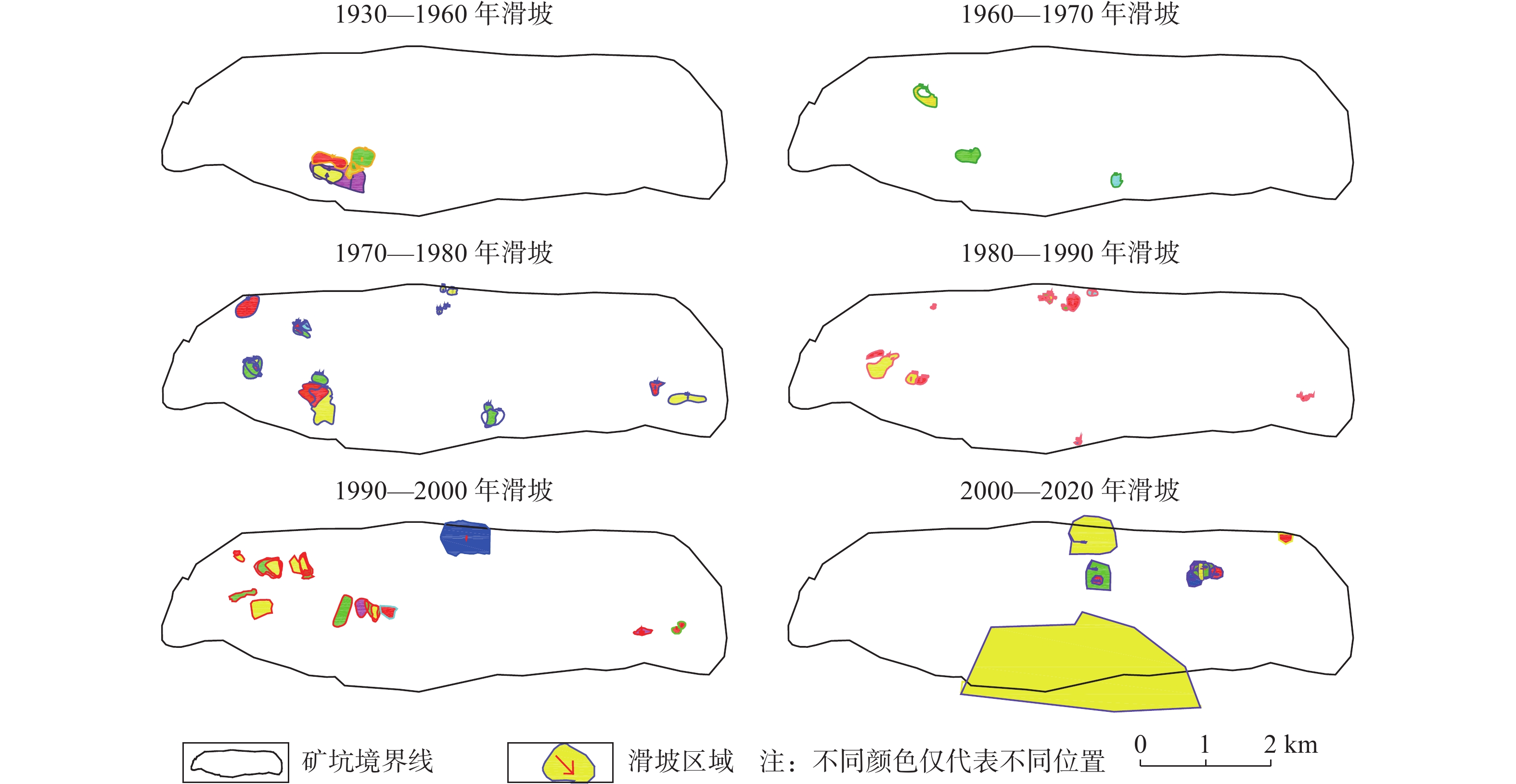
摘要: 已有百年开采历史的抚顺西露天矿进入闭坑期,由于资源的开采,导致西露天矿长期受地质灾害的威胁。为了总结西露天矿地质灾害发生规律、保障矿区及近矿城区的生产生活安全,同时为其他同类露天矿的灾害分析、安全防护提供可参考案例,从时间和空间尺度对抚顺西露天矿滑坡、地裂缝的分布规律和影响因素进行研究分析,基于DPSR模型,从驱动力响应、压力响应、状态响应三个方面提出对应的断链减灾和安全防护措施。地质灾害的时空分布特征为:滑坡灾害最早出现于1927年南帮西部,滑坡主要位置由南帮西部区域向西端帮、北帮西部、北帮中部、北帮东部方向发展,近年南帮出现大规模岩质边坡滑移变形,1970—2000年期间,滑坡灾害最为频发,2000年以后滑坡灾害频次减少,且滑坡灾害多发生在5—9月份;北帮附近地裂缝出现于1960年后,上世纪70、80年代加速发育,走向与F1、F1A断层走向基本一致,南帮地裂缝分布在南帮巨大滑移变形体后缘,呈弧扇型分布,于2009年出现,2012年后迅速发展。通过对灾害影响因素分析发现,滑坡与地裂缝存在同源性和互为因果性的链式关系,影响矿区地质灾害发生的主要因素为地质构造和不良工程地质环境控制、采矿活动驱动、降雨及地下水因素的诱发。Abstract: Fushun west open-pit mine, which has a history of 100 years of mining, entered the pit-closing period. Due to the exploitation of resources, the west open-pit mine was threatened by geological disasters for a long time. In order to summarize the occurrence regularity of geological disasters in the west open-pit mine, ensure the safety of production and life in the mining area and near-mining city, and provide reference cases for disaster analysis and safety protection of other similar open-pit mines, the distribution law and influencing factors of landslides and ground fissures in west open-pit mine are studied and analyzed from time and space scale, based on the DPSR model, the corresponding measures of chain break disaster reduction and safety protection are put forward from three aspects: driving force response, pressure response and state response. Spatial-temporal distribution characteristics of landslide: in space, it first appeared in the western part of the southern slope in 1927. In recent hundred years, due to the driving influence of open-pit mining and underground mining, the main location of landslide developed from the western part of the southern slope to the western part of the northern slope, the western part of the northern slope, the central part of the northern slope and the eastern part of the northern slope. In recent years, large-scale rock slope sliding deformation occurred in the southern slope. Actually, from 1970 to 2000, landslide disasters occurred most frequently. After 2000, the frequency of landslide disasters decreased, and most of them occurred from May to September. Spatial-temporal distribution of ground fissures: the ground fissures near the north slope appeared after 1960, and accelerated in 1970s and 1980s, with the strike basically consistent with that of F1 and F1A faults; the ground fissures in the southern slope are distributed in the rear edge of the huge slip deformation body in the southern slope, which are arc-fan shaped and appeared in 2009 and developed rapidly after 2012. Through the analysis of disaster influencing factors, it is found that there is a chain relationship of homology and mutual causality between landslides and ground fissures, and the main factors affecting the occurrence of geological disasters in mining areas are geological structure and control of unfavorable engineering geological environment, driving of mining activities and inducing of rainfall.
-
0. 引言
森林火灾是林区常见自然灾害,其不仅对生态环境质量和人类健康安全构成严重威胁,且火烧迹地在降雨条件下,极易发生泥石流灾害,这种与林火密切相关的泥石流通常被称为“火后泥石流”(post-fire debris flow)[1-3]。火烧迹地发生泥石流的概率会大幅度提高,CANNON等[4]2000年对加利福尼亚南部86个火烧迹地调查发现,约35%的火烧迹地会发生火后泥石流灾害,CANNON等[5]2001年得出约40%(37/95)的火烧迹地发生了泥石流灾害。与常规泥石流相比,火后泥石流呈现集中高频暴发[6]、降雨阈值极低[7-8]、受到火烧严重程度[9]的影响等特点[10],且起动机理也有显著区别,SANTI等[11]2008年发现火后泥石流主要由地表径流引发,GABET等[12]2008年也指出森林植物灰烬具有提高地表径流容积和运输能力的作用,任云[13]2018年基于Fuzzy-AHP建立了适用于火后泥石流的危险性评价模型。由于火后泥石流独特的发育特征与成灾机理,常规泥石流的危险性评价模型和预警避险方案适用性较差,因此建立针对火烧区火后泥石流的降雨阈值,在此基础上形成基于火后泥石流暴发降雨阈值、实时雨量监测数据与群测群防于一体的预警避险方案,对火后泥石流科学防灾具有重要意义。
1. 喜德县中坝村火烧区概况
1.1 地质环境特征
喜德县地处川西高原南段,属典型亚热带西南季风和高原气候,呈现出既有高原干燥气候、又有充沛降雨的特点。区内年平均气温约14.1 ℃,多年平均降雨量1000 mm,日最大降雨量164.3 mm。5—10月为雨季,降水过程多为强降雨、连阴雨、多夜雨,雨季降雨量占全年总降雨量的93%左右,且山区气候垂直分带十分明显,海拔每增高100 m,降雨量增加约30 mm。
发生于2020年5月7日森林火灾区位于凉山州喜德县鲁基乡中坝村一组(图1),地势北高南低,山岭海拔2050~3505 m,山区地形切割深度较浅,属构造侵蚀低中山地貌区。岩性主要为花岗岩为主,第四系全新统残坡积层主要为含块(碎)石的粉质黏土。区内因白昼以及垂直高度不同气温变化较大,地表风蚀作用强烈,岩石风化十分严重。
![]() 图 1 2020年5月7日喜德森林火灾火烧区平面示意图Figure 1. Plane diagram of forest fire and fire area in Xide County on May 7, 2020
图 1 2020年5月7日喜德森林火灾火烧区平面示意图Figure 1. Plane diagram of forest fire and fire area in Xide County on May 7, 20201.2 火烈度特征及空间分布
火烧区植被类型以云南松和常绿阔叶林为主,火灾后火烧迹地植被遭受严重破坏,覆盖率明显降低,采用多光谱遥感数据中两个波段所构建的监测指数如dNBR(the delta Normalized Burn Ratio)可以准确检算森林火烧地区的过火面积、边界及火烧程度[14-16]。本文通过Envi软件对事发地火烧前后(分别是2020年4月1日及2020年5月12日)多光谱卫星遥感图像(20 m精度)进行解译,并结合现场调查情况判断火烧面积、边界及不同区域的火烧强烈程度。火烈度遥感解译后的图像通过软件处理,可统计出火烧迹地范围内不同火烈度区面积占比,以及每条沟道流域内高烈度火烧区(中度及重度火烈度区)的面积占比。
基于PERSON等[17]提出的不同强度火烧判别特征表1,对中坝村后山火烧迹地不同火烈度区域通过遥感图像解译并结合现场实地调查,根据火烧迹地植被被烧毁程度、灰烬层厚度等特征,将火烧迹地的林火烈度分为重度、中度、轻度与未火烧四个等级。
表 1 中坝村后山火烧迹地不同强度火烈度判别特征Table 1. Distinguishing characteristics of fire intensity of different intensity in Zhongba Village burned area火强度 特点 未火烧 火烧前后地表覆盖物无变化 轻度火烧 超过50%的枯枝落叶未完全燃烧 中度火烧 大部分枯枝落叶被烧毁,但是大部分粗可燃物未完全燃烧 严重火烧 枯枝落叶和粗可燃物均被完全烧毁,地表为灰烬覆盖 根据火烈度判别标准,中坝村后山火烧迹地不同火烈度分区及相应重度、中度、轻度与未火烧区,各分区见图2、图3。
![]() 图 2 中坝村后山森林火灾火烧区不同火烈度分区图Figure 2. Zonal chart of different fire intensity in Zhongba Village forest fire area
图 2 中坝村后山森林火灾火烧区不同火烈度分区图Figure 2. Zonal chart of different fire intensity in Zhongba Village forest fire area![]() 图 3 中坝村后山森林火烧区不同火烈度部位典型照片Figure 3. Typical photos of different fire parts in the forest fire area of Zhongba Village
图 3 中坝村后山森林火烧区不同火烈度部位典型照片Figure 3. Typical photos of different fire parts in the forest fire area of Zhongba Village结果表明,中坝村后山森林火灾总过火面积约6.7 km2,其中重度火烧区占比65.93%、中度火烧区占比19.76%、轻度火烧区占比14.31%,中坝村后山1#~4#沟流域内中度及重度火烧区面积占比均超过90%(表2)。
表 2 中坝村森林火烧区不同火烈度面积占比数据统计Table 2. Statistics on the proportion of different fire intensity areas in the forest fire area of Zhongba Village/% 火烧区 轻度火烈度区面积占比 中度火烈度区面积占比 重度火烈度区面积占比 中度及重度火烈度区面积占比 整个火烧迹地 14.31 19.76 65.93 85.69 1#沟 2.11 26.56 69.41 95.97 2#沟 3.69 16.94 78.37 95.32 3#沟 3.18 18.51 74.78 93.28 4#沟 7.36 26.52 63.82 90.33 2. 火后泥石流发育特征
2.1 2020年“6·4”火后泥石流致灾情况
2020年6月4日下午,四川省凉山州喜德县鲁基乡突降暴雨,十分钟最大降雨量11.7 mm,小时最大降雨量15.4 mm,日降雨量26.3 mm,短时强降雨导致中坝村后山季节性冲沟沟道水位暴涨,暴发山洪,进而引发泥石流灾害。泥石流沿着沟谷冲出,冲毁农田并淤埋沟口房屋。此次中坝村共4条沟道暴发火后泥石流,自西向东分别为1#、2#、3#、4#泥石流沟,冲出总规模3.26×10⁴ m3,造成直接经济损失70万元,土地受损4.99×10⁴ m2,房屋受损4户12间,其中1户受损严重(图4),受灾人口41户164人。由于驻村第一书记及时预警,泥石流发生前10分钟,受威胁农户在帮扶队员和乡、村、组干部的组织下迅速疏散转移,得以成功避险,未造成人员伤亡。
![]() 图 4 中坝村火后泥石流冲毁沟口民房Figure 4. Post-fire debris flow in Zhongba Village destroyed the dwelling houses
图 4 中坝村火后泥石流冲毁沟口民房Figure 4. Post-fire debris flow in Zhongba Village destroyed the dwelling houses2.2 火后泥石流形成条件
2.2.1 地形特征
中坝村4条火后泥石流沟道均为窄陡型,沟底平均宽度2.5~3.0 m,两侧岸坡较陡多为35°~50°,沟谷形态呈“V”字型,沟道平均纵坡降较大,且沟域中上游区段地势较陡,跌水陡坎发育,下游区段地势较缓。清水区汇水区面积约占整个沟域的80%,下游段汇水区域较小,整体流域形态呈“叶片状”(表3)。上宽下窄、上陡下缓的沟道特征,使得降雨过程中极易呈现“漏斗状”汇流,以极快的速度席卷沟道内丰富的物源形成泥石流灾害。
表 3 火烧区4条泥石流沟形态特征统计Table 3. Morphological characteristics statistics of 4 debris flow ditches in burned area沟道编号 流域面积/km2 主沟长/km 主沟纵坡比降/‰ 相对高差/m 岸坡坡度/(°) 沟谷形状 1# 0.13 0.652 450 244 40~50 “V”形 2# 0.23 0.893 429 317 40~50 “V”形 3# 0.36 1.040 360 326 35~45 “V”形 4# 0.73 2.090 311 395 35~45 “V”形 2.2.2 物源特征
现场调查显示,中坝村后山1#~4#流域内物源主要分为三类:坡面侵蚀物源、崩滑物源、沟道堆积物源。坡面侵蚀物源主要分布于沟道中上游,其中因植被烧毁堆积于坡面的灰烬层是火后泥石流的标志性物源之一,见图5(a),也是构成首次火后泥石流的主要补给物源,由于坡面汇流条件及火烧迹地土体性质的改变,大量坡面侵蚀物源在坡面径流作用下运移堆积,则成为第二次、第三次火后泥石流的主要启动物源。沟道物源主要分布于流域中上游区段,以碎块石、残枝树干以及灰烬松散物为主,见图5(b),块石粒径一般10~30 cm,较大者粒径达1.0~1.5 m,巨石堆积于沟道中,造成过流断面减小,易堵塞沟道,堵塞溃决后放大泥石流规模。崩滑物源主要分布在沟道中下游两岸,由于沟道下切作用,水流冲刷坡脚,造成两侧岸坡失稳,形成小范围滑塌堆积于沟道。统计显示(表4),1#沟物源静储量约4.5×10⁴ m3,动储量约0.71×10⁴ m3;2#沟物源静储量约10.23×10⁴ m3,动储量约1.65×10⁴ m3;3#沟物源静储量约15.57×10⁴ m3,动储量约2.47×10⁴ m3;4#沟物源静储量约35.95×10⁴ m3,动储量约5.08×10⁴ m3。
![]() 图 5 火烧区泥石流沟域内物源特征Figure 5. Provenance characteristics of debris flow gully in burned area表 4 火烧区各泥石流沟动、静储量统计Table 4. Statistics of dynamic and static reserves of debris flow gully in burned area
图 5 火烧区泥石流沟域内物源特征Figure 5. Provenance characteristics of debris flow gully in burned area表 4 火烧区各泥石流沟动、静储量统计Table 4. Statistics of dynamic and static reserves of debris flow gully in burned area/(×104 m3) 沟号 物源储量 崩滑物源 沟道物源 坡面侵蚀物源 总计 1#沟 静储量 1.10 0.20 3.20 4.50 动储量 0.33 0.06 0.32 0.71 2#沟 静储量 1.60 0.23 8.40 10.23 动储量 0.48 0.07 1.10 1.65 3#沟 静储量 1.32 0.25 14.00 15.57 动储量 0.39 0.08 2.00 2.47 4#沟 静储量 0.75 0.20 35.00 35.95 动储量 0.22 0.06 4.80 5.08 从物源分布看,各物源无明显集中分布的趋势。从物源数量看(图6),4条沟道坡面侵蚀物源均为主要物源,1#~4#沟坡面侵蚀物源占各沟总物源比例分别为71.1%、82.1%、89.9%、97.4%。森林过火后坡面侵蚀物源的急剧增加,残枝树干及巨石等沟道堆积物造成的堵塞溃决,沟道侧蚀导致岸坡失稳提供物源补给,都为中坝村“6·4”泥石流的孕育和发生提供了有利条件。
![]() 图 6 火烧区各泥石流沟不同物源占比图Figure 6. Proportion map of different sources of debris flow ditches in burned area
图 6 火烧区各泥石流沟不同物源占比图Figure 6. Proportion map of different sources of debris flow ditches in burned area2.2.3 水源条件
根据《中国暴雨参数统计图集》(2006年版),中坝村区域10 min、60 min、6 h、24 h年最大暴雨量平均值
$ \bar{H} $ 分别为15.0 mm、35.0 mm、66.0 mm、70.0 mm,变差系数Cv分别为0.40,0.45,0.47,0.42。通过计算中坝村区域不同频率降雨强度见表5。表 5 中坝村不同频率降雨强度值Table 5. Rainfall intensity values of different design frequencies in Zhongba Village降雨时段/h 设计频率/% 20 10 5 3.33 2 1 H1/6P 19.23 23.02 26.63 28.69 31.23 34.63 H1P 45.70 55.95 65.86 71.55 78.64 88.14 H6P 86.73 107.16 127.01 138.45 152.72 171.89 H24P 90.43 109.23 127.25 137.54 150.32 167.40 对照中坝村附近所设自动监测雨量计数据(表6),实测10分钟降雨量为11.7 mm,1小时降雨量为15.4 mm,结合表3可知,此次激发泥石流的降雨强度远小于该区域5年一遇降雨强度。对照喜德县附近的冕宁县彝海镇盐井村泥石流(2020年6月12日)暴发时,其小时降雨量达36.6 mm,且据调查中坝村区域近20年内未发生泥石流,由此可以推测相对于火烧前,火后泥石流暴发所需的降雨阈值急剧降低,10 min及1 h激发降雨阈值分别至少降低了55.62%与76.62%。
表 6 中坝村2020年“6·4”泥石流暴发实时降雨量监测数据Table 6. Real-time rainfall monitoring data of 6·4 debris flow outbreak in Zhongba Village in 2020雨量站位置 距中坝村距离/
km10 min雨量/
mm1 h雨量/
mm漫水湾镇松林村1-4组 4.5 11.7 15.4 3. 火后泥石流运动学特征
迄今为止尚未建立一套适用于火后泥石流特征参数的计算模型,本文参照常规泥石流特征参数计算模型对该区火后泥石流流速、流量等进行计算[18-21]。
采用现场配浆法,得出中坝村火后泥石流容重平均值为1.98 t/m3,属于黏性泥石流。
中坝村火后泥石流为黏性,根据规范,流速计算可采用通用公式计算。基于1#~4#沟沟床粗糙,凹凸不平,沟道中块碎石较多,部分区段沟道弯曲且发育有跌水现象,沟床纵坡降较陡,根据规范,沟床糙率系数取10,选取各沟道沟口断面进行计算,计算结果见表7。
本次泥石流峰值流量采用形态调查法计算,经现场踏勘,选取沟口附近、沟道相对顺直、断面变化不大、无阻塞回流、上下沟槽无明显冲淤变化且具有清晰泥痕的沟段,经实地测量确定泥位及过流断面面积等参数,计算结果见表8。
表 7 中坝村火后泥石流各沟道沟口平均流速计算结果Table 7. Calculation results of the average flow velocity of each channel gully of post-fire debris flow in Zhongba Village沟道编号 1# 2# 3# 4# 泥深/m 1.3 1.4 1.6 1.0 主沟纵坡降/‰ 450 429 360 311 平均流速/(m·s−1) 7.85 7.28 8.04 7.03 表 8 中坝村2020年6·4火后泥石流峰值流量计算结果Table 8. Calculation results of peak flow of 6·4 post-fire debris flow in Zhongba Village in 2020沟道编号 1# 2# 3# 4# 平均流速/(m·s−1) 7.85 7.28 8.04 7.03 计算断面面积/m2 5.88 11.56 11.31 2.75 峰值流量/(m3·s−1) 46.17 74.19 90.92 19.33 4. 火后泥石流危险性评价及预警避险方案
4.1 中坝村火后泥石流危险性评价
本文采用常规泥石流危险度评价模型对中坝村泥石流危险度进行相应评价,为沟口居民安全的预警避险提供参考。采用刘希林、唐川提出的单沟泥石流危险性评价模型[19]对中坝村泥石流沟进行危险度评价:
$$\begin{split} {H}_{\text{单}}=&0.29M+0.29F+0.14{S}_{1}+0.09{S}_{2}\\ &+0.06{S}_{3}+0.11{S}_{6}+0.03{S}_{9} \end{split}$$ (1) 该方法一共包含7个评价因子,即泥石流规模M (103 m3)、暴发频率F (次/100年)、流域面积S1(km2)、主沟长度S2(km)、流域相对高差S3(km)、流域切割密度S6(km−1)、不稳定沟床比例S9(%)。其中,泥石流规模及发生频率为主要因子,泥石流规模M通常根据史料记载,取历史上已暴发泥石流一次堆积量的最大值即可,对于无相关记录的泥石流,可根据式(2)计算其规模,泥石流暴发频率f可根据史料记载获取,也可采用式(3)计算。除泥石流规模与暴发频率外,其余5个因子均为次要因子,其中流域切割密度一般取泥石流流域范围内冲沟长度之和与流域面积比值(式(4)),不稳定沟床比例即泥沙沿程补给的沟道长度占比,可结合野外考察和航拍分析确定。
$$ m=-2+0.26{s}_{1}+0.41{s}_{6}+0.0021w $$ (2) 式中:
$ w $ ——松散固体物储量/(104 m3)。$$ f=-80.6596-2.8302{s}_{1}+12.13{s}_{6}+0.0209w $$ (3) $$ {s}_{6}=l_i/{s}_{1} $$ (4) 式中:
$ {l}_{i} $ —流域内冲沟总长度/m,${l}_{i}={l}_{1}+{l}_{2}+ $ $ {l}_{3}+\cdots {+l}_{n}$ 。上述计算公式中,M、F、S1、S2、S3、S6、S9使用的数值均为基础数据m、f、s1、s2、s6、s9的转换值,使各个因子数值无量纲化[22]。各沟道基础数据见表9,将7个评价指标进行转换加权后可得各沟道危险度评价结果。
表 9 中坝村1#~4#沟道沟域基础数据Table 9. Basic data of 1#~4# trench trench area in Zhongba Village沟道编号 泥石流规模m/
(103 m3)暴发频率f/
(次·100年−1)流域面积s1/
km2主沟长度s2/
km流域相对高差s3/
km流域切割密度s6/
km不稳定沟床比例s9/
%1# 6.30 32.43 0.130 0.652 0.244 9.33 76 2# 11.40 28.73 0.230 0.893 0.317 9.04 85 3# 12.30 27.98 0.360 1.040 0.326 9.00 80 4# 2.60 56.15 0.730 2.090 0.395 11.40 65 由表10计算结果可知,中坝村1#沟道危险度为0.42,2#沟道危险度为0.45,3#沟道危险度为0.46,4#沟道危险度为0.48,将其与单沟泥石流危险度分级标准对照(表11),4条沟道均属于中度危险。
表 10 中坝村泥石流1#~4#沟危险度评价Table 10. Evaluation of dangerous degree of ditch 1#~4# in Zhongba Village沟道编号 1# 2# 3# 4# 泥石流规模M/103 m3 0.266 0.352 0.363 0.138 暴发频率F/(次·100年−1) 0.756 0.729 0.723 0.875 流域面积S1/km2 0.085 0.130 0.160 0.225 主沟长度S2/km 0.175 0.285 0.296 0.416 流域相对高差S3/km 0.163 0.211 0.217 0.379 流域切割密度S6/km 0.466 0.452 0.450 0.570 不稳定沟床比例S9/% 1 1 1 1 评价结果 0.42 0.45 0.46 0.48 表 11 单沟泥石流危险度分级标准Table 11. Classification standard of danger degree of single ditch debris flow单沟泥石流危险度 0.0~0.2 0.2~0.4 0.4~0.6 0.6~0.8 0.8~1.0 危险度分级 极低危险 低危险度 中危险度 高危险度 极高危险 4.2 中坝村火后泥石流预警避险方案及体会
上述分析结果显示,中坝村后山沟4条冲沟流域面积较小(均小于1 km2)、主沟平均纵坡降大、中度及重度火烧区面积占比高(均大于90%)、沟域内物源丰富,火后泥石流启动降雨阈值低,流速快、暴发迅猛且一次冲出规模较大,且均属于中度危险。尽管如此,由于基于已有火后泥石流暴发降雨量阈值研究成果对当地基层人员的普及,以及火烧区周边可以实时提供雨量监测数据,当地村干部(第一书记)工作到位,及时预警提醒沟口居民尽早做好避险避让准备工作,因此未造成人员伤亡,避灾效果极为显著。总结喜德县基鲁乡中坝村成功避让泥石流灾害主要得益于以下三个方面工作的落实(图7)。
![]() 图 7 中坝村火后泥石流预警避险实施流程Figure 7. Implementation process of early warning and risk avoidance of post-fire debris flow in Zhongba Village
图 7 中坝村火后泥石流预警避险实施流程Figure 7. Implementation process of early warning and risk avoidance of post-fire debris flow in Zhongba Village(1)省、州、县、乡党委政府高度重视,责任落实;自然资源等部门履职尽责,工作到位,措施得当。森林火灾后及时组织专业技术队伍对过火区域及其周边开展次生地质灾害隐患排查,对火烧迹地植被烧毁情况及物源条件进行详细调查,通过泥石流危险度计算,确定中坝村后山所有潜在泥石流沟道发生火后泥石流的危险性等级,锁定危险区域保护对象,并加强对居民关于火后泥石流危险性的宣传教育。
(2)准确划定危险区域范围,设置警戒标志,安排监测人员在降雨时段进行实时监测巡查预警。同时预先选择安全地段,规划好紧急撤离路线,组织居民反复进行避险演练,并实现各村民小组之间、村民之间信息互通、信息共享,在最短时间内将预警信息快速传递,最大限度缩短撤离避让时间。
(3)实时获取火烧区附近雨量监测站的降雨监测资料(间隔5 min传送一次雨量数据),一旦发生强降雨,立即启动泥石流预警,并迅速组织居民撤离至安全地段。
5. 结论
(1)发生于2020年5月7的凉山喜德县森林火灾,总过火面积约6.73 km2,其中重度、中度和轻度火烧区占比分别为65.93%、19.76%和14.31%,中坝村后山1#~4#沟流域内中度及重度火烧区面积占比分别为95.97%、95.32%、93.28%、90.33%。
(2)中坝村后山沟火后泥石流激发降雨强度远小于该区域5年一遇降雨强度,相对于火烧前,火后泥石流10 min及1 h激发降雨阈值分别至少降低了55.62%与76.62%。
(3)中坝村后山1#沟与4#沟冲出固体物质小于1×10⁴ m3,属小型泥石流,而2#沟与3#沟泥石流冲出固体物质均大于1×10⁴ m3,属于中等规模泥石流。
(4)火后泥石流危险度评价结果显示,中坝村1#、2#、3#和4#和沟道危险度分别为0.42,0.45,0.46,0.48,均属于中度危险。
(5)林火发生后立即制定科学预警避险方案,并得到有效落实,泥石流暴发前10分钟紧急预警,居民迅速、有序、安全撤离,未造成人员伤亡,避灾效果显著。
-
![]()
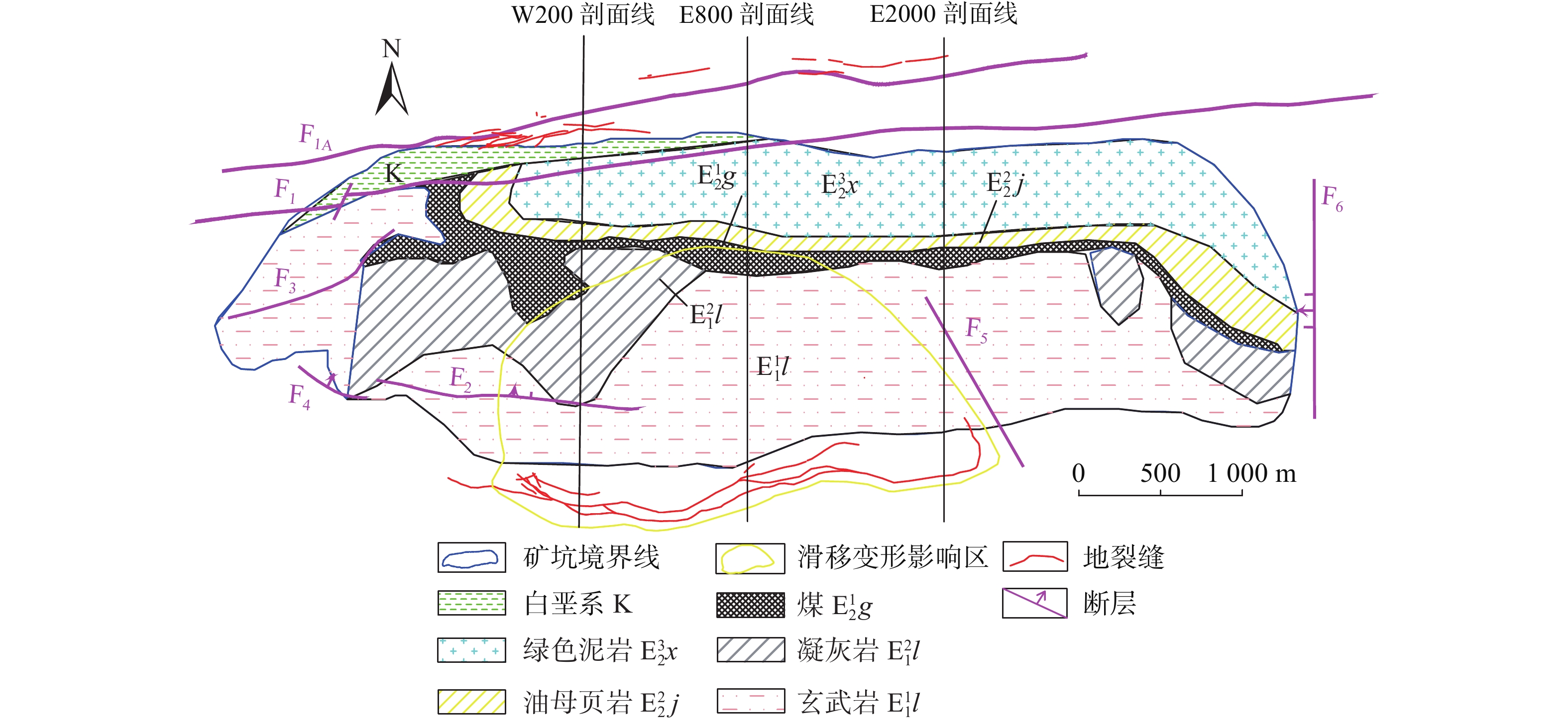
图 3 典型剖面的历年边坡轮廓线及地质剖面图
Figure 3. Slope contour and geological profile of typical profile over the years
![]()
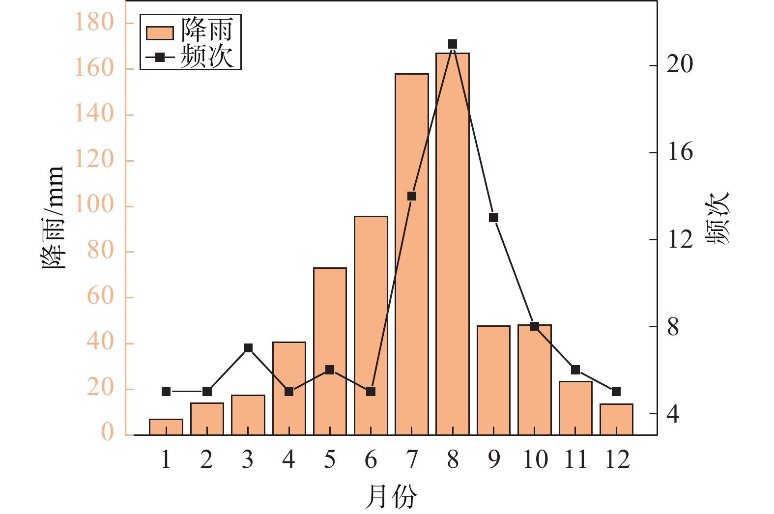
图 4 西露天矿滑坡灾害和降雨量在每月的分布
Figure 4. Monthly distribution of landslide disasters and rainfalls in West Open-pit Mine
![]()
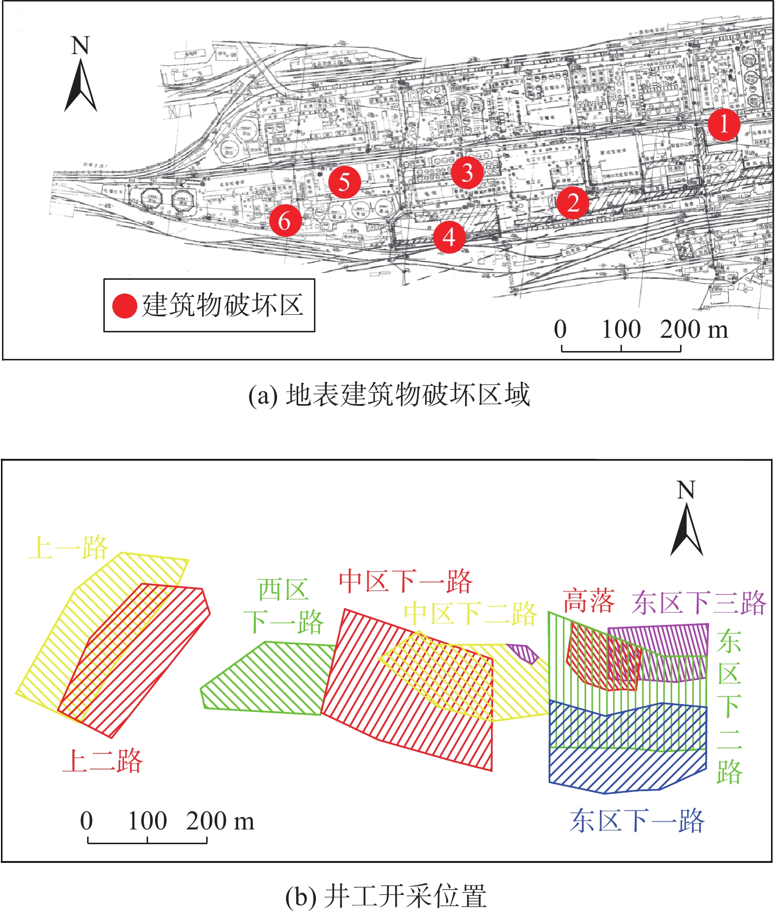
图 5 地表建筑物破坏区域及地下开采区域图
Figure 5. Map of damaged areas of surface buildings and underground mining areas
表 1 部分区域地下开采时间表
Table 1 Part of underground mining status table
采区 标高/m 开采时间 东区 下一路 −305~ −337 1952年10月—1955年12月 下二路 −342~ −380 1955年10月—1961年10月 下二高落 −342~ −362 1960年5月—1961年6月 下三路 −350~ −417 1962年5月—1964年5月 中区 下一路 −305~ −337 1954年3月—1958年4月 下二路 −342~ −380 1956年7月—1962年5月 下二高落 −342~ −378 1960年5月—1960年6月 西区 下一路 −305~ −337 1957年6月—1961年12月 上一路 −100~ −160 1964年1月—1973年12月 上二路南 −170~ −210 1971年1月—1973年12月 上二路北 −170~ −210 1972年6月—1977年5月  下载: 导出CSV
-
[1] 高国骧. 抚顺西露天矿开采技术[M]. 北京: 煤炭工业出版社, 1993 GAO Guoxiang. Mining technology of the Fushun west open pit[M]. Beijing: China Coal Industry Publishing House, 1993. (in Chinese)
[2] 王永胜, 郭静芸, 董高峰, 等. 辽宁抚顺西露天矿北帮边坡稳定性分析及变形分区[J]. 中国地质灾害与防治学报,2012,23(4):86 − 93. [WANG Yongsheng, GUO Jingyun, DONG Gaofeng, et al. Slope stability evaluation of Fushun west open-pit mine[J]. The Chinese Journal of Geological Hazard and Control,2012,23(4):86 − 93. (in Chinese with English abstract) WANG Yongsheng, GUO Jingyun, DONG Gaofeng, et al. Slope stability evaluation of Fushun west open-pit mine[J]. The Chinese Journal of Geological Hazard and Control, 2012, 23(4): 86-93. (in Chinese with English abstract)
[3] 滕超, 王雷, 刘宝华, 等. 辽宁抚顺西露天矿南帮滑坡应力变化规律及影响因素分析[J]. 中国地质灾害与防治学报,2018,29(2):35 − 42. [TENG Chao, WANG Lei, LIU Baohua, et al. Stress variation within the southern landslide of Fushun West Open-Pit and its influencing factors[J]. The Chinese Journal of Geological Hazard and Control,2018,29(2):35 − 42. (in Chinese with English abstract) TENG Chao, WANG Lei, LIU Baohua, et al. Stress variation within the southern landslide of Fushun West Open-Pit and its influencing factors[J]. The Chinese Journal of Geological Hazard and Control, 2018, 29(2): 35-42. (in Chinese with English abstract)
[4] 吴季寰, 张春山, 孟华君, 等. 抚顺西露天矿区滑坡易发性评价与时空特征分析[J]. 地质力学学报,2021,27(3):409 − 417. [WU Jihuan, ZHANG Chunshan, MENG Huajun, et al. Temporal and spatial characteristics of landslide susceptibility in the West open-pit mining area, Fushun, China[J]. Journal of Geomechanics,2021,27(3):409 − 417. (in Chinese with English abstract) DOI: 10.12090/j.issn.1006-6616.2021.27.03.037 WU Jihuan, ZHANG Chunshan, MENG Huajun, et al. Temporal and spatial characteristics of landslide susceptibility in the West open-pit mining area, Fushun, China[J]. Journal of Geomechanics, 2021, 27(3): 409-417. (in Chinese with English abstract) DOI: 10.12090/j.issn.1006-6616.2021.27.03.037
[5] 李泽闯. 抚顺西露天矿南帮滑坡滑动机制与滑坡破坏时间预测预报研究[D]. 长春: 吉林大学, 2017 LI Zechuang. Study on deformation mechanism and failure prediction of landslide in west open-pit mine in Fushun[D]. Changchun: Jilin University, 2017. (in Chinese with English abstract)
[6] 王宏飞. 抚顺市区地裂缝分布特征、成因机制及活动性预测模型研究[D]. 长春: 吉林大学, 2017 WANG Hongfei. Study on distribution characteristics, genetic mechanism and activity prediction model of ground fissures in Fushun City[D]. Changchun: Jilin University, 2017. (in Chinese with English abstract)
[7] 李淑艳. 抚顺市矿山环境地质灾害形成机制与防治对策研究[D]. 北京: 煤炭科学研究总院, 2008 LI Shuyan. The research of mining environmental geology disaster's forming mechanism and countermeasures of Fushun City[D]. Beijing: China coal research institute, 2008. (in Chinese with English abstract)
[8] 刘大勇, 王恩德, 宋建潮, 等. 抚顺西露天煤矿滑坡与降雨的关系及预报方法[J]. 灾害学,2008,23(2):50 − 54. [LIU Dayong, WANG Ende, SONG Jianchao, et al. The relation between landslide and rainfall and prediction method of western open-pit coal mine of Fushun[J]. Journal of Catastrophology,2008,23(2):50 − 54. (in Chinese with English abstract) DOI: 10.3969/j.issn.1000-811X.2008.02.012 LIU Dayong, WANG Ende, SONG Jianchao, et al. The relation between landslide and rainfall and prediction method of western open-pit coal mine of Fushun[J]. Journal of Catastrophology, 2008, 23(2): 50-54. (in Chinese with English abstract) DOI: 10.3969/j.issn.1000-811X.2008.02.012
[9] 翟文杰, 钟以章, 姜德录, 等. 抚顺西露天煤矿地质灾害预测[J]. 自然灾害学报,2006,15(4):132 − 137. [ZHAI Wenjie, ZHONG Yizhang, JIANG Delu, et al. Prediction of geological disaster in Fushunxilutian Coal Mine[J]. Journal of Natural Disasters,2006,15(4):132 − 137. (in Chinese with English abstract) DOI: 10.3969/j.issn.1004-4574.2006.04.024 ZHAI Wenjie, ZHONG Yizhang, JIANG Delu, et al. Prediction of geological disaster in Fushunxilutian Coal Mine[J]. Journal of Natural Disasters, 2006, 15(4): 132-137. (in Chinese with English abstract) DOI: 10.3969/j.issn.1004-4574.2006.04.024
[10] 高安琪, 王金安, 李飞, 等. 西露天矿周边建筑物损害区位特征分析[J]. 煤炭学报,2021,46(4):1320 − 1330. [GAO Anqi, WANG Jin’an, LI Fei, et al. Locational characteristics of damage on buildings around the West Open-pit Mine[J]. Journal of China Coal Society,2021,46(4):1320 − 1330. (in Chinese with English abstract) GAO Anqi, WANG Jin’an, LI Fei, et al. Locational characteristics of damage on buildings around the West Open-pit Mine[J]. Journal of China Coal Society, 2021, 46(4): 1320-1330. (in Chinese with English abstract)
[11] 陈毓. 抚顺西露天矿采空区北部区域地质灾害风险评估与适应性评价研究[J]. 矿业安全与环保,2021,48(3):106 − 111. [CHEN Yu. Study on risk assessment and adaptability evaluation of regional geological hazards in the northern part of goaf in Fushun west surface mine[J]. Mining Safety & Environmental Protection,2021,48(3):106 − 111. (in Chinese with English abstract) CHEN Yu. Study on risk assessment and adaptability evaluation of regional geological hazards in the northern part of goaf in Fushun west surface mine[J]. Mining Safety & Environmental Protection, 2021, 48(3): 106-111. (in Chinese with English abstract)
[12] 纪玉石, 申力, 刘晶辉. 采矿引起的倾倒滑移变形机理及其控制[J]. 岩石力学与工程学报,2005,24(19):3594 − 3598. [JI Yushi, SHEN Li, LIU Jinghui. Deformation mechanism and control of mining-induced toppling-displacement[J]. Chinese Journal of Rock Mechanics and Engineering,2005,24(19):3594 − 3598. (in Chinese with English abstract) DOI: 10.3321/j.issn:1000-6915.2005.19.032 JI Yushi, SHEN Li, LIU Jinghui. Deformation mechanism and control of mining-induced toppling-displacement[J]. Chinese Journal of Rock Mechanics and Engineering, 2005, 24(19): 3594-3598. (in Chinese with English abstract) DOI: 10.3321/j.issn:1000-6915.2005.19.032
[13] 申力, 纪玉石, 刘大勇, 等. 采矿引起的边坡倾倒滑移变形机理与变形安全性分析研究—以抚顺西露天矿边坡为例[J]. 中国地质灾害与防治学报,2006,17(3):63 − 68. [SHEN Li, JI Yushi, LIU Dayong, et al. Deformation mechanism and stability analysis of slope toppling-sliding rock mass due to mining:A case study on west open pit slope of Fushun Coal Mine[J]. The Chinese Journal of Geological Hazard and Control,2006,17(3):63 − 68. (in Chinese with English abstract) DOI: 10.3969/j.issn.1003-8035.2006.03.015 SHEN Li, JI Yushi, LIU Dayong, et al. Deformation mechanism and stability analysis of slope toppling-sliding rock mass due to mining: A case study on west open pit slope of Fushun Coal Mine[J]. The Chinese Journal of Geological Hazard and Control, 2006, 17(3): 63-68. (in Chinese with English abstract) DOI: 10.3969/j.issn.1003-8035.2006.03.015
[14] 杨天鸿, 芮勇勤, 唐春安, 等. 抚顺西露天矿蠕动边坡变形特征及稳定性动态分析[J]. 岩土力学,2004,25(1):153 − 156. [YANG Tianhong, RUI Yongqin, TANG Chunan, et al. Study on deformation features and dynamic stability of creeping slope of Fushun West Strip Mine[J]. Rock and Soil Mechanics,2004,25(1):153 − 156. (in Chinese with English abstract) DOI: 10.3969/j.issn.1000-7598.2004.01.033 YANG Tianhong, RUI Yongqin, TANG Chunan, et al. Study on deformation features and dynamic stability of creeping slope of Fushun West Strip Mine[J]. Rock and Soil Mechanics, 2004, 25(1): 153-156. (in Chinese with English abstract) DOI: 10.3969/j.issn.1000-7598.2004.01.033
[15] 中国煤炭学会露天开采专业委员会. 中国露天煤炭事业发展报告: 1914—2007[M]. 北京: 煤炭工业出版社, 2010 China Coal Society Open-pit Mining Professional Committee. Development report of open-pit coal industry in China[M]. Beijing: China Coal Industry Publishing House, 2010. (in Chinese)
[16] 毛佳睿, 武雄. 山西省黄土崩塌影响因素及时空分布特征[J]. 科学技术与工程,2020,20(10):3799 − 3807. [MAO Jiarui, WU Xiong. Influencing factors and temporal and spatial distribution characteristics of loess collapse in Shanxi Province[J]. Science Technology and Engineering,2020,20(10):3799 − 3807. (in Chinese with English abstract) MAO Jiarui, WU Xiong. Influencing factors and temporal and spatial distribution characteristics of loess collapse in Shanxi Province[J]. Science Technology and Engineering, 2020, 20(10): 3799-3807. (in Chinese with English abstract)
[17] 刘向峰, 郭子钰, 王来贵, 等. 降雨矿震叠加作用下抚顺西露天矿边坡稳定性分析[J]. 中国地质灾害与防治学报,2021,32(4):40 − 46. [LIU Xiangfeng, GUO Ziyu, WANG Laigui, et al. Analysis on the slope stability of Fushun West Open-pit Mine under superimposed action of rainfall, mine and earthquake[J]. The Chinese Journal of Geological Hazard and Control,2021,32(4):40 − 46. (in Chinese with English abstract) LIU Xiangfeng, GUO Ziyu, WANG Laigui, et al. Analysis on the slope stability of Fushun West Open-pit Mine under superimposed action of rainfall, mine and earthquake[J]. The Chinese Journal of Geological Hazard and Control, 2021, 32(4): 40-46. (in Chinese with English abstract)
[18] 李绍红, 朱建东, 王少阳, 等. 考虑降雨类型的基岩型浅层边坡稳定性分析方法[J]. 水文地质工程地质,2018,45(2):131 − 135. [LI Shaohong, ZHU Jiandong, WANG Shaoyang, et al. Stability analysis methods for the bedrock shallow slope considering rainfall types[J]. Hydrogeology & Engineering Geology,2018,45(2):131 − 135. (in Chinese with English abstract) LI Shaohong, ZHU Jiandong, WANG Shaoyang, et al. Stability analysis methods for the bedrock shallow slope considering rainfall types[J]. Hydrogeology & Engineering Geology, 2018, 45(2): 131-135. (in Chinese with English abstract)
[19] 张勇, 温智, 程英建. 四川巴中市滑坡灾害与降雨雨型关系探讨[J]. 水文地质工程地质,2020,47(2):178 − 182. [ZHANG Yong, WEN Zhi, CHENG Yingjian. A discussion of the relationship between landslide disaster and rainfall types in Bazhong of Sichuan[J]. Hydrogeology & Engineering Geology,2020,47(2):178 − 182. (in Chinese with English abstract) ZHANG Yong, WEN Zhi, CHENG Yingjian. A discussion of the relationship between landslide disaster and rainfall types in Bazhong of Sichuan[J]. Hydrogeology & Engineering Geology, 2020, 47(2): 178-182. (in Chinese with English abstract)
[20] 马水山, 雷俊荣, 张保军, 等. 滑坡体水岩作用机制与变形机理研究[J]. 长江科学院院报,2005,22(5):37 − 39. [MA Shuishan, LEI Junrong, ZHANG Baojun, et al. Study on rock-water interaction and deformation mechanism of landslide[J]. Journal of Yangtze River Scientific Research Institute,2005,22(5):37 − 39. (in Chinese with English abstract) DOI: 10.3969/j.issn.1001-5485.2005.05.011 MA Shuishan, LEI Junrong, ZHANG Baojun, et al. Study on rock-water interaction and deformation mechanism of landslide[J]. Journal of Yangtze River Scientific Research Institute, 2005, 22(5): 37-39. (in Chinese with English abstract) DOI: 10.3969/j.issn.1001-5485.2005.05.011
[21] 刘新荣, 熊飞, 李滨, 等. 水力作用下岩质斜坡破坏机制和稳定性分析研究现状[J]. 中国岩溶,2020,39(4):547 − 558. [LIU Xinrong, XIONG Fei, LI Bin, et al. Current situation of research on failure mechanism and stability of rock slopes under hydraulic action[J]. Carsologica Sinica,2020,39(4):547 − 558. (in Chinese with English abstract) LIU Xinrong, XIONG Fei, LI Bin, et al. Current situation of research on failure mechanism and stability of rock slopes under hydraulic action[J]. Carsologica Sinica, 2020, 39(4): 547-558. (in Chinese with English abstract)
[22] 张秀梅. 基于PSR模型的煤炭资源型城市生态安全评价研究[D]. 北京: 北京林业大学, 2011 ZHANG Xiumei. Ecological security evaluation of coal-mining supported city based on PSR model[D]. Beijing: Beijing Forestry University, 2011. (in Chinese with English abstract)


计量
- 文章访问数: 302
- HTML全文浏览量: 216
- PDF下载量: 452
 邮件订阅
邮件订阅 RSS
RSS