Hazard assessment of typical gully debris flow in Anning river:A case study at the Lengzi gully
-
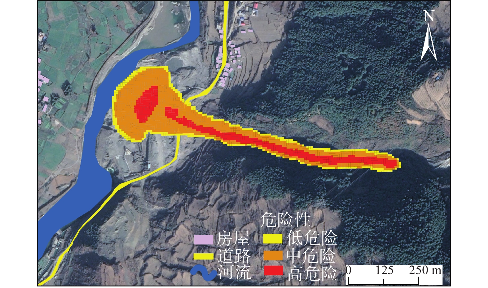
摘要: 冕宁县安宁河流域为地质灾害密集分布区,安宁河断裂穿越于此,构造复杂,冷渍沟在上游左岸发育。在强降雨条件下,该沟就会暴发泥石流,堵塞安宁河流域和掩埋杀叶马村房屋和道路。冷渍沟泥石流具有流域面积小,主沟长度短,沟床纵比降大等特征,为了研究安宁河流域内泥石流的危险性,以冷渍沟为例,分析不同降雨周期下的泥石流暴发强度,模拟泥石流的运动过程并进行危险性评价。模拟的最大流速、最大堆积深度和降雨强度三者结合建立冷渍沟泥石流危险性评价模型。研究结果表明,冷渍沟泥石流危险范围内高危险区域占27%,主要集中在松散固体物质较多的沟道,中危险性区域和低危险区域各占56%和17%,该结论为危险范围内的居民和重点设施的风险管控提供参考。Abstract: The Anning river basin is a densely distributed area of geological hazards, where the Anning river rift crosses, with complex tectonics and the Lengzi gully developing in the upper left bank. The gully is subject to mudslides under heavy rainfall conditions, blocking the Anning river basin and burying houses and roads in the village of Yema. Lengzi gully debris flow has the characteristics of small area,a short main trench and a large channel longitudinal slope. To explore these damage, taking Lengzi gully as an example, the intensity of debris flow burst under different rainfall cycles is analyzed, and the movement process of debris flow is simulated and the risk assessment is carried out. Combined with the simulated maximum flow velocity, maximum accumulation depth and rainfall intensity,the hazard assessment model is established.The results show that in the danger range of Lengzi gully debris flow, the high risk area accounts for 27%, mainly distributed in the channel with more loose solid materials, and the medium risk area and low risk area account for 56% and 17%, respectively. this conclusion provides a scientific basis for the monitoring and early warning of key facilities in the danger range.
-
Keywords:
- Lengzi gully /
- FLO-2D /
- gully debris flow /
- hazard assessment
-
0. 引言
川藏铁路即新建成都至拉萨的铁路,全长约1832 km,是西藏重要东出通道。川藏铁路经过四川省西北部与西藏自治区东南部,处于欧亚板块的接触带,具有构造运动强烈、新构造运动活跃,地震活动频度高等特征,加之受到青藏高原强烈隆升作用的影响,导致区内的地形起伏大,沟谷地貌发育,山高谷深、地质条件复杂、断裂构造发育,其高陡斜坡、破碎岩土体等地形地貌广泛分布,为滑坡、泥石流、崩塌等山地灾害的形成提供了“有利”的条件。受内外营力的相互作用,沿线区域成为山地灾害最为发育、最为活跃、危害最为严重的地区之一[1-3]。根据调查统计,川藏铁路沿线共发育山地灾害1359处,其中崩塌滑坡747处,包含大型(体积≥100×104 m3)、特大型(体积≥1000×104 m3)滑坡147处,占到崩滑总数的接近20%。大型滑坡因其规模巨大,一旦发生,造成的危害和经济损失尤为严重。例如,川藏铁路沿线区域波密县102大型滑坡,体积达510×104 m3,毁坏国道公路近10 km[4]。川藏铁路沿线发育广泛、危害严重的大型滑坡已成为铁路局部乃至全线的关键控制节点,关乎工程建设的成败。
川藏铁路沿线区域有关滑坡等山地灾害有相关学者进行了研究。例如魏永幸、程谦恭等对线路沿线巨型、高速远程滑坡动力学过程及其演化机理与防治对策进行了研究[1]。张小刚、梁光模等系统地查明了西藏主要干线公路沿线滑坡的分布、类型、活动特征、影响因素及机理和防治对策[4-5];李秀珍等[6],钟卫等[7],边江豪等[8]分析了川藏交通廊道康定至林芝段崩滑的空间特征和潜在危害,并归纳总结了可能产生的危害方式;钟卫等[7]在调查川藏铁路康定—昌都段沿线崩滑灾害基础上,提出了基于崩滑灾害影响的地质灾害选线建议。已有的研究成果为川藏铁路山地灾害的进一步研究奠定了重要基础。但是目前针对川藏铁路工程,有关大型滑坡的研究较少,尤其是大型滑坡的危险度评价方面。
目前,关于滑坡危险性评价方法有层次分析法、随机森林法、新组合赋权法等多种[9-11],其中不同的评价方法有不同特点。贡献率权重叠加模型结构简单、物理意义清楚、不受使用区域限制、人为主观因素影响较小[12]。因此,本研究在对拟建川藏铁路沿线崩塌滑坡灾害进行野外实地调查和遥感解译的基础上,以铁路沿线危害较为严重的大型滑坡(含特大型滑坡)作为主要研究对象,采用贡献率权重叠加方法对铁路沿线区域进行大型滑坡危险性评价,以期为川藏铁路工程的选定线及安全建设和运营提供科学参考和防灾减灾依据。
1. 川藏铁路沿线自然地质环境背景
川藏铁路横穿青藏高原东南缘地形急变带、是迄今为止人类历史上最具挑战性的铁路建设工程[13],其穿越21座4000 m以上的雪山,横跨14条江河,主要途径具有河谷、侵蚀剥蚀和冰川作用的三大地貌单元,即山前冲积平原区、川西盆地—高原过渡区、青藏高原地貌区[14]。
铁路沿线岩性复杂,各个时代地层发育齐全,沉积类型繁多,其中三叠系分布最广,以海相或海陆相成因为主。川藏铁路地处印度板块与欧亚板块相互碰撞的汇聚带附近,构造复杂,大小活动断层广布,主要断裂带有:鲜水河断裂、理塘断裂、金沙江断裂、澜沧江断裂、怒江断裂、雅鲁藏布断裂等。沿线经过由多期区域构造运动形成的板块缝合带,以及扬子准地台、松潘—甘孜褶皱带、昌都地块、改则—那曲褶皱带、拉萨地块三大构造单元;同时横跨南北地震带与青藏高原地震区,烈度高,地震活动十分频繁,历史上曾多次发生7级以上地震。
铁路沿线东部为太平洋与印度洋气流影响的海洋性气候,西部为西北环流影响的大陆性气候。地势对气候控制程度十分明显,铁路沿线降水、气温、湿度等气候因素复杂多变,不同海拔高度气候差异极为悬殊。铁路跨越长江、澜沧江、怒江、雅鲁藏布4大水系,途经金沙江、澜沧江、怒江、帕隆藏布、尼洋河、拉萨河6大水系干流。
2. 川藏铁路沿线大型滑坡灾害概况
自2015年以来,课题组历时3年,通过对铁路沿线崩塌滑坡灾害的10多次野外实地调查,并结合多源多时相遥感影像数据的判译,共查明川藏铁路沿线共发育有崩滑灾害共计747处,崩塌334处,滑坡413处,其中大型、特大型滑坡共147处(图1)。按照中国地质调查局的滑坡崩塌泥石流灾害详细调查规范将滑坡体积规模以大型(100×104~1000×104 m3)与特大型(大于1000×104 m3)来划分,其中大型滑坡106处,特大型41处。初步统计,大型滑坡的总规模为3.98×10⁸ m3,特大型滑坡的总规模为14.09×10⁸ m3。实地调查的川藏铁路沿线典型大型滑坡(含特大型滑坡,下同)如图2所示。
川藏铁路全长1800多公里,跨越了多个县/市区。依据铁路火车站区间段划分,大型滑坡主要分布于白玉至江达段、昌都至八宿段、朗县至加查段等区段,其中昌都至八宿段分布数量最多,为61处,其次白玉至江达段、朗县至加查段,数量分别为44处和17处。灾害分布密度白玉至江达段最大,线密度为0.53处/km,朗县至加查段和昌都到八宿段次之,线密度分别为0.36处/km、0.34处/km(表1)。
川藏铁路横跨了四川与西藏两个省区,8个市/州,30多个县/区。根据行政区域统计大型滑坡分布特征,可以看出八宿县分布的大型滑坡数量最多,占到大型滑坡总数的42.86%,其次为白玉县,占到大型滑坡总数的23.13%(图3)。
表 1 川藏铁路沿线大型(含特大型)滑坡分段数量统计表Table 1. Statistical table on the number of large landslides along the Sichuan-Tibet Railway编号 区段 线路长度/km 大型滑坡/处 特大型/处 总数量/处 线密度处/km 1 成都至康定段 239.78 9 0 9 0.040 2 康定至白玉段 423.75 1 1 2 0.005 3 白玉至江达段 83.72 39 5 44 0.530 8 江达至昌都段 119.86 5 0 5 0.040 9 昌都至八宿段 177.58 31 30 61 0.340 10 八宿至波密段 206.39 1 1 2 0.010 11 波密至林芝段 208.81 2 2 4 0.020 12 林芝至朗县段 164.21 2 0 2 0.010 13 朗县至加查段 46.96 16 1 17 0.360 14 加查到拉萨段 211.79 0 1 1 0.005 合计 1882.85 106 41 147 — 3. 基于贡献率权重模型的滑坡危险度区划方法
滑坡危险度区划是将一定区域内滑坡发育的内部条件、诱发滑坡发生的外部条件以及滑坡所造成的影响进行综合统计,定量或半定量地评价区域内滑坡的危害程度[15],其区划内容主要包括:选择评价指标、建立区域模型、确定危险度划分等级、可靠性检验等[16]。
在分析背景条件的基础上,本文选用贡献率权重叠加模型对研究区进行滑坡危险度区划。首先统计各本底因子对滑坡发育影响的贡献率值;接着对各本底因子的贡献率进行均值化、归一化处理,并计算各因子的自权重和各因子间的互权重;最后将各因子的贡献率、自权重、互权重相乘叠加得到区域内滑坡危险度分布情况,按照分区标准对危险度进行分区从而得到滑坡危险度区划结果(图4)[17-22]。其中本底因子是指影响滑坡形成和孕育的基本环境因素,如坡度、高差、坡向等,不考虑降雨、地震等诱发因素。贡献率是分析滑坡发育本底因子作用程度的一个指标。
具体步骤如下:
(1)计算本底因子贡献率
滑坡发育本底因子作用程度可通过本底因子贡献率进行量化,根据下式进行计算:
$$ {U_{0i}}\left( \% \right) = {U_i}\Big/\sum {{U_i}} \times 100\% $$ (1) 式(1)中,U0i为滑坡本底因子贡献率,Ui为本底因子的滑坡贡献指数,i为本底因子(i =1, 2, ···, 6)。
(2)计算本底因子权重
本底因子权重分为自权重与互权重两部分,其中自权重是某一因子内部不同取值范围相互之间的权重,而互权重是各因子相互之间的权重。
将各滑坡本底因子的贡献率按高、中、低3级贡献程度划分后,分别按照下式计算各因子的权值。
$$ {W_i} = {U_{0i}}\Big/\sum {{U_{0i}}} $$ (2) 式中:Wi——本底因子自权重;
U0i——本底因子贡献率。
互权重是通过自权重来计算,其计算公式如下:
$$ {W_i}' = {U_j}\Big/\sum {{U_j}} $$ (3) 式中:
${W}_{i}^{'} $ ——本底因子互权重;Uj——各因子综合贡献率(Uj=∑U0i);
j——滑坡评价指标(j=1, 2, 3)。
(3)危险度区划
用贡献权重叠加法进行危险度区划公式如下:
$$ H=\sum\limits_{i=1}^{6}{W}_{i}{W}_{i}^{'}{U}_{i} $$ (4) 式中:H——危险度;
Wi——自权重;
$ {W}_{i}^{'} $ ——互权重;Ui——贡献指数。
4. 川藏铁路沿线大型滑坡危险性区划
4.1 铁路沿线大型滑坡发育本底因子贡献率
依据已有研究,结合对川藏铁路沿线大型滑坡灾害及其环境背景调查分析,选择与大型滑坡发育密切相关的坡度、地层岩性、高差、坡向、断裂带、河流水系共6个因子作为危险性评价的本底因子(图5)。
根据贡献率权重模型,以及拟建铁路沿线147处大型滑坡灾害点的分布数量、面积、体积三个量化的滑坡评价指标,利用上述公式(1),对川藏铁路沿线一定范围内的坡度、高差、地层岩性、坡向、断裂带、河流水系对滑坡发育的贡献率进行计算。
在具体计算中,用ArcGIS对坡度进行处理,每隔5°进行级别划分,将坡度分为9级,再根据上述分析对坡度因子不同级别的贡献率进行计算,结果见图6(a);将铁路沿线的高差每100 m分1级,共分为12级,得出高差因子贡献率信息,见图6(b);利用1∶20万的地质图获得滑坡点的地层岩性,包括前震旦系(AnZ)、元古界(Pt)、泥盆系(D)、石炭系(C)、二叠系(P)、三叠系(T)、侏罗系(J)、白垩系(K)、古近系(E)、新近系(N)、第四系(Q)共11种类型,得出地层岩性因子贡献率信息,见图6(c);将坡向划分为北(N)、东北(EN)、东(E)、东南(ES)、南(S)、西南(WS)、西(W)、西北(WN)共8个方向,得出坡向贡献率信息,见图6(d)。断裂带密度是指单位面积内断裂带的长度,以0.01间隔分一级,共分成9个等级,得出断裂带贡献率信息,见图6(e)。水系密度是指单位面积内河流的长度,用水系密度作为河流水系的分析因子,每0.01间隔分一级,分成9个等级,得出河流水系贡献率信息,见图6(f)。
4.2 铁路沿线大型滑坡发育本底因子权重
基于上述各本底因子的贡献率计算结果,利用上述式(2)和式(3)分别计算高差、坡度、坡向、地层岩性、断裂带、河流水系等各本底因子的自权重与互权重,其计算结果见表2。
表 2 川藏铁路大型滑坡本底因子权重Table 2. Contributing weights of background factors of large landslides in Sichuan-Tibet Railway因子 自权重 互权重 高 中 低 高差 0.52 0.31 0.17 0.17 坡度 0.60 0.35 0.06 0.15 坡向 0.50 0.31 0.19 0.18 地层岩性 0.57 0.34 0.09 0.17 断裂带 0.57 0.37 0.07 0.17 河流水系 0.62 0.31 0.07 0.16 4.3 铁路沿线大型滑坡危险性区划结果
4.3.1 危险性区划
采用贡献率权重因子叠加模型,根据公式(4)将滑坡本底因子的贡献自权重、互权重、贡献率相乘叠加,以90 m×90 m网格单元为基本评价单元,得到铁路沿线连续空间的滑坡危险度值。然后,再利用ArcGIS中的自然断点法对连续空间的滑坡危险度值进行分区,分为低危险度区、中危险度区、高危险度区3个区。3个区间的取值分别为0.0176~0.1001、0.1001~0.1825、0.1825~0.2649,最终得到川藏铁路沿线的危险性区划图(图7)。
4.3.2 结果分析
川藏铁路沿线研究区总面积为143442.6 km2,根据大型滑坡危险性区划结果(图8、表3),低度危险区的面积为35918.5 km2,中度危险区的面积为95484.3 km2,高度危险区的面积为12039.7 km2;其中中度危险区的面积最多,占到66.5%,其次为低度危险区。高度危险区主要集中在邦达—八宿段、古乡—拉月段、白玉—江达段。
表 3 不同危险度等级区间大型滑坡分布特征Table 3. Characteristics of large landslides of different hazard rating危险度等级区划 总面积/ km2 面积所占百分比/ % 滑坡点数/ 处 数量所占百分比 /% 滑坡密度/( 处·km−2) 低度危险区 35918.5 25.0 32 21.8 0.00089 中度危险区 95484.3 66.5 91 61.9 0.00095 高度危险区 12039.7 8.5 24 16.3 0.00199 总计 143442.6 100 147 100 — 从大型滑坡点分布数量分析,中度危险区分布的大型滑坡数量最多,为91处,占到大型滑坡总数的61.9%,其次是低度危险区,高度危险区滑坡分布的数量最少。
从滑坡分布密度来看,滑坡危险区的等级越高,大型滑坡的分布密度越大。高度危险区滑坡分布密度为0.00199处/km2,为最高,约为中度危险区或低度危险区的2倍。
由此可见,根据贡献率权重模型计算得出的川藏铁路沿线大型滑坡危险度等级与实际调查的滑坡分布密度结果是一致的。
5. 结语
川藏铁路工程是国家重大基础设施建设项目,保障铁路的顺利建设和后期安全运营十分重要。本文以铁路沿线发育广泛、危害严重的大型滑坡(含特大型)作为主要研究对象,在对大型滑坡灾害进行野外实地调查和遥感解译的基础上,基于ArcGIS平台,采用贡献率权重模型对铁路沿线区域进行了大型滑坡危险性评价,并利用自然断点法对危险性评价结果进行分区及统计分析。结果表明:
(1)拟建川藏铁路沿线共发育大型、特大型滑坡共147处,其中大型滑坡106处,特大型滑坡41处,主要分布于白玉至江达段、昌都至八宿段、朗县至加查段等区段。
(2)铁路沿线处于高中低三个等级危险区的面积分别为35918.5,95484.3,12039.7 km2。滑坡危险区的等级越高,大型滑坡的分布密度越大。高度危险区大型滑坡分布密度为0.00199处/km2,约为中度或低度危险区的2倍。高度危险区主要集中在邦达—八宿段、古乡—拉月段和白玉—江达段。
(3)根据贡献率权重模型计算出川藏铁路沿线大型滑坡危险度等级与野外实地调查的大型滑坡分布密度是一致的。贡献率权重模型用于川藏铁路沿线大型滑坡危险性区划是可行的。相关研究成果可以为川藏铁路工程的选定线、安全建设提供科学参考和防灾减灾依据。
下一步研究中,将在充分考虑川藏铁路沿线影响大型滑坡危险性的不同本底因素的基础上,进一步考虑引起铁路沿线大型滑坡发生的降雨、地震等诱发因素的影响,分不同工程地质区段分别建立考虑诱发因素影响下铁路沿线大型滑坡的动态危险性评价及预测模型。
-
表 1 FLO-2D手册建议的曼宁系数值
Table 1 Manning coefficient values suggested by the FLO-2D manual
地表状况 曼宁系数值 地表状况 曼宁系数值 茂密草地 0.17~0.8 耕地 0.0008~0.012 植物茂密灌木草地 0.17~0.48 轮休耕地 0.06~0.22 杂林灌木、牧草地 0.3~0.4 传统耕地 0.06~0.16 一般草地植生 0.2~0.4 以整地农地 0.3~0.5 植物稀疏粗糙地 0.2~0.3 梯田 0.07~0.17 矮草原 0.1~0.2 无耕农作物 0.17~0.47 稀疏草原 0.05~0.13 有块石分布开阔地 0.1~0.2 有块石分布稀疏植被 0.09~0.34 沥青混凝土 0.02~0.005 表 2 冷渍沟泥石流20年一遇参数选取
Table 2 The parameter of Lengzi gully under 20 years rainfall frequency
流域面积F/m2 沟道长度L/km 屈服应力τy/MPa 黏滞系数η 层流阻力系数K 曼宁系数nc 0.62×10⁶ 1.49 4903 5704 2280 0.18 放大系数BF 径流深度H /cm 汇流时间τ/h 体积浓度/Cv 洪峰流量Qp/(cm3·s−1) 洪水流量Wp/104 m3 2.5 26 1.6 0.6 11.57×10⁶ 1.612 表 3 冲沟冷渍沟泥石流对比验证表
Table 3 Comparison and verification table of debris flow in Lengzi gully
泥石流沟道名称 设计频率 /% 最大冲出长度/m 最大冲出宽度/m 冲出范围/(104 m2) 精度/% 模拟 实际 模拟 实际 模拟 实际 重叠 冷渍沟 5.00 207.00 190.00 147.00 187.00 1.52 1.77 1.32 86 表 4 研究区泥石流强度划分表
Table 4 Debris flow intensity division table in the study area
危险等级 最大堆积
深度/m关系式 最大堆积深度/m与
最大流速/(m·s−1)乘积高 H≥2.5 OR VH≥2.5 中 0.5≤H<2.5 AND 0.5≤VH<2.5 低 H<0.5 AND VH<0.5 -
[1] 中华人民共和国国土资源部. 泥石流灾害防治工程勘查规范: DZ/T 0220—2006[S]. 北京: 中国标准出版社, 2006 Ministry of Land and Resources of the People's Republic of China. Specification of geological investigation for debris flow stabilization: DZ/T 0220—2006[S]. Beijing: Standards Press of China, 2006. (in Chinese)
[2] 倪化勇. 人工降雨条件下冲沟型泥石流起动试验研究[J]. 工程地质学报,2015,23(1):111 − 118. [NI Huayong. Field experiments for groove-type debris flow initiation with artificial rainfall[J]. Journal of Engineering Geology,2015,23(1):111 − 118. (in Chinese with English abstract) NI Huayong. Field experiments for groove-type debris flow initiation with artificial rainfall[J]. Journal of Engineering Geology, 2015, 23(1): 111-118. (in Chinese with English abstract)
[3] 李秀珍, 刘希林, 苏鹏程. 四川凉山州安宁河流域泥石流危险性评价[J]. 防灾减灾工程学报,2005,25(4):426 − 430. [LI Xiuzhen, LIU Xilin, SU Pengcheng. Assessment on regional debris flow hazardousness of Anning River valley in Liangshan prefecture, Sichuan[J]. Journal of Disaster Pnevention and Mitigation Engineering,2005,25(4):426 − 430. (in Chinese with English abstract) LI Xiuzhen, LIU Xilin, SU Pengcheng. Assessment on regional debris flow hazardousness of Anning River valley in Liangshan prefecture, Sichuan[J]. Journal of Disaster Pnevention and Mitigation Engineering, 2005, 25(4): 426-430. (in Chinese with English abstract)
[4] BERTOLO P, WIECZOREK G F. Calibration of numerical models for small debris flows in Yosemite Valley, California, USA[J]. Natural Hazards and Earth System Sciences,2005,5(6):993 − 1001. DOI: 10.5194/nhess-5-993-2005
[5] 龚柯, 杨涛, 夏晨皓, 等. 基于FLO-2D的泥石流危险性评价:以四川省汶川县绵虒镇簇头沟为例[J]. 水资源与水工程学报,2017,28(6):134 − 138. [GONG Ke, YANG Tao, XIA Chenhao, et al. Assessment on the hazard of debris flow based on FLO-2D: A case study of debris flow in Cutou gully, Wenchuan, Sichuan[J]. Journal of Water Resources and Water Engineering,2017,28(6):134 − 138. (in Chinese with English abstract) DOI: 10.11705/j.issn.1672-643X.2017.06.23 GONG Ke, YANG Tao, XIA Chenhao, et al. Assessment on the hazard of debris flow based on FLO-2D: a case study of debris flow in Cutou Gully, Wenchuan, Sichuan[J]. Journal of Water Resources and Water Engineering, 2017, 28(6): 134-138. (in Chinese with English abstract) DOI: 10.11705/j.issn.1672-643X.2017.06.23
[6] CHRISTEN M, KOWALSKI J, BARTELT P. RAMMS: Numerical simulation of dense snow avalanches in three-dimensional terrain[J]. Cold Regions Science and Technology,2010,63(1/2):1 − 14.
[7] NOCENTINI M, TOFANI V, GIGLI G, et al. Modeling debris flows in volcanic terrains for hazard mapping: the case study of Ischia Island (Italy)[J]. Landslides,2015,12(5):831 − 846. DOI: 10.1007/s10346-014-0524-7
[8] QUAN L B, BLAHUT J, VAN W C J, et al. The application of numerical debris flow modelling for the generation of physical vulnerability curves[J]. Natural Hazards and Earth System Science,2011,138(11):2047 − 2060.
[9] 余宏明, 袁宏成, 唐辉明. 巴东县新城区冲沟泥石流危险度评价[J]. 水文地质工程地质, 2003, 30(增刊1): 47 − 49 YU Hongming, YUAN Hongcheng, TANG Huiming. Fuzzy comprehendsive evaluation method to evaluate debris flow risk factor in Badong new city[J]. Hydrogeology & Engineering Geology, 2003, 30(Sup 1): 47 − 49. (in Chinese with English abstract)
[10] 詹钱登, 萧凯文, 徐郁超, 等. 应用 FLO-2D及 Debris 2D模拟羌黄坑集水区内土石流流动特性差异之研究[J]. 中华防灾学刊,2015,7(2):239 − 247. [ZHAN Qiandeng, XIAO Kaiwen, XU Yuchao, et al. Study on the difference of flow characteristics of soil-rock flow in Qianghuangkeng catchment area by using FLO-2D and Debris 2D[J]. Chinese Journal of Disaster Prevention,2015,7(2):239 − 247. (in Chinese with English abstract) ZHAN Qiandeng, XIAO Kaiwen, XU Yuchao, et. al. , Study on the difference of flow characteristics of soil-rock flow in Qianghuangkeng catchment area by using FLO-2D and Debris 2D[J]. Chinese Journal of Disaster Prevention. 2015, 7(2): 239-247. ( in Chinese with English abstract
[11] 曹鹏, 侯圣山, 陈亮, 等. 基于数值模拟的群发性泥石流危险性评价:以甘肃岷县麻路河流域为例[J]. 中国地质灾害与防治学报,2021,32(2):100 − 109. [CAO Peng, HOU Shengshan, CHEN Liang, et al. Risk assessment of mass debris flow based on numerical simulation: An example from the Malu River Basin in Min County[J]. The Chinese Journal of Geological Hazard and Control,2021,32(2):100 − 109. (in Chinese with English abstract) CAO Peng, HOU Shengshan, CHEN Liang, et al. Risk assessment of mass debris flow based on numerical simulation: an example from the Malu River Basin in Min County[J]. The Chinese Journal of Geological Hazard and Control, 2021, 32(2): 100-109. (in Chinese with English abstract)
[12] 唐川, 李为乐, 丁军, 等. 汶川震区映秀镇“8·14”特大泥石流灾害调查[J]. 地球科学,2011,36(1):172 − 180. [TANG Chuan, LI Weile, DING Jun, et al. Field investigation and research on giant debris flow on August 14, 2010 in Yingxiu Town, epicenter of Wenchuan earthquake[J]. Earth Science,2011,36(1):172 − 180. (in Chinese with English abstract) TANG Chuan, LI Weile, DING Jun, et al. Field investigation and research on giant debris flow on August 14, 2010 in yingxiu town, epicenter of Wenchuan earthquake[J]. Earth Science, 2011, 36(1): 172-180. (in Chinese with English abstract)
[13] 崔鹏, 邹强. 山洪泥石流风险评估与风险管理理论与方法[J]. 地理科学进展,2016,35(2):137 − 147. [CUI Peng, ZOU Qiang. Theory and method of risk assessment and risk management of debris flows and flash floods[J]. Progress in Geography,2016,35(2):137 − 147. (in Chinese with English abstract) DOI: 10.18306/dlkxjz.2016.02.001 CUI Peng, ZOU Qiang. Theory and method of risk assessment and risk management of debris flows and flash floods[J]. Progress in Geography, 2016, 35(2): 137-147. (in Chinese with English abstract) DOI: 10.18306/dlkxjz.2016.02.001
[14] 牛全福, 陆铭, 李月锋, 等. 基于灰色关联与粗糙依赖度的甘肃兰州市区泥石流危险性评价[J]. 中国地质灾害与防治学报,2019,30(5):48 − 56. [NIU Quanfu, LU Ming, LI Yuefeng, et al. Hazard assessment of debris flow in Lanzhou City of Gansu Province based on methods of grey relation and rough dependence[J]. The Chinese Journal of Geological Hazard and Control,2019,30(5):48 − 56. (in Chinese with English abstract) NIU Quanfu, LU Ming, LI Yuefeng, et al. Hazard assessment of debris flow in Lanzhou City of Gansu Province based on methods of grey relation and rough dependence[J]. The Chinese Journal of Geological Hazard and Control, 2019, 30(5): 48-56. (in Chinese with English abstract)
[15] 常鸣, 唐川. 基于水动力的典型矿山泥石流运动模式研究[J]. 水利学报,2014,45(11):1318 − 1326. [CHANG Ming, TANG Chuan. Study on typical movement model in mine debris flow based on hydrodynamic force conditions[J]. Journal of Hydraulic Engineering,2014,45(11):1318 − 1326. (in Chinese with English abstract) CHANG Ming, TANG Chuan. Study on typical movement model in mine debris flow based on hydrodynamic force conditions[J]. Journal of Hydraulic Engineering, 2014, 45(11): 1318-1326. (in Chinese with English abstract)
[16] 林文, 周伟, 李靖, 等. 基于Flow-R和FLO-2D耦合模型的沟谷型泥石流危险性评价[J/OL]. 人民长江: 1 − 9 LIN Wen, ZHOU Wei, LI Jing, et al. Debris flow hazard assessment based on combination of Flow-R and FLO-2D models[J/OL]. Yangtze River: 1 − 9. https://kns.cnki.net/kcms/detail/detail.aspx?bcode=CAPJ&dbname=CAPJLAST&filename=RIVE20211008000&uniplatform=NZKPT&v=HFdcQQN9Fr2BnwrB79d72ZrNvTI4uEHW_decSY9iPILe_gw9fCRwPOFDhHUORNjy (in Chinese with English abstract)
[17] 陈兴长, 游勇, 陈晓清, 等. 安宁河上游冷渍沟泥石流特征及其发展趋势[J]. 长江流域资源与环境,2012,21(1):122 − 128. [CHEN Xingzhang, YOU Yong, CHEN Xiaoqing, et al. Characteristics and development trends of debris flows of lengzi gully in the upper Anning River, southwest Sichuan, China[J]. Resources and Environment in the Yangtze Basin,2012,21(1):122 − 128. (in Chinese with English abstract) CHEN Xingzhang, YOU Yong, CHEN Xiaoqing, LIU Jinfeng, HUANG Kai ], YOU Yong, CHEN Xiaoqing, et al. Characteristics and development trends of debris flows of lengzi gully in the upper Anning River, southwest Sichuan, China[J]. Resources and Environment in the Yangtze Basin, 2012, 21(1): 122-128. (in Chinese with English abstract)
[18] ADEGBE M, ALKEMA D, JETTEN V G, et al. Post seismic debris flow modelling using FLO-2D: Case study of Yingxiu, Sichuan Province, China[J]. Journal of Geography and Geology,2013,5(3):101 − 115.
[19] O’BRIEN J S, JULIEN P Y. Physical properties and mechanics of hyperconcentrated sediment flows[J]. Flash Floods and Debris Flow Hazards in Utah,1985:260 − 279.
[20] 四川省水电局. 四川省水文手册[M]. 四川省水利电力局水文总站图书出版社, 1984 Sichuan Provincial Hydropower Bureau. Sichuan province hydrology manual[M]. Sichuan Provincial Water Resources and Electric Power Bureau Hydrology Station Book Press, 1984. (in Chinese)
[21] PENG S H, LU S C. FLO-2D simulation of mudflow caused by large landslide due to extremely heavy rainfall in southeastern Taiwan during Typhoon Morakot[J]. Journal of Mountain Science,2013,10(2):207 − 218. DOI: 10.1007/s11629-013-2510-2
[22] 常鸣, 窦向阳, 唐川, 等. 降雨驱动泥石流危险性评价[J]. 地球科学,2019,44(8):2794 − 2802. [CHANG Ming, DOU Xiangyang, TANG Chuan, et al. Hazard assessment of typical debris flow induced by rainfall intensity[J]. Earth Science,2019,44(8):2794 − 2802. (in Chinese with English abstract) CHANG Ming, DOU Xiangyang, TANG Chuan, et al. Hazard assessment of typical debris flow induced by rainfall intensity[J]. Earth Science, 2019, 44(8): 2794-2802. (in Chinese with English abstract)
-
期刊类型引用(6)
1. 翟越,谢怡帆,汪铁楠,王铭,张韵生. 基于改进突变理论的岩体崩塌危险性评价. 甘肃科学学报. 2023(02): 63-70 .  百度学术
百度学术
2. 鲁晓,祁生文,郑博文,郭忻怡,李永超,郭松峰,邹宇,唐凤娇,姚翔龙,宋帅华,马丽娜,张琳鑫,刘方翠,罗光明,梁宁,台大平. 川藏交通廊道崩滑灾害分布及其危险性评价. 工程地质学报. 2023(03): 718-735 .  百度学术
百度学术
3. 张广泽,陈国庆,王哲威,王栋,裴本灿. 川藏铁路雅安至昌都段高陡危岩发育特征与快速评价. 工程科学与技术. 2022(02): 30-40 .  百度学术
百度学术
4. 贺攀,郭荣昌,张蕊,余岭燕. 基于不同评价因子组合的铁路沿线滑坡危险性评价. 兰州交通大学学报. 2022(05): 34-41 .  百度学术
百度学术
5. 王文沛,殷跃平,胡卸文,李滨,刘明学,祁小博. 碎屑流冲击下桩梁组合结构拦挡效果及受力特征研究. 地质力学学报. 2022(06): 1081-1089 .  百度学术
百度学术
6. 戚利荣,王家鼎,张登飞,张永双,李贞孝,孙嘉兴,马剑飞. 冻融循环作用下花岗岩损伤的宏微观尺度研究. 水文地质工程地质. 2021(05): 65-73 .  百度学术
百度学术
其他类型引用(5)


 下载:
下载:





 邮件订阅
邮件订阅 RSS
RSS