Application of time series InSAR technology in monitoring ground deformation of mining area:A case study at Huolinhe open pit mining area in Inner Mongolia
-
摘要: 针对露天矿区与城区地表相干性不一的特征,提出一种改进的时序InSAR(合成孔径雷达干涉测量)技术对霍林河矿区及周围城区地表进行形变监测。首先,通过增加时间采样密度控制相干性来筛选矿区周边具备一定相干点密度的干涉数据;其次,采用经过参数优化的分布式散射点选取方法选取分布式目标并使用传统方法提取永久散射体;最后,将分布式目标与永久散射体目标混合构建Delaunay三角网进行两次回归分析得到研究区域地表形变速率。实验结果显示,霍林河矿区边坡最大形变速率达到−630 mm/a,矿区周边道路地面最大沉降速率达到71 mm/a,霍林郭勒市地表沉降速率最大达到15 mm/a,与同期GPS监测结果进行对比,证明改进的时序InSAR技术方法适用性良好,对矿业城市地表形变监测提出了一种新的InSAR监测方法。Abstract: In view of the inconsistency of surface coherence between the open-pit mining area and its urban area, an improved time-series InSAR(synthetic Aperture radar interferometry) technique is proposed to monitor the surface deformation of Huolinhe mining area and its surrounding urban area in this paper. First of all, through increasing the density of time sampling to control the coherence, so as to screen interference data with certain coherent point density around the mining area;Secondly,a distributed scatterer selection method with optimized parameters is used to select distributed targets and the permanent scatterers are extracted by traditional methods; Finally, the Delaunay triangulation network was constructed by mixing the distributed target and the permanent scatterer target, and the surface deformation rate in the study area was obtained by two regression analyses. The experimental results shows that the largest mine slope deformation rate of Huolinhe reached -630 mm/a, the maximum subsidence rate of surrounding roads of mining area ground reached 71 mm/a, the surface subsidence rate in Holingol city reached 15 mm/a, compared with GPS monitoring results of the same period, the applicability of this method is proved to be good.
-
Keywords:
- timing sequence InSAR /
- deformation in mining area /
- surface deformation /
- Sentinel 1
-
0. 引言
露天矿的开采导致矿区生态遭到不同程度的破坏,矿区及其周边的地质灾害主要表现形式是地表形变,同时矿区的形变对城区地表也有不同程度的影响[1-2]。传统的监测手段(如水准测量、GPS 等)对于矿区形变提取有一定的局限性,水准测量方法过于依赖人工,在连续性和实时性方面略有不足;GPS 方法技术成本过高,且对于面域的沉降范围有较大的限制。合成孔径雷达可对地表进行全天时、全天候对地观测[3]。
雷达干涉测量技术可以对露天矿区及其周边地表形变进行监测,具有大范围和高精度等优点[3]。InSAR的形变监测发展较迅速,最初的D-InSAR技术只能获取地表短时间的形变,后来采用时序InSAR技术提取长时间跨度的形变[4-6]。传统的时序InSAR技术对于矿区及其周边地表的形变提取存在明显的不足,由于露天矿地表的相干性差,故只能提取分布式点目标,而城区地表具有足够相干性可以提取永久散射体目标。刘一霖等[7]利用时序研究开采进程中地表大量级沉陷的完整形变时间序列,得到开采工作面地表形变的时空演变规律;仝云霄等[8]利用经典的D-InSAR技术对矿区沉降进行了精细化分析,与最邻近时间的精密水准监测结果总体趋势吻合,为矿区整体规划、灾害预警和开采沉陷治理等提供参考;张学东等[9] 以唐山市为例,使用相干目标短基线InSAR技术监测矿业城市地面沉降,查明了其地面沉降量及其空间分布特征,最大年沉降速率达到−46.8 mm/a,主城区沉降速率普遍低于−11 mm/a;任文静等[10]、蒋金雄等[11]利用小基线集(SBAS)方法和相干矩阵特征值分解(T-EVD)的DSInSAR技术分别对矿区进行地表沉降提取,为矿区地表形变监测提供了良好的应用前景;谢文斌等[12]利用时序InSAR技术对抚顺市地表形变信息进行提取,结合信息熵方法分析地表不均匀形变现状。总体而言,目前在矿区及其周边城区地表形变提取及分析研究较少。随着露天矿的逐年开采和城市的迅速发展,矿区沉陷及矿业城市地表沉降是亟待探究的复杂问题。
传统的时序分析方法误差较大,也无法整体评估出矿区形变对其周边城区地表形变产生的影响。鉴于此,基于露天矿区及其周边城区地表的相干性差异巨大的特点,文章提出改进的时序InSAR技术,此方法在点目标提取的基础上,使用狄龙尼三角网将分布式目标与永久散射体目标进行统一构网,进行城市与矿区的形变一体化反演。以霍林河矿区及其周边城区为试验案例,获得了露天矿区及其周边城区地表的形变速率。
1. 研究区与数据
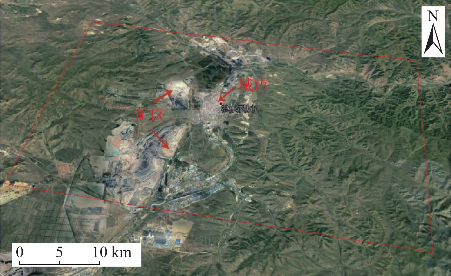
研究区霍林河煤田地处大兴安岭南段脊部,是一个山间盆地,四周为中低山峦所环抱 (图1),海拔标高1100 ~1350 m。盆地内部地势较平坦,东北和西南两端为低丘陵,中间区段是开扩的平原,海拔标高930 ~980 m。研究区内部包括中部与北部两个露天矿和霍林郭勒市市区。为了较好覆盖研究区,采用29景Sentinel 1 降轨数据及90 m分辨率Version4 SRTM数据,Sentinel 1数据具体参数如表1。
表 1 研究区SAR数据参数表Table 1. SAR data parameter table in the research area参数 Sentinel 1 幅宽/km 250 雷达波长/cm 5.6 空间分辨率/(m×m) 5×20 重访周期/d 12 影像数量/景
轨道号29149(降轨) 时间覆盖范围 2019-01-04—2019-12-30 2. 时序InSAR处理
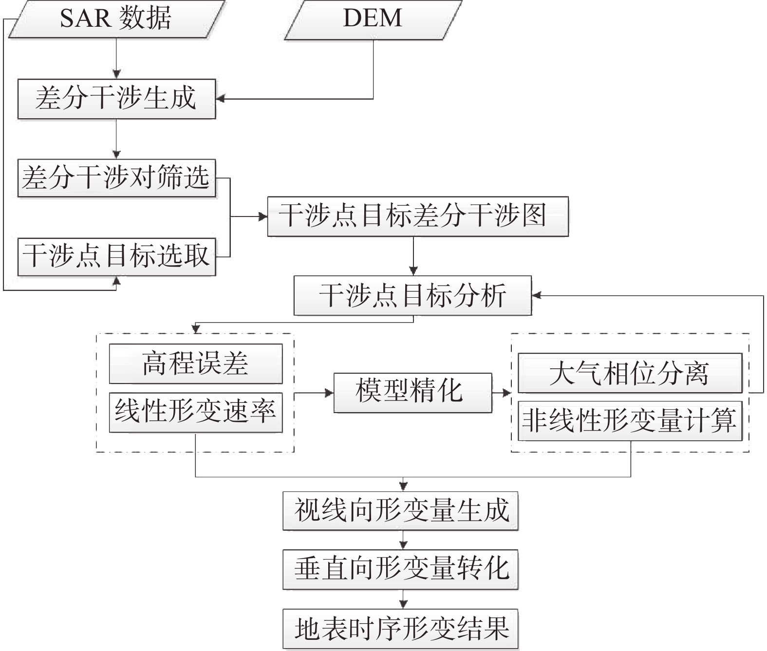
由于露天矿区及其城区周边地表相干性差异巨大,为保持矿区周边具备一定的相干性,采用改进的时序InSAR技术,该方法通过严格筛选差分干涉数据,对差分干涉数据提取分布式散射体与永久散射体,作为形变分析的目标点,通过进行回归分析与模型精化,得到研究区地表形变速率。改进的时序InSAR技术既继承了传统时序InSAR的技术优势,又很好的解决了目标研究区域相干性差异性较大的问题,具体技术流程如图2所示。
2.1 预处理与差分干涉图生成
通过GAMMA预先设置时间基线为30 d,空间基线为临界基线的30% 进行干涉生成,为了更好的筛选干涉数据[11-13],选用SRTM 数据除去差分干涉对原始的地形相位,通过对差分干涉数据的易发生形变区域进行目视分析比较剔除干涉效果差的像对,最后选择34个差分干涉结果进行后续试验处理,且为了保证低相干区域结果的准确性对9个相对组成的子集进行3D解缠,低相干地区参照3D解缠区域进行时序处理。筛选出部分的差分干涉结果如图3所示,6张差分干涉图在矿区位置都有明显的形变漏斗产生。
2.2 干涉点目标选取
由于矿区及其周边相干性较低,导致干涉结果较差,需要对矿区及其周边分布式目标点进行提取,文章提出经过参数优化的分布式散射点选取方法对研究区进行选点,主要包括以下三步:
(1)将同一区域分干涉结果像素数据进行时间维度平均,采用24×24窗口进行计算,将其中心区视为均值即为参考值,邻域像素值作为待估计值,为了减小误差,考虑空间临近关系,只把临近点像素作为待估计值[14]。
(2)运用瑞丽分布函数获得置信域区间,函数如式(1):
$$ \begin{array}{l}P \left\{ {\gamma }_{\text{ref}}-{\text{z}}_{{1}-\alpha /2}\cdot{0.52}\cdot{\gamma }_{\text{ref}}/\sqrt{N/L}< {\gamma }_{\text{arb}}<\right.\\ \left. {\gamma }_{\text{ref}}+{\text{z}}_{{1-}\alpha \text{/2}}\cdot\text{0}\text{.52}\cdot{\gamma }_{\text{ref}}\text{/}\sqrt{N/L}\right\}=1-\alpha \end{array} $$ (1) 式中:
$ {\gamma _{{\text{ref}}}} $ ——参考像素均值;$ {\gamma _{{\text{arb}}}} $ ——任意临近像素均值;${{\text{z}}_{{\text{1}}-\alpha {\text{/2}}}}$ ——标准正态分位点,服从标准正态分布,为 了增加同质点样本数量,$ \alpha $ 预先设置值 为50%;P——概率函数模型;
(3)为进一步提高样本选取精度,在小样本数据情况下,传统的高斯假设不能够逼近真实的分布,可以根据SAR强度服从指数分布的性质,其累加服从伽马分布,可以得到更加精确的置信域区间。
$$ f(x) = \frac{1}{\sigma }{e^{\textstyle\frac{x}{\sigma }}},x \geqslant 0 $$ (2) 式中,
$ \sigma $ 代表SAR强度指数分布的期望,根据伽马分布性质可知其分位点为$ {\text{2/}}\alpha $ ,在有N个样本的情况下,则可得置信域区间为:$$ \text{P}\left\{{G}_{\text{2/}\alpha:\text{N}} \cdot\sigma /N < {\gamma }_{\text{arb}} < {\text{G}}_{1-2/\alpha:\text{N}}\cdot\sigma /N\right\}=1-\alpha $$ (3) 将所有样本均值带入计算,提高同质样本的选取精度,进而得到分布式目标点。分布式目标(DS点)在干涉体系中占据大比例,包括裸漏的岩石、低矮植被等,对矿区选取DS点可以弥补永久散射体数量不足的缺点,避免失相干,进而提高干涉处理精度。
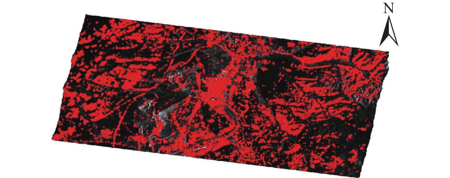
通过时序技术分别提取永久散射体点目标,将分布式点目标与永久散射体目标进行叠加(图4),采用Delaunay三角网法对两种相干目标点统一构网。差分干涉图中, 相邻目标点相位差表示为:
$$ \varphi {\text{ = }}\frac{{{{4}}{\textit{π}} }}{\lambda }{T_i}\Delta \upsilon + \frac{{4{\textit{π}} {B_ \bot }\Delta \varepsilon }}{{\lambda R\sin \theta }} + \Delta \omega $$ (4) 式中:
$\Delta \upsilon $ ——相邻点之间的形变速率;$\Delta \varepsilon $ ——高程误差;$\Delta \omega $ ——残余相位(包括大气延迟相位,非线性形变 相位和噪声相位);${B_ \bot }$ ——干涉对的空间基线;$T$ ——干涉对的时间基线;$\lambda $ ——波长;$R$ ——传感器到目标的距离;$\theta $ ——雷达入射角。2.3 干涉点目标形变处理
对目标点进行第一次回归分析时可以得到其高程误差、线性形变速率以及残余相位,由于第一次回归分析主要是为了估算初始的形变速率范围与数据处理效率,并没有顾及大气的与非线性形变相位的影响,因此在回归分析时,需要通过设置相位标准差小于1.5 rad 剔除质量较低的点,通过两次迭代可以使高程误差的趋近于0,标准差显著降低[17]。在虑性形变的条件下,形变速率增量以及高程误差增量通过整体相位相干系数最大化模型来进行模型优化,公式为:
$$ {\gamma _{i,j}} = \frac{1}{M}\left| {\sum\limits_{k = 1}^M {\exp (J\Delta \varphi _{i,j,res}^k)} } \right| = \max $$ (5) 其中,
$\gamma $ 越大,表示模型估计与差分相位越相似误差越小,以$\gamma $ 作为权重,使用带权的最小二乘方法,从已知参考点解算出稀疏格网上目标点的时序线性沉降速率$\upsilon $ 和高程误差$\varepsilon $ 。将解算的每个目标点的线性形变和高程误差从初始差分干涉图中减去, 即得到残余相位$\Delta \omega $ ,其包含了大气扰动相位、非线性形变相位以及噪声相位。再对点目标进行第二次回归分析,目的是使得非线性形变相位于大气延迟相位分离,因为大气延迟相位在1 km2范围内具有较强的空间相关性,在空间域上表现为平滑的低频信号,在时间域上呈现高频信号可被当作随机噪声处理[16-18]。因此根据其各自的特征进行合适的空间滤波,可将非线性形变相位和大气延迟相位分离,得到精确的非线性形变量。最后,根据计算的线性形变量和非线性形变量,得到形变相位进行相位并将其转到为形变量,视线向形变分解为垂直向形变。
3. 结果与分析
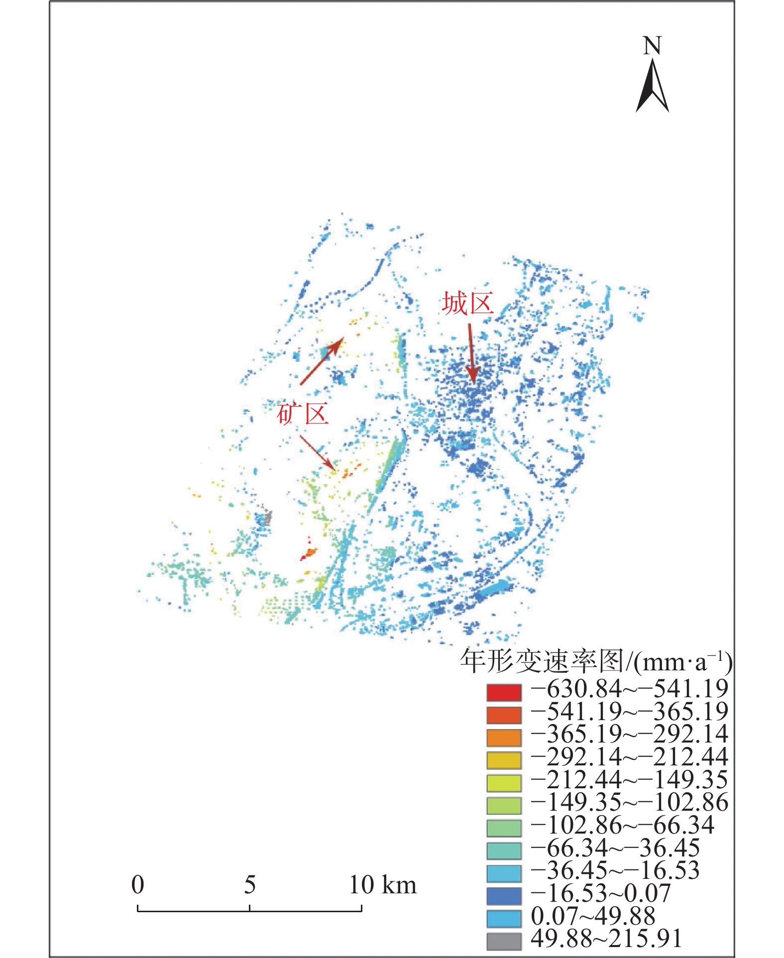
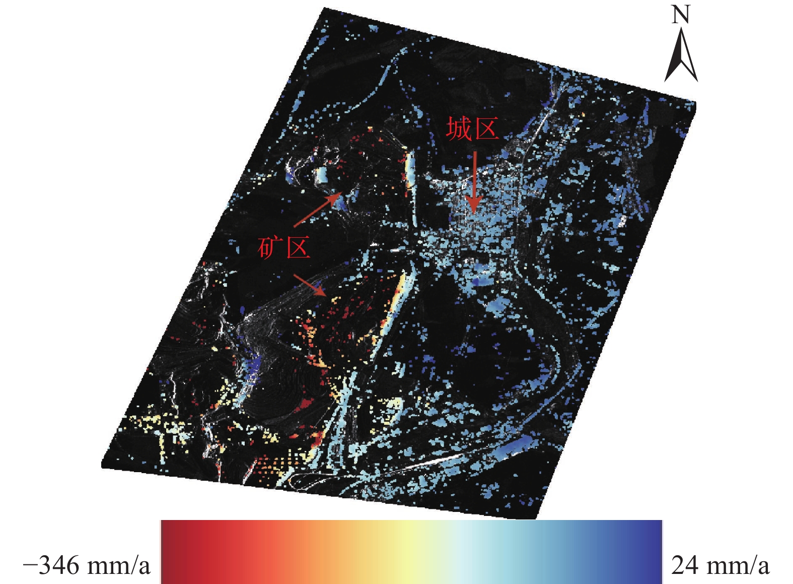
对时序InSAR结果进行区域裁剪,去除失相干区域,得到矿区及其周边城区的形变速率图与部分形变累积量如图5、图6,可得到在2019年全年中部露天矿区靠近城市侧的最大沉降速率达到569 mm/a,北部露天矿区远离城市侧最大沉降速率达到630 mm/a,中部露天矿附近城区地表最大沉降速率达到23 mm/a,北部露天矿附近城区地表最大沉降速率达到26 mm/a。由于露天矿区周边地质条件不稳定,露天矿旁道路年形变速率最大达到71 mm/a,城区的西侧沉降速率明显高于东侧。
3.1 地表形变及影响机理分析
矿区与城区之间地质条件不够稳定,最大沉降速率达到71 mm/a,平均沉降速率达到28 mm/a。试验区在1—3月平均沉降量5.3 mm、4—6月平均沉降量14.7 mm、7—9月平均沉降量16.2 mm、10—12月平均沉降量12.5 mm,其中4—6月和7—9月两个时间阶段沉降累积量较大。三个月为一组时间段,其平均沉降量、最大沉降量见表2。
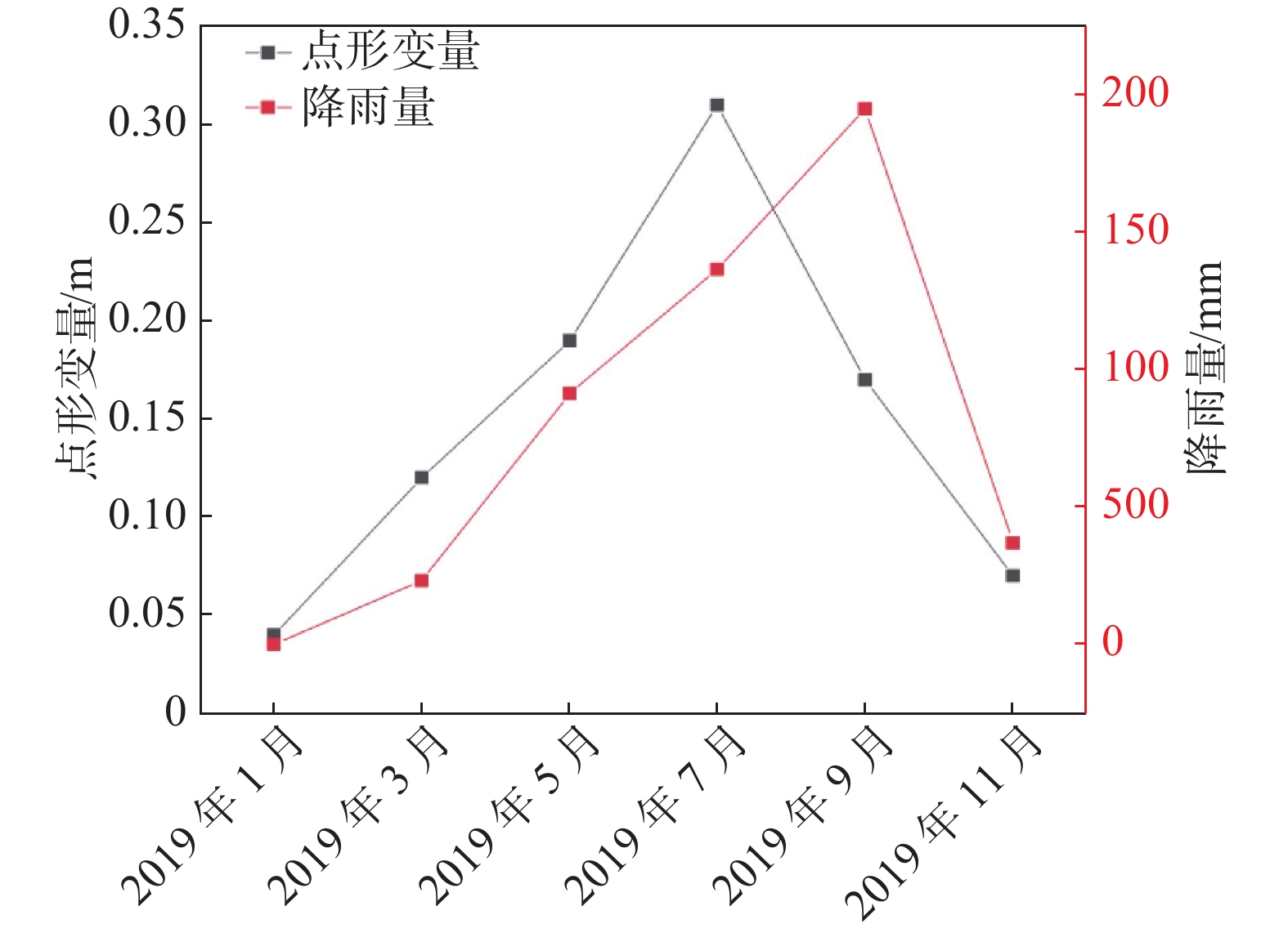
表 2 研究区累积沉降量表Table 2. Cumulative settlement scale1—3月 4—6月 7—9月 10—12月 平均沉降量/mm 5.3 14.7 16.2 12.5 最大沉降量/mm 31.3 46.5 264.7 36.7 4—6月形变量分析,中部露天矿最大沉降量达到57 mm,北部露天矿最大形变量达到54 mm,城区地表最大沉降量为4 mm。通过对降雨量的分析,霍林郭勒市4—6月降雨量与往年同期相比减少约30%,土地解冻是矿区沉降量剧增的主要因素。中部矿区西侧的地表形变量为正值,是由于矿区西侧地质条件不稳定和排土场堆弃排土所致。7—9月形变量分析,中部露天矿最大沉降量达到61 mm,北部露天矿最大沉降量达到59 mm,城市地表沉降量最大值达到12 mm。由于霍林郭勒市7—9月的降雨量与往年同期相比增加约50%,雨水可能导致地表沉降量增大,北部露天矿南侧地表形变量为正值,由于北部矿区开采排土场积土导致。对比上述两时间段形变量,可以看出中部与北部露天矿的南侧形变量均从由负值变为正值,均为排土堆砌所致,可以从矿区开采得到验证。采用Kenda系数法相关系数验证雨季时两者之间关系,经计算得系数为0.600,在夏季与秋季侵蚀性降雨与地表形变速率有正向的影响关系,可知在雨季降雨侵蚀力对露天矿坑周边地表环境变化产生较大影响,图7为侵蚀性降雨量与监测点形变量关系图。
由于矿区形变复杂,将像元值数目低于总数5%的剔除,并将形变速率图与强度影像进行叠加得到图8,可以看出,城区地表形变速率与其距离露天矿的距离成反比,即城区离露天矿越近地表的形变速率值越大,从客观上也符合矿业城市地表沉降的规律,城市并未出现大规模的不规则沉降,矿区与城市之间道路沉降值较大均在32 mm/a以上,靠近露天矿一侧的道路沉降值远大于另一侧,道路倾斜严重。
3.2 GPS数据验证与分析
为了验证改进得时序InSAR技术监测结果的精度,采用同期GPS结果进行比对。在图7上提取6个点并与同样的GPS点监测结果进行比较(表3),最小互差0.76,说明该InSAR监测方法是可行与可靠的。
表 3 GPS监测结果与同期InSAR监测结果比较Table 3. Comparison of GPS monitoring results with InSAR monitoring results in the same period点号 InSAR形变速率/(mm·a-1) GPS形变速率/(mm·a-1) 互差/(mm·a-1) A −12.46 −10.72 −1.74 B −31.27 −35.34 4.07 C −9.57 −5.39 −4.18 D −6.18 −8.42 2.24 E −16.73 −15.97 −0.76 F −26.49 −20.85 −5.64 4. 结 论
(1)考虑到露天矿区地表的低相干性,提出了一种改进的时序InSAR技术,采用24×24窗口同质样本选取方法提取分布式目标,最大化的识别矿区的相干点目标,对于霍林郭勒市城区采用经典的永久散射体干涉测量方法提取永久散射体,对两种干涉点目标进行统一的构网分析和形变反演,与GPS数据进行对比验证,证明改进的时序InSAR技术方法具有较好的监测效果,对矿业城市地表形变监测提出了一种新的InSAR监测方法。
(2)将霍林郭勒市的月降雨量数据和干涉点月沉降量关联分析,Kenda系数达到0.736证明二者具有较高相关性,可知侵蚀性降雨对于露天矿区及其周边地表沉降具有正向的影响。
(3)通过本方法得到露天矿区地表沉降速率最大可达346 mm/a,城区地表形变速率最大可达31 mm/a,露天矿和城区之间道路沉降量巨大,且公路两侧形变速率值差异巨大,道路出现明显的倾斜。剔除形变速率极值,可知城区地表形变速率从客观上符合矿业城市地表沉降的规律,即城区形变速率值与其到露天矿的距离成反比,可得城区并未出现大规模的不规则沉降,矿区与城市之间道路沉降值较大均在32 mm/a以上,靠近露天矿一侧的道路沉降值远大于另一侧,道路倾斜严重。
感谢欧洲空间局( ESA)为本文提供的SAR数据和国家科学数据服务平台提供SRTM-Version4数据。
-
表 1 研究区SAR数据参数表
Table 1 SAR data parameter table in the research area
参数 Sentinel 1 幅宽/km 250 雷达波长/cm 5.6 空间分辨率/(m×m) 5×20 重访周期/d 12 影像数量/景
轨道号29149(降轨) 时间覆盖范围 2019-01-04—2019-12-30 表 2 研究区累积沉降量表
Table 2 Cumulative settlement scale
1—3月 4—6月 7—9月 10—12月 平均沉降量/mm 5.3 14.7 16.2 12.5 最大沉降量/mm 31.3 46.5 264.7 36.7 表 3 GPS监测结果与同期InSAR监测结果比较
Table 3 Comparison of GPS monitoring results with InSAR monitoring results in the same period
点号 InSAR形变速率/(mm·a-1) GPS形变速率/(mm·a-1) 互差/(mm·a-1) A −12.46 −10.72 −1.74 B −31.27 −35.34 4.07 C −9.57 −5.39 −4.18 D −6.18 −8.42 2.24 E −16.73 −15.97 −0.76 F −26.49 −20.85 −5.64 -
[1] 姚佳明, 姚鑫, 陈剑, 等. 基于InSAR技术的缓倾煤层开采诱发顺层岩体地表变形模式研究[J]. 水文地质工程地质,2020,47(3):135 − 146. [YAO Jiaming, YAO Xin, CHEN Jian, et al. A study of deformation mode and formation mechanism of a bedding landslide induced by mining of gently inclined coal seam based on InSAR technology[J]. Hydrogeology & Engineering Geology,2020,47(3):135 − 146. (in Chinese with English abstract) [2] 任月龙, 李如仁, 张信. 基于多传感器网的露天矿边坡形变监测[J]. 煤炭学报,2014,39(5):868 − 873. [REN Yuelong, LI Ruren, ZHANG Xin. Open pit slope deformation monitoring based on multiple-sensors[J]. Journal of China Coal Society,2014,39(5):868 − 873. (in Chinese with English abstract) [3] 潘光永, 陶秋香, 陈洋, 等. 基于SBAS-InSAR的山东济阳矿区沉降监测与分析[J]. 中国地质灾害与防治学报,2020,31(4):100 − 106. [PAN Guangyong, TAO Qiuxiang, CHEN Yang, et al. Monitoring and analysis of sedimentation in Jiyang mining area of Shandong Province based on SBAS-InSAR[J]. The Chinese Journal of Geological Hazard and Control,2020,31(4):100 − 106. (in Chinese with English abstract) [4] BERARDINO P, FORNARO G, LANARI R, et al. A new algorithm for surface deformation monitoring based on small baseline differential SAR interferograms[J]. IEEE Transactions on Geoscience and Remote Sensing,2002,40(11):2375 − 2383. DOI: 10.1109/TGRS.2002.803792
[5] FERRETTI A, PRATI C, ROCCA F. Permanent scatterers in SAR interferometry[J]. IEEE Transactions on Geoscience and Remote Sensing,2001,39(1):8 − 20. DOI: 10.1109/36.898661
[6] 朱建军, 李志伟, 胡俊. InSAR变形监测方法与研究进展[J]. 测绘学报,2017,46(10):1717 − 1733. [ZHU Jianjun, LI Zhiwei, HU Jun. Research progress and methods of InSAR for deformation monitoring[J]. Acta Geodaetica et Cartographica Sinica,2017,46(10):1717 − 1733. (in Chinese with English abstract) DOI: 10.11947/j.AGCS.2017.20170350 [7] 刘一霖, 张勤, 黄海军, 等. 矿区地表大量级沉陷形变短基线集InSAR监测分析[J]. 国土资源遥感,2017,29(2):144 − 151. [LIU Yilin, ZHANG Qin, HUANG Haijun, et al. Monitoring and analyzing large scale land subsidence over the mining area using small baseline subset InSAR[J]. Remote Sensing for Land & Resources,2017,29(2):144 − 151. (in Chinese with English abstract) [8] 仝云霄, 黄岩, 陈宇, 等. D-InSAR矿区地表沉降监测及时空分析[J]. 测绘科学,2020,45(3):67 − 73. [TONG Yunxiao, HUANG Yan, CHEN Yu, et al. Surface subsidence monitoring and spatio-temporal analysis in mining area based on D-InSAR[J]. Science of Surveying and Mapping,2020,45(3):67 − 73. (in Chinese with English abstract) [9] 张学东, 葛大庆, 吴立新, 等. 基于相干目标短基线InSAR的矿业城市地面沉降监测研究[J]. 煤炭学报,2012,37(10):1606 − 1611. [ZHANG Xuedong, GE Daqing, WU Lixin, et al. Study on monitoring land subsidence in mining city based on coherent target small-baseline InSAR[J]. Journal of China Coal Society,2012,37(10):1606 − 1611. (in Chinese with English abstract) [10] 任文静, 贾洪果, 闫斌. SBAS-InSAR方法支持下的矿区地表沉降监测及参数反演[J]. 测绘通报,2021(3):113 − 117. [REN Wenjing, JIA Hongguo, YAN Bin. Monitoring and parameter inversion of ground subsidence in mining area based on SBAS-InSAR method[J]. Bulletin of Surveying and Mapping,2021(3):113 − 117. (in Chinese with English abstract) [11] 蒋金雄, 杜玉玲, 陈宇, 等. 利用DS-InSAR技术监测沛北矿区地表形变[J]. 测绘通报,2021(2):117 − 121. [JIANG Jinxiong, DU Yuling, CHEN Yu, et al. Monitoring and analysis of surface deformation in Peibei mining region based on DS-InSAR technique[J]. Bulletin of Surveying and Mapping,2021(2):117 − 121. (in Chinese with English abstract) [12] 谢文斌, 左小清, 刘玉忠, 等. 利用Sentinel-1A数据监测抚顺市地表形变[J]. 大地测量与地球动力学,2019,39(12):1270 − 1276. [XIE Wenbin, ZUO Xiaoqing, LIU Yuzhong, et al. Surface deformation monitoring of Fushun using sentinel-1A data[J]. Journal of Geodesy and Geodynamics,2019,39(12):1270 − 1276. (in Chinese with English abstract) [13] 蒋弥, 丁晓利, 李志伟. 时序InSAR同质样本选取算法研究[J]. 地球物理学报,2018,61(12):4767 − 4776. [JIANG Mi, DING Xiaoli, LI Zhiwei. Homogeneous pixel selection algorithm for multitemporal InSAR[J]. Chinese Journal of Geophysics,2018,61(12):4767 − 4776. (in Chinese with English abstract) DOI: 10.6038/cjg2018L0490 [14] 师芸, 李伟轩, 唐亚明, 等. 时序InSAR技术在地球环境监测及其资源管理中的应用: 以交城-清徐地区为例[J]. 武汉大学学报·信息科学版,2019,44(11):1613 − 1621. [SHI Yun, LI Weixuan, TANG Yaming, et al. Time series InSAR measurement for earth environmental monitoring and resource management: a case study of Jiaocheng-Qingxu area[J]. Geomatics and Information Science of Wuhan University,2019,44(11):1613 − 1621. (in Chinese with English abstract) [15] 范景辉, 郭华东, 郭小方, 等. 基于相干目标的干涉图叠加方法监测天津地区地面沉降[J]. 遥感学报,2008,12(1):111 − 118. [FAN Jinghui, GUO Huadong, GUO Xiaofang, et al. Monitoring subsidence in Tianjin area using interferogram stacking based on coherent targets[J]. Journal of Remote Sensing,2008,12(1):111 − 118. (in Chinese with English abstract) DOI: 10.11834/jrs.20080115 [16] 李鹏, 李振洪, 李陶, 等. 宽幅InSAR大地测量学与大尺度形变监测方法[J]. 武汉大学学报·信息科学版,2017,42(9):1195 − 1202. [LI Peng, LI Zhenhong, LI Tao, et al. Wide-swath InSAR geodesy and its applications to large-scale deformation monitoring[J]. Geomatics and Information Science of Wuhan University,2017,42(9):1195 − 1202. (in Chinese with English abstract) [17] 张路, 廖明生, 董杰, 等. 基于时间序列InSAR分析的西部山区滑坡灾害隐患早期识别: 以四川丹巴为例[J]. 武汉大学学报·信息科学版,2018,43(12):2039 − 2049. [ZHANG Lu, LIAO Mingsheng, DONG Jie, et al. Early detection of landslide hazards in mountainous areas of West China using time series SAR interferometry—A case study of Danba, Sichuan[J]. Geomatics and Information Science of Wuhan University,2018,43(12):2039 − 2049. (in Chinese with English abstract) [18] 崔潇, 周妍如, 刘孝阳, 等. 平朔露天煤矿复垦区不同地质层组岩土质量综合评价[J]. 水文地质工程地质,2021,48(2):164 − 173. [CUI Xiao, ZHOU Yanru, LIU Xiaoyang, et al. Comprehensive evaluation of rock and soil quality of different geological stratum groups in Pingshuo opencast coal mine reclamation area[J]. Hydrogeology & Engineering Geology,2021,48(2):164 − 173. (in Chinese with English abstract) -
期刊类型引用(7)
1. 杨华铨,柳金峰,孙昊,赵万玉,张文涛. 四川木里县项脚沟“7·5”特大型泥石流特征及发展趋势分析. 中国地质灾害与防治学报. 2024(01): 100-107 .  本站查看
本站查看
2. 王元欢,沈昊文,谢万银,鲁科,胡桂胜. 火后泥石流启动降雨阈值分析——以四川乡城县仁额拥沟泥石流为例. 中国地质灾害与防治学报. 2024(01): 108-115 .  本站查看
本站查看
3. 徐伟,郑玄,欧文,铁永波,付小麟,宋钰朋,殷万清. 四川凉山州地质灾害灾情特征与主要致灾类型. 中国地质灾害与防治学报. 2024(05): 78-89 .  本站查看
本站查看
4. 周瑞宸,胡卸文,金涛,曹希超,周永豪,张瑜. 重庆市2022年8月森林火灾火烧区特点及火后泥石流易发性评价. 水文地质工程地质. 2024(05): 150-160 .  百度学术
百度学术
5. 黄光林,胡卸文,席传杰,周瑞宸,何坤. 四川天全县白果树沟“7·15”泥石流成灾机理. 中国地质灾害与防治学报. 2024(06): 90-97 .  本站查看
本站查看
6. 陈宫燕,李婷,陈军,普布桑姆,阿旺卓玛,旺杰. 基于栅格径流汇流模拟的西藏林芝市泥石流灾害预警模型初探. 中国地质灾害与防治学报. 2023(01): 110-120 .  本站查看
本站查看
7. 张友谊,王云骏,袁亚东. 基于分形理论和模型试验的沟道物源动储量评价模型. 中国地质灾害与防治学报. 2022(05): 40-49 .  本站查看
本站查看
其他类型引用(1)


 下载:
下载:





 邮件订阅
邮件订阅 RSS
RSS