Risk assessment of geological hazards in Dingxi region of Gansu Province
-
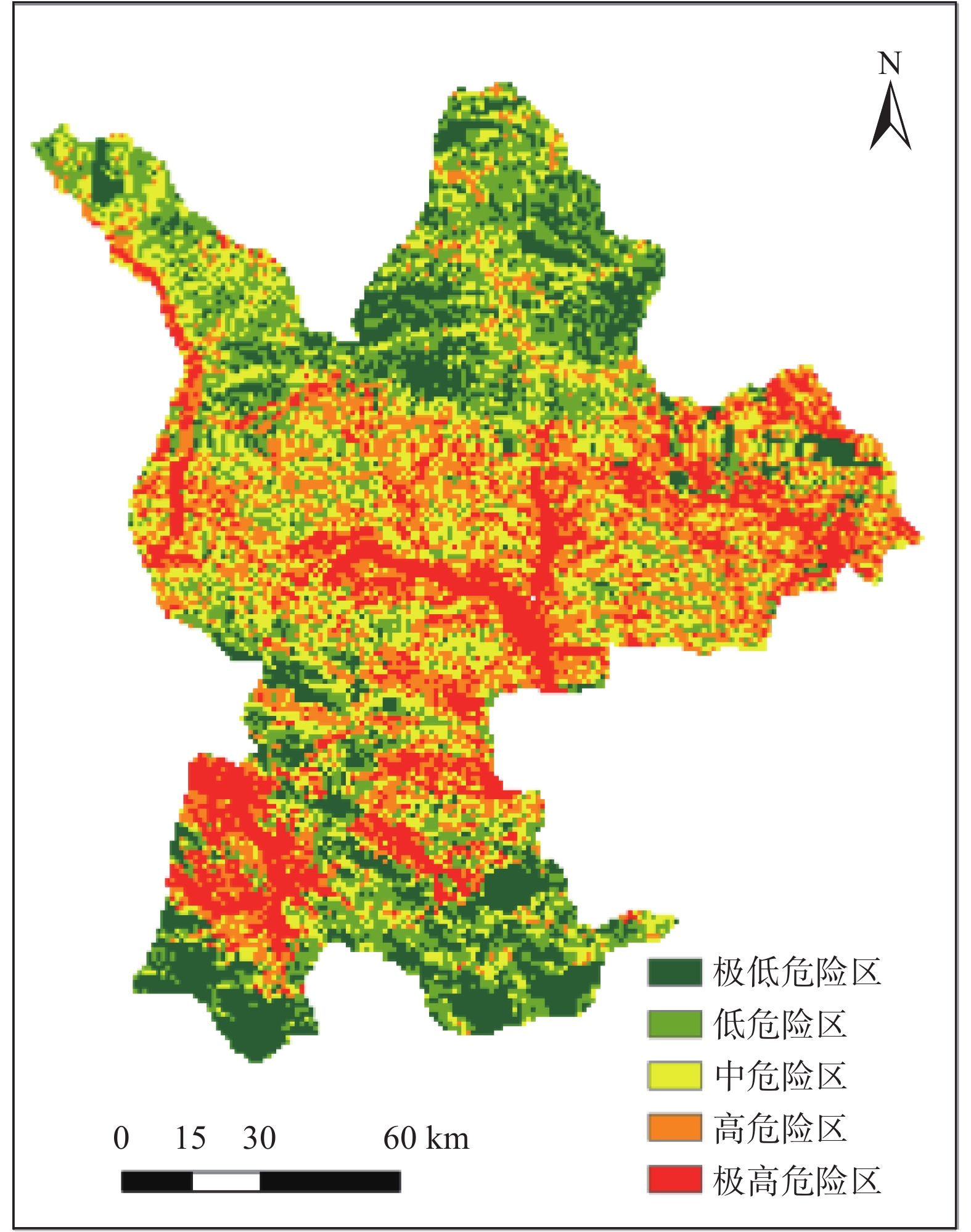
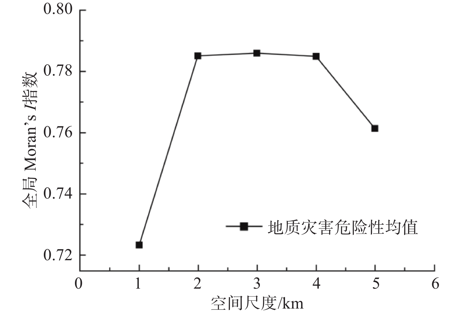
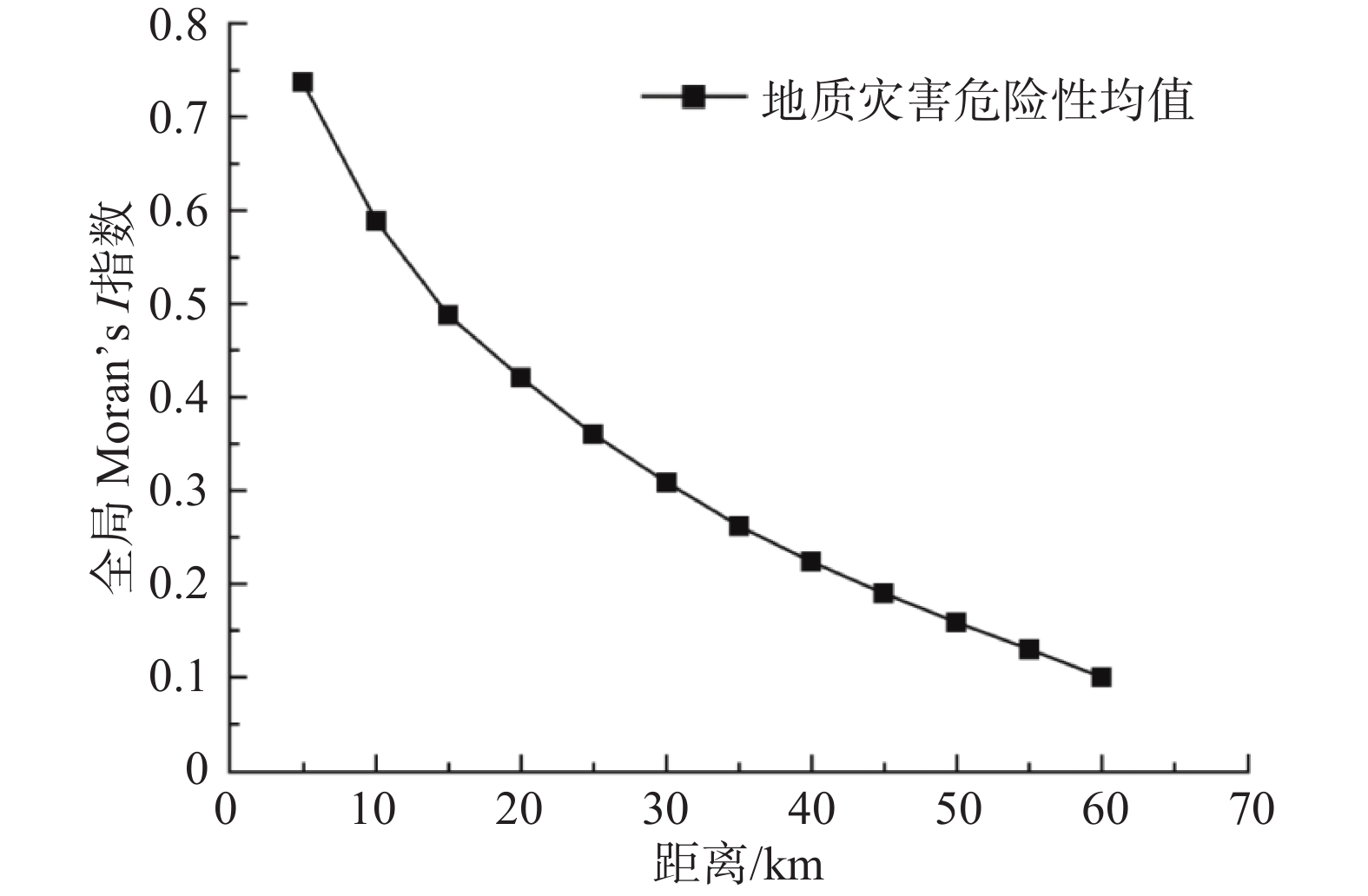
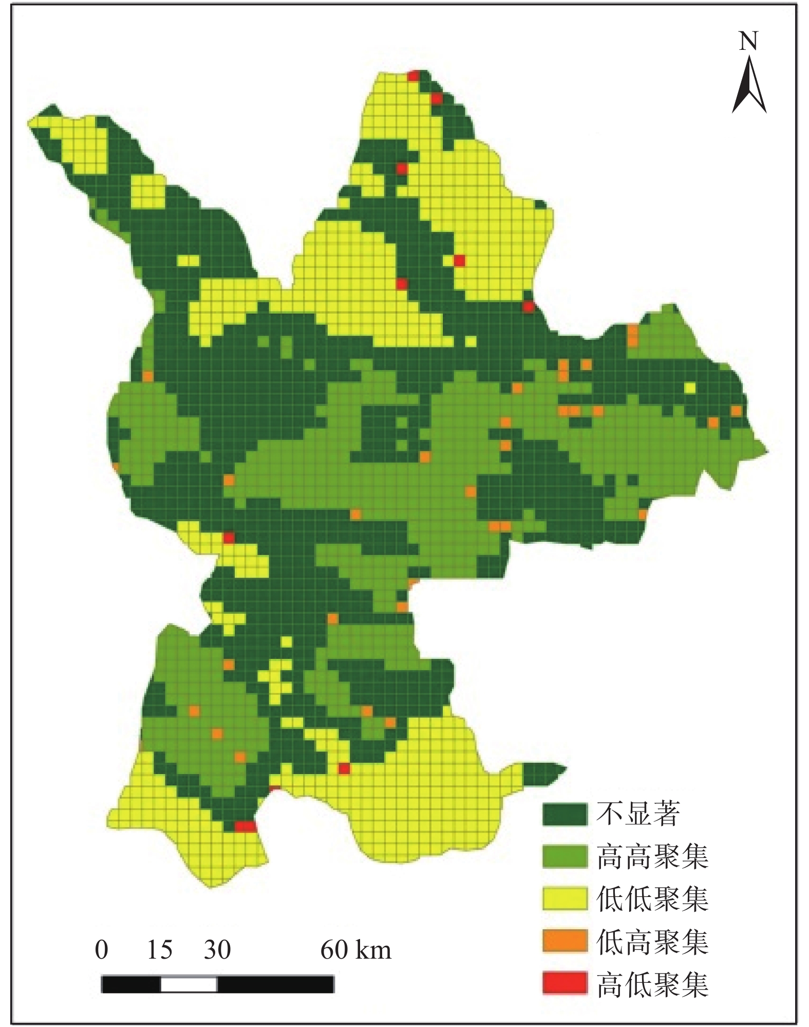
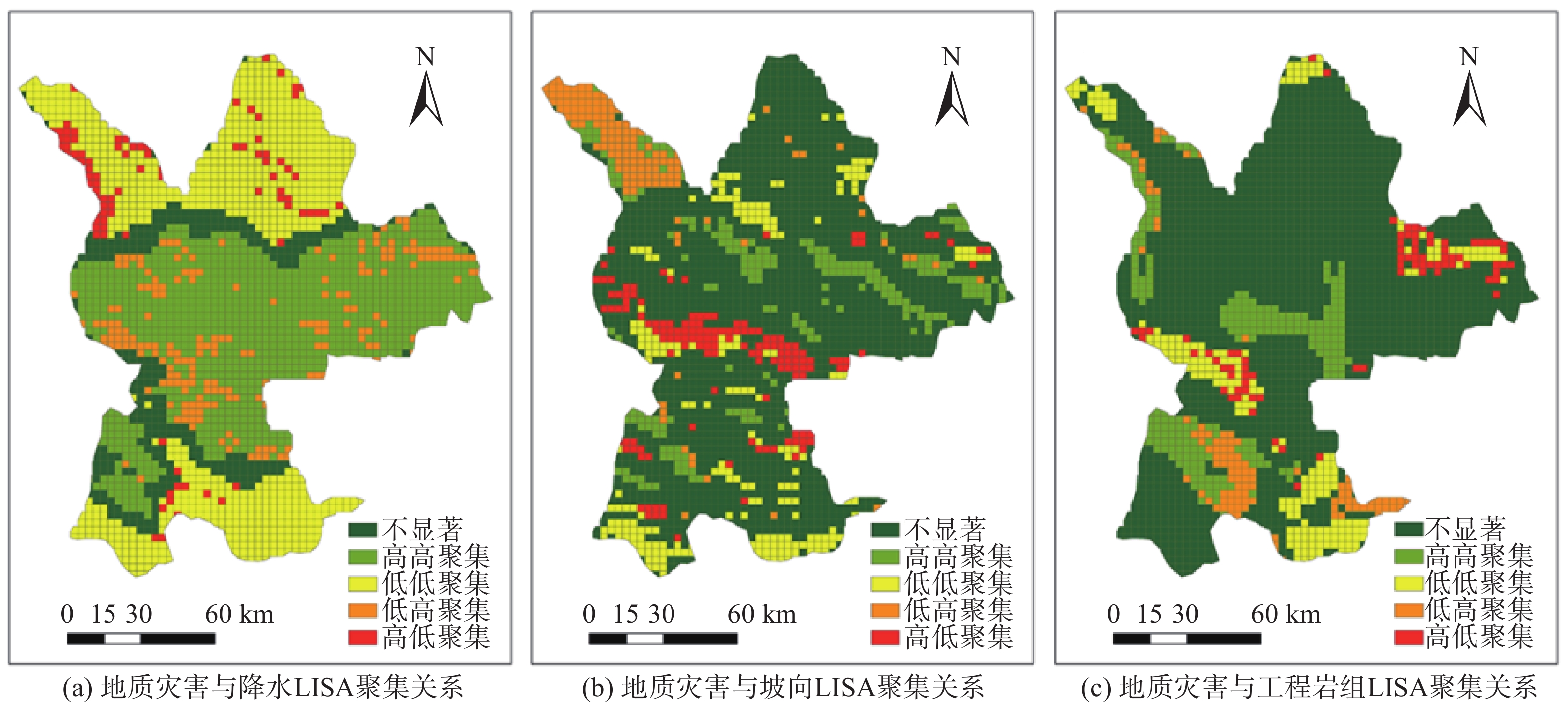
摘要: 识别地质灾害聚集的热点区及驱动力对于区域灾害预警具有重要意义。以甘肃定西地区为研究区,选取坡度、坡向、土地利用等7个评价因子,利用确定系数与逻辑回归耦合模型、空间自相关方法分析地质灾害的空间集聚特征及驱动因素。结果表明:定西地区地质灾害危险性呈现中部高,南北两侧低的特征,其主要受降水、坡向、工程岩组等因子的影响;地质灾害与降水、坡向和工程岩组的空间关系为高高聚集;地质灾害危险性存在较强的空间自相关性,在3 km的空间尺度上呈显著正相关,且随距离阈值增加而降低;距离阈值为5 km时,正相关高高聚集与低低聚集以团块的形式存在,而高低聚集与低高聚集多以零星状分布。研究可为区域地质灾害监测与防控提供参考。Abstract: It is of great significance to identify the hot spots and driving forces of geological hazard gathering for regional disaster early warning. Dingxi region of Gansu Province is taken as a the study area. Seven factors such as slope, aspect, land use, engineering rock group and so on are selected to analyze the spatial agglomeration characteristics and driving factors of geological hazards by using coupling model of determining coefficient and logical regression and spatial autocorrelation. The results show that the sensitivity of geological hazards in Dingxi region is high in the middle region and low in the north and south region. The spatial relationship between geological hazards and precipitation, aspect and engineering rock group is high accumulation. Geological hazard sensitivity has strong spatial autocorrelation, which is significantly positive correlation in 3 km scale, and decreases with the increase of distance threshold. When the distance threshold is 5 km, the high and low aggregation areas are clustered and distributed in the form of clumps, while the high and low aggregation areas and the low and high aggregation areas are mostly scattered. The research can provide reference for regional geological hazard monitoring and control.
-
0. 引言
冻土是指温度低于0 ℃,且含冰的岩土,其由水、冰、气体和固体矿物颗粒组成[1]。它是一种多相体系,其性质受未冻水含量和含冰量的控制,而含冰量的多少会随温度的变化而变化。因此冻土是一种不同于普通土的特殊土体。我国冻土分布面积广大,永久性和季节性冻土面积约占全国陆地总面积的2/3,冻土主要分布在我国西北和纬度较高的东北部地区[2]。随着“一带一路”国家战略的进一步推进,西部地区将建设许多重大工程项目。这些工程在低温作用下不可避免的会产生冻害问题,比如水平冻胀力造成支挡结构和输水渠道的破坏,冻胀造成公路路面开裂、造成铁路轨面不平顺,这些问题都是冻土地区工程建设所要面对的挑战,因此对冻土、土体水平冻胀力的发展及其危害等问题进行深入研究显得尤为重要。
EIGENBROD[3]研究发现土体的体积会随着冻融循环次数的增加而增大,但后期会慢慢趋于稳定。李岩等[4]利用大型三维模拟冻结试验系统,对竖向直排冻结条件下不同深度土体的水平冻胀力分布特性进行了试验研究。刘鸿绪等[5-6]在冻胀力学方面做了大量的研究,指出法向冻胀力的大小与地表的总冻胀量无关,地表的总冻胀量是整个冻结深度范围内土体冻胀率线性叠加的宏观表现,还提出土体在冻结过程中,首先产生水平冻胀压应力,然后该压应力逐渐减小并变为冻缩温度拉应力。孙彦福等[7]认为在季节冻结层和季节融化层之间存在水平冻胀力,根据水平冻胀力与冻结锋面的关系将其分为平行水平冻胀力和垂直水平冻胀力,并提出水平冻胀力有其发生、发展及消退的独特规律。姜龙等[8]通过室内冻结试验研究了温度、含水量、干密度和冻胀率等因素与法向冻胀力的关系并且分析了土体上覆荷载对土体冻胀的影响。胡坤等[9]通过大量一维冻胀试验研究了不同约束条件下土体水分场、冻胀量、冻胀率和冻胀力的变化规律以及土体冻胀量与冻胀力之间的关系。王建州等[10]通过室内模型试验研究了季冻区越冬深基坑在冻结-融化过程中水平冻胀力的变化规律。吕长霖[11]通过自行研制的一维冻胀试验系统,研究了不同水平约束刚度和竖向荷载条件下冻胀敏感性土的冻胀规律以及水平冻胀力。VINSON等[12]和LING等[13]研究了含水率对冻结土体动态特性的影响。
国内外学者对土体冻胀机理、冻胀特性、法向冻胀力的发展规律、冻害治理措施和冻害预测模型做了大量的研究,发现了大量规律并提出了许多理论。但对一维冻结条件下水平冻胀力的发展研究较少,通过室内模型试验研究水平冻胀力变化的报道也比较少。在我国黄土地区,既有普速铁路在建设时修筑了大量素黄土路基,由于黄土特殊的物理力学性质造成部分路基的冻害比较严重,由于维修天窗时间的限制冻害线路处理和维修的难度较大。本文以季节性冻土区黄土路基为研究对象,采用室内模型试验方法,研究了路基在一维冻结过程中土体温度和水平冻胀力的变化规律,给出了土体温度的变化曲线,水平冻胀力与时间之间的关系。以期通过不同含水率条件下黄土一维冻胀试验来探索黄土路基冻胀灾害防治的有效措施和方法。
1. 模型试验
1.1 材料性质
试验土料取自甘肃省兰州市九州台地区,基本物理指标依据《铁路工程土工试验规程》[14]中的相关规定进行,试验测得其基本物理指标如表1所示。
表 1 黄土基本物理指标Table 1. Basic physical properties of loess比重
Gs液限
wL/%塑限
wp/%塑性指数
Ip最优含水率
wopc/%最大干密度
ρdmax/(g·cm−3)2.71 28.38 15.21 13.17 13.6 1.89 1.2 试验装置
试验采用单向封闭冻结试验系统,试验系统可以按照试验要求控制温度,该系统由温度控制系统、环境箱和模型箱、测量系统3部分组成(图1)。
温度控制系统使用杭州雪中炭恒温技术有限公司生产的低温恒温循环器,其输出温度范围为−30 ℃~+50 ℃,精度0.2 ℃,循环液使用无水乙醇。
使用试验室环境箱其尺寸为2 m×2 m×1.8 m。模型箱由角钢和有机玻璃制成,尺寸为0.8 m×0.6 m×0.8 m,侧壁和底部均粘贴保温棉。
测量系统包括:(1)水平冻胀力的测量:使用定制的微型土压力盒,其外形尺寸为Φ30 mm×9 mm,量程为200 kPa,精度为±0.5%,为了使水平冻胀力测量准确,埋设土压力盒时保证其正面与模型箱壁严格平行,土压力盒均居中布置;(2)温度的测量:温度测量采用铂热电阻pt100,其工作范围:−50~+200 ℃,精度为0.1 ℃。温度测量传感器的埋设位置和微型土压力盒在相同深度并且错开一定的水平距离,土体从上表面开始沿深度每隔12 cm设置一个;(3)数据采集:使用32通道静态应变采集仪,LCXAF温度巡检仪和安装相关采集软件的计算机。为保证试验数据的准确与可靠性,温度和冻胀力测量传感器均布设了两个断面(图2)。
1.3 试验技术路线
本研究采用闭式一维冻胀模型试验系统,来模拟冷源单向冻结条件。试验过程中记录温度场和水平冻胀力的变化数据。试验中土体的含水率分别为14%、16%和20%,压实度为0.9,研究采用封闭系统,环境箱温度为−20 ℃。在模型箱和环境箱之间的空隙中填充保温棉,由于其导热系数很小,可以认为试验设备的温度边界条件能满足试验设计的一维冻结条件。为了模拟自然条件下的排水边界条件,模型箱底部铺5 cm中粗砂。按照试验方案将拌和均匀的土分层填入模型箱,填土过程中将温度传感器和土压力盒按照试验要求安装在相应位置,填筑完成后对箱内土体进行补水,然后将箱内土体静置72 h,使土体中水分分布均匀。开启低温环境试验箱的温度控制系统,设置控制温度为−20 ℃,对模型进行降温冻结并定期检查所采集的数据。当土体温度下降到试验方案的设计值时,停止冻结。设置控制温度为20 ℃来模拟融化过程。填筑完成后的模型如图2所示。
2. 试验结果分析
2.1 温度场
图3为一个冻融循环周期试验过程中土体不同深度处温度的变化曲线。以土体含水率14%、16%和20%的结果为例进行说明,环境箱内的环境温度在试验开始25 h后达到试验所设定的温度并且基本稳定。试验进行320 h后由冻结阶段转变为融化阶段,环境温度快速上升到试验设定的温度。由温度变化曲线可以看出,距离土体表面越远温度曲线就越对称,降温速率相近。靠近表面的点,土体冻结和融化过程曲线差异较大,升温的速率大于降温的速率并且在0.4 ℃出现转折,降温阶段的温度变化速率0.051 ℃/h,升温阶段的温度变化速率0.1558 ℃/h。
温度变化到0.4 ℃处时较深处的土体降温速率出现一个平稳阶段,降温曲线基本平行于横坐标,并且在降温和升温两个阶段表现出很强的对称性。造成这一现象的主要原因是土体中的水分释放相变潜热,并且含水率越高这种现象越明显。冻结后期(土体温度从0.4 ℃下降到试验降温结束)各深度处土体的温度下降速率较慢,这主要是土体冻结后土体导热系数和比热容发生了变化。含水率不同的土体温度变化规律相似,土体不同深度处的升温过程与降温阶段对称。
2.2 水平冻胀力
土体冻结过程中,随着土体温度的逐渐降低土中的液态水变为冰(固态水),未冻水含量减少,土体含冰量增加,同时伴随着土体体积逐渐增大,并且土体产生冻胀位移和冻胀力。一个冻融循环周期土体水平冻胀力与冻结时间的关系如图4所示。由图可知,当温度降低到起始冻结温度时土体开始产生水平冻胀力,起始冻胀力为0.6 ℃;随着环境箱内的温度进一步的降低,水平冻胀力快速增长并达到最大值,土体某一点最大水平冻胀力对应的温度称为最大冻胀力温度:然后温度继续下降时水平冻胀力逐渐减小:随着温度的进一步降低,水平冻胀力出现负值。当温度开始回升时水平冻胀力有波动增大的趋势。距离表面为12 cm处的土地冻结150 h后土地开始出现水平冻胀力,水平冻胀力先逐渐增加并出现最大值,冻结260 h之后水平冻胀力然后逐渐减小。
根据曲线变化趋势,可将一个冻融循环过程中水平冻胀力的变化分为4个区段:①土体温度在−0.6 ℃以上基本不产生水平冻胀力;②当土体温度下降到−0.6 ℃时水平冻胀力开始增长,当土体温度下降到某一温度(最大冻胀力温度)时水平冻胀力出现最大值,不同含水率的土体出现冻胀力最大值的温度不同;③土体温度低于最大冻胀力温度后,土体中水平冻胀力逐渐降低;④融化阶段当土体温度开始升高时水平冻胀力产生波动,又进一步有所增大。
在封闭一维冻结条件,随着环境箱温度下降,土体温度也逐渐降低,当土体温度降至起始冻结温度后,含水量超过起始冻胀含水量的土体将会产生冻胀并且在水平方向出现水平冻胀的内应力。此时,在垂直方向由于土体表面是无约束的,因而会产生冻胀量。当土体温度继续降低土体中的未冻水大部分会逐渐冻结转化为固态的冰,在此期间冻胀过程基本完成,水平冻胀力达到最大值。当土体温度继续降低时,由于土体中未冻水含量较少因而产生的冻胀很小,土颗粒的降温收缩的效果将会大于未冻水冻结而产生的体积增大,土体收缩会使水平冻胀力逐渐减小;土体降温至某一温度值水平冻胀力则会减小到零,此时土中水由于冻结而增大的体积和土颗粒由于冷缩减小的体积相等;土体温度继续降低水平冻胀力出现负值,由于土压力盒不能测量拉应力,理论上负值的水平冻胀力的量值最大等于土体冻结前的土压力。
最大水平冻胀力沿深度的分布如图5所示,由图可知,最大水平冻胀力的量值在0~24 cm处相对稳定,变化较小,在36~48 cm处出现最大值。总体趋势沿着土体深度先是较为稳定,数值变化较小;然后增大出现最大值最后减小。水平冻胀力最大值随含水率有很明显的变化,而其它值的大小受含水率的影响较小。水平冻胀力最大值出现在相对深度0.6~0.8处,含水率为14%的土体最大水平冻胀力为15.46 kPa,含水率16%的土体为22.69 kPa,含水率20%的土体为25.12 kPa。
2.3 水平冻胀力、土体温度和环境温度之间的关系
为了更方便的分析水平冻胀力、土体温度和环境温度之间的关系,以土体含水率为14%试验中深度36 cm的数据为例绘制图6,环境温度可以很快达到设定温度,水平冻胀力在土体温度低于0.6 ℃时开始产生,随着土体温度降低水平冻胀力逐渐增大并出现最大值,然后土体温度继续降低时水平冻胀力减小;融化阶段,当土体温度高于0.6 ℃时水平冻胀力有一定的波动变化。
2.4 含水率对温度和水平力的影响
影响土体冻胀特性的因素有:土质、含水率、温度和压实度等。而在相同的土质条件下,含水率则是冻胀的主要影响因素。本研究分别进行了不同含水率的试验,结果如图5和图6所示。试验结果表明,不同含水率土体的温度和水平冻胀力的变化规律相似,含水率越高的土体降温速率就越快,不同含水率土体的最大水平冻胀力不同,含水率越高土体水平冻胀力越大。
3. 结论
通过室内闭式一维冻胀模型试验研究了兰州地区黄土的温度场及冻胀力的变化规律,主要结论如下:
(1)土体不同深度处的降温过程可分为三个阶段,降温冻结初期各深度土体的温度下降速率较快;土体温度下降到0.4 ℃时降温曲线出现转折点,土层各深度降温速曲线出现近乎平行于横坐标的平稳段,并且含水率越高这种现象越明显;冻结后期各深度土体的温度下降速率较慢。土体不同深度处的升温过程与降温过程曲线对称。
(2)冻胀力变化曲线按照变化趋势分为三个阶段:稳定不发展阶段,增长阶段,减小阶段,不同含水率土体经历各阶段的时间有所不同。
(3)在相同土质和温度条件下冻胀力发展的起始温度相同,含水率不同的土体最大冻胀力温度不同。
(4)最大水平冻胀力沿着土体深度先较为稳定,然后增大最后减小,最大值出现在相对深度0.6−0.8处。
(5)水平冻胀力在土体温度低于0.6 ℃时开始产生,随着土体温度降低水平冻胀力逐渐增大并出现最大值,然后土体温度继续降低时水平冻胀力减小。
-
表 1 定西地区各个县地质灾害点数量
Table 1 Dingxi region each county geological disaster point number
滑坡/处 崩塌/处 泥石流/处 安定区 10 6 19 通渭县 22 35 2 陇西县 31 31 34 漳县 2 0 50 临洮县 23 3 20 渭源县 21 6 11 岷县 9 0 83 表 2 各因子CF值计算结果
Table 2 Calculation result of CF value of each factor
评价因子 类别量 灾害点数 CF 评价因子 类别量 灾害点数 CF 坡度/(°) 0~8 108 0.124 坡向 北 31 −0.472 8~16 162 −0.051 东北 48 −0.277 16~24 103 −0.023 东 45 −0.175 >24 45 −0.050 东南 69 0.331 降水量/mm <330 26 −0.327 南 66 0.219 330~380 43 −0.420 西南 77 0.320 380~430 193 0.193 西 44 −0.000 430~480 125 0.315 西北 38 −0.140 >480 31 −0.514 距河流距离/m 0~2000 84 0.243 土地利用 林地 20 −0.535 2000~4000 63 0.208 草地 194 −0.086 4000~6000 61 0.177 湿地 5 0.655 6000~8000 49 0.108 耕地 179 0.148 8000~10000 37 −0.141 人工表面 17 0.559 >10000 131 −0.250 未利用地 4 0.498 距道路距离/m <500 79 0.337 工程岩组 侵入岩 3 −0.805 500~1000 81 0.242 喷出岩 1 −0.378 1000~1500 23 −0.027 变质岩 63 0.188 1500~2000 28 −0.129 碎屑岩 311 −0.007 2000~2500 30 0.218 碳酸岩 19 −0.250 >2500 184 −0.207 松散岩 22 0.439 表 3 逻辑回归分析结果
Table 3 Results of logical regression analysis
B SE Wals df sig 坡度 −3.284 1.255 6.852 1 0.009 坡向 1.506 0.313 23.199 1 0.000 降水 1.766 0.267 43.704 1 0.000 土地利用 1.305 0.433 9.092 1 0.003 工程岩组 2.458 0.606 16.444 1 0.000 距河流距离 0.940 0.940 5.368 1 0.021 距道路距离 1.110 0.393 7.981 1 0.005 常数项 0.066 0.086 0.593 1 0.441 注:B代表各因子的回归系数,SE为标准误差,Wals为卡方值,df为自由度,sig表示显著性。 表 4 地质灾害危险性分区统计表
Table 4 Zonal statistical table of geological hazard
敏感性等级 极高
危险区高
危险区中
危险区低
危险区极低
危险区该级别区域面积/km2 3089 4258 4590 4368 3030 占研究区面积比/% 15.98 22.02 23.74 22.59 15.67 灾害点个数 135 124 100 47 12 占灾害样本点总数比/% 32.30 29.67 23.92 11.24 2.87 -
[1] 唐川, 马国超. 基于地貌单元的小区域地质灾害易发性分区方法研究[J]. 地理科学,2015,35(1):91 − 98. [TANG Chuan, MA Guochao. Small regional geohazards susceptibility mapping based on geomorphic unit[J]. Scientia Geographica Sinica,2015,35(1):91 − 98. (in Chinese with English abstract) [2] 牛全福, 陆铭, 李月锋, 等. 基于灰色关联与粗糙依赖度的甘肃兰州市区泥石流危险性评价[J]. 中国地质灾害与防治学报,2019,30(5):48 − 56. [NIU Quanfu, LU Ming, LI Yuefeng, et al. Hazard assessment of debris flow in Lanzhou City of Gansu Province based on methods of grey relation and rough dependence[J]. The Chinese Journal of Geological Hazard and Control,2019,30(5):48 − 56. (in Chinese with English abstract) [3] 张晓东, 刘湘南, 赵志鹏, 等. 基于层次分析法的盐池县地质灾害危险性评价[J]. 国土资源遥感,2019,31(3):183 − 193. [ZHANG Xiaodong, LIU Xiangnan, ZHAO Zhipeng, et al. Geological disaster hazard assessment in Yanchi County based on AHP[J]. Remote Sensing for Land Resources,2019,31(3):183 − 193. (in Chinese with English abstract) [4] 孙长明, 马润勇, 尚合欣, 等. 基于滑坡分类的西宁市滑坡易发性评价[J]. 水文地质工程地质,2020,47(3):173 − 181. [SUN Changming, MA Runyong, SHANG Hexin, et al. Landslide susceptibility assessment in Xining based on landslide classification[J]. Hydrogeology & Engineering Geology,2020,47(3):173 − 181. (in Chinese with English abstract) [5] 宁娜, 马金珠, 张鹏, 等. 基于GIS和信息量法的甘肃南部白龙江流域泥石流灾害危险性评价[J]. 资源科学,2013,35(4):892 − 899. [NING Na, MA Jinzhu, ZHANG Peng, et al. Debris flow hazard assessment for the Bailongjiang river, southern Gansu[J]. Resources Science,2013,35(4):892 − 899. (in Chinese with English abstract) [6] 刘明学, 陈祥, 杨珊妮. 基于逻辑回归模型和确定性系数的崩滑流危险性区划[J]. 工程地质学报,2014,22(6):1250 − 1256. [LIU Mingxue, CHEN Xiang, YANG Shanni. Zonation of landslide risk with logistic regression model and certainty factor[J]. Journal of Engineering Geology,2014,22(6):1250 − 1256. (in Chinese with English abstract) [7] 许冲, 戴福初, 姚鑫, 等. 基于GIS与确定性系数分析方法的汶川地震滑坡易发性评价[J]. 工程地质学报,2010,18(1):15 − 26. [XU Chong, DAI Fuchu, YAO Xin, et al. GIS platform and certainty factor analysis method based Wenchuan earthquake-induced landslide susceptibility evaluation[J]. Journal of Engineering Geology,2010,18(1):15 − 26. (in Chinese with English abstract) DOI: 10.3969/j.issn.1004-9665.2010.01.003 [8] 田春山, 刘希林, 汪佳. 基于CF和Logistic回归模型的广东省地质灾害易发性评价[J]. 水文地质工程地质,2016,43(6):154 − 161. [TIAN Chunshan, LIU Xilin, WANG Jia. Geohazard susceptibility assessment based on CF model and Logistic Regression models in Guangdong[J]. Hydrogeology & Engineering Geology,2016,43(6):154 − 161. (in Chinese with English abstract) [9] 李慧, 王云鹏, 李岩, 等. 珠江三角洲土地利用变化空间自相关分析[J]. 生态环境学报,2011,20(12):1879 − 1885. [LI Hui, WANG Yunpeng, LI Yan, et al. A spatial autocorrelation analysis of land use change in Pearl River Delta[J]. Ecology and Environmnet,2011,20(12):1879 − 1885. (in Chinese with English abstract) DOI: 10.3969/j.issn.1674-5906.2011.12.017 [10] 刘金雅, 汪东川, 孙然好, 等. 基于变化轨迹分析方法的生态用地流失空间关联研究[J]. 地理研究,2020,39(1):103 − 114. [LIU Jinya, WANG Dongchuan, SUN Ranhao, et al. Study on spatial relevance of ecological-land loss based on change trajectory analysis method[J]. Geographical Research,2020,39(1):103 − 114. (in Chinese with English abstract) DOI: 10.11821/dlyj020181021 [11] 林金煌, 张岸, 邓超, 等. 闽三角城市群地质灾害敏感性评价[J]. 地球信息科学学报,2018,20(9):1286 − 1297. [LIN Jinhuang, ZHANG An, DENG Chao, et al. Sensitivity assessment of geological hazards in urban agglomeration of Fujian delta region[J]. Geo-Information Science,2018,20(9):1286 − 1297. (in Chinese with English abstract) DOI: 10.12082/dqxxkx.2018.180099 [12] 中国地质环境监测院编制. 中国典型县 (市) 地质灾害易发程度分区图集 [M]. 北京: 科学出版社, 2011. China Institute of Geological Environment Monitoring. Atlas of geological hazard susceptibility in typical counties (cities) in China [M]. Beijing: Science Press, 2011. (in Chinses)
[13] 覃伟, 徐智彬, 李东林. 渗透性与降雨强度对堆积层滑坡稳定性的影响[J]. 地质与勘探,2016,52(4):743 − 750. [QIN Wei, XU Zhibin, LI Donglin. Controls of permeability and rainfall intensity on accumulation landslide stability[J]. Geology and Prospecting,2016,52(4):743 − 750. (in Chinese with English abstract) [14] 张欣, 王运生, 梁瑞锋. 基于GIS的小江断裂中北段滑坡灾害危险性评价[J]. 地质与勘探,2018,54(3):623 − 633. [ZHANG Xin, WANG Yunsheng, LIANG Ruifeng. Assessment of landslide hazard in the middle and northern Xiaojiang fault zone based on GIS[J]. Geology and Prospecting,2018,54(3):623 − 633. (in Chinese with English abstract) [15] 谭玉敏, 郭栋, 白冰心, 等. 基于信息量模型的涪陵区地质灾害易发性评价[J]. 地球信息科学学报,2015,17(12):1554 − 1562. [TAN Yumin, GUO Dong, BAI Bingxin, et al. Geological hazard risk assessment based on information quantity model in Fuling district, Chongqing City, China[J]. Geo-Information Science,2015,17(12):1554 − 1562. (in Chinese with English abstract) [16] 裴惠娟, 陈晋, 李雯, 等. 甘肃省地质灾害风险评估[J]. 灾害学,2017,32(2):97 − 102. [PEI Huijuan, CHEN Jin, LI Wen, et al. Geological disaster risk assessment in Gansu Province[J]. Journal of Catastrophology,2017,32(2):97 − 102. (in Chinese with English abstract) DOI: 10.3969/j.issn.1000-811X.2017.02.017 [17] 冯磊, 孙保平, 康苗. 甘肃省定西市安定区土壤侵蚀潜在危险度评价及侵蚀背景空间分析[J]. 吉林农业科学,2012,37(4):25 − 29. [FENG Lei, SUN Baoping, KANG Miao. Appraisal and study on potential danger of soil erosion and spatial analysis on erosion background in Anding region, Dingxi City of Gansu Province[J]. Jilin Agricultural Sciences,2012,37(4):25 − 29. (in Chinese with English abstract) DOI: 10.3969/j.issn.1003-8701.2012.04.010 -
期刊类型引用(2)
1. 雷华阳,张文振,冯双喜,霍海峰. 水汽补给下砂土水分迁移规律及冻胀特性研究. 岩土力学. 2022(01): 1-14 .  百度学术
百度学术
2. 孙巍锋,常洲,兰恒星,晏长根,杨万里,徐伟. 高寒阴湿区边坡浅层土体温湿响应规律研究. 水文地质工程地质. 2022(05): 204-213 .  百度学术
百度学术
其他类型引用(5)


 下载:
下载:


 邮件订阅
邮件订阅 RSS
RSS