

Application research of unmanned aerial vehicle remote sensing detection for 3D terrain modeling and feature analysis of debris flow gullies in complex mountainous area of Dongchuan
-
摘要: 以云南省东川区小江流域中游左岸大白泥河支流的泥石流沟谷为研究对象,利用无人机遥感技术采集该泥石流沟谷地表地貌数据,提出结合地面三维激光扫描建模数据进行同名地物控制点提取,实现无人机影像数据的绝对定向方法。通过Smart3D影像数据处理,构建研究区三维地形模型,得到数字正射影像(Digital Orthophoto Map,DOM)、数字表面模型(Digital Surface Model,DSM)和高密集匹配点云。利用PhotoScan软件中的不规则三角网渐进加密技术对点云数据进行处理,得到0.5 m分辨率的数字高程模型(Digital Elevation Model,DEM)。结合ArcGIS和Cloud Compare中的相关地形分析模块,实现对该段泥石流沟谷地区的地形特征分析。基于无人机遥感的泥石流沟谷地形建模及特征分析研究中采用的技术路线和方法,对于定性、定量探测高原复杂山区地质灾害及其监测、防治等具有重要实证案例参考价值与实践指导意义。Abstract: Taking the debris flow gully of the tributary of the Dabaini River on the left bank of the middle reaches of the Xiaojiang River Basin in Dongchuan District, Yunnan Province as the research object, the surface landform data of the debris flow gully was collected by Unmanned Aerial Vehicle (UAV) remote sensing technology. This paper proposes a method of extracting the control points of the same-named objects in combination with the ground three-dimensional laser scanning modeling data to realize the absolute orientation of UAV image data. Through Smart3D image data processing, a three-dimensional terrain model of the study area is constructed to obtain digital orthophoto map (DOM), digital surface model (DSM) and high-density matching point cloud. The point cloud data is processed using the Irregular Triangle Network progressive encryption technology in PhotoScan software to obtain a digital elevation model (DEM) with a resolution of 0.5 m. Combined with the relevant terrain analysis modules in ArcGIS and Cloud Compare, the terrain characteristics of this section of debris flow valley area can be analyzed. The technical route and method used in the modeling and analysis of debris flow gully terrain based on UAV remote sensing are of important empirical case reference value and practical guiding significance for qualitative and quantitative detection of geological disasters in the plateau complex mountain area and their monitoring and prevention.
-
0. 引言
矿产资源的大规模开采虽然满足了我国经济建设的需要,但是却造成了矿区生态环境的破坏,并引发一系列地质灾害的发生,如矿区地表沉降、塌陷、滑坡以及崩塌等灾害。据有关资料表明,矿井每采万吨矿产资源,塌陷土地约0.3 ha,对土地资源和矿区周边居民民的生命财产安全造成了严重威胁。滦平县张百湾镇周台子村由于多年民采阶段矿山开采遗留下大量的浅埋采空区,一部分采空区进行了废石充填、尾砂胶结充填,一部分采空区却未做任何处理从而形成了潜在塌陷的安全隐患,严重制约了当地的经济发展和社会稳定。因此对矿区采空区进行形变调查和实地监测势在必行。
采空区监测的难点在于地下的不确定性与采空区的分布不均匀性,传统的监测方法无论是物探还是钻井手段,对地形地貌和研究区的分布都有一定的要求。在矿区采空区的实地监测技术中,常规外业测量手段如水准测量[1]、全站仪测量[2]、GNSS测量[3]等存在效率低、成本高、点状测量、无法全天候观测、空间和时间分辨率较低等问题。近些年,遥感技术凭借着大面积、高分辨率、高精度的优势为矿区采空区的形变监测提供了新的手段[4]。光学遥感容易受到云雨天气影响,因此一些研究学者开始采用InSAR技术对矿区形变进监测,得到了高精度、大面积、长时序的矿区三维形变信息[5-6]。但是InSAR技术得到的形变结果取决于SAR图像的重返周期和分辨率,不能得到矿区以天为周期的形变信息。另一方面,低空无人机遥感技术已在矿区环境监测等领域开展多方面应用[7-8],如利用无人机遥感技术可进行矿区沉陷地受损植被指数的反演和边坡的精密测绘等。而地面的三维激光扫描通过对地面进行周期性扫描,可获取矿区采空区高精度、高分辨率的DEM,并通过对多期 DEM 进行叠加求差,可生成地表高程变化量,从而对采空区的地表形变进行评估[9-10]。上述的这些方法如InSAR、三维激光扫描及无人机摄影测量技术都可对地表形变进行高精度实时的监测,但它们在探究的尺度上和分辨率存在一些优缺点,比如基于运动结构重建算法的数字摄影测量技术获得的数字地表模型在一定条件下可以达到激光雷达技术的超高空间分辨率程度(如0.2 m×0.2m),但是数字摄影无法穿透植被冠层,而激光雷达可以较好地穿透植被层从而获取植被及地表信息。数字摄影测量技术设备简单、操作方便、成本低廉且具有较高的空间分辨率,因而能够和高精度、高耗费、大数据量的激光雷达技术形成优势互补。InSAR技术能以高精度和高空间分辨率大范围地获取地表在雷达视线向上的位移,但无法获取目标真实位移信息和运动方向,且结果易受到大气延迟、失相干等因素的影响,因此它可与三维激光扫描及无人机摄影测量技术进行联合观测,从空、天、地三个尺度上对矿区采空区进行全方位、多尺度监测。综上,数字摄影测量、三维激光扫描、InSAR技术的联合处理可以弥补各自的弊端,从而达到大范围、高精度观测采空区及局部范围的精细测绘,进而综合识别潜在的隐患区。
因此本文融合地面三维激光扫描、无人机摄影测量、星载时序InSAR空天地三种技术对滦平县周台子区域采空区进行形变调查和实地监测,以更好评估现状条件下采空区的稳定性,为存在安全隐患的采空区治理提供技术依据。具体来说,基于雷达三维激光扫描和无人机倾斜摄影测量技术获取调查区的点云数据,建立数字高程模型(DEM),并叠合正射摄影测量采空区数据构建三维立体模型,将高分辨率 SAR 影像进行时序差分处理,反演采空区地面沉降时空序列结果,并叠合到采空区三维立体模型中,精确、立体、直观展示采空区地表动态沉降监测结果[11],并为后续矿区进一步研究奠定基础。通过对多种技术综合应用不仅可以弥补各项技术的不足,更可以由总体到局部,由低分辨率到高分辨率的立体监测,实现矿区的高分辨率精细监测,节约大量时间和人力成本。
1. 研究区和数据集
1.1 研究区介绍
研究区域位于河北省承德市滦平县。铁矿采区位于滦河北岸。研究区的地理位置见图1,该地区地貌类型为低山侵蚀构造地貌,高程范围为269~1 650 m。研究区气候属大陆季风气候,冬长寒冷,夏短炎热,多年平均气温9.1 °C,最热月(7月)平均气温24.4 °C, 最冷月(1月)平均气温-9.4 °C,极端最高气温41.5 °C,极端最低气温−24.2 °C,最大日温差23.8 °C。研究区历年最大降水量835.9 mm,最小降水量326.7 mm,平均降水量557.9 mm。
1.2 数据集介绍
为了有效地实现矿区沉陷的长时序形变监测,研究区首先收集TOPS干涉模式的Sentinel-1A/B SAR图像数据集进行SBAS-InSAR技术处理(表1),反演采空区地面沉降时间序列形变结果。其次利用地面三维激光扫描和无人机摄影测量技术获取的点云数据来构建高分辨率、高精度 DEM,并叠合无人机获取的采空区正射摄影测量数据制作采空区三维立体模型。
表 1 研究区Sentinel-1数据Table 1. Sentinel-1 data in the research areaSentinel-1A升轨影像数据集 编号 成像日期 垂直基线/m 时间基线/d 多普勒频差/Hz 高程模糊度/m 0 2018-11-06 0.00 0 0.00 0.00 1 2018-12-12 57.96 36 −4.61 262.75 2 2019-01-05 −8.46 60 7.27 1 799.97 3 2019-02-10 95.92 96 3.33 158.75 4 2019-03-06 113.21 120 5.57 134.52 5 2019-04-11 125.46 156 −3.34 121.38 6 2019-11-01 128.02 360 −5.10 118.96 7 2019-12-07 74.24 396 −3.10 205.13 8 2020-01-12 61.75 432 0.86 246.60 9 2020-02-05 62.86 456 0.54 242.27 10 2020-03-12 141.33 492 2.36 107.75 11 2020-04-05 97.92 516 3.22 155.52 Sentinel-1A降轨影像数据集 编号 成像日期 垂直基线/m 时间基线/d 多普勒频差/Hz 高程模糊度/m 0 2018-11-05 0.00 0 0.00 0.00 1 2018-12-11 32.79 36 1.49 518.88 2 2019-01-04 −30.31 60 3.69 561.38 3 2019-02-09 17.13 96 1.14 993.06 4 2019-03-05 −39.30 120 −7.84 432.96 5 2019-04-10 61.11 156 −14.1 278.41 6 2019-11-12 −31.83 372 −2.95 534.49 7 2019-12-06 47.26 396 4.70 360.03 8 2020-01-11 −58.43 432 −3.82 291.19 9 2020-02-04 −9.43 456 1.16 1 805.11 10 2020-03-11 −5.50 492 −7.30 3 095.02 (1) SAR 数据
研究区获取升轨和降轨的Sentinel-1A/B SAR数据集采集时间为2018 年10月—2020年4月,模式为干涉IW模式,地面分辨率为30 m。SAR图像的距离向和方位向分辨率约为2.3 m和13.9 m,入射角为41.1°,重访周期为12 d。使用 SRTM 分辨率为30 m的DEM进行差分干涉流程中的DEM配准和地形相位去除等步骤,具体Sentinel-1A/B数据信息见图2。
![]() 图 2 研究区全区正射影像图及细节展示Figure 2. Orthophoto map and detail display of the whole study area
图 2 研究区全区正射影像图及细节展示Figure 2. Orthophoto map and detail display of the whole study area(2)无人机影像数据
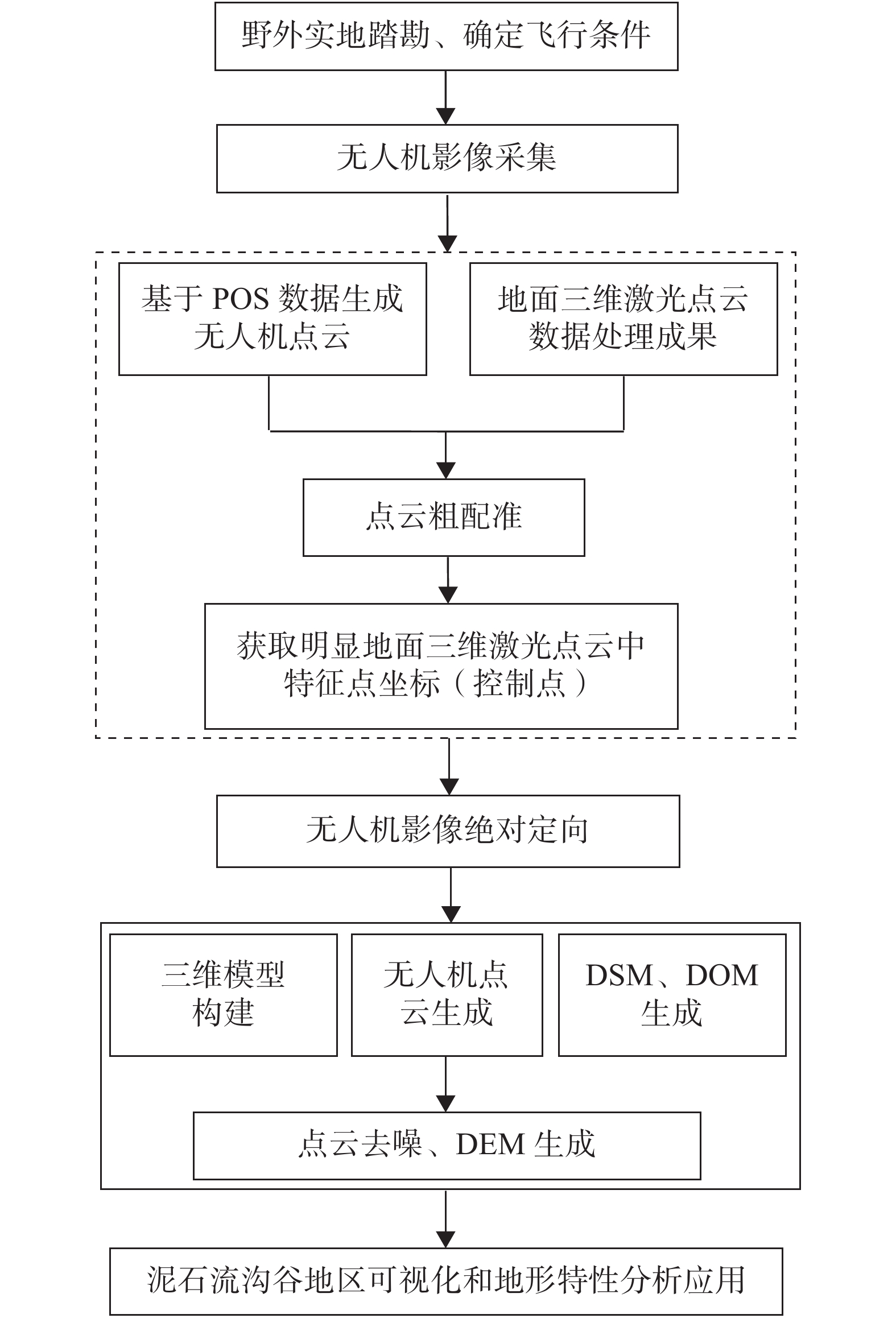
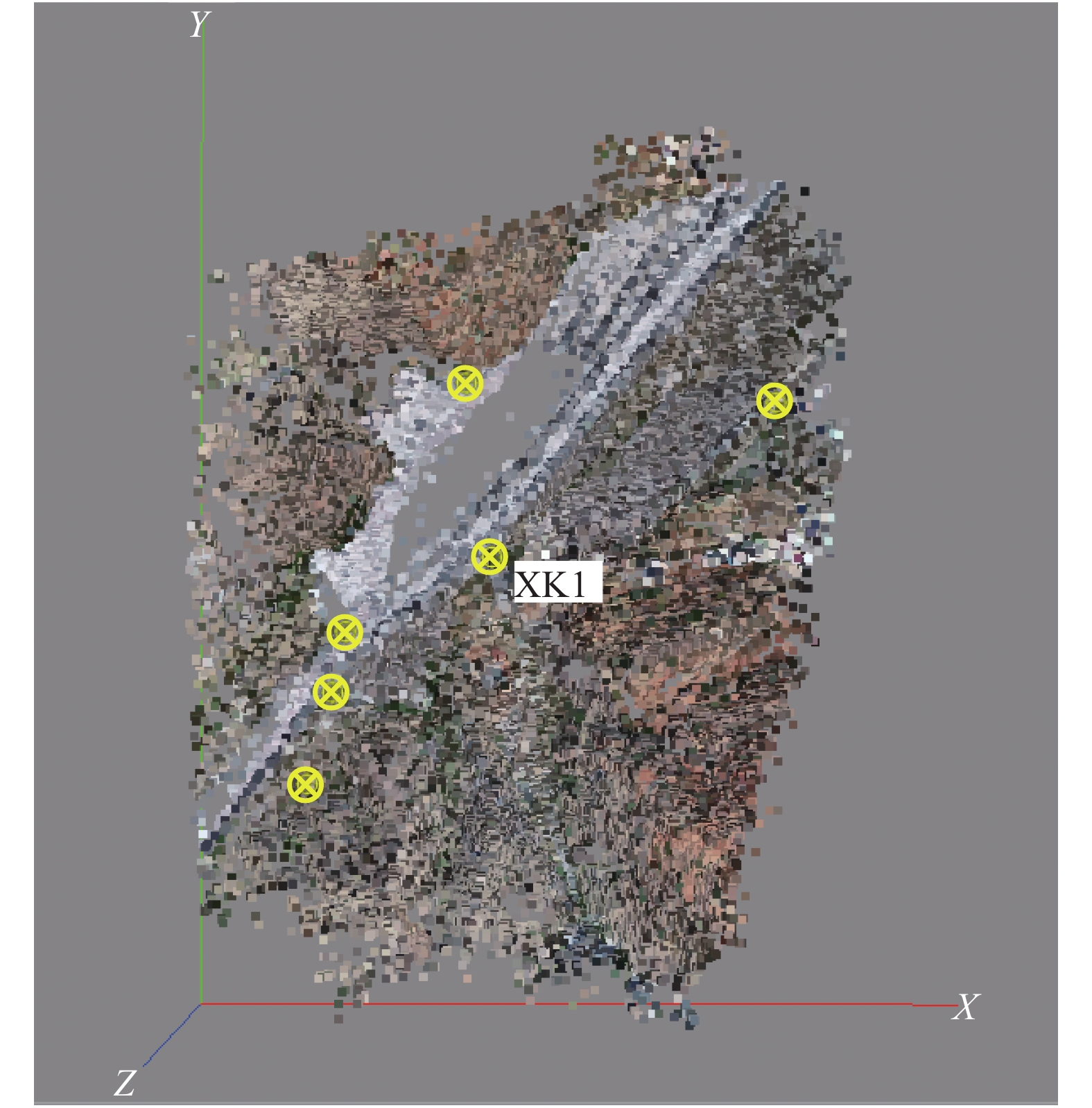
研究区选用大疆精灵4无人机进行点云数据采集,无人机飞行路径基于谷歌地球图像规划,具体工作区范围见图2(a)和2(c)。无人机搭载有定位系统(POS)和数据记录器,将在不同飞行高度以4 m/s的速度飞行,以产生高精度点云,并确定最佳飞行高度。图像在Agisoft PhotoScan Professional v 1.4.3中进行处理,点云的分辨率将降低到每米10点,进一步对每个点云图像进行滤波,去除植被覆盖等地表物体,生成裸地数字地形模型(DTM)。本次研究共获取周台子区无人机影像1399张像片,正射影像图细节见图2(b)和2(d),生成密集点云437009634个点,控制点误差0.0593355 m,生成白模共86849221个面,43449261个顶点三维模型大小约3.4 km²。
2. 技术方法
本研究结合研究区特点,创新性地制定了结合InSAR、无人机摄影测量以及三维激光扫描技术的具体的监测方案,联合应用InSAR、无人机摄影测量、三维激光扫描等技术建立矿区三维数字模型并进行采空区高风险区的确定,具体技术路线见图3。首先针对研究区利用InSAR技术进行地表形变监测,通过确定形变的异常值,来评估可能存在的采空区。然后利用无人机三维摄影测量从多角度调查矿区采空区周边的情况,主要通过控制点布设、联测,特征点选取,航线设计,数据采集以及数据处理等步骤,建立区域采空区高风险地区三维模型。在此基础上,进一步采用三维激光扫描技术,以基础测量为主,采集采空区地形数据,通过对获取的点云数据进行降噪处理等操作,生成二期数据成果—滑坡体DEM模型,最后开展立体等高线的生成和多结果叠加等研究。
2.1 InSAR技术
由于研究区采空区分布密集且地表植被覆盖茂密,本研究选取SBAS-InSAR技术进行地表形变监测,这种方法利用短时空基线的干涉对避免了空间失相关,同时减小地形对差分干涉的影响,与PSInSAR方法相比,极大提高了地表形变点的密度和干涉图的相干性[11-13]。其主要流程包括Sentinel-1 SAR预处理,即图像配准,Burst和子带拼接,差分干涉处理,相位滤波和相位解缠,时序形变解算等,具体流程图见图4。
该技术的具体流程如下:
Sentinel-1 SAR图像配准:首先对Sentinel-1数据进行预处理生成单视复数据,然后进行图像配准过程,主要分为Burst级数据处理、子带拼接等,由于Sentinel-1 数据方位向天线摆动,多普勒频率随Burst 时间线性变化,不再保持常量,此时对数据进行插值和滤波会出现较大问题,必须先对该多普勒频率变化引入的线性调频信号进行补偿,即在配准过程进行之前,先进行去斜Deramp 处理,然后再进行DEM配准和增强普分集(ESD)配准[13],在进行配准处理后,还需要将去除的Deramp相位重新进行补偿,即Reramp 操作,再进行后续的干涉处理。
Burst和子带拼接:对配准好的 Burst 数据进行拼接,去除重叠区域和黑边(无效值),生成完整的子带影像数据。然后将三个独立的子带数据进行拼接,去除子带间重叠区域,生成完整 SLC 影像数据。
差分干涉处理:在N+1景重复轨道时序SAR数据中,根据不同研究区及研究目标可以设置不同时空基线阈值选择M对干涉对(N为SAR图像个数,M为干涉对个数),然后进行差分干涉处理流程,由于平地相位和地形相位引起的干涉条纹会掩盖形变信息,需要利用 DEM 和轨道参数生成平地和模拟地形相位,然后从干涉图中减去这部分相位,最终得到了差分干涉图[14-16]。
相位滤波和相位解缠:由于相位噪声的影响干涉相位图会出现“毛刺”等现象将严重影响解缠速度和精度,通过相位滤波将干涉条纹处理清晰。采用最小费用流算法对相位进行解缠解决损失的以2nπ为模的整周缠绕数从而得到真实的干涉相位。
时序形变解算:SBAS-InSAR方法的核心算法是矩阵的奇异值分解求出最小范数意义上的最小二乘解。首先利用式(1)的线性模型估计其他M-1幅干涉图像的形变:
$$ A{\varPhi }=\delta{\varPhi } $$ (1) 式中:
$ {\varPhi } $ ——待求相干点上的 N 个未知相位组成的矩阵;$ \delta{\varPhi } $ ——M个干涉图上相位值组成的矩阵。系数矩阵
$ A[M\times N] $ 每一行对应于一个干涉图,每一列对应于一个时间上的 SAR 图像,主图像所在列为+1,辅图像所在列为−1,其余列为 0。将矩阵$ A[M\times N] $ 进行奇异值分解:$$ {A}={U}{S}{V}^{T} $$ (2) 式中:
$ {U} $ ——$ M\times M $ 的正交矩阵,由$ {A}{A}^{T} $ 的特征向量$ {u}_{i} $ 组成;$ V $ ——$ N\times N $ 的正交矩阵,由$ {A}^{T}A $ 的特征向量$ {v}_{i} $ 组成;${S}$ ——一个$ M\times M $ 的对角矩阵,对角线元素是${A}{A}^{T} $ 的特征值$ {{\lambda }}_{i} $ 。定义
${A} $ 的伪逆矩阵为$ {A}^{+} $ ,则有,$$ {A}^+=\sum _{i=1}^{R}\frac{1}{\sqrt{{\mathrm{\lambda }}_{i}}}{v}_{i}{u}_{i} $$ (3) 式中矩阵
${A} $ 的秩为R,则最小范数意义上的最小二乘相位估计为:$ \widehat{{\varPhi }}={A}^{+}\delta {\varPhi } $ 。2.2 无人机摄影测量建模技术
为解决InSAR技术中存在失相干和无法监大梯度形变的问题,本研究利用无人机摄影测量技术来提供研究区的正射影像,同时通过多期无人机生成的DEM、DSM的差分准确的定位大规模形变区,通过与InSAR技术的结合确定可能的采空区范围。具体无人机三维建模的流程见图5[17-19]。
该技术的具体流程如下:
本技术使用Agisoft PhotoScan Professional v 1.4.3软件进行三维建模处理使用软件加载影像,同时将整理好的控制点文件导入对空中三角测量成果进行控制加密。通过初步选取少许几个边缘控制点运行空三并基于空三结果预测其他控制点位置,为快速完成控制点的添加应将控制点设置在影像中心,添加完有控制点再次运行空三直至加密成功。采用光束法区域网平差得到每张影像的精确外方位元素,然后采用合适的影像匹配算法进行点云密集匹配三维点云生成三角网 TIN生成白模。通过配准 TIN模型的每一个三角面片与对应纹理影像进行模型自动纹理映射从而得到三维模型。分瓦片处理后建立 S3C 索引文件在同一坐标系最终的三维模型[11]。
2.3 LiDAR三维模型构建技术
为解决传统监测技术监测点密度小、监测精度低、监测周期长、监测点易损坏以及人员安全难以保证等问题,本研究使用三维激光扫描技术对研究区的采空区进行监测具体扫描建模流程图见图6。利用GPS RTK测量的大地坐标系将不同站点采集的点云数据配准到同一坐标系中。其次,采用多站点扫描采集数据,利用标靶拼接功能进行点云拼接。然后进行云滤波,该过程包括点云噪点剔除、植被剔除及点云密度抽稀。最后进行三维建模,基于三角形建模方法构建DEM,根据塌陷坑空间相邻三点可生成一个平面三角形,构成不规则三角网(TIN),三角网所覆盖的区域即为塌陷坑的地表。
2.4 风险区圈定的方法
本研究利用InSAR技术采用SBAS方法求得研究区的地表年平均LOS形变速率,根据其形变量初步确定矿区形变较大的区域为采空风险区。在此基础上,通过多期无人机摄影测量影像经过数据预处理、空三加密、DTM提取、正射影像生成对上述采空风险区进行精确分析(图7)。同时联合三维激光扫描地表位移形变结果进行交互验证,通过对比不同时间段形变速率变化、累积形变量的变化对潜在的采空风险区进行最终圈定,并结合调查区以往工程地质情况、矿山开采历史、矿山采矿作业方法等,如调查区形变速率异常增大且累积形变量明显高于其他区域即为潜在的高风险区。
3. 结果与分析
3.1 多技术联合监测结果
图8显示了研究区SBAS技术的形变速率结果图,形变速率范围为−14.3~6.37 mm/a。研究区呈现出该4处沉降区域,其中最大形变速率为−14.3 mm/a,该区域可能为采空风险区。由于研究区植被覆盖,地表起伏较大,见图9(b)(c),InSAR结果可能会受到时间去相干和部分大气延迟的影响,因此采用无人机监测结果对初步确定的隐患区进行精细分析。图9(a)为两期无人机监测期间影像上显示为多处大梯度形变区域,且沉降区形变为5~6 m,形变量较大的区域位于山坡区域,部分位为山间植被导致,滤除极值后,塌陷区上方仍有几处形变量较大区域,为开采岩壁边缘,有较大崩塌发生风险。无人机结果极大程度上克服了C波段的Sentinel-1数据在自然地表穿透能力差而造成的监测误差,且对于一些大梯度形变区域可进行有效监测。图10为研究区三维激光扫描处理结果图,此区域共扫描测站8站,点云9.6亿,通过点云拼接、去噪、滤除植被、及抽稀处理后,生成TIN三角网,并获取研究区高精度(10 cm)DTM栅格数据见图10(b)。通过LiDAR生成DTM与二期无人机生成DTM做差见图11,图中色块为无人机结果与LiDAR结果的差分沉降量。研究区5—6月、6—7月趋势相同,交叉验证了InSAR结果与无人机差分结果的准确性。
![]() 图 9 无人机DTM差分地表形变图及实景模型(区块三)Figure 9. UAV DTM differential surface deformation diagram and real scene model in block 3
图 9 无人机DTM差分地表形变图及实景模型(区块三)Figure 9. UAV DTM differential surface deformation diagram and real scene model in block 33.2 高风险区域的确定
图12为InSAR形变的结果与无人机生成的三维实景模型叠合图,全区整体形变情况较为稳定。图12(d)显示研究区基于升轨Sentinel-1数据视线向形变速率范围为−25~16 mm/a,图12(e)显示基于降轨Sentinel-1数据视线向形变速率范围为−19~12 mm/a,整体体现为微弱下降趋势。以InSAR的结果为基础,将形变区间大于±5 mm/a区域划分为高风险形变区域。根据SAR数据升轨形变反演结果共识别高风险形变区域22处,主要分布在区块一、区块二、区块四和区块八,见图12(b),部分位于矿区范围外即研究区域的东南侧。根据降轨形变反演结果识别高风险形变区域21处,主要分布在区块一、区块二、区块三、区块四和区块八,部分位于矿区范围外即研究区域的东南侧。由于数据集的观测周期、LOS向和研究区坡度方向原因,升降轨的结果之间存在微小差异,但是基于Senttinel-1数据升降轨结果形变趋势一致,且根据形变信息确定的高风险区域符合。
![]() 图 12 InSAR、无人机多角度对比综合分析图Figure 12. Multi angle comparison and comprehensive analysis of InSAR and UAV
图 12 InSAR、无人机多角度对比综合分析图Figure 12. Multi angle comparison and comprehensive analysis of InSAR and UAV3.3 区域的精细分析
将InSAR探测出的密集高下降速率点分区,对八个采区分别进行了局部区域监测,识别形变幅度大于±5 mm/a确定为高风险形变区,形变幅度虽小于±5 mm/a确定为潜在隐患区域。本文将对形变隐患严重的区域区块一、区块二、区块三和区块八进行精细分析。
3.3.1 采空区局部监测结果:区块1(启泰采区)
区块1位于周台子西北方,其中包括启泰采区和部分华兵采区。图13(a)(c)显示该区块升轨结果的形变速率范围为−12~6 mm/a。根据形变结果识别高风险形变区6处,其中4处位于矿区内部,2处位于矿区外部西南处;潜在隐患区域1处,位于矿区南处。图13(b)(d)显示该区块降轨结果的形变速率范围−11~12 mm/a。根据形变结果识别高风险形变区6处,潜在隐患区域3处。基于多期无人机测量、LiDAR扫描差分结果、InSAR形变速率结果综合分析,圈定高风险区域处见图13红色圆圈区域,升轨识别得到的高风险区域主要在采空区西测山坡和矿井处,降轨识别得到的高风险区域主要分布于采区矿井处和东部山坡。此外,采区外同样分布有高形变速率区域存在,主要位于采区外西侧和东侧的山坡处,通过无人机与LiDAR差分DTM结果对比,仍存在较大形变,具有潜在发生滑坡和塌陷的风险。
![]() 图 13 区块1多结果叠合高风险采空区区域图Figure 13. Regional map of high-risk goaf with multi result superposition in block 1
图 13 区块1多结果叠合高风险采空区区域图Figure 13. Regional map of high-risk goaf with multi result superposition in block 13.3.2 采空区局部监测结果:区块2(华兵老达子沟采区)
区块2位于周台子西北方,其中包括华兵矿区和老达子沟矿区。图14(a)(c)显示升轨SAR数据的形变速率范围为−11~9 mm/a,整体稳定。该区域植被覆盖茂密,形变结果可能会受到去相干的影响。图14(d)表明降轨数据由于入射角与坡向较吻合,其结果可更好地探测出该区域形变位置。但是升降轨结果探测的风险区地理位置基本一致。根据形变结果识别高风险形变区6处;潜在隐患区域5处,其中4处位于矿区内部,1处位于矿区外部东北处。图14(b)(d)显示降轨SAR数据形变速率范围为−13~9 mm/a,整体稳定。根据形变结果识别高风险形变区8处,其中6处位于矿区内部,2处位于矿区外部东北处和西南处;潜在隐患区域4处。基于多期无人机测量、LiDAR扫描差分结果、InSAR形变速率结果综合分析,圈定高风险区域处见图14红色圆圈区域,主要分布于采区内中部区域,以建筑物和山坡为主。此外,采区外同样分布有高形变速率区域存在,主要位于采区西南处,该区域为山体,有着较大的沉降速率,同样存在着较大形变。
![]() 图 14 区块2多结果叠合高风险采空区区域图Figure 14. Regional map of high-risk goaf with multi result superposition in block 2
图 14 区块2多结果叠合高风险采空区区域图Figure 14. Regional map of high-risk goaf with multi result superposition in block 23.3.3 采空区局部监测结果:区块3(大矿采区)
区块3为于周台子村北部,内有一条西北-东南向大沟谷。经无人机三维建模测量,长约670 m,宽逾百米,最深处超80 m,两侧峭壁非常陡峭,几近垂直,上坡边缘大量碎石堆积,周边坡体破坏严重,植被覆盖度低。图15(a)(c)显示升轨SAR数据的形变速率范围为−8~5 mm/a,整体稳定。根据形变结果识别潜在隐患区域12处,其中8处位于矿区内部,4处位于矿区外部东北处和西南处。图15(b)(d)显示降轨SAR数据的形变速率范围为−8~11 mm/a。根据形变结果识别高风险形变区4处,其中3处位于矿区内部,1处位于矿区外部东北处;潜在隐患区域11处,其中6处位于矿区内部,5处位于矿区外部东北处和西南处。应用无人机和LiDAR三维激光扫描可监测出高形变区域,此区域地表破坏较为严重,亦有植被覆盖。差分DTM结果显示此处有形变明显,沉降程度大,最大形变值可达10 m,位于坡顶及沿着峭壁边缘,极大可能为不稳定坡体滑塌所致。基于多期无人机测量、LiDAR扫描差分结果、InSAR形变速率结果综合分析,圈定高风险区域处见图15红色圆圈区域,主要分布于采区内中部沟谷处,同时采区北侧也为高沉降速率区域,有坍塌风险。采区外西部及南部区域同样有着高沉降速率。
![]() 图 15 区块3多结果叠合高风险采空区区域图Figure 15. Regional map of high-risk goaf with multi result superposition in block 3
图 15 区块3多结果叠合高风险采空区区域图Figure 15. Regional map of high-risk goaf with multi result superposition in block 33.3.4 采空区局部监测结果:区块8(三采区)
区块8位于周台子村南部,隶属于三采区。内有居民住宅、学校和主要路段等人群密集处,区域内路基断裂,山体破坏,植被稀疏。图16(a)(c)显示升轨SAR数据的形变速率范围为−10~9 mm/a,由于建筑区在SAR图像上表现为强散射体,受到时空去相干影响较小,因此该区域形变趋势整体稳定。根据形变结果识别高风险形变区2处;潜在隐患区域2处。图16(b)(d) 显示降轨SAR数据的形变速率范围为−14~11 mm/a,整体稳定。根据形变结果识别高风险形变区3处;潜在隐患区域1处,位于矿区外部东北处,为采空区的可能性极高。区块8在无人机影像主要体现大量级大规模形变,两期无人机监测期间,塌陷区沉降明显,断裂路基处最大可达5~6 m,无人机探测区块8内部形变量较大区域以山坡区域为主,为山间植被导致,滤除极值后,塌陷区上方仍有几处形变量较大区域,有较大滑坡发生风险。基于多期无人机测量、LiDAR扫描差分结果、InSAR形变速率结果综合分析,圈定高风险区域处见图16的红色圆圈区域,主要分布于采区内西部区域,不稳定坡体、周边居民区及道路处同样有着较大的沉降速率,有一定塌陷的风险性。
![]() 图 16 区块8多结果叠合高风险采空区区域图Figure 16. Regional map of high-risk goaf with multi result superposition in block 8
图 16 区块8多结果叠合高风险采空区区域图Figure 16. Regional map of high-risk goaf with multi result superposition in block 84. 结论
通过时序InSAR监测分析、2期无人机正射模型DEM与三维激光扫描数据差分得出以下结论:
(1) 研究以SBAS技术反演的形变结果同时结合多期无人机、LiDAR差分结果确定出17处高风险形变区域,并逐一对4个区块内的高风险形变区域和潜在隐患区域进行分析。
(2) 高风险区域分布在各个矿区,部分对居民区、道路、广场等有影响。升轨SAR数据形变结果显示高风险形变区域主要分布在区块一、区块二、区块四和区块八,部分位于矿区范围外即研究区域的东南侧。降轨SAR数据形变反演结果显示高风险形变区域主要分布在区块一、区块二、区块三和区块八,部分位于矿区范围外即研究区域的东南侧,基于Sentinel-1升降轨SAR数据形变趋势基本一致。后续将利用不同波段的SAR数据进行研究区地表形变精细化监测,同时利用升降轨数据进一步求出研究区的三维形变,与GPS数据进行联合监测。
(3)C波段的Sentinel-1数据由于波长较短,InSAR技术在植被茂密和形变梯度较大区域由于失相干原因导致形变结果存在较大误差。通过无人机和LiDAR技术极大提高了研究区监测点的密度,加强了高风险形变区域的精确评估。基于空天地的InSAR、无人机摄影测量以及三维激光扫描技术展示了在矿区采空区形变调查中的应用潜力。
-
表 1 无人机基本参数
Table 1 Basic parameters of UAV
名称 参数 无人机型号 Phantom 4 Pro 相机型号 FC6310 影像传感器 CMOS 1英寸 相机像素 2000万(5472×3648) 最大光圈 F/2.8 定位信息 GPS/GLONASS双模式定位系统 视场角(FOV)/(°) 84 最快飞行速度/( m•s-1) 20 飞行时间/min 约30 工作环境温度/℃ 0 ~40  下载: 导出CSV
表 2 飞行参数
Table 2 Flight parameters
航高/m 飞行角度 镜头倾角/(°) 影像数量 架次 航线数量 重叠度/% 300 正视 90 91 1 10 70 左视 60 95 1 6 右视 88 1 8
下载: 导出CSV
-
[1] 李家春, 宋宗昌, 侯少梁, 等. 北斗高精度定位技术在边坡变形监测中的应用[J]. 中国地质灾害与防治学报,2020,31(1):70 − 74. [LI Jiachun, SONG Zongchang, HOU Shaoliang, et al. Application of Beidou high-precision positioningtechnology in slope deformation monitoring[J]. The Chinese Journal of Geological Hazard and Control,2020,31(1):70 − 74. (in Chinese with English abstract) [2] 李明威, 唐川, 陈明, 等. 汶川震区北川县泥石流流域崩滑体时空演变特征[J]. 水文地质工程地质,2020,47(3):182 − 190. [LI Mingwei, TANG Chuan, CHEN Ming, et al. Spatio-temporal evolution characteristics of landslides in debris flow catchment in Beichuan County in the Wenchuan earthquake zone[J]. Hydrogeology & Engineering Geology,2020,47(3):182 − 190. (in Chinese with English abstract) [3] 赵富萌, 张毅, 孟兴民, 等. 基于小基线集雷达干涉测量的中巴公路盖孜河谷地质灾害早期识别[J]. 水文地质工程地质,2020,47(1):142 − 152. [ZHAO Fumeng, ZHANG Yi, MENG Xingmin, et al. Early identification of geological hazards in the Gaizi valley near the Karakoran Highway based on SBAS-InSAR technology[J]. Hydrogeology & Engineering Geology,2020,47(1):142 − 152. (in Chinese with English abstract) [4] 杨明生. 长时序多源遥感的滑坡变化监测方法研究[D]. 北京: 中国科学院大学(中国科学院遥感与数字地球研究所), 2018. YANG Mingsheng. Method research on landslide Change monitoring based on Long Time Series Multi-source remote sensing [D]. Beijing: University of Chinese Academy of Science(Institute of Remote Sensing and Digital Earth Chinese Academy of Sciences), 2018. (in Chinese)
[5] 范敏, 孙小飞, 苏凤环, 等. 国产高分卫星数据在西南山区地质灾害动态监测中的应用[J]. 国土资源遥感,2017,29(增刊1):85 − 89. [FAN Min, SUN Xiaofei, SU Fenghuan, et al. Application analysis of remote sensing dynamic monitoring for geological hazards in southwest mountainous areas using domestic high resolution satellite data[J]. Remote Sensing for Land and Resources,2017,29(Sup1):85 − 89. (in Chinese with English abstract) [6] 葛大庆, 戴可人, 郭兆成, 等. 重大地质灾害隐患早期识别中综合遥感应用的思考与建议[J]. 武汉大学学报(信息科学版),2019,44(7):949 − 956. [GE Daqing, DAI Keren, GUO Zhaocheng, et al. Early identification of serious geological hazards with integrated remote sensing technologies: Thoughts and recommendations[J]. Geomatics and Information Science of Wuhan University,2019,44(7):949 − 956. (in Chinese with English abstract) [7] 康玉霄, 桑文刚, 李娜, 等. 无人机低空摄影测量数据处理及应用[J]. 测绘通报,2017(增刊1):62 − 65. [KANG Yuxiao, SANG Wengang, LI Na, et al. Unmanned aerial vehicle low-altitude photogrammetry data processingand application[J]. Bulletin of Surveying and Mapping,2017(Sup1):62 − 65. (in Chinese with English abstract) [8] 毕凯, 李英成, 丁晓波, 等. 轻小型无人机航摄技术现状及发展趋势[J]. 测绘通报,2015(3):27 − 31. [BI Kai, LI Yingcheng, DING Xiaobo, et al. Aerial photogrammetric technology of light small UAV: Statusand trend of development[J]. Bulletin of Surveying and Mapping,2015(3):27 − 31. (in Chinese with English abstract) [9] 郭学飞, 焦润成, 曹颖, 等. 倾斜摄影测量技术在崩塌隐患调查评价中的应用[J]. 中国地质灾害与防治学报,2020,31(1):65 − 69. [GUO Xuefei, JIAO Runcheng, CAO Ying, et al. Application of oblique photography in the investigationpotential of rockfall[J]. The Chinese Journal of Geological Hazard and Control,2020,31(1):65 − 69. (in Chinese with English abstract) [10] HUANG H F, SONG K, YI W, et al. Use of multi-source remote sensing images to describe the sudden Shanshucao landslide in the Three Gorges Reservoir, China[J]. Bulletin of Engineering Geology and the Environment,2019,78(4):2591 − 2610.
[11] JI H W, LUO X Q. 3D scene reconstruction of landslide topography based on data fusion between laser point cloud and UAV image[J]. Environmental Earth Sciences,2019,78(17):1 − 12.
[12] 巨袁臻. 基于无人机摄影测量技术的黄土滑坡早期识别研究[D]. 成都: 成都理工大学, 2017. JU Yuanzhen. Early recognition of loess landslide based on UAV photogrammetry—A case study of Heifang Terrace [D]. Chengdu: Chengdu University of Technology, 2017. (in Chinese)
[13] 黄海峰, 林海玉, 吕奕铭, 等. 基于小型无人机遥感的单体地质灾害应急调查方法与实践[J]. 工程地质学报,2017,25(2):447 − 454. [HUANG Haifeng, LIN Haiyu, LYU Yiming, et al. Micro Unmanned Aerial Vehicle Based Remote Sensing Method and Application for Emergency Survey of Individual Geohazard[J]. Journal of Engineering Geology,2017,25(2):447 − 454. (in Chinese with English abstract) [14] 王庆国, 赵海, 李健平. 地面激光点云与航空影像相结合的滑坡监测[J]. 测绘通报,2019(4):99 − 102. [WANG Qingguo, ZHAO Hai, LI Jianping. Landslide monitoring by merging ground laser point cloud and aerial image[J]. Bulletin of Surveying and Mapping,2019(4):99 − 102. (in Chinese with English abstract) [15] SOTIRIS V, GEORGE P, ATHANASSIOS G. Mapping an earthquake-induced landslide based on UAV imagery; case study of the 2015 Okeanos landslide, Lefkada, Greece[J]. Engineering Geology, 2018, 245: 141-152.
[16] DARREN T, ARKO L, STEVEN D J. Time series analysis of landslide dynamics using an Unmanned Aerial Vehicle (UAV)[J]. Remote Sensing,2015,7(2):1736 − 1757.
[17] 于辉, 甘淑, 杨敏, 等. 东川小江流域典型沟谷泥石流迹地环境综合遥感解译分析[J]. 地质灾害与环境保护,2017,28(3):96 − 100. [YU Hui, GAN Shu, YANG Min, et al. Comprehensive remote sensing interpretation analysis of typical gully debris flow environment of Xiaojiang River Basin in Dongchuan Country[J]. Journal of Geological Hazards and Environment Preservation,2017,28(3):96 − 100. (in Chinese with English abstract) DOI: 10.3969/j.issn.1006-4362.2017.03.019 [18] 杨敏, 甘淑, 袁希平, 等. 复杂带状地形条件下的地面三维激光扫描点云数据采集与配准处理试验[J]. 测绘通报,2018(5):35 − 40. [YANG Min, GAN Shu, YUAN Xiping, et al. Study on data acquisition and registration experiment of terrestrial laser scanning point clouds under complicated banded terrain condition[J]. Bulletin of Surveying and Mapping,2018(5):35 − 40. (in Chinese with English abstract) [19] FRANCISCO A V, FERNANDO C R, PATRICIO M C, et al. Reconstruction of extreme topography from UAV structure from motion photogrammetry[J]. Measurement,2018,121:127 − 138.
-
期刊类型引用(8)
1. 程强,周兴泉,张肖. 四川新市—金阳公路唐家湾滑坡变形特征和形成机理分析. 中国地质灾害与防治学报. 2025(01): 46-56 .  本站查看
本站查看
2. 杨腾飞,严志文. 无人机航测技术在露天矿山采空区勘探中的应用. 中国新技术新产品. 2024(02): 89-91 . 百度学术
3. 黄荣. 无人机倾斜摄影测量技术在地灾监测中的应用. 地下水. 2024(02): 179-181+267 . 百度学术
4. 蒋李亚. 基于“天地一体化”分析风电场边坡水土流失情况——以南方某风电场为例. 农业灾害研究. 2024(05): 317-319 . 百度学术
5. 孙文庆,张忠辉,高新妍,忽巍,王延伟. 附加模型补偿的多期GNSS网监测. 测绘标准化. 2024(03): 150-157 . 百度学术
6. 王瑞. 基于三维激光扫描技术的植物园林假山沉降监测方法. 激光杂志. 2024(11): 209-213 . 百度学术
7. 李文龙. 机载LiDAR技术在广州黄埔区地质灾害调查中的应用. 中国地质灾害与防治学报. 2024(06): 164-172 . 本站查看
8. 李大猛,孙东,余辉,李松,张正鹏. 绿色矿山建设与矿山生态修复关联探析. 世界有色金属. 2023(22): 162-165 . 百度学术
其他类型引用(0)


计量
- 文章访问数: 487
- HTML全文浏览量: 302
- PDF下载量: 701
- 被引次数: 8
 邮件订阅
邮件订阅 RSS
RSS